
.gif)
Route 21 (New Jersey)
Encyclopedia
Route 21 is a highway in northern New Jersey
, running 14.35 mi (23.09 km) from the Newark Airport Interchange
with U.S. Route 1/9
and U.S. Route 22
in Newark
, Essex County
to an interchange with U.S. Route 46
in Clifton
, Passaic County
. The route is a four- to six-lane divided highway
known as McCarter Highway on its southern portion in Newark that serves as a connector between the Newark and Paterson
areas, following the west bank of the Passaic River
for much of its length. It also serves as the main north–south highway through the central part of Newark, connecting attractions in downtown Newark
with the Newark Liberty International Airport
. The portion of Route 21 through Newark is a surface arterial that follows the Northeast Corridor
rail line through the southern part of the city and continues north through Downtown Newark while the portion north of Downtown Newark is a freeway. Route 21 intersects many major roads including Interstate 78
, Route 27, and Interstate 280
in Newark, Route 7 in Belleville
, and Route 3 in Clifton.
Route 21 was created in 1927 to run from Newark to Belleville. In 1948, the route was extended north to Paterson. In the 1950s construction began on the freeway portion of Route 21 and it was completed in stages between Chester Avenue in Newark and Monroe Street in Passaic
between 1958 and 1973. Plans were made to extend the freeway north to Interstate 80
in Elmwood Park
; however, they were opposed by residents living on the east side of the Passaic River. In the 1980s, another northern extension of the Route 21 freeway was proposed to U.S. Route 46 in Clifton; this section was built between 1997 and 2000. The surface portion of Route 21 through Newark underwent many improvements in the 1990s and 2000s.
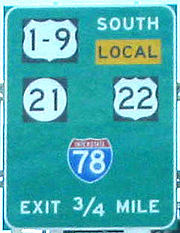 Route 21 heads north from the Newark Airport Interchange
with U.S. Route 1/9
and U.S. Route 22
in Newark
near the Newark Liberty International Airport
on the six-lane, divided McCarter Highway. This portion of Route 21 serves to connect Newark Liberty with downtown Newark
. The route interchanges with Interstate 78
and then crosses over the Northeast Corridor
rail line on a viaduct, coming to an interchange with Broad Street that provides access to Route 27. The route continues north, paralleling the elevated Northeast Corridor (former Pennsylvania Railroad
) tracks that lead up to Newark Penn Station
. At the Emmet Street intersection, Route 21 becomes a four-lane, undivided road and intersects Murray Street, which provides access to the Ironbound
neighborhood of Newark. This section of Route 21 through the southern part of Newark has a high accident rate due to the heavy concentration of businesses and traffic lights along this portion of road. The road widens to six lanes and the route intersects County Route 510
(Market Street) near Newark Penn Station and continues north into downtown Newark
, splitting from the Northeast Corridor rail line. It crosses Raymond Boulevard
and the route meets County Route 508
(Center Street), with which it forms a concurrency
.
Route 21 and County Route 508 head along the west bank of the Passaic River
, passing by the New Jersey Performing Arts Center
. County Route 508 splits from Route 21 by heading east on Bridge Street, crossing the Passaic River, and Route 21 continues north, passing by Bears & Eagles Riverfront Stadium
before interchanging with Interstate 280
. The route intersects County Route 506 Spur (Clay Street). Past the intersection with 3rd Avenue, Route 21 becomes a six-lane, double-decker freeway that passes by a cemetery. It turns into a single-level freeway and interchanges with Chester Avenue/Riverside Avenue with a southbound exit and northbound entrance. Route 21 comes to a northbound exit and southbound entrance for Grafton Avenue and Mill Street, briefly becoming a double-decker freeway again past that interchange before crossing into Belleville
at the Second River
crossing. The freeway features a southbound exit for Mill Street and a northbound exit for Route 7 and County Route 506
(Rutgers Street/Belleville Turnpike) as it passes by houses on the left side of the freeway. Route 21 features an interchange with Main Street that has a southbound exit and an entrance in both directions. It enters Nutley
where the freeway interchanges with County Route 646 (Park Avenue), continuing north through residential areas along the Passaic River.
 Route 21 crosses into Clifton
, Passaic County
. It passes under Route 3 and comes to an interchange that provides access to that route. Past Route 3, the freeway comes to a northbound exit and southbound entrance for southbound County Route 624 (River Road), passing through residential neighborhoods, and enters Passaic
. In Passaic, Route 21 interchanges with County Route 608 (Brook Avenue), County Route 614 (Van Houten Avenue), and County Route 624. The route features an interchange with County Route 624 (River Drive) and County Route 601 (Main Avenue) and meets State Street at a partial interchange with a northbound exit and southbound entrance. Route 21 briefly enters Wallington
, Bergen County
before crossing back into Passaic, where it heads farther to the west of the Passaic River, passing through industrial and residential areas of Passaic. The freeway comes to an interchange that provides access to County Route 619 (Market Street), Dayton Avenue, and Monroe Street. Route 21 continues to the north and resumes along the west bank of the Passaic River, narrowing to four lanes and crossing back into Clifton. Upon entering Clifton, the route comes to an interchange with Ackerman Avenue. The freeway heads to the northwest, passing by a park and featuring a southbound exit and northbound entrance for Lexington Avenue before ending at an interchange with U.S. Route 46
.
 Route 21 was first defined in the 1927 New Jersey state highway renumbering
to run from Route 25 (now U.S. Route 1/9) and Route 29 (now U.S. Route 22) in Newark north to Belleville. The surface portion of Route 21 in Newark, which follows the Northeast Corridor rail line, was commissioned in 1934 between Routes 25 and 29 and Market Street and the portion through downtown Newark was commissioned in 1936 between Market Street and Clay Street. In 1948, the Route 21 designation was extended north to Paterson
.
Plans for a freeway along the Route 21 corridor between Newark and Paterson date back to the early 1930s and became official in 1951. In 1958, the highway was extended northward as a freeway along the west bank of the Passaic River to an interchange with Park Avenue in Nutley. Route 21 was extended to the Passaic Park interchange in 1962, Main Avenue in 1968, and Monroe Street in 1973. With the completion of the freeway, a portion of the former route was briefly known as Route 21A.
The Route 21 freeway was planned to extend north to Interstate 80
in Elmwood Park
at the interchange with County Route 507
, crossing over the Passaic River. However, this extension was opposed by residents who lived on the east side of the Passaic River, and for a quarter-century, traffic headed for Paterson had to use local streets in Passaic. In the 1980s, plans were resurrected for completing the Route 21 freeway along the west bank of the Passaic River to U.S. Route 46 in Clifton. Official plans were made in 1996, and in late 1997, construction began on this portion of the freeway. It opened on December 20, 2000 at a cost of $136 million.
Sections of Route 21 through Newark were improved in the 1990s and the 2000s. The four-lane viaduct over the Northeast Corridor, which was built in the 1920s, was replaced between 1997 and 2003 at a cost of $43 million. In 2006, Route 21 was improved and widened to six lanes in downtown Newark, where the road passes features such as Bears and Eagles Riverfront Stadium, the New Jersey Performing Arts Center, and the Prudential Center. Despite these improvements, there are currently no plans for a freeway along the section of Route 21 through Newark.
}
|Interchange
|-
|3.37
|
|
|
|-
|3.90
|colspan=3 align="center"|South end of freeway
|-
|4.62
|4
|Chester Avenue, Riverside Avenue
|Southbound exit and northbound entrance
|-
|5.32
|5
|Grafton Avenue, Mill Street – North Newark
|Northbound exit and southbound entrance
|-
|rowspan=3|Belleville
|5.83
|5
|Mill Street – Belleville
, North Newark
|Southbound exit only
|-
|6.17
|6
|
|Northbound exit only
|-
|6.73
|7
|Main Street – Belleville
|No northbound exit
|-
|Nutley
|8.00
|8
|
|
|-
|rowspan=9|Passaic
|rowspan=2|Clifton
|9.28
|9
|
|
|-
|9.94
|10A
|
|Northbound exit and southbound entrance
|-
|rowspan=4|Passaic
|10.39
|10B
|
|Signed as exit 10 southbound
|-
|11.27
|11A
|
|Signed as exit 11 southbound
|-
|11.74
|11B
|State Street – Passaic
|Northbound exit and southbound entrance
|-
|12.60
|12
|, Dayton Avenue, Monroe Street - Passaic
|
|-
|rowspan=3|Clifton
|13.52
|13
|Ackerman Avenue, Randolph Avenue – Botany Village, Garfield
|
|-
|14.16
|14
|Lexington Avenue
|Southbound exit and northbound entrance
|-
|14.35
|
|
|Northbound exit and southbound entrance
New Jersey
New Jersey is a state in the Northeastern and Middle Atlantic regions of the United States. , its population was 8,791,894. It is bordered on the north and east by the state of New York, on the southeast and south by the Atlantic Ocean, on the west by Pennsylvania and on the southwest by Delaware...
, running 14.35 mi (23.09 km) from the Newark Airport Interchange
Newark Airport Interchange
The Newark Airport Interchange is a massive interchange of Interstate 78, U.S. Route 1/9, U.S. Route 22, Route 21, and Interstate 95 at the northern edge of Newark Airport in Newark, New Jersey.-Description:...
with U.S. Route 1/9
U.S. Route 1/9
U.S. Route 9 is a U.S. highway in the northeast United States, running from Laurel, Delaware north to the Canadian border near Champlain, New York...
and U.S. Route 22
U.S. Route 22 in New Jersey
U.S. Route 22 is a U.S. highway stretching from Cincinnati, Ohio in the west to Newark, New Jersey in the east. In New Jersey, the route runs for from the Easton-Phillipsburg Toll Bridge over the Delaware River in Phillipsburg, Warren County to Interstate 78 , US 1/9, and Route 21 at the Newark...
in Newark
Newark, New Jersey
Newark is the largest city in the American state of New Jersey, and the seat of Essex County. As of the 2010 United States Census, Newark had a population of 277,140, maintaining its status as the largest municipality in New Jersey. It is the 68th largest city in the U.S...
, Essex County
Essex County, New Jersey
Essex County is a county located in the northeastern part of the U.S. state of New Jersey. As of the United States 2010 Census, the population was 783,969, ranking it third in the state after Bergen County and Middlesex County; Essex County's population has declined from 786,147 as of the bureau's...
to an interchange with U.S. Route 46
U.S. Route 46
U.S. Route 46 is an east–west U.S. Highway, running for , completely within the state of New Jersey. The west end is at an interchange with Interstate 80 and Route 94 in Columbia, Warren County on the Delaware River...
in Clifton
Clifton, New Jersey
Clifton is a city in Passaic County, New Jersey, United States. As of the 2010 United States Census, the city had a total population of 84,136. The 2010 population represented an increase of 5,464 residents from its population of 78,672 in the 2000 Census, making it the state's 11th largest...
, Passaic County
Passaic County, New Jersey
Passaic County is a county located in the U.S. state of New Jersey. As of the 2010 Census, the population was 501,226. Its county seat is Paterson...
. The route is a four- to six-lane divided highway
Divided Highway
Divided Highway is a compilation album by American rock band The Doobie Brothers, released in 2003. . All tracks are taken from the albums Cycles and Brotherhood .-Track listing:...
known as McCarter Highway on its southern portion in Newark that serves as a connector between the Newark and Paterson
Paterson, New Jersey
Paterson is a city serving as the county seat of Passaic County, New Jersey, United States. As of the 2010 United States Census, its population was 146,199, rendering it New Jersey's third largest city and one of the largest cities in the New York City Metropolitan Area, despite a decrease of 3,023...
areas, following the west bank of the Passaic River
Passaic River
The Passaic River is a mature surface river, approximately 80 mi long, in northern New Jersey in the United States. The river in its upper course flows in a highly circuitous route, meandering through the swamp lowlands between the ridge hills of rural and suburban northern New Jersey,...
for much of its length. It also serves as the main north–south highway through the central part of Newark, connecting attractions in downtown Newark
Downtown Newark
Downtown Newark is Newark, New Jersey's major central business, retail, and cultural district. It is located at a bend in the Passaic River.Downtown is the site of the original Puritan settlement of Newark. The first settlers, led by Robert Treat, landed not far from the present site of the New...
with the Newark Liberty International Airport
Newark Liberty International Airport
Newark Liberty International Airport , first named Newark Metropolitan Airport and later Newark International Airport, is an international airport within the city limits of both Newark and Elizabeth, New Jersey, United States...
. The portion of Route 21 through Newark is a surface arterial that follows the Northeast Corridor
Northeast Corridor
The Northeast Corridor is a fully electrified railway line owned primarily by Amtrak serving the Northeast megalopolis of the United States from Boston in the north, via New York to Washington, D.C. in the south, with branches serving other cities...
rail line through the southern part of the city and continues north through Downtown Newark while the portion north of Downtown Newark is a freeway. Route 21 intersects many major roads including Interstate 78
Interstate 78 in New Jersey
Interstate 78 is an east–west route stretching from Union Township, Lebanon County, Pennsylvania to New York City. In New Jersey, I-78 is called the Phillipsburg–Newark Expressway and the Newark Bay Extension of the New Jersey Turnpike...
, Route 27, and Interstate 280
Interstate 280 (New Jersey)
Interstate 280 is a Interstate Highway in the U.S. state of New Jersey. It provides a spur from I-80 in Parsippany-Troy Hills, Morris County to Newark, and I-95 Interstate 280 (abbreviated I-280) is a Interstate Highway in the U.S. state of New Jersey. It provides a spur from I-80 in...
in Newark, Route 7 in Belleville
Belleville, New Jersey
Belleville is a Township in Essex County, New Jersey, United States. As of the 2010 United States Census, the township population was 35,926.-History:...
, and Route 3 in Clifton.
Route 21 was created in 1927 to run from Newark to Belleville. In 1948, the route was extended north to Paterson. In the 1950s construction began on the freeway portion of Route 21 and it was completed in stages between Chester Avenue in Newark and Monroe Street in Passaic
Passaic, New Jersey
Passaic is a city in Passaic County, New Jersey, United States. As of the 2010 United States Census, the city had a total population of 69,781, maintaining its status as the 15th largest municipality in New Jersey with an increase of 1,920 residents from the 2000 Census population of 67,861...
between 1958 and 1973. Plans were made to extend the freeway north to Interstate 80
Interstate 80 in New Jersey
Interstate 80 is a major Interstate Highway in the United States, running from the New York City Metropolitan Area westward to San Francisco, California...
in Elmwood Park
Elmwood Park, New Jersey
Elmwood Park is a borough in Bergen County, New Jersey, United States. As of the 2010 United States Census, the borough population was 19,403....
; however, they were opposed by residents living on the east side of the Passaic River. In the 1980s, another northern extension of the Route 21 freeway was proposed to U.S. Route 46 in Clifton; this section was built between 1997 and 2000. The surface portion of Route 21 through Newark underwent many improvements in the 1990s and 2000s.
Essex County
Newark Airport Interchange
The Newark Airport Interchange is a massive interchange of Interstate 78, U.S. Route 1/9, U.S. Route 22, Route 21, and Interstate 95 at the northern edge of Newark Airport in Newark, New Jersey.-Description:...
with U.S. Route 1/9
U.S. Route 1/9
U.S. Route 9 is a U.S. highway in the northeast United States, running from Laurel, Delaware north to the Canadian border near Champlain, New York...
and U.S. Route 22
U.S. Route 22 in New Jersey
U.S. Route 22 is a U.S. highway stretching from Cincinnati, Ohio in the west to Newark, New Jersey in the east. In New Jersey, the route runs for from the Easton-Phillipsburg Toll Bridge over the Delaware River in Phillipsburg, Warren County to Interstate 78 , US 1/9, and Route 21 at the Newark...
in Newark
Newark, New Jersey
Newark is the largest city in the American state of New Jersey, and the seat of Essex County. As of the 2010 United States Census, Newark had a population of 277,140, maintaining its status as the largest municipality in New Jersey. It is the 68th largest city in the U.S...
near the Newark Liberty International Airport
Newark Liberty International Airport
Newark Liberty International Airport , first named Newark Metropolitan Airport and later Newark International Airport, is an international airport within the city limits of both Newark and Elizabeth, New Jersey, United States...
on the six-lane, divided McCarter Highway. This portion of Route 21 serves to connect Newark Liberty with downtown Newark
Downtown Newark
Downtown Newark is Newark, New Jersey's major central business, retail, and cultural district. It is located at a bend in the Passaic River.Downtown is the site of the original Puritan settlement of Newark. The first settlers, led by Robert Treat, landed not far from the present site of the New...
. The route interchanges with Interstate 78
Interstate 78 in New Jersey
Interstate 78 is an east–west route stretching from Union Township, Lebanon County, Pennsylvania to New York City. In New Jersey, I-78 is called the Phillipsburg–Newark Expressway and the Newark Bay Extension of the New Jersey Turnpike...
and then crosses over the Northeast Corridor
Northeast Corridor
The Northeast Corridor is a fully electrified railway line owned primarily by Amtrak serving the Northeast megalopolis of the United States from Boston in the north, via New York to Washington, D.C. in the south, with branches serving other cities...
rail line on a viaduct, coming to an interchange with Broad Street that provides access to Route 27. The route continues north, paralleling the elevated Northeast Corridor (former Pennsylvania Railroad
Pennsylvania Railroad
The Pennsylvania Railroad was an American Class I railroad, founded in 1846. Commonly referred to as the "Pennsy", the PRR was headquartered in Philadelphia, Pennsylvania....
) tracks that lead up to Newark Penn Station
Pennsylvania Station (Newark)
Pennsylvania Station is a major transportation hub in Newark, New Jersey. Located at Raymond Plaza, between Market Street and Raymond Boulevard, Newark Penn Station is served by the Newark Light Rail, New Jersey Transit commuter rail, Amtrak long distance trains, the PATH rapid transit system, and...
. At the Emmet Street intersection, Route 21 becomes a four-lane, undivided road and intersects Murray Street, which provides access to the Ironbound
Ironbound
The Ironbound is a large working-class neighborhood in Newark, New Jersey. This close-knit, multi-ethnic community covers approximately four square miles . Historically, the area was called "Dutch Neck," "Down Neck," or simply "the Neck," because of the way the Passaic River curved to form what...
neighborhood of Newark. This section of Route 21 through the southern part of Newark has a high accident rate due to the heavy concentration of businesses and traffic lights along this portion of road. The road widens to six lanes and the route intersects County Route 510
County Route 510 (New Jersey)
County Route 510 is a county highway in the U.S. state of New Jersey. The highway extends from North Road in Chester to McCarter Highway in Newark.A separate, westbound portion of CR 510 stretches through Morristown.-Morris County:...
(Market Street) near Newark Penn Station and continues north into downtown Newark
Downtown Newark
Downtown Newark is Newark, New Jersey's major central business, retail, and cultural district. It is located at a bend in the Passaic River.Downtown is the site of the original Puritan settlement of Newark. The first settlers, led by Robert Treat, landed not far from the present site of the New...
, splitting from the Northeast Corridor rail line. It crosses Raymond Boulevard
Raymond Boulevard
Raymond Boulevard is a major thoroughfare in Newark, New Jersey. The eastern portion of the road acts as the westbound member of a one-way pair; eastbound traffic uses Market Street and Ferry Street...
and the route meets County Route 508
County Route 508 (New Jersey)
County Route 508 is a county highway in the U.S. state of New Jersey. The highway extends 16.14 miles from Mount Pleasant Avenue in Livingston to Belleville Turnpike in Kearny.-Essex County:...
(Center Street), with which it forms a concurrency
Concurrency (road)
A concurrency, overlap, or coincidence in a road network is an instance of one physical road bearing two or more different highway, motorway, or other route numbers...
.
Route 21 and County Route 508 head along the west bank of the Passaic River
Passaic River
The Passaic River is a mature surface river, approximately 80 mi long, in northern New Jersey in the United States. The river in its upper course flows in a highly circuitous route, meandering through the swamp lowlands between the ridge hills of rural and suburban northern New Jersey,...
, passing by the New Jersey Performing Arts Center
New Jersey Performing Arts Center
The New Jersey Performing Arts Center , in downtown Newark, New Jersey, United States, is the sixth largest performing arts center in the United States...
. County Route 508 splits from Route 21 by heading east on Bridge Street, crossing the Passaic River, and Route 21 continues north, passing by Bears & Eagles Riverfront Stadium
Bears & Eagles Riverfront Stadium
Bears & Eagles Riverfront Stadium is a 6,200-seat baseball park in Newark, New Jersey, USA, that hosted its first regular season baseball game on July 16,1999, with former 1940's bear Yogi Berra throwing the ceremonial first pitch, as the tenants of the facility, the Newark Bears, took on the...
before interchanging with Interstate 280
Interstate 280 (New Jersey)
Interstate 280 is a Interstate Highway in the U.S. state of New Jersey. It provides a spur from I-80 in Parsippany-Troy Hills, Morris County to Newark, and I-95 Interstate 280 (abbreviated I-280) is a Interstate Highway in the U.S. state of New Jersey. It provides a spur from I-80 in...
. The route intersects County Route 506 Spur (Clay Street). Past the intersection with 3rd Avenue, Route 21 becomes a six-lane, double-decker freeway that passes by a cemetery. It turns into a single-level freeway and interchanges with Chester Avenue/Riverside Avenue with a southbound exit and northbound entrance. Route 21 comes to a northbound exit and southbound entrance for Grafton Avenue and Mill Street, briefly becoming a double-decker freeway again past that interchange before crossing into Belleville
Belleville, New Jersey
Belleville is a Township in Essex County, New Jersey, United States. As of the 2010 United States Census, the township population was 35,926.-History:...
at the Second River
Second River (New Jersey)
The Second River, or Watsessing River, in the state of New Jersey in the United States, is the second main tributary of the Passaic River encountered while travelling upstream from its mouth at Newark Bay....
crossing. The freeway features a southbound exit for Mill Street and a northbound exit for Route 7 and County Route 506
County Route 506 (New Jersey)
County Route 506 is a county highway in the U.S. state of New Jersey. The highway extends 10.74 miles from Oak Road in Fairfield to Route 7 at the Passaic River in Belleville.- Route description :...
(Rutgers Street/Belleville Turnpike) as it passes by houses on the left side of the freeway. Route 21 features an interchange with Main Street that has a southbound exit and an entrance in both directions. It enters Nutley
Nutley, New Jersey
2010 Census Data:*TOTAL: 28,370 or 100%*White: 23,405 *African American: 628 *Asian: 2,824 *American Indian and Alaska Native: 36 *Native Hawaiian and Pacific Islander: 4...
where the freeway interchanges with County Route 646 (Park Avenue), continuing north through residential areas along the Passaic River.
Passaic County
Clifton, New Jersey
Clifton is a city in Passaic County, New Jersey, United States. As of the 2010 United States Census, the city had a total population of 84,136. The 2010 population represented an increase of 5,464 residents from its population of 78,672 in the 2000 Census, making it the state's 11th largest...
, Passaic County
Passaic County, New Jersey
Passaic County is a county located in the U.S. state of New Jersey. As of the 2010 Census, the population was 501,226. Its county seat is Paterson...
. It passes under Route 3 and comes to an interchange that provides access to that route. Past Route 3, the freeway comes to a northbound exit and southbound entrance for southbound County Route 624 (River Road), passing through residential neighborhoods, and enters Passaic
Passaic, New Jersey
Passaic is a city in Passaic County, New Jersey, United States. As of the 2010 United States Census, the city had a total population of 69,781, maintaining its status as the 15th largest municipality in New Jersey with an increase of 1,920 residents from the 2000 Census population of 67,861...
. In Passaic, Route 21 interchanges with County Route 608 (Brook Avenue), County Route 614 (Van Houten Avenue), and County Route 624. The route features an interchange with County Route 624 (River Drive) and County Route 601 (Main Avenue) and meets State Street at a partial interchange with a northbound exit and southbound entrance. Route 21 briefly enters Wallington
Wallington, New Jersey
Wallington is a borough in Bergen County, New Jersey, United States. As of the 2010 United States Census, the borough population was 11,335.Wallington was created as a borough on January 2, 1895 , at the height of the "Boroughitis" fever then sweeping through Bergen County...
, Bergen County
Bergen County, New Jersey
Bergen County is the most populous county of the state of New Jersey, United States. As of the 2010 United States Census, its population was 905,116. The county is part of the New York City Metropolitan Area. Its county seat is Hackensack...
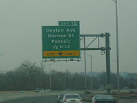
before crossing back into Passaic, where it heads farther to the west of the Passaic River, passing through industrial and residential areas of Passaic. The freeway comes to an interchange that provides access to County Route 619 (Market Street), Dayton Avenue, and Monroe Street. Route 21 continues to the north and resumes along the west bank of the Passaic River, narrowing to four lanes and crossing back into Clifton. Upon entering Clifton, the route comes to an interchange with Ackerman Avenue. The freeway heads to the northwest, passing by a park and featuring a southbound exit and northbound entrance for Lexington Avenue before ending at an interchange with U.S. Route 46
U.S. Route 46
U.S. Route 46 is an east–west U.S. Highway, running for , completely within the state of New Jersey. The west end is at an interchange with Interstate 80 and Route 94 in Columbia, Warren County on the Delaware River...
.
History
1927 New Jersey state highway renumbering
In 1927, New Jersey's state highways were renumbered. The old system, which had been defined in sequence by the legislature, was growing badly, as several routes shared the same number, and many unnumbered state highways had been defined...
to run from Route 25 (now U.S. Route 1/9) and Route 29 (now U.S. Route 22) in Newark north to Belleville. The surface portion of Route 21 in Newark, which follows the Northeast Corridor rail line, was commissioned in 1934 between Routes 25 and 29 and Market Street and the portion through downtown Newark was commissioned in 1936 between Market Street and Clay Street. In 1948, the Route 21 designation was extended north to Paterson
Paterson, New Jersey
Paterson is a city serving as the county seat of Passaic County, New Jersey, United States. As of the 2010 United States Census, its population was 146,199, rendering it New Jersey's third largest city and one of the largest cities in the New York City Metropolitan Area, despite a decrease of 3,023...
.
Plans for a freeway along the Route 21 corridor between Newark and Paterson date back to the early 1930s and became official in 1951. In 1958, the highway was extended northward as a freeway along the west bank of the Passaic River to an interchange with Park Avenue in Nutley. Route 21 was extended to the Passaic Park interchange in 1962, Main Avenue in 1968, and Monroe Street in 1973. With the completion of the freeway, a portion of the former route was briefly known as Route 21A.
The Route 21 freeway was planned to extend north to Interstate 80
Interstate 80 in New Jersey
Interstate 80 is a major Interstate Highway in the United States, running from the New York City Metropolitan Area westward to San Francisco, California...
in Elmwood Park
Elmwood Park, New Jersey
Elmwood Park is a borough in Bergen County, New Jersey, United States. As of the 2010 United States Census, the borough population was 19,403....
at the interchange with County Route 507
County Route 507 (New Jersey)
County Route 507 is a county highway in the U.S. state of New Jersey. The highway extends from Harrison Avenue on the Kearny-Harrison town line to the New York state line in Mahwah. Between Ho-Ho-Kus and Mahwah, this highway is known as Franklin Turnpike...
, crossing over the Passaic River. However, this extension was opposed by residents who lived on the east side of the Passaic River, and for a quarter-century, traffic headed for Paterson had to use local streets in Passaic. In the 1980s, plans were resurrected for completing the Route 21 freeway along the west bank of the Passaic River to U.S. Route 46 in Clifton. Official plans were made in 1996, and in late 1997, construction began on this portion of the freeway. It opened on December 20, 2000 at a cost of $136 million.
Sections of Route 21 through Newark were improved in the 1990s and the 2000s. The four-lane viaduct over the Northeast Corridor, which was built in the 1920s, was replaced between 1997 and 2003 at a cost of $43 million. In 2006, Route 21 was improved and widened to six lanes in downtown Newark, where the road passes features such as Bears and Eagles Riverfront Stadium, the New Jersey Performing Arts Center, and the Prudential Center. Despite these improvements, there are currently no plans for a freeway along the section of Route 21 through Newark.
Major intersections
| County | Location | Mile | Exit Exit number An exit number is a number assigned to a road junction, usually an exit from a freeway. It is usually marked on the same sign as the destinations of the exit, as well as a sign in the gore.... |
Destinations | Notes |
|---|---|---|---|---|---|
| Essex Essex County, New Jersey Essex County is a county located in the northeastern part of the U.S. state of New Jersey. As of the United States 2010 Census, the population was 783,969, ranking it third in the state after Bergen County and Middlesex County; Essex County's population has declined from 786,147 as of the bureau's... |
Newark Newark, New Jersey Newark is the largest city in the American state of New Jersey, and the seat of Essex County. As of the 2010 United States Census, Newark had a population of 277,140, maintaining its status as the largest municipality in New Jersey. It is the 68th largest city in the U.S... |
0.00 | Southbound exit and northbound entrance | ||
| 0.00 | Southbound exit and northbound entrance | ||||
| 0.22 | Southbound exit and northbound entrance | ||||
| 0.22 | Southbound exit and northbound entrance | ||||
| 0.76 | Broad Street | ||||
| 0.90 | North end of freeway | ||||
| 1.10 | Murray Street – Ironbound Area | ||||
| 2.21 | |||||
| 2.55 | South end of CR 508 overlap | ||||
| 2.98 | North end of CR 508 overlap | ||||
| 3.20 | |||||
|Interchange
|-
|3.37
|
|
|
|-
|3.90
|colspan=3 align="center"|South end of freeway
|-
|4.62
|4
|Chester Avenue, Riverside Avenue
|Southbound exit and northbound entrance
|-
|5.32
|5
|Grafton Avenue, Mill Street – North Newark
|Northbound exit and southbound entrance
|-
|rowspan=3|Belleville
Belleville, New Jersey
Belleville is a Township in Essex County, New Jersey, United States. As of the 2010 United States Census, the township population was 35,926.-History:...
|5.83
|5
|Mill Street – Belleville
Belleville, New Jersey
Belleville is a Township in Essex County, New Jersey, United States. As of the 2010 United States Census, the township population was 35,926.-History:...
, North Newark
|Southbound exit only
|-
|6.17
|6
|
|Northbound exit only
|-
|6.73
|7
|Main Street – Belleville
|No northbound exit
|-
|Nutley
|8.00
|8
|
|
|-
|rowspan=9|Passaic
Passaic County, New Jersey
Passaic County is a county located in the U.S. state of New Jersey. As of the 2010 Census, the population was 501,226. Its county seat is Paterson...
|rowspan=2|Clifton
Clifton, New Jersey
Clifton is a city in Passaic County, New Jersey, United States. As of the 2010 United States Census, the city had a total population of 84,136. The 2010 population represented an increase of 5,464 residents from its population of 78,672 in the 2000 Census, making it the state's 11th largest...
|9.28
|9
|
|
|-
|9.94
|10A
|
|Northbound exit and southbound entrance
|-
|rowspan=4|Passaic
Passaic, New Jersey
Passaic is a city in Passaic County, New Jersey, United States. As of the 2010 United States Census, the city had a total population of 69,781, maintaining its status as the 15th largest municipality in New Jersey with an increase of 1,920 residents from the 2000 Census population of 67,861...
|10.39
|10B
|
|Signed as exit 10 southbound
|-
|11.27
|11A
|
|Signed as exit 11 southbound
|-
|11.74
|11B
|State Street – Passaic
|Northbound exit and southbound entrance
|-
|12.60
|12
|, Dayton Avenue, Monroe Street - Passaic
|
|-
|rowspan=3|Clifton
Clifton, New Jersey
Clifton is a city in Passaic County, New Jersey, United States. As of the 2010 United States Census, the city had a total population of 84,136. The 2010 population represented an increase of 5,464 residents from its population of 78,672 in the 2000 Census, making it the state's 11th largest...
|13.52
|13
|Ackerman Avenue, Randolph Avenue – Botany Village, Garfield
Garfield, New Jersey
Garfield is a city in Bergen County, New Jersey, United States. As of the 2010 United States Census, the city population was 30,487.When the area that is now Garfield was first developed in 1873, it was known as East Passaic. In 1881, the community's name was changed to Garfield in honor of...
|
|-
|14.16
|14
|Lexington Avenue
|Southbound exit and northbound entrance
|-
|14.35
|
|
|Northbound exit and southbound entrance