
.gif)
Route 179 (New Jersey)
Encyclopedia
Pennsylvania Route 179 and Route 179 is an 8.77 miles (14.11 km) state highway
in Bucks County
, Pennsylvania
and Hunterdon County
, New Jersey
, United States
, running along an old alignment of U.S. Route 202
(US 202) from west of New Hope, Pennsylvania
northeast through Lambertville, New Jersey
to Ringoes
, where it ends at an intersection with US 202 and Route 31. Past this intersection, the road continues east as County Route 514
(CR 514). It is two-lane, undivided highway for most of its length with the exception of a four-lane stretch in Lambertville. The route crosses the Delaware River
on the New Hope-Lambertville Bridge
, where the designation changes from PA 179 to Route 179.
PA 179 and Route 179 follow a part of the 18th-century Old York Road
which ran between Philadelphia and New York City
. Prior to 1953, the road was Route S29 from the Delaware River to downtown Lambertville, a part of Route 29 between Lambertville and Ringoes, and a concurrency of Route 29 and Route 30 in Ringoes. The route was also part of US 202, which was designated over 1926-created US 122 in the mid 1930s. In 1953, the Route S29 and 29 designations were removed in favor of US 202 and Route 30 became Route 69 (now Route 31). Route 179 was formed in 1965 when a bypass for Ringoes was built for US 202 and Route 69. Route 179 extended to Lambertville and PA 179 was created in 1974 when the new US 202 freeway, running over the New Hope-Lambertville Toll Bridge
, was completed.
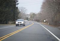
in Solebury Township
, Bucks County
, Pennsylvania
, heading east on two-lane undivided Lower York Road through commercial areas. The road crosses into New Hope
and becomes Bridge Street as it passes near a shopping center and more businesses. Farther east, the route gains a center left-turn lane and enters more residential surroundings as it passes New Hope-Solebury High School
. From this point, PA 179 loses the center left-turn lane and passes more homes. Upon crossing the New Hope and Ivyland Railroad
, the route heads into the downtown of New Hope and intersects PA 32
. PA 179 continues east to the New Hope-Lambertville Bridge
over the Delaware River
.
 At the middle of the New Hope-Lambertville bridge, the road enters Lambertville
, Hunterdon County
, New Jersey
and becomes Route 179. It heads east through Lambertville on Bridge Street through the downtown area. At the intersection with Main Street, Route 29 joins Route 179 for a block, forming a wrong-way concurrency At the end of the concurrency, Route 29 turns south onto Route 165 and Route 179 turns north. From here the road continues northeast as the four-lane, undivided Thomas Paine Highway, entering West Amwell Township
, where the road heads into farmland and narrows to two lanes. In East Amwell Township, the route intersects CR 603, CR 601, and CR 605 (Queen Road), which heads to an interchange with the US 202
freeway.
The road eventually forms the border between West Amwell and East Amwell Township
. Route 179 intersects the US 202 freeway at a partial cloverleaf interchange, where the route is entirely in East Amwell Township. Past this interchange, the route runs along the West Amwell/East Amwell township line until it entirely enters East Amwell Township again and heads into the residential community of Ringoes
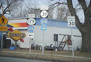
. In Ringoes, Route 179 intersects the old Route 31 (now CR 579
), forming a brief concurrency that lasts with that route until CR 579 heads north on John Ringo Road. Route 179 continues northeast through residential areas on Old York Road to its terminus at the combined US 202/Route 31, where Old York Road continues to the northeast as CR 514
.
 The current alignment of PA 179 and Route 179 was a part of Old York Road
, a historical 18th-century road that connected Philadelphia to New York City
. With the establishment of the U.S. Highway System in 1926, the route was designated as a part of US 122, which became US 202 in the mid 1930s. In Pennsylvania, the route was initially cosigned with PA 52
; that designation was removed by 1930. Prior to the 1953 New Jersey state highway renumbering
, today's Route 179 was composed of three state routes: Route S29, designated in 1949 from the New Hope-Lambertville Bridge into Lambertville, a part of Route 29 from Lambertville to Ringoes that was designated in 1927, and a concurrency
of Routes 29 and 30 northeast from Ringoes that was also designated in 1927. In the original 1927 plan, Route 29 would have continued northeast from the end of Route 179 along current CR 514, but it was instead modified to continue north with Route 30 to Flemington
and using what had been planned as Route 12 to Somerville
.
In the 1953 renumbering, the Route S29 and Route 29 designations were removed from the route in favor of US 202, with Route 29 was realigned to follow former Route 29A to Frenchtown
. In addition, Route 30 became Route 69 (now Route 31) to avoid conflicting with US 30
in South Jersey. The bypass of Ringoes for US 202 and Route 69 was opened in the 1960s, and Route 179 was designated along the old alignment of US 202 within Ringoes. The new US 202 freeway between the New Hope-Lambertville Toll Bridge
and Route 179 southwest of Ringoes was completed in October 1974. As a result, Route 179 was extended along the old US 202 alignment to the state line in Lambertville and PA 179 was designated along the former US 202 through New Hope. Solebury Township is pushing for a roundabout
at the intersection of US 202 and PA 179.
State highway
State highway, state road or state route can refer to one of three related concepts, two of them related to a state or provincial government in a country that is divided into states or provinces :#A...
in Bucks County
Bucks County, Pennsylvania
- Industry and commerce :The boroughs of Bristol and Morrisville were prominent industrial centers along the Northeast Corridor during World War II. Suburban development accelerated in Lower Bucks in the 1950s with the opening of Levittown, Pennsylvania, the second such "Levittown" designed by...
, Pennsylvania
Pennsylvania
The Commonwealth of Pennsylvania is a U.S. state that is located in the Northeastern and Mid-Atlantic regions of the United States. The state borders Delaware and Maryland to the south, West Virginia to the southwest, Ohio to the west, New York and Ontario, Canada, to the north, and New Jersey to...
and Hunterdon County
Hunterdon County, New Jersey
Hunterdon County is a county located in the western section of the U.S. state of New Jersey. As of the 2010 United States Census, the population was 128,349. It is part of the New York Metropolitan Area. Its county seat is Flemington....
, New Jersey
New Jersey
New Jersey is a state in the Northeastern and Middle Atlantic regions of the United States. , its population was 8,791,894. It is bordered on the north and east by the state of New York, on the southeast and south by the Atlantic Ocean, on the west by Pennsylvania and on the southwest by Delaware...
, United States
United States
The United States of America is a federal constitutional republic comprising fifty states and a federal district...
, running along an old alignment of U.S. Route 202
U.S. Route 202
U.S. Route 202 is a highway stretching from Delaware to Maine, also passing through the states of Pennsylvania, New Jersey, New York, Connecticut, Massachusetts, and New Hampshire....
(US 202) from west of New Hope, Pennsylvania
New Hope, Pennsylvania
New Hope, formerly known as Coryell's Ferry, is a borough in Bucks County, Pennsylvania, USA. The population was 2,528 at the 2010 census. The borough lies on the west bank of the Delaware River at its confluence with Aquetong Creek. A two-lane bridge carries automobile and foot traffic across the...
northeast through Lambertville, New Jersey
Lambertville, New Jersey
Lambertville is a city in Hunterdon County, New Jersey, United States. As of the 2010 United States Census, the city population was 3,906.Lambertville was originally incorporated as a town by an Act of the New Jersey Legislature on March 1, 1849, from portions of West Amwell Township...
to Ringoes
Ringoes, New Jersey
Ringoes is an unincorporated area located within East Amwell Township, in Hunterdon County, New Jersey. The community is served by the United States Postal Service as ZIP Code 08551. As of the United States 2000 Census, the population for ZIP Code Tabulation Area 08551 was 5,082.-History:Ringoes is...
, where it ends at an intersection with US 202 and Route 31. Past this intersection, the road continues east as County Route 514
County Route 514 (New Jersey)
County Route 514 is a county highway in the U.S. state of New Jersey. The highway extends from US 202 in East Amwell Township to Bayway Avenue in Elizabeth...
(CR 514). It is two-lane, undivided highway for most of its length with the exception of a four-lane stretch in Lambertville. The route crosses the Delaware River
Delaware River
The Delaware River is a major river on the Atlantic coast of the United States.A Dutch expedition led by Henry Hudson in 1609 first mapped the river. The river was christened the South River in the New Netherland colony that followed, in contrast to the North River, as the Hudson River was then...
on the New Hope-Lambertville Bridge
New Hope-Lambertville Bridge
The New Hope-Lambertville Bridge, officially called the New Hope-Lambertville Toll Supported Bridge, is a six-span, -long bridge spanning the Delaware River that connects the city of Lambertville in Hunterdon County, New Jersey with the borough of New Hope in Bucks County, Pennsylvania. The current...
, where the designation changes from PA 179 to Route 179.
PA 179 and Route 179 follow a part of the 18th-century Old York Road
Old York Road
Old York Road or King's Highway is a roadway that was built in the 18th century to connect Philadelphia, Pennsylvania with New York City, New York. Through New Jersey it was built along the Raritan "Naraticong Trail"...
which ran between Philadelphia and New York City
New York City
New York is the most populous city in the United States and the center of the New York Metropolitan Area, one of the most populous metropolitan areas in the world. New York exerts a significant impact upon global commerce, finance, media, art, fashion, research, technology, education, and...
. Prior to 1953, the road was Route S29 from the Delaware River to downtown Lambertville, a part of Route 29 between Lambertville and Ringoes, and a concurrency of Route 29 and Route 30 in Ringoes. The route was also part of US 202, which was designated over 1926-created US 122 in the mid 1930s. In 1953, the Route S29 and 29 designations were removed in favor of US 202 and Route 30 became Route 69 (now Route 31). Route 179 was formed in 1965 when a bypass for Ringoes was built for US 202 and Route 69. Route 179 extended to Lambertville and PA 179 was created in 1974 when the new US 202 freeway, running over the New Hope-Lambertville Toll Bridge
New Hope-Lambertville Toll Bridge
The New Hope-Lambertville Toll Bridge carries U.S. Route 202 over the Delaware River, connecting Delaware Township in Hunterdon County with Solebury Township in Bucks County. The bridge, which opened in 1971, was built and is currently operated by the Delaware River Joint Toll Bridge Commission...
, was completed.
Pennsylvania
PA 179 begins at an intersection with US 202U.S. Route 202 in Pennsylvania
U.S. Route 202 runs through the southeastern part of the U.S. state of Pennsylvania, passing through the northern and western suburbs of Philadelphia. It follows in a general southwest to northeast direction through the state, passing through West Chester, King of Prussia, Norristown,...
in Solebury Township
Solebury Township, Pennsylvania
Solebury Township is a township in Bucks County, Pennsylvania, United States. The population was 8,692 at the 2010 census.The Solebury School is located in the township, off U.S...
, Bucks County
Bucks County, Pennsylvania
- Industry and commerce :The boroughs of Bristol and Morrisville were prominent industrial centers along the Northeast Corridor during World War II. Suburban development accelerated in Lower Bucks in the 1950s with the opening of Levittown, Pennsylvania, the second such "Levittown" designed by...
, Pennsylvania
Pennsylvania
The Commonwealth of Pennsylvania is a U.S. state that is located in the Northeastern and Mid-Atlantic regions of the United States. The state borders Delaware and Maryland to the south, West Virginia to the southwest, Ohio to the west, New York and Ontario, Canada, to the north, and New Jersey to...
, heading east on two-lane undivided Lower York Road through commercial areas. The road crosses into New Hope
New Hope, Pennsylvania
New Hope, formerly known as Coryell's Ferry, is a borough in Bucks County, Pennsylvania, USA. The population was 2,528 at the 2010 census. The borough lies on the west bank of the Delaware River at its confluence with Aquetong Creek. A two-lane bridge carries automobile and foot traffic across the...
and becomes Bridge Street as it passes near a shopping center and more businesses. Farther east, the route gains a center left-turn lane and enters more residential surroundings as it passes New Hope-Solebury High School
New Hope-Solebury High School
New Hope-Solebury High School is a high school located at 182 West Bridge Street in New Hope, Pennsylvania. The school's mascot is the Lion, and its colors are blue and gold. It is located in the New Hope-Solebury School District. The school houses grades 9 through 12. The school has approximately...
. From this point, PA 179 loses the center left-turn lane and passes more homes. Upon crossing the New Hope and Ivyland Railroad
New Hope and Ivyland Railroad
The New Hope and Ivyland Railroad is a shortline railroad in Pennsylvania. It also operates a heritage railroad, offering passenger excursions....
, the route heads into the downtown of New Hope and intersects PA 32
Pennsylvania Route 32
Pennsylvania Route 32 is a scenic two-lane highway that runs along the side of the Delaware River in Bucks County, Pennsylvania. It begins at U.S. 1 in Falls Township and ends at Pennsylvania Route 611 near the village of Kintnersville...
. PA 179 continues east to the New Hope-Lambertville Bridge
New Hope-Lambertville Bridge
The New Hope-Lambertville Bridge, officially called the New Hope-Lambertville Toll Supported Bridge, is a six-span, -long bridge spanning the Delaware River that connects the city of Lambertville in Hunterdon County, New Jersey with the borough of New Hope in Bucks County, Pennsylvania. The current...
over the Delaware River
Delaware River
The Delaware River is a major river on the Atlantic coast of the United States.A Dutch expedition led by Henry Hudson in 1609 first mapped the river. The river was christened the South River in the New Netherland colony that followed, in contrast to the North River, as the Hudson River was then...
.
New Jersey
Lambertville, New Jersey
Lambertville is a city in Hunterdon County, New Jersey, United States. As of the 2010 United States Census, the city population was 3,906.Lambertville was originally incorporated as a town by an Act of the New Jersey Legislature on March 1, 1849, from portions of West Amwell Township...
, Hunterdon County
Hunterdon County, New Jersey
Hunterdon County is a county located in the western section of the U.S. state of New Jersey. As of the 2010 United States Census, the population was 128,349. It is part of the New York Metropolitan Area. Its county seat is Flemington....
, New Jersey
New Jersey
New Jersey is a state in the Northeastern and Middle Atlantic regions of the United States. , its population was 8,791,894. It is bordered on the north and east by the state of New York, on the southeast and south by the Atlantic Ocean, on the west by Pennsylvania and on the southwest by Delaware...
and becomes Route 179. It heads east through Lambertville on Bridge Street through the downtown area. At the intersection with Main Street, Route 29 joins Route 179 for a block, forming a wrong-way concurrency At the end of the concurrency, Route 29 turns south onto Route 165 and Route 179 turns north. From here the road continues northeast as the four-lane, undivided Thomas Paine Highway, entering West Amwell Township
West Amwell Township, New Jersey
The Delaware River separates West Amwell from the Commonwealth of Pennsylvania.-Demographics:As of the census of 2000, there were 2,383 people, 949 households, and 696 families residing in the township. The population density was 109.7 people per square mile . There were 984 housing units at an...
, where the road heads into farmland and narrows to two lanes. In East Amwell Township, the route intersects CR 603, CR 601, and CR 605 (Queen Road), which heads to an interchange with the US 202
U.S. Route 202 in New Jersey
U.S. Route 202 is a U.S. Highway running from New Castle, Delaware northeast to Bangor, Maine. In the U.S. state of New Jersey, the route runs from the New Hope-Lambertville Toll Bridge over the Delaware River at the Pennsylvania border in Delaware Township, Hunterdon County near Lambertville...
freeway.
The road eventually forms the border between West Amwell and East Amwell Township
East Amwell Township, New Jersey
-History:During the American Revolutionary War, a small but important skirmish occurred in East Amwell when local militia under Capt. John Schenck ambushed a party of British dragoons near Larison's Corner...
. Route 179 intersects the US 202 freeway at a partial cloverleaf interchange, where the route is entirely in East Amwell Township. Past this interchange, the route runs along the West Amwell/East Amwell township line until it entirely enters East Amwell Township again and heads into the residential community of Ringoes
Ringoes, New Jersey
Ringoes is an unincorporated area located within East Amwell Township, in Hunterdon County, New Jersey. The community is served by the United States Postal Service as ZIP Code 08551. As of the United States 2000 Census, the population for ZIP Code Tabulation Area 08551 was 5,082.-History:Ringoes is...
. In Ringoes, Route 179 intersects the old Route 31 (now CR 579
County Route 579 (New Jersey)
County Route 579, abbreviated CR 579, is a county highway in the U.S. state of New Jersey. The highway extends from John Fitch Parkway in Trenton to Route 173 in Greenwich Township.-Mercer County:...
), forming a brief concurrency that lasts with that route until CR 579 heads north on John Ringo Road. Route 179 continues northeast through residential areas on Old York Road to its terminus at the combined US 202/Route 31, where Old York Road continues to the northeast as CR 514
County Route 514 (New Jersey)
County Route 514 is a county highway in the U.S. state of New Jersey. The highway extends from US 202 in East Amwell Township to Bayway Avenue in Elizabeth...
.
History
Old York Road
Old York Road or King's Highway is a roadway that was built in the 18th century to connect Philadelphia, Pennsylvania with New York City, New York. Through New Jersey it was built along the Raritan "Naraticong Trail"...
, a historical 18th-century road that connected Philadelphia to New York City
New York City
New York is the most populous city in the United States and the center of the New York Metropolitan Area, one of the most populous metropolitan areas in the world. New York exerts a significant impact upon global commerce, finance, media, art, fashion, research, technology, education, and...
. With the establishment of the U.S. Highway System in 1926, the route was designated as a part of US 122, which became US 202 in the mid 1930s. In Pennsylvania, the route was initially cosigned with PA 52
Pennsylvania Route 52
Pennsylvania Route 52 is a long state highway located in southeast Pennsylvania. The southern terminus of the route is at the Pennsylvania-Delaware state line near Kennett Square, where PA 52 continues as Delaware Route 52. The northern terminus is at U.S. Route 322 Business in West Chester. Near...
; that designation was removed by 1930. Prior to the 1953 New Jersey state highway renumbering
1953 New Jersey state highway renumbering
On January 1, 1953, the New Jersey Department of Transportation renumbered many of the State Routes. A few rules were followed in deciding what to renumber:...
, today's Route 179 was composed of three state routes: Route S29, designated in 1949 from the New Hope-Lambertville Bridge into Lambertville, a part of Route 29 from Lambertville to Ringoes that was designated in 1927, and a concurrency
Concurrency (road)
A concurrency, overlap, or coincidence in a road network is an instance of one physical road bearing two or more different highway, motorway, or other route numbers...
of Routes 29 and 30 northeast from Ringoes that was also designated in 1927. In the original 1927 plan, Route 29 would have continued northeast from the end of Route 179 along current CR 514, but it was instead modified to continue north with Route 30 to Flemington
Flemington, New Jersey
Flemington is a borough in Hunterdon County, New Jersey, United States. As of the United States 2010 Census, the borough population was 4,581. It is the county seat of Hunterdon County....
and using what had been planned as Route 12 to Somerville
Somerville, New Jersey
Somerville is a borough in Somerset County, New Jersey, United States. As of the 2010 United States Census, the borough population was 12,098. It is the county seat of Somerset County....
.
In the 1953 renumbering, the Route S29 and Route 29 designations were removed from the route in favor of US 202, with Route 29 was realigned to follow former Route 29A to Frenchtown
Frenchtown, New Jersey
Frenchtown is a Borough in Hunterdon County, New Jersey, United States. As of the United States 2010 Census, the borough population was 1,373....
. In addition, Route 30 became Route 69 (now Route 31) to avoid conflicting with US 30
U.S. Route 30 in New Jersey
U.S. Route 30 is a U.S. highway running from Astoria, Oregon east to Atlantic City, New Jersey. In the U.S. state of New Jersey, US 30 runs from the Benjamin Franklin Bridge at the Delaware River in Camden, Camden County while concurrent with Interstate 676 southeast to Virginia...
in South Jersey. The bypass of Ringoes for US 202 and Route 69 was opened in the 1960s, and Route 179 was designated along the old alignment of US 202 within Ringoes. The new US 202 freeway between the New Hope-Lambertville Toll Bridge
New Hope-Lambertville Toll Bridge
The New Hope-Lambertville Toll Bridge carries U.S. Route 202 over the Delaware River, connecting Delaware Township in Hunterdon County with Solebury Township in Bucks County. The bridge, which opened in 1971, was built and is currently operated by the Delaware River Joint Toll Bridge Commission...
and Route 179 southwest of Ringoes was completed in October 1974. As a result, Route 179 was extended along the old US 202 alignment to the state line in Lambertville and PA 179 was designated along the former US 202 through New Hope. Solebury Township is pushing for a roundabout
Roundabout
A roundabout is the name for a road junction in which traffic moves in one direction around a central island. The word dates from the early 20th century. Roundabouts are common in many countries around the world...
at the intersection of US 202 and PA 179.