
.gif)
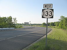
Route 133 (New Jersey)
Encyclopedia
Route 133 is a major state freeway
located entirely in East Windsor Township
, Mercer County
, New Jersey
. The route runs as a 3.59 miles (5.8 km) long four-lane bypass of Hightstown
from County Route 571
at Windsor Center to the four-lane New Jersey Route 33 east of Hightstown. The bypass connects the two highways with the New Jersey Turnpike
(Interstate 95
) at exit 8, west around the north side of Hightstown and U.S. Route 130
. Although Route 133 is a freeway, it has no direct connections to any other freeways as the connection to the Turnpike at Route 33 leads through several traffic lights.
The plans for the original bypass of Hightstown originated in 1929, when locals looked for a way to remove traffic from downtown. The New Jersey State Legislature followed up in 1938 by designating a new spur off of State Highway Route 31
, State Highway Route 31A as a freeway from Princeton
to the Jersey Shore
. During the 1970s, Route 92 gained momentum, running from Princeton (at Interstate 95's proposed Somerset Freeway) all the way to Route 33 at Hightstown. However, after several setbacks, Route 92 was moved northward in 1988 and the bypass was truncated to a short portion of highway bypassing Hightstown. Construction on the new $57 million USD Route 133 commenced on September 20, 1996 by Schiavone Construction Company and was completed and opened on November 30, 1999.
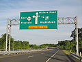 Route 133 begins at an at-grade intersection with County Route 571
(Hightstown Road) in the community of East Windsor
. The intersection includes a jughandle for eastbound traffic to use to access the highway. After the jughandle on Windsor Center Drive, Route 133 begins to progress its way northward as a four-lane freeway, crossing through surroundings of trees and open fields. Along a large bend, the highway turns eastward, paralleling to County Route 571 to the south and County Route 535
(Old Trenton Road) to the north. Passing to the southeast of a factory, Route 133 curves to the southeast through fields and crosses over the locally-maintained One Mile Road heading eastbound and interchanges westbound. Heading eastbound, the on-ramp to Route 133 from One Mile Road merges in, and the highway continues, passing to the north of homes and commercial buildings through East Windsor.
 A short distance later, Route 133 develops a wide median as it crosses on a bridge over a river. After crossing the river, the highway's surroundings change drastically, with residential homes surrounding the freeway in each direction. A short distance later, Route 133 crosses over U.S. Route 130
's six-lane alignment, reaching an interchange with the northbound lanes after crossing. After Route 130, the highway continues eastward, crossing over County Route 539
(North Main Street). The highway crosses the right of way of the historic Camden & Amboy railroad; there is no bridge over the trackbed that is abandoned only a short few feet to the north and a few miles south around the Hightstown area. After crossing Route 539, Route 133 turns to the southeast once again, continuing to the south of the condominium complex. Leaving the condos behind, the highway turns southward through lands and paralleling to the south of Cranbury Station Road. Route 133 continues southward, crossing over Wyckoff Mills Road, which serves as the southern terminus of Cranbury Station Road. Now paralleling Wyckoff Mills Road, the four-lane freeway continues eastward, crossing over the six lanes of the New Jersey Turnpike
(Interstate 95
). The Route 133 bridge over the Turnpike was already built with the considerations the New Jersey Turnpike would be widened an extra lane in each direction, which is occurring now. Continuing to the south of Wyckoffs Mill Road, Route 133 passes through northern Mercer County as a four-lane freeway. Soon after, Route 133 turns southward, heading away from Wyckoffs Mill and intersecting at-grade with Route 33, where the designation terminates.
eastward to Hightstown and further to the Atlantic Ocean
along current-day Route 33. In 1950, governor
Alfred E. Driscoll
exercised the need for the state-wide expressway, citing that "it is unwise to expect city streets to bear the brunt of through, truck and passenger traffic." However, State Highway Route 31A was decommissioned in the 1953 state highway renumbering
to a short portion of highway in West Windsor as Route 64.
During the 1950s, the New Jersey State Highway Department released plans to construct the Princeton–Hightstown Bypass, a 14 miles (22.5 km) long, four-lane freeway connecting U.S. Route 206
in the Montgomery Township
community of Skillman
to Route 33 in East Windsor Township. The freeway, designated as Route 92, was to connect US 206 with Route 27, U.S. Route 1
, and US 130, Route 33 and the New Jersey Turnpike. While the eastern terminus was to be at the New Jersey Turnpike, the western terminus of Route 92 was to be at an interchange with the Somerset Freeway (Interstate 95) near Rocky Hill. Although plans for Route 92 remained, the Somerset Freeway proposal was decommissioned in 1982, leaving open funds for use on other projects. The New Jersey Department of Transportation
suggested serving funds to the Route 92 project along with five other transportation projects. The project was working on its final studies and proposals in 1986, which was the year new interstates could be proposed to the Federal Highway Administration
, however, the portion west of U.S. Route 1 was dropped from the plans a year later.
 After Route 92 was shifted northward by the New Jersey Department of Transportation
due to the belief that it would better serve residents further north, the proposal went into shadows. In 1994, six years after plans changed for the Route 92 Freeway, the Department of Transportation revived the plans, attempting to build the freeway from Princeton to Hightstown. However, the next year, the plan had to be altered due to public opposition from the communities of Princeton and Plainsboro. This plan was to construct a 3.8 miles (6.1 km) bypass of Hightstown and East Windsor, now designated as Route 133. The bid for the construction of the new four-lane freeway was accepted from the Schiavone Construction Company in 1996 for a cost of $57 million (1996 USD). Design began that June and construction of the new Freeway started on September 20. The project was constructed as New Jersey's first Modified-Design Build freeway, which helped save money and costs for construction, reducing 26 months off the average construction time for the style of freeway. On November 30, 1999, the roadway, which was completed, was opened to commuter traffic, over a year later than originally estimated (July 1998). Part of this delay was due to the events of Hurricane Floyd
during September 1999, when much of the area fell victim to substantial erosion.
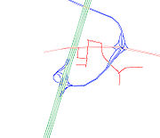 On December 31, 2006, the New Jersey Turnpike Authority
released its proposals regarding Interchange 8 of the New Jersey Turnpike and its possible replacement. The current Interchange 8 would be demolished and replaced with a new interchange. The new Exit 8 would end at the intersection with Route 33, Milford Road, and the Route 133 bypass (on the east side of the expressway, instead of the west). This new Exit 8 would grant direct access to the bypass (without going through any traffic lights), as well as to Route 33, using grade-separated interchanges. The new toll gate would feature a total of 12 booths at the toll gate. The second option would be a grade-separated diamond interchange
would be constructed, which would lead the ramps towards Route 33. At the intersection with Route 33 and the interchange ramps (from the turnpike and 133), a traffic signal would be built underneath Exit 8 ramps/Route 133. In lieu of a connector road, a jughandle
would be built on Route 33 west. This would intersect at Route 33 (with a traffic light) and become the relocated Milford Road (after crossing Route 33).
The third option was an unusual cloverleaf interchange would be built in lieu of a diamond interchange. After exiting the turnpike from the 8 toll gate, a ramp on the right would lead to Milford Road or Route 33. The mainline of the turnpike ramp would cross over 33 and turn into the Route 133 bypass. A relocated Milford Road would be built across from Monmouth Street & Route 33 (without connecting Monmouth and Milford) towards the intersection with the current Milford Road and Daniel Street. The new Milford would cross over the turnpike ramps. A leaf would be built from the turnpike ramp approaching the Exit 8 toll gate, which would connect to Milford Road. An entrance ramp would be constructed from Milford Road to the Exit 8 toll gate. Traveling north on Milford Road, a ramp would be constructed, which would diverge into two ways; one way would merge into the turnpike ramp heading towards Route 133, and the other would intersect at a new traffic light at Route 33, 0.1 mile (0.160934 km) east of the current Route 33/133/Milford Road intersection.
Ultimately, the Turnpike Authority chose the first option for the interchange.
State highway
State highway, state road or state route can refer to one of three related concepts, two of them related to a state or provincial government in a country that is divided into states or provinces :#A...
located entirely in East Windsor Township
East Windsor Township, New Jersey
-Demographics:As of the census of 2000, there were 24,919 people, 9,448 households, and 6,556 families residing in the township. The population density was 1,592.8 people per square mile . There were 9,880 housing units at an average density of 631.5 per square mile...
, Mercer County
Mercer County, New Jersey
As of the census of 2000, there were 350,761 people, 125,807 households, and 86,303 families residing in the county. The population density was 1,552 people per square mile . There were 133,280 housing units at an average density of 590 per square mile...
, New Jersey
New Jersey
New Jersey is a state in the Northeastern and Middle Atlantic regions of the United States. , its population was 8,791,894. It is bordered on the north and east by the state of New York, on the southeast and south by the Atlantic Ocean, on the west by Pennsylvania and on the southwest by Delaware...
. The route runs as a 3.59 miles (5.8 km) long four-lane bypass of Hightstown
Hightstown, New Jersey
Hightstown is a Borough in Mercer County, New Jersey, United States. As of the 2010 United States Census, the borough population was 5,494.Hightstown was incorporated as a borough by an Act of the New Jersey Legislature on March 5, 1853, within portions of East Windsor Township. The borough became...
from County Route 571
County Route 571 (New Jersey)
County Route 571, abbreviated CR 571, is a county highway in the U.S. state of New Jersey. The highway extends from Route 37 in Toms River Township to Route 27 in the Borough of Princeton.-Ocean County:...
at Windsor Center to the four-lane New Jersey Route 33 east of Hightstown. The bypass connects the two highways with the New Jersey Turnpike
New Jersey Turnpike
The New Jersey Turnpike is a toll road in New Jersey, maintained by the New Jersey Turnpike Authority. According to the International Bridge, Tunnel and Turnpike Association, the Turnpike is the nation's sixth-busiest toll road and is among one of the most heavily traveled highways in the United...
(Interstate 95
Interstate 95 in New Jersey
Interstate 95 is a major Interstate Highway that traverses the full extent of the East Coast of the United States, from Florida to Maine...
) at exit 8, west around the north side of Hightstown and U.S. Route 130
U.S. Route 130
U.S. Route 130 is a north–south U.S. Highway completely within the state of New Jersey. It runs from Interstate 295 and US 40 at Deepwater in Pennsville Township, Salem County, where the road continues east as Route 49, north to US 1 in North Brunswick Township, Middlesex County, where...
. Although Route 133 is a freeway, it has no direct connections to any other freeways as the connection to the Turnpike at Route 33 leads through several traffic lights.
The plans for the original bypass of Hightstown originated in 1929, when locals looked for a way to remove traffic from downtown. The New Jersey State Legislature followed up in 1938 by designating a new spur off of State Highway Route 31
U.S. Route 206
U.S. Route 206 is a long north–south United States highway in New Jersey and Pennsylvania, United States. Only about a half a mile of its length is in Pennsylvania; the Milford-Montague Toll Bridge carries it over the Delaware River into New Jersey, where it is the remainder of the route...
, State Highway Route 31A as a freeway from Princeton
Princeton, New Jersey
Princeton is a community located in Mercer County, New Jersey, United States. It is best known as the location of Princeton University, which has been sited in the community since 1756...
to the Jersey Shore
Jersey Shore
The Jersey Shore is a term used to refer to both the Atlantic coast of the U.S. state of New Jersey and the adjacent resort and residential communities. . The New Jersey State Department of Tourism considers the Shore Region, Greater Atlantic City, and the Southern Shore to be distinct, each having...
. During the 1970s, Route 92 gained momentum, running from Princeton (at Interstate 95's proposed Somerset Freeway) all the way to Route 33 at Hightstown. However, after several setbacks, Route 92 was moved northward in 1988 and the bypass was truncated to a short portion of highway bypassing Hightstown. Construction on the new $57 million USD Route 133 commenced on September 20, 1996 by Schiavone Construction Company and was completed and opened on November 30, 1999.
Route description
County Route 571 (New Jersey)
County Route 571, abbreviated CR 571, is a county highway in the U.S. state of New Jersey. The highway extends from Route 37 in Toms River Township to Route 27 in the Borough of Princeton.-Ocean County:...
(Hightstown Road) in the community of East Windsor
East Windsor Township, New Jersey
-Demographics:As of the census of 2000, there were 24,919 people, 9,448 households, and 6,556 families residing in the township. The population density was 1,592.8 people per square mile . There were 9,880 housing units at an average density of 631.5 per square mile...
. The intersection includes a jughandle for eastbound traffic to use to access the highway. After the jughandle on Windsor Center Drive, Route 133 begins to progress its way northward as a four-lane freeway, crossing through surroundings of trees and open fields. Along a large bend, the highway turns eastward, paralleling to County Route 571 to the south and County Route 535
County Route 535 (New Jersey)
County Route 535 is a county highway in the U.S. state of New Jersey. The highway extends from Logan Avenue , at the boundary between Trenton and Hamilton Township in Mercer County to the intersection of Main Street, Raritan Street and Washington Road in Sayreville in Middlesex County.The road...
(Old Trenton Road) to the north. Passing to the southeast of a factory, Route 133 curves to the southeast through fields and crosses over the locally-maintained One Mile Road heading eastbound and interchanges westbound. Heading eastbound, the on-ramp to Route 133 from One Mile Road merges in, and the highway continues, passing to the north of homes and commercial buildings through East Windsor.
U.S. Route 130
U.S. Route 130 is a north–south U.S. Highway completely within the state of New Jersey. It runs from Interstate 295 and US 40 at Deepwater in Pennsville Township, Salem County, where the road continues east as Route 49, north to US 1 in North Brunswick Township, Middlesex County, where...
's six-lane alignment, reaching an interchange with the northbound lanes after crossing. After Route 130, the highway continues eastward, crossing over County Route 539
County Route 539 (New Jersey)
County Route 539, abbreviated CR 539, is a county highway in the U.S. state of New Jersey. The highway extends from Main Street in Tuckerton to U.S. Route 130 in Cranbury Township. However, signage on CR 539 suggests that it crosses U.S...
(North Main Street). The highway crosses the right of way of the historic Camden & Amboy railroad; there is no bridge over the trackbed that is abandoned only a short few feet to the north and a few miles south around the Hightstown area. After crossing Route 539, Route 133 turns to the southeast once again, continuing to the south of the condominium complex. Leaving the condos behind, the highway turns southward through lands and paralleling to the south of Cranbury Station Road. Route 133 continues southward, crossing over Wyckoff Mills Road, which serves as the southern terminus of Cranbury Station Road. Now paralleling Wyckoff Mills Road, the four-lane freeway continues eastward, crossing over the six lanes of the New Jersey Turnpike
New Jersey Turnpike
The New Jersey Turnpike is a toll road in New Jersey, maintained by the New Jersey Turnpike Authority. According to the International Bridge, Tunnel and Turnpike Association, the Turnpike is the nation's sixth-busiest toll road and is among one of the most heavily traveled highways in the United...
(Interstate 95
Interstate 95 in New Jersey
Interstate 95 is a major Interstate Highway that traverses the full extent of the East Coast of the United States, from Florida to Maine...
). The Route 133 bridge over the Turnpike was already built with the considerations the New Jersey Turnpike would be widened an extra lane in each direction, which is occurring now. Continuing to the south of Wyckoffs Mill Road, Route 133 passes through northern Mercer County as a four-lane freeway. Soon after, Route 133 turns southward, heading away from Wyckoffs Mill and intersecting at-grade with Route 33, where the designation terminates.
State Route 92, the original proposal
The original conception for a bypass of Hightstown date back to 1929, when local members of community brought up the thought for a solution to relieve traffic on current-day County Route 571 away from the downtown. However, nothing was ever produced, until 1938, when the New Jersey State Legislature brought forth the designation of State Highway Route 31A, a modern expressway crossing from the borough of PrincetonPrinceton, New Jersey
Princeton is a community located in Mercer County, New Jersey, United States. It is best known as the location of Princeton University, which has been sited in the community since 1756...
eastward to Hightstown and further to the Atlantic Ocean
Atlantic Ocean
The Atlantic Ocean is the second-largest of the world's oceanic divisions. With a total area of about , it covers approximately 20% of the Earth's surface and about 26% of its water surface area...
along current-day Route 33. In 1950, governor
Governor of New Jersey
The Office of the Governor of New Jersey is the executive branch for the U.S. state of New Jersey. The office of Governor is an elected position, for which elected officials serve four year terms. While individual politicians may serve as many terms as they can be elected to, Governors cannot be...
Alfred E. Driscoll
Alfred E. Driscoll
Alfred Eastlack Driscoll was an American Republican Party politician, who served in the New Jersey Senate representing Camden County, who served as the 43rd Governor of New Jersey, and as president of Warner-Lambert .-Biography:He was born on October 25, 1902 in Pittsburgh, Pennsylvania...
exercised the need for the state-wide expressway, citing that "it is unwise to expect city streets to bear the brunt of through, truck and passenger traffic." However, State Highway Route 31A was decommissioned in the 1953 state highway renumbering
1953 New Jersey state highway renumbering
On January 1, 1953, the New Jersey Department of Transportation renumbered many of the State Routes. A few rules were followed in deciding what to renumber:...
to a short portion of highway in West Windsor as Route 64.
During the 1950s, the New Jersey State Highway Department released plans to construct the Princeton–Hightstown Bypass, a 14 miles (22.5 km) long, four-lane freeway connecting U.S. Route 206
U.S. Route 206
U.S. Route 206 is a long north–south United States highway in New Jersey and Pennsylvania, United States. Only about a half a mile of its length is in Pennsylvania; the Milford-Montague Toll Bridge carries it over the Delaware River into New Jersey, where it is the remainder of the route...
in the Montgomery Township
Montgomery Township, New Jersey
Montgomery Township is a Township in Somerset County, New Jersey, United States. As of the United States 2010 Census, the township population was 22,254, which represents growth of 27% since 2000 and more than 130% since the 1990 Census population figure of 9,612.Montgomery Township was...
community of Skillman
Skillman, New Jersey
Skillman is an unincorporated area within Montgomery Township in Somerset County, New Jersey, United States. The area is served as United States Postal Service ZIP Code 08558. It is also home to Johnson and Johnson's consumer division.- History :...
to Route 33 in East Windsor Township. The freeway, designated as Route 92, was to connect US 206 with Route 27, U.S. Route 1
U.S. Route 1 in New Jersey
U.S. Route 1 is a United States highway which parallels the East Coast of the United States, running from Key West, Florida in the south to Fort Kent, Maine at the Canadian border in the north. Of the entire length of the route, of it runs through New Jersey...
, and US 130, Route 33 and the New Jersey Turnpike. While the eastern terminus was to be at the New Jersey Turnpike, the western terminus of Route 92 was to be at an interchange with the Somerset Freeway (Interstate 95) near Rocky Hill. Although plans for Route 92 remained, the Somerset Freeway proposal was decommissioned in 1982, leaving open funds for use on other projects. The New Jersey Department of Transportation
New Jersey Department of Transportation
The New Jersey Department of Transportation is the agency responsible for transportation issues and policy in New Jersey. It is headed by the Commissioner of Transportation...
suggested serving funds to the Route 92 project along with five other transportation projects. The project was working on its final studies and proposals in 1986, which was the year new interstates could be proposed to the Federal Highway Administration
Federal Highway Administration
The Federal Highway Administration is a division of the United States Department of Transportation that specializes in highway transportation. The agency's major activities are grouped into two "programs," the Federal-aid Highway Program and the Federal Lands Highway Program...
, however, the portion west of U.S. Route 1 was dropped from the plans a year later.
The down-scaled Route 133
New Jersey Department of Transportation
The New Jersey Department of Transportation is the agency responsible for transportation issues and policy in New Jersey. It is headed by the Commissioner of Transportation...
due to the belief that it would better serve residents further north, the proposal went into shadows. In 1994, six years after plans changed for the Route 92 Freeway, the Department of Transportation revived the plans, attempting to build the freeway from Princeton to Hightstown. However, the next year, the plan had to be altered due to public opposition from the communities of Princeton and Plainsboro. This plan was to construct a 3.8 miles (6.1 km) bypass of Hightstown and East Windsor, now designated as Route 133. The bid for the construction of the new four-lane freeway was accepted from the Schiavone Construction Company in 1996 for a cost of $57 million (1996 USD). Design began that June and construction of the new Freeway started on September 20. The project was constructed as New Jersey's first Modified-Design Build freeway, which helped save money and costs for construction, reducing 26 months off the average construction time for the style of freeway. On November 30, 1999, the roadway, which was completed, was opened to commuter traffic, over a year later than originally estimated (July 1998). Part of this delay was due to the events of Hurricane Floyd
Hurricane Floyd
Hurricane Floyd was the sixth named storm, fourth hurricane, and third major hurricane in the 1999 Atlantic hurricane season. Floyd triggered the third largest evacuation in US history when 2.6 million coastal residents of five states were ordered from their homes as it approached...
during September 1999, when much of the area fell victim to substantial erosion.
Future
New Jersey Turnpike
The New Jersey Turnpike is a toll road in New Jersey, maintained by the New Jersey Turnpike Authority. According to the International Bridge, Tunnel and Turnpike Association, the Turnpike is the nation's sixth-busiest toll road and is among one of the most heavily traveled highways in the United...
released its proposals regarding Interchange 8 of the New Jersey Turnpike and its possible replacement. The current Interchange 8 would be demolished and replaced with a new interchange. The new Exit 8 would end at the intersection with Route 33, Milford Road, and the Route 133 bypass (on the east side of the expressway, instead of the west). This new Exit 8 would grant direct access to the bypass (without going through any traffic lights), as well as to Route 33, using grade-separated interchanges. The new toll gate would feature a total of 12 booths at the toll gate. The second option would be a grade-separated diamond interchange
Diamond interchange
A diamond interchange is a common type of road junction, used where a freeway crosses a minor road. The freeway itself is grade-separated from the minor road, one crossing the other over a bridge...
would be constructed, which would lead the ramps towards Route 33. At the intersection with Route 33 and the interchange ramps (from the turnpike and 133), a traffic signal would be built underneath Exit 8 ramps/Route 133. In lieu of a connector road, a jughandle
Jughandle
A jughandle is a type of ramp or slip road that changes the way traffic turns left at at-grade intersections. Instead of a standard left turn being made from the left lane, left-turning traffic uses a ramp on the right side of the road...
would be built on Route 33 west. This would intersect at Route 33 (with a traffic light) and become the relocated Milford Road (after crossing Route 33).
The third option was an unusual cloverleaf interchange would be built in lieu of a diamond interchange. After exiting the turnpike from the 8 toll gate, a ramp on the right would lead to Milford Road or Route 33. The mainline of the turnpike ramp would cross over 33 and turn into the Route 133 bypass. A relocated Milford Road would be built across from Monmouth Street & Route 33 (without connecting Monmouth and Milford) towards the intersection with the current Milford Road and Daniel Street. The new Milford would cross over the turnpike ramps. A leaf would be built from the turnpike ramp approaching the Exit 8 toll gate, which would connect to Milford Road. An entrance ramp would be constructed from Milford Road to the Exit 8 toll gate. Traveling north on Milford Road, a ramp would be constructed, which would diverge into two ways; one way would merge into the turnpike ramp heading towards Route 133, and the other would intersect at a new traffic light at Route 33, 0.1 mile (0.160934 km) east of the current Route 33/133/Milford Road intersection.
Ultimately, the Turnpike Authority chose the first option for the interchange.
Exit list
See also
- County Route 522County Route 522 (New Jersey)County Route 522 is a county highway in the U.S. state of New Jersey. The highway extends from U.S. 1 in South Brunswick Township to Main Street in Freehold Borough.-Middlesex County:...
, a four-lane road from U.S. Route 130U.S. Route 130U.S. Route 130 is a north–south U.S. Highway completely within the state of New Jersey. It runs from Interstate 295 and US 40 at Deepwater in Pennsville Township, Salem County, where the road continues east as Route 49, north to US 1 in North Brunswick Township, Middlesex County, where...
west to U.S. Route 1U.S. Route 1 in New JerseyU.S. Route 1 is a United States highway which parallels the East Coast of the United States, running from Key West, Florida in the south to Fort Kent, Maine at the Canadian border in the north. Of the entire length of the route, of it runs through New Jersey...
in the same general corridor as Route 92