
Rother
Encyclopedia
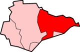
Rother is a local government district
in East Sussex
, England
. The district is named after the River Rother
which flows within its boundaries.
, by the merger of the Municipal Borough of Bexhill
, the Municipal Borough of Rye
and Battle Rural District. It is one of three districts within the county without borough
status and is the easternmost one: the other two being Lewes
to the west, and Wealden
in the centre. The Borough of Hastings
lies surrounded by Rother.
.
The district is second-level in local government. There are 38 members of the Council, representing 20 wards. Bexhill has nine wards: the remaining councillors represent the other 29 wards.
The lowest level of local government is the civil parish: there are 29 within the Rother District which are:
Playden and East Guldeford are merged in the statistical analysis although they are both civil parishes in their own right. Playden has a Parish Council whilst East Guldeford holds a Parish Meeting.
; and to the north the lower land, named the Rother Levels, across which flow the River Rother, which rises on the Weald and flows easterly towards Rye Bay, and its tributaries. For much of the course of the main river it constitutes the boundary between East Sussex and Kent
, and is given the alternative title of the ’’Kent Ditch’’. Tributaries of the river include the Rivers Dudwell, Tillingham
and Brede
.
The district reaches the coast in the vicinity of Bexhill, and on the shores of Rye Bay.
road from Ashford road near Hastings; which in turn is crossed by the A268 Hawkhurst
to Rye road. There is also the A259
coastal route
The Hastings Line
, East Coastway Line
and the Marshlink Line
are the three railway lines in the District; The Kent and East Sussex Railway
tourist line terminates at Bodiam.
Long-distance footpaths include the Sussex Border Path
; and the Saxon Shore Way
, which links with the 1066 Country Walk
.
and Camber Castle
s; and Battle Abbey
.
Non-metropolitan district
Non-metropolitan districts, or colloquially shire districts, are a type of local government district in England. As created, they are sub-divisions of non-metropolitan counties in a so-called "two-tier" arrangement...
in East Sussex
East Sussex
East Sussex is a county in South East England. It is bordered by the counties of Kent, Surrey and West Sussex, and to the south by the English Channel.-History:...
, England
England
England is a country that is part of the United Kingdom. It shares land borders with Scotland to the north and Wales to the west; the Irish Sea is to the north west, the Celtic Sea to the south west, with the North Sea to the east and the English Channel to the south separating it from continental...
. The district is named after the River Rother
River Rother (Eastern)
The River Rother , at 35 miles , is a river flowing through both East Sussex and Kent, England. Its source is near Rotherfield , and its mouth is on Rye Bay, part of the English Channel....
which flows within its boundaries.
History
The District of Rother was formed on 1 April 1974, under the Local Government Act 1972Local Government Act 1972
The Local Government Act 1972 is an Act of Parliament in the United Kingdom that reformed local government in England and Wales on 1 April 1974....
, by the merger of the Municipal Borough of Bexhill
Bexhill-on-Sea
Bexhill-on-Sea is a town and seaside resort in the county of East Sussex, in the south of England, within the District of Rother. It has a population of approximately 40,000...
, the Municipal Borough of Rye
Rye, East Sussex
Rye is a small town in East Sussex, England, which stands approximately two miles from the open sea and is at the confluence of three rivers: the Rother, the Tillingham and the Brede...
and Battle Rural District. It is one of three districts within the county without borough
Borough
A borough is an administrative division in various countries. In principle, the term borough designates a self-governing township although, in practice, official use of the term varies widely....
status and is the easternmost one: the other two being Lewes
Lewes (district)
Lewes is a local government district in East Sussex in southern England covering an area of , with of coastline. It is named after its administrative centre, Lewes. Other towns in the district include Newhaven, Peacehaven, and Seaford. Plumpton racecourse is within the district...
to the west, and Wealden
Wealden
For the stone, see Wealden GroupWealden is a local government district in East Sussex, England: its name comes from the Weald, the area of high land which occupies the centre of its area.-History:...
in the centre. The Borough of Hastings
Hastings
Hastings is a town and borough in the county of East Sussex on the south coast of England. The town is located east of the county town of Lewes and south east of London, and has an estimated population of 86,900....
lies surrounded by Rother.
Governance
Rother District Council offices are based in Bexhill-on-SeaBexhill-on-Sea
Bexhill-on-Sea is a town and seaside resort in the county of East Sussex, in the south of England, within the District of Rother. It has a population of approximately 40,000...
.
The district is second-level in local government. There are 38 members of the Council, representing 20 wards. Bexhill has nine wards: the remaining councillors represent the other 29 wards.
| Ward | Population (2007) | Councillors | Ratio |
|---|---|---|---|
| Battle Town Battle, East Sussex Battle is a small town and civil parish in the local government district of Rother in East Sussex, England. It lies south southeast of London, east of Brighton and east of the county town of Lewes... |
4919 | 2 | 2460 |
| Brede Valley | 4698 | 2 | 2349 |
| Central (Bexhill) | 5106 | 2 | 2553 |
| Collington (Bexhill) | 4292 | 2 | 2146 |
| Crowhurst | 2546 | 1 | 2546 |
| Darwell | 4901 | 2 | 2451 |
| Eastern Rother | 4817 | 2 | 2409 |
| Ewhurst and Sedlescombe | 2382 | 1 | 2382 |
| Kewhurst (Bexhill) | 4500 | 2 | 2250 |
| Marsham | 3736 | 2 | 1868 |
| Old Town (Bexhill) | 3780 | 2 | 1890 |
| Rother Levels | 4627 | 2 | 2314 |
| Rye | 4108 | 2 | 2054 |
| Sackville (Bexhill) | 4577 | 2 | 2289 |
| St Marks (Bexhill) | 4590 | 2 | 2295 |
| St Michaels (Bexhill) | 4629 | 2 | 2315 |
| St Stephens (Bexhill) | 4366 | 2 | 2183 |
| Salehurst | 4430 | 2 | 2215 |
| Sidley (Bexhill) | 5333 | 2 | 2667 |
| Ticehurst and Etchingham | 4168 | 2 | 2084 |
| Total Rother | 86505 | 38 | 2276 |
The lowest level of local government is the civil parish: there are 29 within the Rother District which are:
| Parish | Type | Area (sq mi) | Population (2007) | Pop Density /sq mi |
|---|---|---|---|---|
| Ashburnham and Penhurst Ashburnham and Penhurst Ashburnham and Penhurst are civil parishes in the Rother district of East Sussex, England, situated to the west of Battle. The two parishes share a joint parish council which also covers the settlements of Brownbread Street, Ponts Green and Ashburnham Forge... |
Parish Council | 22.4 | 370 | 43 |
| Battle Battle, East Sussex Battle is a small town and civil parish in the local government district of Rother in East Sussex, England. It lies south southeast of London, east of Brighton and east of the county town of Lewes... |
Town Council | 31.8 | 6171 | 503 |
| Beckley Beckley, East Sussex Beckley is a village and civil parish in the Rother district of East Sussex, England. It is located on the B2088 minor road above the Rother Levels five miles northwest of Rye and ten miles from Hastings. The northern border follows the river Rother.-History:Beckley was part of the Wealden iron... |
Parish Council | 22.8 | 1012 | 115 |
| Bexhill-on-Sea Bexhill-on-Sea Bexhill-on-Sea is a town and seaside resort in the county of East Sussex, in the south of England, within the District of Rother. It has a population of approximately 40,000... |
None | 32.3 | 41173 | 3300 |
| Bodiam Bodiam Bodiam is a small village and civil parish in East Sussex, England, in the valley of the River Rother near to the villages of Sandhurst and Ewhurst Green. It is home to Bodiam Castle, a small range of houses, a pub opposite Bodiam Castle, and a restaurant... |
Parish Council | 6.5 | 391 | 156 |
| Brede Brede, East Sussex Brede is a village and civil parish in the Rother District of East Sussex, England. It is located eight miles north of Hastings and four miles west of Rye... |
Parish Council | 17.6 | 1715 | 252 |
| Brightling Brightling Brightling is a village and civil parish in the Rother District of East Sussex, England. It is located on the Weald eight miles north-west of Battle and four miles west of Robertsbridge.... |
Parish Council | 19.8 | 366 | 48 |
| Burwash Burwash, East Sussex Burwash is a rural village and civil parish in the Rother District of East Sussex, England. Situated fifteen miles inland from the South Coast port of Hastings, it is located five miles south-west of Hurst Green, on the A265 road, and on the River Dudwell, a tributary of the River Rother... |
Parish Council | 30.1 | 2511 | 216 |
| Camber Camber, East Sussex Camber is a village and civil parish in the English county of East Sussex, three miles south-east of Rye. The village is located behind the sand dunes that occupy the estuary of the River Rother, where the seaside settlement of Camber Sands is situated.The village of Camber takes its name from... |
Parish Council | 14.1 | 1229 | 227 |
| Catsfield Catsfield Catsfield is a village and civil parish in the Rother District of East Sussex, England. It is located six miles north of Bexhill, and three miles southwest of Battle. The village once consisted of two manors: Catsfield and Catsfield Levett... |
Parish Council | 12.2 | 805 | 171 |
| Crowhurst Crowhurst, East Sussex Crowhurst is an isolated village situated five miles north-west of Hastings in East Sussex. It has a parish council and is located within the Rother District Council.-History:... |
Parish Council | 10.1 | 859 | 219 |
| Dallington Dallington, East Sussex Dallington is a village and civil parish in the Rother District of East Sussex, England. It is located eight miles west of Battle and five miles east of Hailsham.-Governance:... |
Parish Council | 7.9 | 310 | 102 |
| Etchingham Etchingham Etchingham is a village and civil parish in the Rother District in East Sussex, southern England. The village is approximately twelve miles north-west of Hastings, on the A265, half a mile west of its junction with the A21.... |
Parish Council | 13.4 | 747 | 145 |
| Ewhurst Ewhurst, East Sussex Ewhurst is a civil parish in the Rother District of East Sussex, England; its main settlement is the village of Ewhurst Green, which is located 10 miles north of Hastings in the valley of the River Rother. The parish is a relatively large one in area, and includes the settlements of Staplecross... |
Parish Council | 23.6 | 1052 | 115 |
| Fairlight Fairlight, East Sussex Fairlight is a village in East Sussex, England within Rother district, three miles to the east of Hastings. Fairlight is also the name of the civil parish forming part of the Rother district which includes the villages of Fairlight and Fairlight Cove.The village of Fairlight lies on a minor road... |
Parish Council | 6.1 | 1682 | 711 |
| Guestling Guestling Guestling is a village and civil parish in the Rother District of East Sussex, England. The village is located three miles north-east of Hastings on the A259 road to Rye. Its parish church is dedicated to St Laurence, and is part of the United Benefice of Fairlight, Guestling and Pett... |
Parish Council | 15.9 | 1273 | 207 |
| Hurst Green Hurst Green, East Sussex Hurst Green is a village and civil parish in the Rother District of East Sussex, England. The village is located on the A21 road, thirteen miles north of Hastings.... |
Parish Council | 10.4 | 1451 | 362 |
| Icklesham Icklesham Icklesham is a village and civil parish in the Rother District of East Sussex, England. The village is located about six miles east of Hastings, on the main A259 Hastings to Rye road.... |
Parish Council | 23.5 | 2804 | 309 |
| Iden Iden, East Sussex Iden is a village and civil parish in the Rother District of East Sussex, England. The village is located two miles north of Rye.... |
Parish Council | 12.0 | 457 | 98 |
| Mountfield Mountfield, East Sussex Mountfield is a village and civil parish in the Rother District of East Sussex three miles north-west of Battle. It is mentioned in the Domesday Book.... |
Parish Council | 15.3 | 573 | 97 |
| Northiam Northiam Northiam is a village and civil parish in the Rother District of East Sussex, England. The village is located thirteen miles north of Hastings in the valley of the River Rother. The main road that passes through it is the A28 which goes to Canterbury and Hastings.-Governance:The lowest level of... |
Parish Council | 14.5 | 2094 | 374 |
| Peasmarsh Peasmarsh For other uses of Peasmarsh see Peasmarsh Peasmarsh is a village and civil parish in East Sussex in England. It is located on the A268 road between Rye and Beckley, some three miles north-west of Rye.... |
Parish Council | 15.8 | 1167 | 191 |
| Pett Pett Pett is a village and civil parish in the Rother District of East Sussex, England. The village is located five miles north-east of Hastings on the edge of Pett Level, the one-time marshes stretching along the coast of Rye Bay.... |
Parish Council | 6.5 | 781 | 311 |
| Playden Playden Playden is a village and civil parish in the Rother District of East Sussex, England. The village is located one mile north-west of Rye. It is mentioned in the Domesday Book; it is a largely rural parish, having no village centre, and the hamlet of Houghton Green is included in the parish... & East Guldeford East Guldeford East Guldeford is a village and civil parish in the Rother District of East Sussex, England. The village is located one mile east of Rye on the A259 road. The parish is controlled by a parish meeting.... |
See note | 16.6 | 327 | 51 |
| Rye Rye, East Sussex Rye is a small town in East Sussex, England, which stands approximately two miles from the open sea and is at the confluence of three rivers: the Rother, the Tillingham and the Brede... |
Town Council | 4.2 | 4108 | 2564 |
| Rye Foreign Rye Foreign Rye Foreign is a village and civil parish in the Rother District of East Sussex, England. It is located three miles north-west of Rye. The name of the parish came about in 1247, when King Henry III, resumed control of Rye and Winchelsea from the Abbey of Fecamp, but left part of the area still... |
Parish Council | 3.9 | 354 | 238 |
| Salehurst and Robertsbridge Salehurst and Robertsbridge Salehurst and Robertsbridge is a civil parish in East Sussex, England. The parish lies entirely within an Area of Outstanding Natural Beauty .The parish includes the villages of Robertsbridge, Salehurst and Northbridge Street.-External links:* *... |
Parish Council | 18.2 | 2588 | 369 |
| Sedlescombe Sedlescombe Sedlescombe is a village and civil parish in the Rother District of East Sussex, England. The village is located north of Hastings.The parish lies within the High Weald Area of Outstanding Natural Beauty. The River Brede and its tributary the River Line flow through it; and Powdermill Reservoir is... |
Parish Council | 12.6 | 1330 | 273 |
| Ticehurst Ticehurst Ticehurst is both a village and a large civil parish in the Rother district of East Sussex, England. The parish lies in the upper reaches of both the River Teise before it enters Bewl Water and in the upper reaches of the River Rother flowing to the south-east... |
Parish Council | 32.5 | 3421 | 272 |
| Udimore Udimore Udimore is a village and civil parish in the Rother District of East Sussex, England. It is located five miles west of Rye on the B2089 road to Brede.... |
Parish Council | 11.7 | 365 | 81 |
| Westfield Westfield, East Sussex Known as Westewelle in the Domesday survey, Westfield in the Rother District of East Sussex is one of the largest villages in the area with a population of around 2,750. The village lies five miles north of Hastings. Carr-Taylor Vineyards is local. There is still a village shop, newsagents,... |
Parish Council | 19.1 | 2618 | 355 |
| Whatlington Whatlington Whatlington is a village and civil parish in the Rother District of East Sussex, England. The village is located seven miles north of Hastings, just off the A21 road.... |
Parish Council | 6.0 | 401 | 172 |
| Total Rother | 509.4 | 86505 | 440 |
Playden and East Guldeford are merged in the statistical analysis although they are both civil parishes in their own right. Playden has a Parish Council whilst East Guldeford holds a Parish Meeting.
Geography
Rother District covers two areas of relief: to the south, a section of the High WealdWeald
The Weald is the name given to an area in South East England situated between the parallel chalk escarpments of the North and the South Downs. It should be regarded as three separate parts: the sandstone "High Weald" in the centre; the clay "Low Weald" periphery; and the Greensand Ridge which...
; and to the north the lower land, named the Rother Levels, across which flow the River Rother, which rises on the Weald and flows easterly towards Rye Bay, and its tributaries. For much of the course of the main river it constitutes the boundary between East Sussex and Kent
Kent
Kent is a county in southeast England, and is one of the home counties. It borders East Sussex, Surrey and Greater London and has a defined boundary with Essex in the middle of the Thames Estuary. The ceremonial county boundaries of Kent include the shire county of Kent and the unitary borough of...
, and is given the alternative title of the ’’Kent Ditch’’. Tributaries of the river include the Rivers Dudwell, Tillingham
River Tillingham
The River Tillingham is a river in the English county of East Sussex.Unusually for that county the Tillingham flows from west to east. It meets the eastern River Rother near the town of Rye....
and Brede
River Brede
The Brede is an English river in East Sussex. It flows into the Rock Channel and then onto the River Rother at Rye, Sussex. It gives its name to the village of Brede, which lies between Hastings and Tenterden...
.
The district reaches the coast in the vicinity of Bexhill, and on the shores of Rye Bay.
Transport
There are several main roads crossing the district. The major trunk road is the A21, London to Hastings road; it is joined by the A28A28 road
The A28 is a trunk road in southern England. It runs south-west from the seaside resort of Margate in Kent via Westgate and Birchington, reaching open countryside at Sarre. The road continues via Upstreet and Hersden to Sturry, and on to the cathedral city of Canterbury...
road from Ashford road near Hastings; which in turn is crossed by the A268 Hawkhurst
Hawkhurst
Hawkhurst is a village and civil parish in the borough of Tunbridge Wells, Kent, England. The parish lies to the south-east of Tunbridge Wells. Hawkhurst itself is virtually two villages...
to Rye road. There is also the A259
A259 road
The A259 is a busy road on the south coast of England passing through Hampshire, West Sussex, East Sussex and part of Kent. Part of the road was named "the most dangerous road in South East England" in 2008.-Description:...
coastal route
The Hastings Line
Hastings Line
The Hastings Line is a railway line in Kent and East Sussex linking Hastings with the main town of Tunbridge Wells, and from there into London via Sevenoaks.-Openings:The line was opened by the South Eastern Railway in main three stages: – :...
, East Coastway Line
East Coastway Line
East Coastway is the name used by the train operating company, Southern , for the routes it operates along the south coast of Sussex and Kent to the east of Brighton, England. Those to the West of Brighton are named the West Coastway Line...
and the Marshlink Line
Marshlink Line
The Marshlink Line is the name given to services on the railway line linking Ashford with Hastings in the South East of England. The line was part of an original proposal by a company named the Brighton Lewes and Hastings Railway to extend its coast route to Hastings...
are the three railway lines in the District; The Kent and East Sussex Railway
Kent and East Sussex Railway
The Kent & East Sussex Railway refers to both an historical private railway company in Kent and Sussex in England, as well as a heritage railway currently running on part of the route of the historical company.-Historical Company:-Background:...
tourist line terminates at Bodiam.
Long-distance footpaths include the Sussex Border Path
Sussex Border Path
The Sussex Border Path is a 256 kilometres long-distance footpath in southern England that connects Thorney Island to Rye.The footpath uses existing rights of way to follow the Sussex county border and is waymarked....
; and the Saxon Shore Way
Saxon Shore Way
The Saxon Shore Way is a long-distance footpath in England, starting at Gravesend, Kent and traces the coast as it was in Roman times as far as Hastings, East Sussex, in total.-History:...
, which links with the 1066 Country Walk
1066 Country Walk
The 1066 Country Walk is a waymarked long-distance footpath or recreational walk in southern England, United Kingdom.- The route :The route commemorates 1066, the year of the Battle of Hastings, and seeks to link the places and the people of that important year...
.
Landmarks
Major landmarks include BodiamBodiam Castle
Bodiam Castle is a 14th-century moated castle near Robertsbridge in East Sussex, England. It was built in 1385 by Sir Edward Dalyngrigge, a former knight of Edward III, with the permission of Richard II, ostensibly to defend the area against French invasion during the Hundred Years' War...
and Camber Castle
Camber Castle
Camber Castle is one of Henry VIII's Device Forts, also known as Henrician Castles, built to protect the huge Rye anchorage .It is approximately 2 km south of Rye and 2 km northeast of Winchelsea....
s; and Battle Abbey
Battle Abbey
Battle Abbey is a partially ruined abbey complex in the small town of Battle in East Sussex, England. The abbey was built on the scene of the Battle of Hastings and dedicated to St...
.