
Rockcliffe, Dumfries and Galloway
Encyclopedia
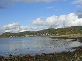
Rockcliffe is a small coastal tourist village in Dumfries and Galloway
in Scotland
, with a view of Rough Island
, Hestan Island
, the Solway Firth
and sometimes the Lake District
.
Rockcliffe lies on shore of the Rough Firth
and gives access to Rough Island by way of a tidal causeway. Road access is from Dalbeattie
and Dumfries
; although Kippford
is nearby there is no direct road route. Rockcliffe is linked to Sandyhills
, Barcloy Hill, Castle Point and Kippford by footpath.
There is little business in Rockcliffe other than the rental of holiday cottages, one tea room and one hotel. The village has a car park and a public toilet, but no other facilities to speak of.
The site of the 5th century dark age
hill fort
the Mote of Mark adjoins Rockcliffe.
Parts of Rockcliffe, in particular much of the land immediately to the north, are owned by the National Trust for Scotland
.
Dumfries and Galloway
Dumfries and Galloway is one of 32 unitary council areas of Scotland. It was one of the nine administrative 'regions' of mainland Scotland created in 1975 by the Local Government etc. Act 1973...
in Scotland
Scotland
Scotland is a country that is part of the United Kingdom. Occupying the northern third of the island of Great Britain, it shares a border with England to the south and is bounded by the North Sea to the east, the Atlantic Ocean to the north and west, and the North Channel and Irish Sea to the...
, with a view of Rough Island
Rough Island, Scotland
Rough Island is a tidal island in Rough Firth off the Solway Firth, Scotland. It is 24 m at its highest point.Since 1937 it has been in the ownership of the National Trust for Scotland...
, Hestan Island
Hestan Island
Hestan Island is a small coastal island in the Solway Firth, southwest Scotland.Hestan Island lies at the mouth of Auchencairn Bay in the region of Dumfries and Galloway in the former county of Kirkcudbrightshire...
, the Solway Firth
Solway Firth
The Solway Firth is a firth that forms part of the border between England and Scotland, between Cumbria and Dumfries and Galloway. It stretches from St Bees Head, just south of Whitehaven in Cumbria, to the Mull of Galloway, on the western end of Dumfries and Galloway. The Isle of Man is also very...
and sometimes the Lake District
Lake District
The Lake District, also commonly known as The Lakes or Lakeland, is a mountainous region in North West England. A popular holiday destination, it is famous not only for its lakes and its mountains but also for its associations with the early 19th century poetry and writings of William Wordsworth...
.
Rockcliffe lies on shore of the Rough Firth
Rough Firth
Rough Firth is an inlet on the northern coast of the Solway Firth in Dumfries and Galloway, Scotland.Rough Firth lies between Almorness Point and Castlehill Point. It contains Rough Island. The village of Kippford stands near the head of the firth where the Urr Water reaches the sea; the only other...
and gives access to Rough Island by way of a tidal causeway. Road access is from Dalbeattie
Dalbeattie
Dalbeattie is a town in Dumfries and Galloway , Scotland.Dalbeattie is situated in a wooded valley on the Urr Water east of Castle Douglas and south west of Dumfries...
and Dumfries
Dumfries
Dumfries is a market town and former royal burgh within the Dumfries and Galloway council area of Scotland. It is near the mouth of the River Nith into the Solway Firth. Dumfries was the county town of the former county of Dumfriesshire. Dumfries is nicknamed Queen of the South...
; although Kippford
Kippford
Kippford is a small village along the Solway coast, in Dumfries and Galloway, Scotland.-Geography:Kippford stretches along the banks of the Urr estuary and in places is only one house wide, being hemmed in between the forested Mark hill and the sea...
is nearby there is no direct road route. Rockcliffe is linked to Sandyhills
Sandyhills
Sandyhills is a district in the Scottish city of Glasgow. It is situated north of the River Clyde.It is in close proximity to other districts of Glasgow namely Mount Vernon and Baillieston....
, Barcloy Hill, Castle Point and Kippford by footpath.
There is little business in Rockcliffe other than the rental of holiday cottages, one tea room and one hotel. The village has a car park and a public toilet, but no other facilities to speak of.
The site of the 5th century dark age
Early Middle Ages
The Early Middle Ages was the period of European history lasting from the 5th century to approximately 1000. The Early Middle Ages followed the decline of the Western Roman Empire and preceded the High Middle Ages...
hill fort
Hill fort
A hill fort is a type of earthworks used as a fortified refuge or defended settlement, located to exploit a rise in elevation for defensive advantage. They are typically European and of the Bronze and Iron Ages. Some were used in the post-Roman period...
the Mote of Mark adjoins Rockcliffe.
Parts of Rockcliffe, in particular much of the land immediately to the north, are owned by the National Trust for Scotland
National Trust for Scotland
The National Trust for Scotland for Places of Historic Interest or Natural Beauty, commonly known as the National Trust for Scotland describes itself as the conservation charity that protects and promotes Scotland's natural and cultural heritage for present and future generations to...
.