

River Hodder
Encyclopedia

Lancashire
Lancashire is a non-metropolitan county of historic origin in the North West of England. It takes its name from the city of Lancaster, and is sometimes known as the County of Lancaster. Although Lancaster is still considered to be the county town, Lancashire County Council is based in Preston...
, England
England
England is a country that is part of the United Kingdom. It shares land borders with Scotland to the north and Wales to the west; the Irish Sea is to the north west, the Celtic Sea to the south west, with the North Sea to the east and the English Channel to the south separating it from continental...
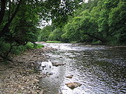
. The river is a County Biological Heritage Site.
It rises on White Hill and flows for approximately 23 miles to the River Ribble
River Ribble
The River Ribble is a river that runs through North Yorkshire and Lancashire, in northern England. The river's drainage basin also includes parts of Greater Manchester around Wigan.-Geography:...
, of which it is the largest tributary. The confluence of the rivers is an impressive sight, particularly when both are in spate.
The Hodder drains much of the Forest of Bowland
Forest of Bowland
The Forest of Bowland, also known as the Bowland Fells, is an area of barren gritstone fells, deep valleys and peat moorland, mostly in north-east Lancashire, England. A small part lies in North Yorkshire, and much of the area was historically part of the West Riding of Yorkshire...
Area of Outstanding Natural Beauty
Area of Outstanding Natural Beauty
An Area of Outstanding Natural Beauty is an area of countryside considered to have significant landscape value in England, Wales or Northern Ireland, that has been specially designated by the Countryside Agency on behalf of the United Kingdom government; the Countryside Council for Wales on...
and all but the last mile of its course is through this scenic area.
The upper reaches of the river feed the large Stocks Reservoir
Stocks Reservoir
Stocks Reservoir is a reservoir situated at the head of the Hodder valley in the Forest of Bowland, Lancashire, England. The reservoir has a fly fishing club which is very popular in the summer months and a small cafe which is popular with walkers...
, which provides much of Lancashire's water supply. After exiting the reservoir, the Hodder continues in a general southward direction. It collects many tributaries from the valleys of Bowland and, lower down, parts of the Ribble Valley
Ribble Valley
Ribble Valley is a local government district with borough status within the non-metropolitan county of Lancashire, England. Its council is based in Clitheroe. Other places include Whalley, Longridge and Ribchester. The area is so called due to the River Ribble which flows in its final stages...
. Most notable among the feeders of the Hodder are Croasdale Brook, Easington Brook, the River Dunsop
River Dunsop
The River Dunsop is a river in the Forest of Bowland in Northern England. It flows into the River Hodder at Dunsop Bridge.It begins at the confluence of the Brennand River and Whitendale River, both of which rise high up in the surrounding moorland. It then flows through the steep-sided Dunsop...
, Langden Brook and the River Loud
River Loud
The River Loud is a river of Lancashire, England.Starting out on Parlick, the Loud meanders mainly through the parish of Chipping, tracing its course first southwest, then southeast and, at Gill Bridge by Withinreap Farm, east before veering northeast, on a similar alignment to Longridge Road,...
.
Much of the land in the Hodder Valley further to the north is owned by the Crown as Duke of Lancaster
Duchy of Lancaster
The Duchy of Lancaster is one of the two royal duchies in England, the other being the Duchy of Cornwall. It is held in trust for the Sovereign, and is used to provide income for the use of the British monarch...
, whilst further down, farming land on the Stonyhurst Estate
Stonyhurst
Stonyhurst is the name of a rural estate owned by the Society of Jesus near Clitheroe in Lancashire, England. It is dominated by Stonyhurst College, its preparatory school Stonyhurst Saint Mary's Hall and the parish Church of St Peter's.-The Estate:...
is owned by Stonyhurst College
Stonyhurst College
Stonyhurst College is a Roman Catholic independent school, adhering to the Jesuit tradition. It is located on the Stonyhurst Estate near the village of Hurst Green in the Ribble Valley area of Lancashire, England, and occupies a Grade I listed building...
and the Jesuits. The river runs close to the College and passes adjacent to the former preparatory school, Hodder Place
Stonyhurst Saint Mary's Hall
Stonyhurst St Mary's Hall is the preparatory school to Stonyhurst College. It is an independent co-educational Catholic school founded by the Society of Jesus . It is primarily a day school but has some boarders...
. The river lends its name to the pre-preparatory department at Stonyhurst, "Hodder House" and also years three to five known collectively as "Hodder Playroom".
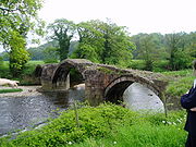
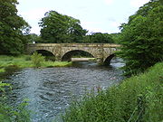
The River Hodder eventually joins the River Ribble
River Ribble
The River Ribble is a river that runs through North Yorkshire and Lancashire, in northern England. The river's drainage basin also includes parts of Greater Manchester around Wigan.-Geography:...
near Great Mitton
Great Mitton
Great Mitton is a village and a civil parish in the Ribble Valley, Lancashire, England. It is separated from the civil parish of Little Mitton by the River Ribble, both lie about 3 miles from the town of Clitheroe...
, close to the River Calder
River Calder, Lancashire
The River Calder is a major tributary of the River Ribble, starting in Cliviger close to Burnley in Lancashire, England and is around 24 km / 15 miles in length. Its source is very close to that of the West Yorkshire river with the same name, and that of the River Irwell. It flows through...
.
The relief of the river starts over 400 m above sea level and within a distance of 15 km it drops to 99 m above sea level.
The Lower Hodder marks the historical county boundary between Lancashire and the West Riding of Yorkshire
West Riding of Yorkshire
The West Riding of Yorkshire is one of the three historic subdivisions of Yorkshire, England. From 1889 to 1974 the administrative county, County of York, West Riding , was based closely on the historic boundaries...
. It formed an important early feature in the development of the ancient Lordship of Bowland
Lordship of Bowland
The Lordship of Bowland, an ancient English title connected with the Forest of Bowland in the northwest of England, was once thought lost and was only recently rediscovered. It disappeared from sight in 1885 when the estates of the Towneleys, one of Lancashire’s great aristocratic families, were...
.
Etymology
The name Hodder is likely derived from Brythonic. Its meaning is either "pleasant stream" or possibly "boundary" (WelshWelsh language
Welsh is a member of the Brythonic branch of the Celtic languages spoken natively in Wales, by some along the Welsh border in England, and in Y Wladfa...
yr odre), the latter suggesting that the Lancashire/Yorkshire border has its origins in the depths of antiquity. It is thought that Bowland
Forest of Bowland
The Forest of Bowland, also known as the Bowland Fells, is an area of barren gritstone fells, deep valleys and peat moorland, mostly in north-east Lancashire, England. A small part lies in North Yorkshire, and much of the area was historically part of the West Riding of Yorkshire...
takes its name from the Old Norse boga- meaning a bow in a river; the Hodder being characterised by the way it meanders and twists through the Bowland landscape.
Diversion
In geological history, the Hodder did not flow eastward around Longridge FellLongridge Fell
Longridge Fell is a fell near the English town of Longridge, Lancashire. It lies within the Forest of Bowland Area of Outstanding Natural Beauty. As its name suggests, it takes the form of a long ridge which rises in a northeasterly direction from the town of Longridge to its summit 4.5 miles distant...
to join the River Ribble
River Ribble
The River Ribble is a river that runs through North Yorkshire and Lancashire, in northern England. The river's drainage basin also includes parts of Greater Manchester around Wigan.-Geography:...
, but instead ran westward along the Loud
River Loud
The River Loud is a river of Lancashire, England.Starting out on Parlick, the Loud meanders mainly through the parish of Chipping, tracing its course first southwest, then southeast and, at Gill Bridge by Withinreap Farm, east before veering northeast, on a similar alignment to Longridge Road,...
valley from Doeford Bridge to the Derby Arms north of Longridge
Longridge
Longridge is a small town and civil parish in the borough of Ribble Valley in Lancashire, England. It is situated north-east of the city of Preston, at the western end of Longridge Fell, a long ridge above the River Ribble. Its nearest neighbours are Grimsargh and the Roman town of Ribchester , ...
(reversing its modern-day eastward flow), continuing south-westward through Halfpenny Lane on the west side of Longridge to join either Blundell Brook past Broughton
Broughton, Lancashire
Broughton is a village and civil parish in the City of Preston, Lancashire, England, about north of Preston city centre. According to the 2001 census it had a population of 1,735...
church and Woodplumpton
Woodplumpton
Woodplumpton is a village and civil parish in the City of Preston, Lancashire, England, located north of Preston.-Geography:It is part of the Fylde, a flat area of land between the Forest of Bowland and the Lancashire coast.-Community:...
to join the River Wyre
River Wyre
The River Wyre is a river in Lancashire, United Kingdom, which flows into the Irish Sea at Fleetwood. It is approximately 28 miles in length...
, or else Savick Brook
Ribble Link
The Millennium Ribble Link is a Linear Water Park and new navigation which links the once-isolated Lancaster Canal in Lancashire, England to the River Ribble...
through Fulwood
Fulwood, Lancashire
Fulwood is an unparished area of the City of Preston, Lancashire, England, about north of the city centre. It had a population of 33,171 in 2001.- Economy and society :Fulwood remains a distinctive division of Preston...
to join the River Ribble
River Ribble
The River Ribble is a river that runs through North Yorkshire and Lancashire, in northern England. The river's drainage basin also includes parts of Greater Manchester around Wigan.-Geography:...
.
Settlements
The Hodder does not pass by any major towns, but the following villages are situated along the river:- SlaidburnSlaidburnSlaidburn is a village and civil parish within the Ribble Valley district of Lancashire, England. With a population in 2001 of just under 300, it covers just over 5000 acres of the Forest of Bowland...
- Newton
- Dunsop BridgeDunsop BridgeDunsop Bridge is a village within the Ribble Valley borough of Lancashire, England, situated north-west of Clitheroe, south-east of Lancaster and east of Skipton. It is in the civil parish of Bowland Forest High....
- WhitewellWhitewellWhitewell is a hamlet within the Ribble Valley borough of Lancashire, England, in the Forest of Bowland Area of Outstanding Natural Beauty. Historically, it lay on the border of the former West Riding of Yorkshire. It stands above a picturesque bend in the River Hodder.The hamlet comprises Upper...
- Great MittonGreat MittonGreat Mitton is a village and a civil parish in the Ribble Valley, Lancashire, England. It is separated from the civil parish of Little Mitton by the River Ribble, both lie about 3 miles from the town of Clitheroe...