

River Calder, West Yorkshire
Encyclopedia
The River Calder is a river
in West Yorkshire
, in Northern England
.
The Calder rises on the green eastern slopes of the Pennines
flows through alternating green countryside, former woollen-mill villages, and large and small towns before joining the River Aire
near Castleford.
The river's valley is known as Calderdale
, which gives its name to the large urban and rural borough
(centred on Halifax
) through which the upper river flows. The lower reaches flow through the boroughs of Kirklees
(based on Huddersfield) and Wakefield
. However, the river does not flow through the centres of Halifax and Huddersfield, which are on the Calder's main tributaries, the River Hebble
and River Colne
respectively. The only large town centres through which the Calder flows are Brighouse
, Mirfield
, Dewsbury
and the city of Wakefield
.
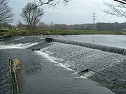
The river itself is only navigable in short sections, but these sections are connected by artificial "cuts" (eg Horbury Cut) to form the Calder and Hebble Navigation
, a popular leisure waterway which is part of the connected inland waterway network of England and Wales.
, and drains an area of 957 km². It flows for a distance of around 72 kilometres (44.7 mi) through Cornholme
, Todmorden
, Eastwood
, Hebden Bridge
, Mytholmroyd
, Luddendenfoot
, Sowerby Bridge
, Copley
, Elland
, Brighouse
, Mirfield
, Dewsbury
, Horbury Bridge
and on to Wakefield.
The catchment lies on carboniferous
rocks of Millstone Grit
, and is heavily reservoired, with 39 reservoirs licensed to provide water. The river is joined by Hebden Water at Hebden Bridge, and is linked to the town of Rochdale
, Greater Manchester
across the Pennines
via the Rochdale Canal
.
Across much of its length, the Calder is canalised and becomes the Calder and Hebble Navigation
. It is also part of the Aire and Calder Navigation
, and to the east of Castleford
, it merges into the River Aire
, going on to join the Humber Estuary and the North Sea
.
 The river was key to the success of the textile industries in the local area, and flows through the area known as the Yorkshire Heavy Woollen District
. Many major mills were constructed along its banks, particularly at Dewsbury
and Wakefield
, but also in the smaller communities of Hebden Bridge
, Sowerby Bridge
and Todmorden
, as well as along its tributaries: the Hebble at Halifax
, and the Colne at Huddersfield
. The mills in the Upper Calder Valley
specialised in cotton weaving, with some cotton spinning , while those in the lower part of the valley specialised in wool and shoddy. Some of these structures still exist as listed buildings, although the large scale production of yarn
and textile
has now ceased.
The river formed an important transportation system for raw materials and the products of the mills, particularly prior to the development of other infrastructures such as road
and railway links to the area. At many places, the river is not navigable because of weirs or the shallow depth, and passage for boats was made by the creation of cuts where boats are able to enter the Calder and Hebble Navigation
. Work began to make the Calder navigable above Wakefield in 1758.
Wakefield's medieval nine arched bridge is 320 feet long, was built in sandstone
between 1342 and 1356, and replaced an earlier wooden structure on the site of an ancient ford. The chantry chapel
on the bridge was licensed in 1356. At Wakefield, a variety of former mill
buildings are currently being redeveloped to create a Waterfront project which will combine residential housing, offices, galleries and public spaces. The Hepworth Wakefield
opened in 2011.
but pollution from the textile and chemical industries along its banks led to the death of the salmon population by the mid 19th century. The last salmon on record was caught at Wakefield in 1850, however there is evidence that they are returning, with sightings on the lower river at Castleford in 2008 and alleged catchings much further upstream. Around Huddersfield
, Mirfield
and Wakefield
are popular areas for coarse fishing, roach, perch
, chub
, dace
, minnow
s, gudgeon
, pike
, bream and trout
. However the areas upstream of Dewsbury are quickly becoming cleaner and more suited to game and specialised river cyprinids like Barbel as well as general coarse fish that are also doing very well.
Alongside the river are four Sites of Special Scientific Interest.
Recent improvements in reducing the amount of pollution have led to the return of native wildlife, such as the otter
and kingfisher
to stretches of the river.
Kingfishers are easily spotted (all year round, due to its orange underbelly) all the way up and down the river's course and are quite numerous around the mirfield area.
Close to its source at Heald Foot, the water is polluted by the remains of past opencast mining
activities and a landfill site. This has also led to a significant amount of soil erosion, with major mudslides into the river and its tributaries in 1947, 1982, 1991 and 2001.
As the river reached Huddersfield, the traditional textile
industries created considerable amount of water pollution, particularly through the processes involved in the production of chemical dye
and in scouring the wool clean. The enormous growth of the population over the last hundred years (currently over 800,000 people live within the river's catchment) has caused other problems in relation to sewage
. Another major source of pollution until recently came from a disused tar distillery in Mirfield
http://www.ehj-online.com/archive/2000/january2005/january2.html.
In the middle 1950s the river was so polluted by dyeworks in the middle reaches between Todmorden and Sowerby Bridge, that it ran different opaque colours from day to day. On Easter Monday, after a long weekend holiday shutdown, the water cleared and the river bottom could actually be seen, looking like a grey wool blanket. Tighter controls during the 1950s led to an improvement in water quality, and presently organisations such as Calder Future are working collaboratively with local industries and Yorkshire Water
to promote more responsible use of the river and to re-establish lost wildlife along its banks.
A variety of flood defences are in operation along the Calder Valley to prevent the recurrence of floods which devastated communities in the early part of this century. At Wakefield, for example, the lake at Pugneys Country Park
is used as an overflow for the river in order to protect the town.
The recently regenerated Wakefield Waterfront area is defended by one of the most sophisticated flood defence systems in Europe. This complex of computer controlled automatic flood barriers are housed below ground and rise automatically when a flood threat is detected.
River
A river is a natural watercourse, usually freshwater, flowing towards an ocean, a lake, a sea, or another river. In a few cases, a river simply flows into the ground or dries up completely before reaching another body of water. Small rivers may also be called by several other names, including...
in West Yorkshire
West Yorkshire
West Yorkshire is a metropolitan county within the Yorkshire and the Humber region of England with a population of 2.2 million. West Yorkshire came into existence as a metropolitan county in 1974 after the passage of the Local Government Act 1972....
, in Northern England
Northern England
Northern England, also known as the North of England, the North or the North Country, is a cultural region of England. It is not an official government region, but rather an informal amalgamation of counties. The southern extent of the region is roughly the River Trent, while the North is bordered...
.
The Calder rises on the green eastern slopes of the Pennines
Pennines
The Pennines are a low-rising mountain range, separating the North West of England from Yorkshire and the North East.Often described as the "backbone of England", they form a more-or-less continuous range stretching from the Peak District in Derbyshire, around the northern and eastern edges of...
flows through alternating green countryside, former woollen-mill villages, and large and small towns before joining the River Aire
River Aire
The River Aire is a major river in Yorkshire, England of length . Part of the river is canalised, and is known as the Aire and Calder Navigation....
near Castleford.
The river's valley is known as Calderdale
Calderdale
The Metropolitan Borough of Calderdale is a metropolitan borough of West Yorkshire, England, through which the upper part of the River Calder flows, and from which it takes its name...
, which gives its name to the large urban and rural borough
Calderdale
The Metropolitan Borough of Calderdale is a metropolitan borough of West Yorkshire, England, through which the upper part of the River Calder flows, and from which it takes its name...
(centred on Halifax
Halifax, West Yorkshire
Halifax is a minster town, within the Metropolitan Borough of Calderdale in West Yorkshire, England. It has an urban area population of 82,056 in the 2001 Census. It is well-known as a centre of England's woollen manufacture from the 15th century onward, originally dealing through the Halifax Piece...
) through which the upper river flows. The lower reaches flow through the boroughs of Kirklees
Kirklees
The Metropolitan Borough of Kirklees is a metropolitan borough of West Yorkshire, England. It has a population of 401,000 and includes the settlements of Batley, Birstall, Cleckheaton, Denby Dale, Dewsbury, Heckmondwike, Holmfirth, Huddersfield, Kirkburton, Marsden, Meltham, Mirfield and Slaithwaite...
(based on Huddersfield) and Wakefield
Wakefield
Wakefield is the main settlement and administrative centre of the City of Wakefield, a metropolitan district of West Yorkshire, England. Located by the River Calder on the eastern edge of the Pennines, the urban area is and had a population of 76,886 in 2001....
. However, the river does not flow through the centres of Halifax and Huddersfield, which are on the Calder's main tributaries, the River Hebble
River Hebble
Hebble Brook is the body of water passing from Ogden Reservoir south, at Ogden, Halifax. The reservoir itself is sourced from water draining off Skirden Edge, through Skirden Clough, to the west and from the north the reservoir takes in water from Deep Gulf and Spa Flat, above the now disused Fly...
and River Colne
River Colne, West Yorkshire
The River Colne is a river in West Yorkshire formed by a confluence at the foot of the Pennines close to the village of Marsden.-Course:Numerous brooks formed by rainwater high in the Pennines of West Yorkshire, flow down the hillsides through the small valleys to feed two Yorkshire Water...
respectively. The only large town centres through which the Calder flows are Brighouse
Brighouse
Brighouse is a town within the Metropolitan Borough of Calderdale, in West Yorkshire, England. It is situated on the River Calder, east of Halifax in the Pennines. It is served by Junction 25 of the M62 motorway and Brighouse railway station on the Caldervale Line and Huddersfield Line. In the...
, Mirfield
Mirfield
Mirfield is a small town and civil parish within the Metropolitan Borough of Kirklees, in West Yorkshire, England. It is located on the A644 road between Brighouse and Dewsbury...
, Dewsbury
Dewsbury
Dewsbury is a minster town in the Metropolitan Borough of Kirklees, in West Yorkshire, England. It is to the west of Wakefield, east of Huddersfield and south of Leeds...
and the city of Wakefield
Wakefield
Wakefield is the main settlement and administrative centre of the City of Wakefield, a metropolitan district of West Yorkshire, England. Located by the River Calder on the eastern edge of the Pennines, the urban area is and had a population of 76,886 in 2001....
.
The river itself is only navigable in short sections, but these sections are connected by artificial "cuts" (eg Horbury Cut) to form the Calder and Hebble Navigation
Calder and Hebble Navigation
The Calder and Hebble Navigation is a Broad inland waterway in West Yorkshire, England, which has remained navigable since it was opened.-History:...
, a popular leisure waterway which is part of the connected inland waterway network of England and Wales.
Etymology
The name 'Calder' is thought to come from the early British meaning 'hard' or violent waters or stream, or possibly from the Celtic, meaning 'river of stones'. However, another likely explanation is that it is a corruption of "Gauls' der"; "Gauls" being an ancient name for the Celts and "der" being Celtic for water. Hence Calder means the Celts' River. This is likely because the moorlands and rugged valleys of upper Calderdale remained a Celtic area for at least two centuries after the surrounding lowlands became dominated by Anglo-Saxon culture. That history is also reflected in the name of a village, Walsden, just inside the border of upper Calderdale, which is derived from Wales Dene, or "Valley of the Welsh" in Anglo-Saxon.Geography
The river rises approximately 400 metres (1,312.3 ft) above sea level at Heald Moor, north-west of TodmordenTodmorden
Todmorden is a market town and civil parish, located 17 miles from Manchester, within the Metropolitan Borough of Calderdale, in West Yorkshire, England. It forms part of the Upper Calder Valley and has a total population of 14,941....
, and drains an area of 957 km². It flows for a distance of around 72 kilometres (44.7 mi) through Cornholme
Cornholme
Cornholme is a village within the Metropolitan Borough of Calderdale, in West Yorkshire, England. It lies at the edge of Calderdale, on the boundary with Lancashire, and in the narrow Calder Valley about northwest of Todmorden....
, Todmorden
Todmorden
Todmorden is a market town and civil parish, located 17 miles from Manchester, within the Metropolitan Borough of Calderdale, in West Yorkshire, England. It forms part of the Upper Calder Valley and has a total population of 14,941....
, Eastwood
Eastwood, West Yorkshire
Eastwood is a place within the civil parish of Todmorden and Metropolitan Borough of Calderdale, in West Yorkshire, England. It lies west from Halifax, roughly equidistant from Todmorden's town centre, which is to the southwest, and Hebden Bridge, which is 2 miles to the northeast, along the...
, Hebden Bridge
Hebden Bridge
Hebden Bridge is a market town within the Metropolitan Borough of Calderdale, in West Yorkshire, England. It forms part of the Upper Calder Valley and lies 8 miles west of Halifax and 14 miles north east of Rochdale, at the confluence of the River Calder and the River Hebden .A 2004 profile of...
, Mytholmroyd
Mytholmroyd
Mytholmroyd is a town within the Metropolitan Borough of Calderdale, in West Yorkshire, England. It lies east of Hebden Bridge and west of Halifax....
, Luddendenfoot
Luddendenfoot
Luddendenfoot or Luddenden Foot is a community in Calderdale, West Yorkshire, England. It lies along the Upper Calder Valley below the village of Luddenden, between Sowerby Bridge and Hebden Bridge.-Cultural reference and notable people:...
, Sowerby Bridge
Sowerby Bridge
Sowerby Bridge is a market town that lies within the Upper Calder Valley in the district of Calderdale in the county of West Yorkshire, in northern England.-Geography:Sowerby Bridge is situated on the edge of Halifax, about three miles from its centre...
, Copley
Copley, West Yorkshire
Copley is a village in the metropolitan borough of Calderdale, in the county of West Yorkshire, England, south of Halifax and east of Sowerby Bridge, by the River Calder and the Calder and Hebble Navigation. It is known locally for the odour from the sewage works.-History:It is the site of a...
, Elland
Elland
Elland is a market town in Calderdale, in the county of West Yorkshire, England, south of Halifax, by the River Calder and the Calder and Hebble Navigation. The area of Elland was called Elant in the Domesday Book...
, Brighouse
Brighouse
Brighouse is a town within the Metropolitan Borough of Calderdale, in West Yorkshire, England. It is situated on the River Calder, east of Halifax in the Pennines. It is served by Junction 25 of the M62 motorway and Brighouse railway station on the Caldervale Line and Huddersfield Line. In the...
, Mirfield
Mirfield
Mirfield is a small town and civil parish within the Metropolitan Borough of Kirklees, in West Yorkshire, England. It is located on the A644 road between Brighouse and Dewsbury...
, Dewsbury
Dewsbury
Dewsbury is a minster town in the Metropolitan Borough of Kirklees, in West Yorkshire, England. It is to the west of Wakefield, east of Huddersfield and south of Leeds...
, Horbury Bridge
Horbury
-Demography:In 2008 Horbury had a largely white population compared with Yorkshire and the Humber.-Population change:The population of Horbury in 2001 was 10,002-Transport:...
and on to Wakefield.
The catchment lies on carboniferous
Carboniferous
The Carboniferous is a geologic period and system that extends from the end of the Devonian Period, about 359.2 ± 2.5 Mya , to the beginning of the Permian Period, about 299.0 ± 0.8 Mya . The name is derived from the Latin word for coal, carbo. Carboniferous means "coal-bearing"...
rocks of Millstone Grit
Millstone Grit
Millstone Grit is the name given to any of a number of coarse-grained sandstones of Carboniferous age which occur in the Northern England. The name derives from its use in earlier times as a source of millstones for use principally in watermills...
, and is heavily reservoired, with 39 reservoirs licensed to provide water. The river is joined by Hebden Water at Hebden Bridge, and is linked to the town of Rochdale
Rochdale
Rochdale is a large market town in Greater Manchester, England. It lies amongst the foothills of the Pennines on the River Roch, north-northwest of Oldham, and north-northeast of the city of Manchester. Rochdale is surrounded by several smaller settlements which together form the Metropolitan...
, Greater Manchester
Greater Manchester
Greater Manchester is a metropolitan county in North West England, with a population of 2.6 million. It encompasses one of the largest metropolitan areas in the United Kingdom and comprises ten metropolitan boroughs: Bolton, Bury, Oldham, Rochdale, Stockport, Tameside, Trafford, Wigan, and the...
across the Pennines
Pennines
The Pennines are a low-rising mountain range, separating the North West of England from Yorkshire and the North East.Often described as the "backbone of England", they form a more-or-less continuous range stretching from the Peak District in Derbyshire, around the northern and eastern edges of...
via the Rochdale Canal
Rochdale Canal
The Rochdale Canal is a navigable "broad" canal in northern England, part of the connected system of the canals of Great Britain. The "Rochdale" in its name refers to the town of Rochdale, Greater Manchester, through which the canal passes....
.
Across much of its length, the Calder is canalised and becomes the Calder and Hebble Navigation
Calder and Hebble Navigation
The Calder and Hebble Navigation is a Broad inland waterway in West Yorkshire, England, which has remained navigable since it was opened.-History:...
. It is also part of the Aire and Calder Navigation
Aire and Calder Navigation
The Aire and Calder Navigation is a river and canal system of the River Aire and the River Calder in the metropolitan county of West Yorkshire, England. The first improvements to the rivers above Knottingley were completed in 1704 when the Aire was made navigable to Leeds and the Calder to...
, and to the east of Castleford
Castleford
Castleford is the largest of the "five towns" district in the metropolitan borough of the City of Wakefield, in West Yorkshire, England. It is near Pontefract, and has a population of 37,525 according to the 2001 Census, but has seen a rise in recent years and is now around 45-50,000. To the north...
, it merges into the River Aire
River Aire
The River Aire is a major river in Yorkshire, England of length . Part of the river is canalised, and is known as the Aire and Calder Navigation....
, going on to join the Humber Estuary and the North Sea
North Sea
In the southwest, beyond the Straits of Dover, the North Sea becomes the English Channel connecting to the Atlantic Ocean. In the east, it connects to the Baltic Sea via the Skagerrak and Kattegat, narrow straits that separate Denmark from Norway and Sweden respectively...
.
History
Heavy Woollen District
The Heavy Woollen District is named because of the heavyweight cloth manufactured in an area of West Yorkshire, England. Dewsbury, Batley, Heckmondwike and Ossett are the core of the area. Liversedge, Gomersal, Gildersome, Birkenshaw, Mirfield, Cleckheaton, Morley, Tingley, East Ardsley, Birstall...
. Many major mills were constructed along its banks, particularly at Dewsbury
Dewsbury
Dewsbury is a minster town in the Metropolitan Borough of Kirklees, in West Yorkshire, England. It is to the west of Wakefield, east of Huddersfield and south of Leeds...
and Wakefield
Wakefield
Wakefield is the main settlement and administrative centre of the City of Wakefield, a metropolitan district of West Yorkshire, England. Located by the River Calder on the eastern edge of the Pennines, the urban area is and had a population of 76,886 in 2001....
, but also in the smaller communities of Hebden Bridge
Hebden Bridge
Hebden Bridge is a market town within the Metropolitan Borough of Calderdale, in West Yorkshire, England. It forms part of the Upper Calder Valley and lies 8 miles west of Halifax and 14 miles north east of Rochdale, at the confluence of the River Calder and the River Hebden .A 2004 profile of...
, Sowerby Bridge
Sowerby Bridge
Sowerby Bridge is a market town that lies within the Upper Calder Valley in the district of Calderdale in the county of West Yorkshire, in northern England.-Geography:Sowerby Bridge is situated on the edge of Halifax, about three miles from its centre...
and Todmorden
Todmorden
Todmorden is a market town and civil parish, located 17 miles from Manchester, within the Metropolitan Borough of Calderdale, in West Yorkshire, England. It forms part of the Upper Calder Valley and has a total population of 14,941....
, as well as along its tributaries: the Hebble at Halifax
Halifax, West Yorkshire
Halifax is a minster town, within the Metropolitan Borough of Calderdale in West Yorkshire, England. It has an urban area population of 82,056 in the 2001 Census. It is well-known as a centre of England's woollen manufacture from the 15th century onward, originally dealing through the Halifax Piece...
, and the Colne at Huddersfield
Huddersfield
Huddersfield is a large market town within the Metropolitan Borough of Kirklees, in West Yorkshire, England, situated halfway between Leeds and Manchester. It lies north of London, and south of Bradford, the nearest city....
. The mills in the Upper Calder Valley
Upper Calder Valley
The Upper Calder Valley lies in West Yorkshire in northern England, and covers the towns of Todmorden, Hebden Bridge, Mytholmroyd, Luddendenfoot, and Sowerby Bridge, as well as a number of smaller settlements such as Portsmouth, Cornholme, Walsden and Eastwood. The valley is named after the River...
specialised in cotton weaving, with some cotton spinning , while those in the lower part of the valley specialised in wool and shoddy. Some of these structures still exist as listed buildings, although the large scale production of yarn
Yarn
Yarn is a long continuous length of interlocked fibres, suitable for use in the production of textiles, sewing, crocheting, knitting, weaving, embroidery and ropemaking. Thread is a type of yarn intended for sewing by hand or machine. Modern manufactured sewing threads may be finished with wax or...
and textile
Textile
A textile or cloth is a flexible woven material consisting of a network of natural or artificial fibres often referred to as thread or yarn. Yarn is produced by spinning raw fibres of wool, flax, cotton, or other material to produce long strands...
has now ceased.
The river formed an important transportation system for raw materials and the products of the mills, particularly prior to the development of other infrastructures such as road
Road
A road is a thoroughfare, route, or way on land between two places, which typically has been paved or otherwise improved to allow travel by some conveyance, including a horse, cart, or motor vehicle. Roads consist of one, or sometimes two, roadways each with one or more lanes and also any...
and railway links to the area. At many places, the river is not navigable because of weirs or the shallow depth, and passage for boats was made by the creation of cuts where boats are able to enter the Calder and Hebble Navigation
Calder and Hebble Navigation
The Calder and Hebble Navigation is a Broad inland waterway in West Yorkshire, England, which has remained navigable since it was opened.-History:...
. Work began to make the Calder navigable above Wakefield in 1758.
Wakefield's medieval nine arched bridge is 320 feet long, was built in sandstone
Sandstone
Sandstone is a sedimentary rock composed mainly of sand-sized minerals or rock grains.Most sandstone is composed of quartz and/or feldspar because these are the most common minerals in the Earth's crust. Like sand, sandstone may be any colour, but the most common colours are tan, brown, yellow,...
between 1342 and 1356, and replaced an earlier wooden structure on the site of an ancient ford. The chantry chapel
Chantry Chapel of St Mary the Virgin, Wakefield
The Chantry Chapel of St Mary the Virgin, Wakefield is a chantry chapel in Wakefield, West Yorkshire, England and is designated a Grade I Listed building by English Heritage. It is located south of the city centre on the medieval bridge over the River Calder. It is the only survivor of four...
on the bridge was licensed in 1356. At Wakefield, a variety of former mill
Watermill
A watermill is a structure that uses a water wheel or turbine to drive a mechanical process such as flour, lumber or textile production, or metal shaping .- History :...
buildings are currently being redeveloped to create a Waterfront project which will combine residential housing, offices, galleries and public spaces. The Hepworth Wakefield
The Hepworth Wakefield
The Hepworth Wakefield is an art gallery in Wakefield, West Yorkshire, England, which opened on 21 May 2011. The gallery, is situated on the south side of the River Calder and takes its name from artist and sculptor Barbara Hepworth who was born and educated in the city.The gallery was designed by...
opened in 2011.
Wildlife and fish
Until the 19th century, the Calder was home to large numbers of salmonAtlantic salmon
The Atlantic salmon is a species of fish in the family Salmonidae, which is found in the northern Atlantic Ocean and in rivers that flow into the north Atlantic and the north Pacific....
but pollution from the textile and chemical industries along its banks led to the death of the salmon population by the mid 19th century. The last salmon on record was caught at Wakefield in 1850, however there is evidence that they are returning, with sightings on the lower river at Castleford in 2008 and alleged catchings much further upstream. Around Huddersfield
Huddersfield
Huddersfield is a large market town within the Metropolitan Borough of Kirklees, in West Yorkshire, England, situated halfway between Leeds and Manchester. It lies north of London, and south of Bradford, the nearest city....
, Mirfield
Mirfield
Mirfield is a small town and civil parish within the Metropolitan Borough of Kirklees, in West Yorkshire, England. It is located on the A644 road between Brighouse and Dewsbury...
and Wakefield
Wakefield
Wakefield is the main settlement and administrative centre of the City of Wakefield, a metropolitan district of West Yorkshire, England. Located by the River Calder on the eastern edge of the Pennines, the urban area is and had a population of 76,886 in 2001....
are popular areas for coarse fishing, roach, perch
European perch
The European perch, Perca fluviatilis, is a predatory species of perch found in Europe and Asia. In some areas it is known as the redfin perch or English perch, and it is often known simply as perch. The species is a popular quarry for anglers and has been widely introduced beyond its native area,...
, chub
European chub
The European chub , sometimes called the round chub, fat chub, chevin, pollard or simply "the" chub, is a freshwater fish of the family Cyprinidae...
, dace
Common dace
The common dace , also known as the dace or the Eurasian dace, is a fresh- or brackish-water fish belonging to the family Cyprinidae. It is an inhabitant of the rivers and streams of Europe north of the Alps as well as in Asia. It is most abundant in France and Germany, and has also spread to...
, minnow
Minnow
Minnow is a general term used to refer to small freshwater and saltwater fish, especially those used as bait fish or for fishing bait. More specifically, it refers to small freshwater fish of the carp family.-True minnows:...
s, gudgeon
Gudgeon (fish)
Gudgeon is a common name for a number of small freshwater fishes of the families Cyprinidae, Eleotridae or Ptereleotridae. Most gudgeons are elongate, bottom-dwelling fish, many of which live in rapids and other fast moving water....
, pike
Northern Pike
The northern pike , is a species of carnivorous fish of the genus Esox...
, bream and trout
Brown trout
The brown trout and the sea trout are fish of the same species....
. However the areas upstream of Dewsbury are quickly becoming cleaner and more suited to game and specialised river cyprinids like Barbel as well as general coarse fish that are also doing very well.
Alongside the river are four Sites of Special Scientific Interest.
Recent improvements in reducing the amount of pollution have led to the return of native wildlife, such as the otter
Otter
The Otters are twelve species of semi-aquatic mammals which feed on fish and shellfish, and also other invertebrates, amphibians, birds and small mammals....
and kingfisher
Kingfisher
Kingfishers are a group of small to medium sized brightly coloured birds in the order Coraciiformes. They have a cosmopolitan distribution, with most species being found in the Old World and Australia...
to stretches of the river.
Kingfishers are easily spotted (all year round, due to its orange underbelly) all the way up and down the river's course and are quite numerous around the mirfield area.
Pollution
The river has been heavily polluted by the textile industry, and, more recently, chemical works along its banks.Close to its source at Heald Foot, the water is polluted by the remains of past opencast mining
Mining
Mining is the extraction of valuable minerals or other geological materials from the earth, from an ore body, vein or seam. The term also includes the removal of soil. Materials recovered by mining include base metals, precious metals, iron, uranium, coal, diamonds, limestone, oil shale, rock...
activities and a landfill site. This has also led to a significant amount of soil erosion, with major mudslides into the river and its tributaries in 1947, 1982, 1991 and 2001.
As the river reached Huddersfield, the traditional textile
Textile
A textile or cloth is a flexible woven material consisting of a network of natural or artificial fibres often referred to as thread or yarn. Yarn is produced by spinning raw fibres of wool, flax, cotton, or other material to produce long strands...
industries created considerable amount of water pollution, particularly through the processes involved in the production of chemical dye
Dye
A dye is a colored substance that has an affinity to the substrate to which it is being applied. The dye is generally applied in an aqueous solution, and requires a mordant to improve the fastness of the dye on the fiber....
and in scouring the wool clean. The enormous growth of the population over the last hundred years (currently over 800,000 people live within the river's catchment) has caused other problems in relation to sewage
Sewage
Sewage is water-carried waste, in solution or suspension, that is intended to be removed from a community. Also known as wastewater, it is more than 99% water and is characterized by volume or rate of flow, physical condition, chemical constituents and the bacteriological organisms that it contains...
. Another major source of pollution until recently came from a disused tar distillery in Mirfield
Mirfield
Mirfield is a small town and civil parish within the Metropolitan Borough of Kirklees, in West Yorkshire, England. It is located on the A644 road between Brighouse and Dewsbury...
http://www.ehj-online.com/archive/2000/january2005/january2.html.
In the middle 1950s the river was so polluted by dyeworks in the middle reaches between Todmorden and Sowerby Bridge, that it ran different opaque colours from day to day. On Easter Monday, after a long weekend holiday shutdown, the water cleared and the river bottom could actually be seen, looking like a grey wool blanket. Tighter controls during the 1950s led to an improvement in water quality, and presently organisations such as Calder Future are working collaboratively with local industries and Yorkshire Water
Yorkshire Water
Yorkshire Water is a water supply and treatment utility company servicing West Yorkshire, South Yorkshire, the East Riding of Yorkshire, part of North Lincolnshire, most of North Yorkshire and part of Derbyshire, in England. The company has its origins in the Yorkshire Water Authority, one of ten...
to promote more responsible use of the river and to re-establish lost wildlife along its banks.
Flooding and flood defences
The river has a history of flooding, mainly due to the high sides of its banks in its earlier stages, which cause rapid runoff of water following heavy rain. Much of the lower part of the river has been urbanised, therefore trapping flowing water within the engineered river channels. Fast flows of water cause the deposition of sediment collected from the river banks, raising the river height further.A variety of flood defences are in operation along the Calder Valley to prevent the recurrence of floods which devastated communities in the early part of this century. At Wakefield, for example, the lake at Pugneys Country Park
Pugneys Country Park
Pugneys Country Park is a park located on the A636 between Wakefield, West Yorkshire, England and Junction 39 of the M1 motorway.The area was developed from a former opencast mine and a sand and gravel quarry and was opened to the public in 1985...
is used as an overflow for the river in order to protect the town.
The recently regenerated Wakefield Waterfront area is defended by one of the most sophisticated flood defence systems in Europe. This complex of computer controlled automatic flood barriers are housed below ground and rise automatically when a flood threat is detected.
Leisure use of the river
The river is home to a variety of watersports activities:- a canoeingCanoeingCanoeing is an outdoor activity that involves a special kind of canoe.Open canoes may be 'poled' , sailed, 'lined and tracked' or even 'gunnel-bobbed'....
centre at Sowerby Bridge - waterskiing in gravel pits at Cromwell Bottom
- watersports and anglingAnglingAngling is a method of fishing by means of an "angle" . The hook is usually attached to a fishing line and the line is often attached to a fishing rod. Fishing rods are usually fitted with a fishing reel that functions as a mechanism for storing, retrieving and paying out the line. The hook itself...
at Pugneys Country Park - the use of leisure craft and narrowboats along the lower stretch of the river where navigation is made easier through the canals built during the Industrial RevolutionIndustrial RevolutionThe Industrial Revolution was a period from the 18th to the 19th century where major changes in agriculture, manufacturing, mining, transportation, and technology had a profound effect on the social, economic and cultural conditions of the times...
- Walking routes along the Pennine WayPennine WayThe Pennine Way is a National Trail in England. The trail runs from Edale, in the northern Derbyshire Peak District, north through the Yorkshire Dales and the Northumberland National Park and ends at Kirk Yetholm, just inside the Scottish border. The path runs along the Pennine hills, sometimes...
and Calderdale WayCalderdale WayThe Calderdale Way is a long-distance footpath of about fifty miles in West Yorkshire. It was devised in the 1970s to draw attention to some of the attractions in the district of Calderdale, which was being established at that time.... - Angling in areas is distributed between the following; Bradford No.1 angling association, Mirfield AC, Thornhill AC, and Wakefield AC. Some stretches are free and only require a valid Environment agency rod licence
Sources
- Kirklees site about the River Calder
- Rivers Info with images accessed 14 December 2007.