
Rivadavia Partido
Encyclopedia
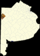
Rivadavia is a partido
in the northwest of Buenos Aires Province
, Argentina
, on the border with La Pampa Province
. It has an area of 3,940 square kilometres, and a population of 15,452 .
.jpg) The partido, created in 1910, has the town of América
The partido, created in 1910, has the town of América
as its capital, and its main economic activities are cattle
, and the cultivation of wheat
, maize
and soya beans. Most of the Soya grown in rivadavia partido is of the genetically modified variety.
.jpg) The Partido is named in honour of Bernardino Rivadavia
The Partido is named in honour of Bernardino Rivadavia
(1780–1845), veteran of the Argentine War of Independence
and President of Argentina
1826–1827.
Departments of Argentina
Departments form the second level of administrative division in the provinces of Argentina. There are no departments in the city of Buenos Aires, which has so far been divided into neighbourhoods as its administrative divisions, but is to be divided now into communes by a recently passed local act...
in the northwest of Buenos Aires Province
Buenos Aires Province
The Province of Buenos Aires is the largest and most populous province of Argentina. It takes the name from the city of Buenos Aires, which used to be the provincial capital until it was federalized in 1880...
, Argentina
Argentina
Argentina , officially the Argentine Republic , is the second largest country in South America by land area, after Brazil. It is constituted as a federation of 23 provinces and an autonomous city, Buenos Aires...
, on the border with La Pampa Province
La Pampa Province
La Pampa is a sparsely populated province of Argentina, located in the Pampas in the center of the country. Neighboring provinces are from the north clockwise San Luis, Córdoba, Buenos Aires, Río Negro, Neuquén and Mendoza.-History:...
. It has an area of 3,940 square kilometres, and a population of 15,452 .
América, Buenos Aires
América is a city in the province of Buenos Aires, Argentina, and the head town of the Rivadavia Partido, located some from Buenos Aires City and from the provincial capital, La Plata.Its population was, as per the 2001 census, 12,361.-External links:...
as its capital, and its main economic activities are cattle
Cattle
Cattle are the most common type of large domesticated ungulates. They are a prominent modern member of the subfamily Bovinae, are the most widespread species of the genus Bos, and are most commonly classified collectively as Bos primigenius...
, and the cultivation of wheat
Wheat
Wheat is a cereal grain, originally from the Levant region of the Near East, but now cultivated worldwide. In 2007 world production of wheat was 607 million tons, making it the third most-produced cereal after maize and rice...
, maize
Maize
Maize known in many English-speaking countries as corn or mielie/mealie, is a grain domesticated by indigenous peoples in Mesoamerica in prehistoric times. The leafy stalk produces ears which contain seeds called kernels. Though technically a grain, maize kernels are used in cooking as a vegetable...
and soya beans. Most of the Soya grown in rivadavia partido is of the genetically modified variety.
Name
Bernardino Rivadavia
Bernardino de la Trinidad Gónzalez Rivadavia y Rivadavia was the first president of Argentina, from February 8, 1826 to July 7, 1827 . He was a politician of the United Provinces of Río de la Plata, Argentina today...
(1780–1845), veteran of the Argentine War of Independence
Argentine War of Independence
The Argentine War of Independence was fought from 1810 to 1818 by Argentine patriotic forces under Manuel Belgrano, Juan José Castelli and José de San Martín against royalist forces loyal to the Spanish crown...
and President of Argentina
President of Argentina
The President of the Argentine Nation , usually known as the President of Argentina, is the head of state of Argentina. Under the national Constitution, the President is also the chief executive of the federal government and Commander-in-Chief of the armed forces.Through Argentine history, the...
1826–1827.
Districts (localidades)
- AméricaAmérica, Buenos AiresAmérica is a city in the province of Buenos Aires, Argentina, and the head town of the Rivadavia Partido, located some from Buenos Aires City and from the provincial capital, La Plata.Its population was, as per the 2001 census, 12,361.-External links:...
(capital, or cabecera, population 10,361, 35°29′18"S 62°58′31"W) - Badano
- Cerrito
- Condarco
- Fortín Olavarría (population 1.005, 35°42′05"S 63°01′25"W)
- González Moreno (population 1,663, 35°33′16"S 63°22′43"W)
- Mira Pampa (population 54, 35°52′06"S 63°22′20"W)
- Roosevelt (population 288, 35°50′53"S 63°17′32"W)
- San Mauricio (population 28, 35°30′45"S 63°11′10"W)
- Sansinena (population 468, 35°45′52"S 63°08′22"W)
- Sumblad (population 96)
- Vadano
- Valentín Gómez (35°39′03"S 63°15′16"W)
- Villa Sena
External links
- América Digital - portal (Spanish)