
Riley County, Kansas
Encyclopedia
Riley County is a county located in the U.S. state
of Kansas
. The county's population was 71,115 for the 2010 census. The largest city and county seat
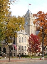
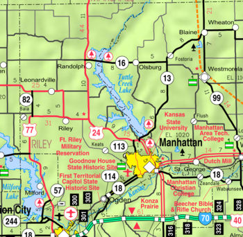
is Manhattan
. The county is part of the Manhattan, Kansas, Metropolitan Statistical Area.
Riley County is home to two of Kansas' largest employers: Fort Riley and Kansas State University
. Among notable current and former residents of Riley County are former Governor
John W. Carlin
, General Glen Edgerton and millionaire miner Horace A. W. Tabor.
, was on the western edge of the 33 original counties established by the Kansas Territorial Legislature in August 1855. For organizational purposes, Riley County initially had attached to it Geary County and all land west of Riley County, stretching most of the way across Kansas Territory
into present-day Colorado
.
The first Territorial Capital of Kansas Territory was located in the boundaries of Riley County, in the former town of Pawnee
, Kansas
. The site now falls within the boundaries of Fort Riley
, a U.S. Army post.
Manhattan was selected as county seat in contentious fashion
. In late 1857, an election was held to select the county seat, with Ogden
prevailing. However, Manhattanites suspected election fraud
, and were eventually able to prove that a number of votes were illegally cast. Sheriff David A. Butterfield was forced to secure the county's books and records for Manhattan, and Manhattan was finally officially declared the county seat in 1858.
On May 30, 1879, the "Irving, Kansas Tornado" began in Riley county. This tornado
measured F4 on the Fujita scale
and had a damage path 800 yards (731.5 m) wide and 100 miles (160.9 km) long. Eighteen people were killed and sixty were injured.
, county until the Kansas Constitution was amended in 1986 and voters approved the sale of alcoholic liquor by the individual drink with a 30% food sales requirement. The food sales requirement was removed with voter approval in 2004.
. The river was dammed in the 1960s and Tuttle Creek Lake
was created as a result. The county falls within the Flint Hills
region of the state.
 As of the census
of 2000, there were 62,843 people, 22,137 households, and 12,263 families residing in the county. The population density
was 103 people per square mile (40/km²). There were 23,397 housing units at an average density of 38 per square mile (15/km²). The racial makeup of the county was 84.78% White
, 6.88% Black
or African American
, 0.63% Native American
, 3.22% Asian
, 0.17% Pacific Islander
, 1.89% from other races
, and 2.43% from two or more races. 4.57% of the population were Hispanic
or Latino
of any race.
There were 22,137 households out of which 27.80% had children under the age of 18 living with them, 46.20% were married couples
living together, 6.80% had a female householder with no husband present, and 44.60% were non-families. 27.50% of all households were made up of individuals and 6.10% had someone living alone who was 65 years of age or older. The average household size was 2.42 and the average family size was 2.99.
In the county the population was spread out with 18.80% under the age of 18, 34.50% from 18 to 24, 25.90% from 25 to 44, 13.30% from 45 to 64, and 7.50% who were 65 years of age or older. The median age was 24 years. For every 100 females there were 114.30 males. For every 100 females age 18 and over, there were 115.40 males.
The median income for a household in the county was $32,042, and the median income for a family was $46,489. Males had a median income of $26,856 versus $23,835 for females. The per capita income
for the county was $16,349. About 8.50% of families and 20.60% of the population were below the poverty line, including 11.20% of those under age 18 and 6.70% of those age 65 or over.
was created in the 1950s and 1960s. Randolph
was also flooded, but moved a mile west of its original location.
and Republican
rivers in Geary County
, the Fort Riley
Military Reservation covers 100656 acres (407 km²) in Geary and Riley counties. The fort has a daytime population of nearly 25,000 and includes two census-designated place
s:
. The city of Manhattan
is considered governmentally independent and is excluded from the census figures for the townships. In the following table, the population center is the largest city (or cities) included in that township's population total, if it is of a significant size.
General county information
Local History and Genealogy
County Level Data
Maps
U.S. state
A U.S. state is any one of the 50 federated states of the United States of America that share sovereignty with the federal government. Because of this shared sovereignty, an American is a citizen both of the federal entity and of his or her state of domicile. Four states use the official title of...
of Kansas
Kansas
Kansas is a US state located in the Midwestern United States. It is named after the Kansas River which flows through it, which in turn was named after the Kansa Native American tribe, which inhabited the area. The tribe's name is often said to mean "people of the wind" or "people of the south...
. The county's population was 71,115 for the 2010 census. The largest city and county seat
County seat
A county seat is an administrative center, or seat of government, for a county or civil parish. The term is primarily used in the United States....
is Manhattan
Manhattan, Kansas
Manhattan is a city located in the northeastern part of the state of Kansas in the United States, at the junction of the Kansas River and Big Blue River. It is the county seat of Riley County and the city extends into Pottawatomie County. As of the 2010 census, the city population was 52,281...
. The county is part of the Manhattan, Kansas, Metropolitan Statistical Area.
Riley County is home to two of Kansas' largest employers: Fort Riley and Kansas State University
Kansas State University
Kansas State University, commonly shortened to K-State, is an institution of higher learning located in Manhattan, Kansas, in the United States...
. Among notable current and former residents of Riley County are former Governor
Governor of Kansas
The Governor of the State of Kansas is the head of state for the State of Kansas, United States. Under the Kansas Constitution, the Governor is also the head of government, serving as the chief executive of the Kansas executive branch, of the government of Kansas. The Governor is the...
John W. Carlin
John W. Carlin
John William Carlin served as fortieth Governor of Kansas from 1979 to 1987, and Archivist of the United States from May 30, 1995, to February 15, 2005.-Biography:...
, General Glen Edgerton and millionaire miner Horace A. W. Tabor.
History
Riley County, named for Mexican-American War general Bennet RileyBennet Riley
Bennett C. Riley was the seventh and last military governor of the territory of California before it became a U.S. state. He also served as a general in the United States Army during the Mexican-American War.-Life:Riley entered the U.S. Army at an early age...
, was on the western edge of the 33 original counties established by the Kansas Territorial Legislature in August 1855. For organizational purposes, Riley County initially had attached to it Geary County and all land west of Riley County, stretching most of the way across Kansas Territory
Kansas Territory
The Territory of Kansas was an organized incorporated territory of the United States that existed from May 30, 1854, until January 29, 1861, when the eastern portion of the territory was admitted to the Union as the State of Kansas....
into present-day Colorado
Colorado
Colorado is a U.S. state that encompasses much of the Rocky Mountains as well as the northeastern portion of the Colorado Plateau and the western edge of the Great Plains...
.
The first Territorial Capital of Kansas Territory was located in the boundaries of Riley County, in the former town of Pawnee
Pawnee, Kansas
Pawnee is a ghost town in Geary County, Kansas, United States, which served as the first official capital of the Kansas Territory in 1855. Pawnee was the territorial capital for exactly five days – from July 2 to July 6, 1855 – before pro-slavery legislators voted to move the capital to Shawnee...
, Kansas
Kansas
Kansas is a US state located in the Midwestern United States. It is named after the Kansas River which flows through it, which in turn was named after the Kansa Native American tribe, which inhabited the area. The tribe's name is often said to mean "people of the wind" or "people of the south...
. The site now falls within the boundaries of Fort Riley
Fort Riley
Fort Riley is a United States Army installation located in Northeast Kansas, on the Kansas River, between Junction City and Manhattan. The Fort Riley Military Reservation covers 100,656 acres in Geary and Riley counties and includes two census-designated places: Fort Riley North and Fort...
, a U.S. Army post.
Manhattan was selected as county seat in contentious fashion
County seat war
A county seat war is a phenomenon that occurred in the American West as it was being settled, although incidences elsewhere, such as in West Virginia, have been also been recorded. As new towns sprang up and county lines were drawn, there was intense competition for the status and tax benefits...
. In late 1857, an election was held to select the county seat, with Ogden
Ogden, Kansas
Ogden is a city in Riley County, Kansas, United States. As of the 2010 census, the city population was 2,087. It is part of the Manhattan, Kansas Metropolitan Statistical Area.-History:...
prevailing. However, Manhattanites suspected election fraud
Electoral fraud
Electoral fraud is illegal interference with the process of an election. Acts of fraud affect vote counts to bring about an election result, whether by increasing the vote share of the favored candidate, depressing the vote share of the rival candidates or both...
, and were eventually able to prove that a number of votes were illegally cast. Sheriff David A. Butterfield was forced to secure the county's books and records for Manhattan, and Manhattan was finally officially declared the county seat in 1858.
On May 30, 1879, the "Irving, Kansas Tornado" began in Riley county. This tornado
Tornado
A tornado is a violent, dangerous, rotating column of air that is in contact with both the surface of the earth and a cumulonimbus cloud or, in rare cases, the base of a cumulus cloud. They are often referred to as a twister or a cyclone, although the word cyclone is used in meteorology in a wider...
measured F4 on the Fujita scale
Fujita scale
The Fujita scale , or Fujita-Pearson scale, is a scale for rating tornado intensity, based primarily on the damage tornadoes inflict on human-built structures and vegetation...
and had a damage path 800 yards (731.5 m) wide and 100 miles (160.9 km) long. Eighteen people were killed and sixty were injured.
Law and government
Riley County was a prohibition, or "dry"Dry county
A dry county is a county in the United States whose government forbids the sale of alcoholic beverages. Some prohibit off-premises sale, some prohibit on-premises sale, and some prohibit both. Hundreds of dry counties exist across the United States, almost all of them in the South...
, county until the Kansas Constitution was amended in 1986 and voters approved the sale of alcoholic liquor by the individual drink with a 30% food sales requirement. The food sales requirement was removed with voter approval in 2004.
Geography
According to the 2000 census, the county has a total area of 622.11 square miles (1,611.3 km²), of which 609.55 square miles (1,578.7 km²) (or 97.98%) is land and 12.55 square miles (32.5 km²) (or 2.02%) is water.Geographic features
The eastern border of the county follows the former course of the Big Blue RiverBig Blue River (Kansas)
The Big Blue River is the largest tributary of the Kansas River. The river flows for approximately from central Nebraska into Kansas, where it intersects with the Kansas River east of Manhattan. It was given its name by the Kansa tribe of Native Americans, who lived at its mouth from 1780 to...
. The river was dammed in the 1960s and Tuttle Creek Lake
Tuttle Creek Lake
Tuttle Creek Lake is a reservoir on the Big Blue River 5 miles north of Manhattan, in the Flint Hills region of northeast Kansas. It was built and is operated by the Army Corps of Engineers for the purpose of flood control....
was created as a result. The county falls within the Flint Hills
Flint Hills
The Flint Hills, historically known as Bluestem Pastures or Blue Stem Hills, are a band of hills in eastern Kansas stretching into north-central Oklahoma, extending from Marshall County, Kansas and Washington County, Kansas in the north to Cowley County, Kansas and Osage County, Oklahoma in the south...
region of the state.
Adjacent counties
- Marshall CountyMarshall County, KansasMarshall County is a county located in the U.S. state of Kansas. As of the 2010 census, the county population was 10,117. The largest city and county seat is Marysville.- History :...
(northeast) - Pottawatomie CountyPottawatomie County, KansasPottawatomie County is a county located in the U.S. state of Kansas. As of the 2010 census, the county population was 21,604. The county seat is Westmoreland. The county takes its name from the Potawatomi tribe of Native Americans...
(east) - Wabaunsee CountyWabaunsee County, KansasWabaunsee County is a county located in the U.S. state of Kansas. As of the 2010 census, the county population was 7,053. Its county seat is Alma. It is part of the Topeka, Kansas Metropolitan Statistical Area...
(southeast) - Geary CountyGeary County, KansasGeary County is a county located in Northeast Kansas, in the Central United States. As of the 2010 census, the county population was 34,362. Its county seat and most populous city is Junction City. The county is named in honor of Governor John W. Geary...
(south) - Clay CountyClay County, KansasClay County is a county located in North Central Kansas, in the Central United States. As of the 2010 census, the county population was 8,535...
(west) - Washington CountyWashington County, KansasWashington County is a county located in the U.S. state of Kansas. As of the 2010 census, the county population was 5,799...
(northwest)
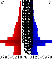
Demographics
Census
A census is the procedure of systematically acquiring and recording information about the members of a given population. It is a regularly occurring and official count of a particular population. The term is used mostly in connection with national population and housing censuses; other common...
of 2000, there were 62,843 people, 22,137 households, and 12,263 families residing in the county. The population density
Population density
Population density is a measurement of population per unit area or unit volume. It is frequently applied to living organisms, and particularly to humans...
was 103 people per square mile (40/km²). There were 23,397 housing units at an average density of 38 per square mile (15/km²). The racial makeup of the county was 84.78% White
Race (United States Census)
Race and ethnicity in the United States Census, as defined by the Federal Office of Management and Budget and the United States Census Bureau, are self-identification data items in which residents choose the race or races with which they most closely identify, and indicate whether or not they are...
, 6.88% Black
Race (United States Census)
Race and ethnicity in the United States Census, as defined by the Federal Office of Management and Budget and the United States Census Bureau, are self-identification data items in which residents choose the race or races with which they most closely identify, and indicate whether or not they are...
or African American
Race (United States Census)
Race and ethnicity in the United States Census, as defined by the Federal Office of Management and Budget and the United States Census Bureau, are self-identification data items in which residents choose the race or races with which they most closely identify, and indicate whether or not they are...
, 0.63% Native American
Race (United States Census)
Race and ethnicity in the United States Census, as defined by the Federal Office of Management and Budget and the United States Census Bureau, are self-identification data items in which residents choose the race or races with which they most closely identify, and indicate whether or not they are...
, 3.22% Asian
Race (United States Census)
Race and ethnicity in the United States Census, as defined by the Federal Office of Management and Budget and the United States Census Bureau, are self-identification data items in which residents choose the race or races with which they most closely identify, and indicate whether or not they are...
, 0.17% Pacific Islander
Race (United States Census)
Race and ethnicity in the United States Census, as defined by the Federal Office of Management and Budget and the United States Census Bureau, are self-identification data items in which residents choose the race or races with which they most closely identify, and indicate whether or not they are...
, 1.89% from other races
Race (United States Census)
Race and ethnicity in the United States Census, as defined by the Federal Office of Management and Budget and the United States Census Bureau, are self-identification data items in which residents choose the race or races with which they most closely identify, and indicate whether or not they are...
, and 2.43% from two or more races. 4.57% of the population were Hispanic
Race (United States Census)
Race and ethnicity in the United States Census, as defined by the Federal Office of Management and Budget and the United States Census Bureau, are self-identification data items in which residents choose the race or races with which they most closely identify, and indicate whether or not they are...
or Latino
Race (United States Census)
Race and ethnicity in the United States Census, as defined by the Federal Office of Management and Budget and the United States Census Bureau, are self-identification data items in which residents choose the race or races with which they most closely identify, and indicate whether or not they are...
of any race.
There were 22,137 households out of which 27.80% had children under the age of 18 living with them, 46.20% were married couples
Marriage
Marriage is a social union or legal contract between people that creates kinship. It is an institution in which interpersonal relationships, usually intimate and sexual, are acknowledged in a variety of ways, depending on the culture or subculture in which it is found...
living together, 6.80% had a female householder with no husband present, and 44.60% were non-families. 27.50% of all households were made up of individuals and 6.10% had someone living alone who was 65 years of age or older. The average household size was 2.42 and the average family size was 2.99.
In the county the population was spread out with 18.80% under the age of 18, 34.50% from 18 to 24, 25.90% from 25 to 44, 13.30% from 45 to 64, and 7.50% who were 65 years of age or older. The median age was 24 years. For every 100 females there were 114.30 males. For every 100 females age 18 and over, there were 115.40 males.
The median income for a household in the county was $32,042, and the median income for a family was $46,489. Males had a median income of $26,856 versus $23,835 for females. The per capita income
Per capita income
Per capita income or income per person is a measure of mean income within an economic aggregate, such as a country or city. It is calculated by taking a measure of all sources of income in the aggregate and dividing it by the total population...
for the county was $16,349. About 8.50% of families and 20.60% of the population were below the poverty line, including 11.20% of those under age 18 and 6.70% of those age 65 or over.
Incorporated cities
Name and population (2004 estimate):- ManhattanManhattan, KansasManhattan is a city located in the northeastern part of the state of Kansas in the United States, at the junction of the Kansas River and Big Blue River. It is the county seat of Riley County and the city extends into Pottawatomie County. As of the 2010 census, the city population was 52,281...
, 47,916 (county seat) - OgdenOgden, KansasOgden is a city in Riley County, Kansas, United States. As of the 2010 census, the city population was 2,087. It is part of the Manhattan, Kansas Metropolitan Statistical Area.-History:...
, 1,544 - RileyRiley, KansasRiley is a city in Riley County, Kansas, United States. As of the 2010 census, the city population was TBD. It is part of the Manhattan, Kansas Metropolitan Statistical Area.-Geography:Riley is located at...
, 760 - LeonardvilleLeonardville, KansasLeonardville is a city in Riley County, Kansas, United States. As of the 2010 census, the city population was 449. It is part of the Manhattan, Kansas Metropolitan Statistical Area.-Geography:Leonardville is located at...
, 384 - RandolphRandolph, KansasRandolph is a city in Riley County, Kansas, United States. As of the 2010 census, the city population was 163. It is part of the Manhattan, Kansas Metropolitan Statistical Area.-History:Randolph was originally located a mile east of its present location....
, 149
Unincorporated places
- Ashland
- Bala
- Keats
- Lasita
- May Day
- Rocky Ford
- ZeandaleZeandale, KansasZeandale is an unincorporated community in Riley County, Kansas, United States. It is located east of Manhattan and is part of the Manhattan Metropolitan Statistical Area. The elevation of the community is above sea level. The total population of the township was 357 at the 2000 US census...
Former communities
These former places were flooded when Tuttle Creek LakeTuttle Creek Lake
Tuttle Creek Lake is a reservoir on the Big Blue River 5 miles north of Manhattan, in the Flint Hills region of northeast Kansas. It was built and is operated by the Army Corps of Engineers for the purpose of flood control....
was created in the 1950s and 1960s. Randolph
Randolph, Kansas
Randolph is a city in Riley County, Kansas, United States. As of the 2010 census, the city population was 163. It is part of the Manhattan, Kansas Metropolitan Statistical Area.-History:Randolph was originally located a mile east of its present location....
was also flooded, but moved a mile west of its original location.
- Cleburn
- Garrison Cross
- Stockdale
Fort Riley
Located north of the junction of the Smoky HillSmoky Hill River
The Smoky Hill River is a river in the central Great Plains of North America, running through the U.S. states of Colorado and Kansas.-Names:The Smoky Hill gets its name from the Smoky Hills region of north-central Kansas through which it flows...
and Republican
Republican River
The Republican River is a river in the central Great Plains of North America, flowing through the U.S. states of Nebraska and Kansas.-Geography:...
rivers in Geary County
Geary County, Kansas
Geary County is a county located in Northeast Kansas, in the Central United States. As of the 2010 census, the county population was 34,362. Its county seat and most populous city is Junction City. The county is named in honor of Governor John W. Geary...
, the Fort Riley
Fort Riley
Fort Riley is a United States Army installation located in Northeast Kansas, on the Kansas River, between Junction City and Manhattan. The Fort Riley Military Reservation covers 100,656 acres in Geary and Riley counties and includes two census-designated places: Fort Riley North and Fort...
Military Reservation covers 100656 acres (407 km²) in Geary and Riley counties. The fort has a daytime population of nearly 25,000 and includes two census-designated place
Census-designated place
A census-designated place is a concentration of population identified by the United States Census Bureau for statistical purposes. CDPs are delineated for each decennial census as the statistical counterparts of incorporated places such as cities, towns and villages...
s:
- Fort Riley NorthFort Riley North, KansasFort Riley North is a census-designated place that covers part of Fort Riley, a US Army installation in Geary and Riley counties in the U.S. state of Kansas. The area is more commonly known as "Custer Hill"...
- Fort Riley-Camp WhitesideFort Riley-Camp Whiteside, KansasFort Riley-Camp Whiteside is a census-designated place that covers part of Fort Riley, a US Army installation in Geary County, Kansas, United States...
(located only in Geary County)
Townships
Riley County is divided into fourteen townshipsCivil township
A civil township is a widely used unit of local government in the United States, subordinate to, and geographic divisions of, a county. Specific responsibilities and the degree of autonomy vary based on each state. Civil townships are distinct from survey townships, but in states that have both,...
. The city of Manhattan
Manhattan, Kansas
Manhattan is a city located in the northeastern part of the state of Kansas in the United States, at the junction of the Kansas River and Big Blue River. It is the county seat of Riley County and the city extends into Pottawatomie County. As of the 2010 census, the city population was 52,281...
is considered governmentally independent and is excluded from the census figures for the townships. In the following table, the population center is the largest city (or cities) included in that township's population total, if it is of a significant size.
| Township | FIPS | Population center |
Population | Population density /km² (/sq mi) |
Land area km² (sq mi) | Water area km² (sq mi) | Water % | Geographic coordinates |
|---|---|---|---|---|---|---|---|---|
| Ashland | 02725 | 150 | 2 (4) | 89 (35) | 1 (0) | 0.75% | 39°6′48"N 96°37′42"W | |
| Bala | 03825 | Leonardville Leonardville, Kansas Leonardville is a city in Riley County, Kansas, United States. As of the 2010 census, the city population was 449. It is part of the Manhattan, Kansas Metropolitan Statistical Area.-Geography:Leonardville is located at... |
762 | 7 (18) | 108 (42) | 0 (0) | 0.12% | 39°20′34"N 96°53′47"W |
| Center | 12100 | 81 | 1 (3) | 82 (32) | 0 (0) | 0.04% | 39°29′22"N 96°52′54"W | |
| Fancy Creek | 22950 | 126 | 2 (4) | 83 (32) | 0 (0) | 0.07% | 39°24′55"N 96°53′14"W | |
| Grant | 28075 | 833 | 9 (23) | 92 (35) | 7 (3) | 7.38% | 39°17′52"N 96°41′31"W | |
| Jackson | 34900 | Randolph Randolph, Kansas Randolph is a city in Riley County, Kansas, United States. As of the 2010 census, the city population was 163. It is part of the Manhattan, Kansas Metropolitan Statistical Area.-History:Randolph was originally located a mile east of its present location.... |
326 | 4 (10) | 84 (32) | 10 (4) | 10.30% | 39°26′43"N 96°45′1"W |
| Madison | 44125 | Fort Riley North CDP (part) Fort Riley North, Kansas Fort Riley North is a census-designated place that covers part of Fort Riley, a US Army installation in Geary and Riley counties in the U.S. state of Kansas. The area is more commonly known as "Custer Hill"... |
8,173 | 22 (58) | 366 (141) | 0 (0) | 0.11% | 39°15′32"N 96°50′26"W |
| Manhattan | 44275 | 3,275 | 37 (95) | 89 (35) | 3 (1) | 3.28% | 39°12′45"N 96°35′46"W | |
| May Day | 45225 | 78 | 1 (2) | 81 (31) | 0 (0) | 0.04% | 39°32′39"N 96°53′41"W | |
| Ogden | 52300 | Ogden Ogden, Kansas Ogden is a city in Riley County, Kansas, United States. As of the 2010 census, the city population was 2,087. It is part of the Manhattan, Kansas Metropolitan Statistical Area.-History:... |
2,423 | 69 (178) | 35 (14) | 1 (0) | 2.32% | 39°7′6"N 96°41′54"W |
| Sherman | 65075 | 524 | 7 (18) | 76 (29) | 5 (2) | 6.06% | 39°22′30"N 96°43′58"W | |
| Swede Creek | 69650 | 157 | 1 (3) | 125 (48) | 4 (1) | 3.00% | 39°32′24"N 96°42′9"W | |
| Wildcat | 79175 | 750 | 10 (25) | 77 (30) | 0 (0) | 0.10% | 39°13′26"N 96°42′28"W | |
| Zeandale | 80900 | 357 | 2 (6) | 154 (60) | 2 (1) | 0.97% | 39°7′39"N 96°27′19"W |
Colleges and universities
- Kansas State UniversityKansas State UniversityKansas State University, commonly shortened to K-State, is an institution of higher learning located in Manhattan, Kansas, in the United States...
- Manhattan Christian CollegeManhattan Christian CollegeManhattan Christian College is an institution of higher learning located in Manhattan, Kansas, USA. Manhattan Christian College was founded in 1927 as Christian Workers University. The name was changed to Manhattan Bible College in 1930...
- Manhattan Area Technical CollegeManhattan Area Technical College' is a technical college located in Manhattan, Kansas. The College offers Associate of Applied Science degrees in 9 disciplines, with Technical Certificate programs in many others. The school has been in continuous operation since 1965. Manhattan Area Technical College is fully accredited through...
Unified school districts
- Riley County USD 378
- Manhattan-Ogden USD 383
- Manhattan High SchoolManhattan High SchoolManhattan High School is a fully accredited public high school in Manhattan, Kansas, serving students in grades 9-12. It is part of the Unified School District No. 383. For the 2010–2011 school year, Manhattan High had an enrollment of 1,984 students....
- Manhattan High School
- Blue Valley USD 384
See also
- Pillsbury CrossingPillsbury CrossingPillsbury Crossing is a natural limestone slab that was used by pioneers to cross Deep Creek. The ledge terminates in a waterfall in Riley County, Kansas, USA. The waterfall is about wide and has a drop of around...
- National Register of Historic Places listings in Riley County, KansasNational Register of Historic Places listings in Riley County, KansasThis is a list of the National Register of Historic Places listings in Riley County, Kansas.This is intended to be a complete list of the properties and districts on the National Register of Historic Places in Riley County, Kansas, United States...
Further reading
- History of the State of Kansas; William G. Cutler; A.T. Andreas Publisher; 1883. (Online HTML eBook)
- Kansas : A Cyclopedia of State History, Embracing Events, Institutions, Industries, Counties, Cities, Towns, Prominent Persons, Etc; 3 Volumes; Frank W. Blackmar; Standard Publishing Co; 944 / 955 / 824 pages; 1912. (Volume1 - Download 54MB PDF eBook), (Volume2 - Download 53MB PDF eBook), (Volume3 - Download 33MB PDF eBook)
External links
Official websitesGeneral county information
Local History and Genealogy
- List of 150 Notable Residents of Riley County
- The Irving, KS Tornado
- Cutler's History of Riley County, Kansas
- Riley County GenWeb
- Riley County Kansas AHGP
County Level Data
Maps
- Riley County Map, KDOT
- Kansas Highway Map, KDOT
- Kansas Railroad Map, KDOT
- Kansas School District Boundary Map, KSDE