
Washington County, Kansas
Encyclopedia
Washington County is a county
located in the U.S. state
of Kansas
. As of the 2010 census, the county population was 5,799. Its county seat
and largest town is the city of Washington
.
(Phase II) was constructed north to south through Washington County, with much controversy over tax exemption and environmental concerns (if a leak ever occurs).
, county until the Kansas Constitution was amended in 1986 and voters approved the sale of alcoholic liquor by the individual drink with a 30% food sales requirement.
 As of the census
of 2000, there were 6,483 people, 2,673 households, and 1,780 families residing in the county. The population density
was 7 people per square mile (3/km²). There were 3,142 housing units at an average density of 4 per square mile (1/km²). The racial makeup of the county was 98.90% White
, 0.11% Black
or African American
, 0.34% Native American
, 0.05% Asian
, 0.09% from other races
, and 0.51% from two or more races. 0.65% of the population were Hispanic
or Latino
of any race.
There were 2,673 households out of which 26.60% had children under the age of 18 living with them, 59.40% were married couples
living together, 4.20% had a female householder with no husband present, and 33.40% were non-families. 31.20% of all households were made up of individuals and 17.80% had someone living alone who was 65 years of age or older. The average household size was 2.35 and the average family size was 2.96.
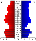
In the county the population was spread out with 23.70% under the age of 18, 5.40% from 18 to 24, 22.90% from 25 to 44, 23.00% from 45 to 64, and 25.10% who were 65 years of age or older. The median age was 44 years. For every 100 females there were 100.80 males. For every 100 females age 18 and over, there were 97.80 males.
The median income for a household in the county was $29,363, and the median income for a family was $37,260. Males had a median income of $25,074 versus $18,000 for females. The per capita income
for the county was $15,515. About 7.30% of families and 10.10% of the population were below the poverty line, including 12.20% of those under age 18 and 12.40% of those age 65 or over.
. The city of Washington
is considered governmentally independent and is excluded from the census figures for the townships. In the following table, the population center is the largest city (or cities) included in that township's population total, if it is of a significant size.
Maps
County (United States)
In the United States, a county is a geographic subdivision of a state , usually assigned some governmental authority. The term "county" is used in 48 of the 50 states; Louisiana is divided into parishes and Alaska into boroughs. Parishes and boroughs are called "county-equivalents" by the U.S...
located in the U.S. state
U.S. state
A U.S. state is any one of the 50 federated states of the United States of America that share sovereignty with the federal government. Because of this shared sovereignty, an American is a citizen both of the federal entity and of his or her state of domicile. Four states use the official title of...
of Kansas
Kansas
Kansas is a US state located in the Midwestern United States. It is named after the Kansas River which flows through it, which in turn was named after the Kansa Native American tribe, which inhabited the area. The tribe's name is often said to mean "people of the wind" or "people of the south...
. As of the 2010 census, the county population was 5,799. Its county seat
County seat
A county seat is an administrative center, or seat of government, for a county or civil parish. The term is primarily used in the United States....
and largest town is the city of Washington
Washington, Kansas
Washington is a city in and the county seat of Washington County, Kansas, United States. As of the 2010 census, the city population was 1,131.-Geography:Washington is...
.
21st century
In 2010, the Keystone-Cushing PipelineKeystone Pipeline
The Keystone Pipeline System is a pipeline system to transport synthetic crude oil and diluted bitumen from the Athabasca Oil Sands in northeastern Alberta, Canada to multiple destinations in the United States, which include refineries in Illinois, Cushing oil distribution hub in Oklahoma, and...
(Phase II) was constructed north to south through Washington County, with much controversy over tax exemption and environmental concerns (if a leak ever occurs).
Law and government
Washington County was a prohibition, or "dry"Dry county
A dry county is a county in the United States whose government forbids the sale of alcoholic beverages. Some prohibit off-premises sale, some prohibit on-premises sale, and some prohibit both. Hundreds of dry counties exist across the United States, almost all of them in the South...
, county until the Kansas Constitution was amended in 1986 and voters approved the sale of alcoholic liquor by the individual drink with a 30% food sales requirement.
Geography
According to the 2000 census, the county has a total area of 898.84 square miles (2,328 km²), of which 898.46 square miles (2,327 km²) (or 99.96%) is land and 0.38 square mile (0.9841954818 km²) (or 0.04%) is water.Adjacent counties
- Jefferson CountyJefferson County, Nebraska-Demographics:As of the census of 2000, there were 8,333 people, 3,527 households, and 2,352 families residing in the county. The population density was 14 people per square mile . There were 3,942 housing units at an average density of 7 per square mile...
, NebraskaNebraskaNebraska is a state on the Great Plains of the Midwestern United States. The state's capital is Lincoln and its largest city is Omaha, on the Missouri River....
(north) - Gage CountyGage County, Nebraska-History:Gage County was formed with land taken from the Oto in an 1854 treaty. It was named after the minister William D. Gage.-Demographics:As of the census of 2000, there were 22,993 people, 9,316 households, and 6,204 families residing in the county. The population density was 27 people per...
, NebraskaNebraskaNebraska is a state on the Great Plains of the Midwestern United States. The state's capital is Lincoln and its largest city is Omaha, on the Missouri River....
(northeast) - Marshall CountyMarshall County, KansasMarshall County is a county located in the U.S. state of Kansas. As of the 2010 census, the county population was 10,117. The largest city and county seat is Marysville.- History :...
(east) - Riley CountyRiley County, KansasRiley County is a county located in the U.S. state of Kansas. The county's population was 71,115 for the 2010 census. The largest city and county seat is Manhattan. The county is part of the Manhattan, Kansas, Metropolitan Statistical Area.Riley County is home to two of Kansas' largest...
(southeast) - Clay CountyClay County, KansasClay County is a county located in North Central Kansas, in the Central United States. As of the 2010 census, the county population was 8,535...
(south) - Cloud CountyCloud County, KansasCloud County is a county located in North Central Kansas, in the Central United States. As of the 2010 census, the county population was 9,533. Its county seat and most populous city is Concordia.-19th century:...
(southwest) - Republic CountyRepublic County, KansasRepublic County is a county located in the state of Kansas. As of the 2010 census, the county population was 4,980. The largest city and county seat is Belleville.-19th century:...
(west) - Thayer CountyThayer County, Nebraska-History:Thayer County was formed in 1872. It was named after the General and Governor John Milton Thayer.-Demographics:As of the census of 2000, there were 6,055 people, 2,541 households, and 1,689 families residing in the county. The population density was 10 people per square mile . There were...
, NebraskaNebraskaNebraska is a state on the Great Plains of the Midwestern United States. The state's capital is Lincoln and its largest city is Omaha, on the Missouri River....
(northwest)
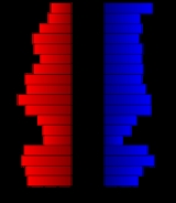
Demographics
Census
A census is the procedure of systematically acquiring and recording information about the members of a given population. It is a regularly occurring and official count of a particular population. The term is used mostly in connection with national population and housing censuses; other common...
of 2000, there were 6,483 people, 2,673 households, and 1,780 families residing in the county. The population density
Population density
Population density is a measurement of population per unit area or unit volume. It is frequently applied to living organisms, and particularly to humans...
was 7 people per square mile (3/km²). There were 3,142 housing units at an average density of 4 per square mile (1/km²). The racial makeup of the county was 98.90% White
Race (United States Census)
Race and ethnicity in the United States Census, as defined by the Federal Office of Management and Budget and the United States Census Bureau, are self-identification data items in which residents choose the race or races with which they most closely identify, and indicate whether or not they are...
, 0.11% Black
Race (United States Census)
Race and ethnicity in the United States Census, as defined by the Federal Office of Management and Budget and the United States Census Bureau, are self-identification data items in which residents choose the race or races with which they most closely identify, and indicate whether or not they are...
or African American
Race (United States Census)
Race and ethnicity in the United States Census, as defined by the Federal Office of Management and Budget and the United States Census Bureau, are self-identification data items in which residents choose the race or races with which they most closely identify, and indicate whether or not they are...
, 0.34% Native American
Race (United States Census)
Race and ethnicity in the United States Census, as defined by the Federal Office of Management and Budget and the United States Census Bureau, are self-identification data items in which residents choose the race or races with which they most closely identify, and indicate whether or not they are...
, 0.05% Asian
Race (United States Census)
Race and ethnicity in the United States Census, as defined by the Federal Office of Management and Budget and the United States Census Bureau, are self-identification data items in which residents choose the race or races with which they most closely identify, and indicate whether or not they are...
, 0.09% from other races
Race (United States Census)
Race and ethnicity in the United States Census, as defined by the Federal Office of Management and Budget and the United States Census Bureau, are self-identification data items in which residents choose the race or races with which they most closely identify, and indicate whether or not they are...
, and 0.51% from two or more races. 0.65% of the population were Hispanic
Race (United States Census)
Race and ethnicity in the United States Census, as defined by the Federal Office of Management and Budget and the United States Census Bureau, are self-identification data items in which residents choose the race or races with which they most closely identify, and indicate whether or not they are...
or Latino
Race (United States Census)
Race and ethnicity in the United States Census, as defined by the Federal Office of Management and Budget and the United States Census Bureau, are self-identification data items in which residents choose the race or races with which they most closely identify, and indicate whether or not they are...
of any race.
There were 2,673 households out of which 26.60% had children under the age of 18 living with them, 59.40% were married couples
Marriage
Marriage is a social union or legal contract between people that creates kinship. It is an institution in which interpersonal relationships, usually intimate and sexual, are acknowledged in a variety of ways, depending on the culture or subculture in which it is found...
living together, 4.20% had a female householder with no husband present, and 33.40% were non-families. 31.20% of all households were made up of individuals and 17.80% had someone living alone who was 65 years of age or older. The average household size was 2.35 and the average family size was 2.96.
In the county the population was spread out with 23.70% under the age of 18, 5.40% from 18 to 24, 22.90% from 25 to 44, 23.00% from 45 to 64, and 25.10% who were 65 years of age or older. The median age was 44 years. For every 100 females there were 100.80 males. For every 100 females age 18 and over, there were 97.80 males.
The median income for a household in the county was $29,363, and the median income for a family was $37,260. Males had a median income of $25,074 versus $18,000 for females. The per capita income
Per capita income
Per capita income or income per person is a measure of mean income within an economic aggregate, such as a country or city. It is calculated by taking a measure of all sources of income in the aggregate and dividing it by the total population...
for the county was $15,515. About 7.30% of families and 10.10% of the population were below the poverty line, including 12.20% of those under age 18 and 12.40% of those age 65 or over.
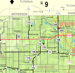
Incorporated cities
Name and population (2004 estimate):- WashingtonWashington, KansasWashington is a city in and the county seat of Washington County, Kansas, United States. As of the 2010 census, the city population was 1,131.-Geography:Washington is...
, 1,162 (county seat) - HanoverHanover, KansasHanover is a city in Washington County, Kansas, United States. As of the 2010 census, the city population was 682.-Geography:Hanover is located at . According to the United States Census Bureau, the city has a total area of , all of it land.-Demographics:As of the census of 2000, there were 653...
, 603 - CliftonClifton, KansasClifton is a city in Washington and Clay counties in the U.S. state of Kansas. As of the 2010 census, the city population was 554.-Geography:...
, 516, of which a portion lies in Clay CountyClay County, KansasClay County is a county located in North Central Kansas, in the Central United States. As of the 2010 census, the county population was 8,535... - LinnLinn, KansasLinn is a city in Washington County, Kansas, United States. As of the 2010 census, the city population was 410.-Geography:Linn is located at . According to the United States Census Bureau, the city has a total area of , all of it land.-Demographics:As of the census of 2000, there were 425 people,...
, 395 - GreenleafGreenleaf, KansasGreenleaf is a city in Washington County, Kansas, United States. As of the 2010 census, the city population was 331.-Geography:Greenleaf is located at...
, 333 - HaddamHaddam, KansasHaddam is a city in Washington County, Kansas, United States. It is named after Haddam, Connecticut. As of the 2010 census, the city population was 104.-Geography:Haddam is located at...
, 160 - MorrowvilleMorrowville, KansasMorrowville is a city in Washington County, Kansas, United States. As of the 2010 census, the city population was 155.-Geography:Morrowville is located at . According to the United States Census Bureau, the city has a total area of , all of it land.-Area attractions:*...
, 159 - BarnesBarnes, KansasBarnes is a city in Washington County, Kansas, United States. As of the 2010 census, the city population was 159.-Geography:Barnes is located at . According to the United States Census Bureau, the city has a total area of , all of it land.-Demographics:As of the census of 2000, there were 152...
, 144 - PalmerPalmer, KansasPalmer is a city in Washington County, Kansas, United States. As of the 2010 census, the city population was 111.-Geography:Palmer is located at . According to the United States Census Bureau, the city has a total area of , all of it land.-Demographics:As of the census of 2000, there were 108...
, 102 - MahaskaMahaska, KansasMahaska is a city in Washington County, Kansas, United States. As of the 2010 census, the city population was 83.-Geography:Mahaska is located at . According to the United States Census Bureau, the city has a total area of , all of it land.-Demographics:As of the census of 2000, there were 107...
, 101 - ViningVining, KansasVining is a city in Clay and Washington counties in Kansas, United States. As of the 2010 census, the city population was 45.-Geography:Vining is located at . According to the United States Census Bureau, the city has a total area of 0.2 square miles , all land...
, 56, of which a portion lies in Clay CountyClay County, KansasClay County is a county located in North Central Kansas, in the Central United States. As of the 2010 census, the county population was 8,535... - HollenbergHollenberg, KansasHollenberg is a city in Washington County, Kansas, United States. As of the 2010 census, the city population was 21.-Geography:Hollenberg is located at . According to the United States Census Bureau, the city has a total area of , all of it land.-Demographics:As of the census of 2000, there were...
, 29
Townships
Washington County is divided into twenty-five townshipsCivil township
A civil township is a widely used unit of local government in the United States, subordinate to, and geographic divisions of, a county. Specific responsibilities and the degree of autonomy vary based on each state. Civil townships are distinct from survey townships, but in states that have both,...
. The city of Washington
Washington, Kansas
Washington is a city in and the county seat of Washington County, Kansas, United States. As of the 2010 census, the city population was 1,131.-Geography:Washington is...
is considered governmentally independent and is excluded from the census figures for the townships. In the following table, the population center is the largest city (or cities) included in that township's population total, if it is of a significant size.
| Township | FIPS | Population center |
Population | Population density /km² (/sq mi) |
Land area km² (sq mi) | Water area km² (sq mi) | Water % | Geographic coordinates |
|---|---|---|---|---|---|---|---|---|
| Barnes | 04275 | 233 | 3 (6) | 93 (36) | 0 (0) | 0 % | 39°41′59"N 96°51′41"W | |
| Brantford | 08250 | 91 | 1 (3) | 93 (36) | 0 (0) | 0 % | 39°42′0"N 97°19′19"W | |
| Charleston | 12625 | 99 | 1 (3) | 93 (36) | 0 (0) | 0.03% | 39°52′36"N 96°58′54"W | |
| Clifton | 14225 | 459 | 5 (13) | 94 (36) | 0 (0) | 0 % | 39°35′19"N 97°18′11"W | |
| Coleman | 14750 | 64 | 1 (2) | 94 (36) | 0 (0) | 0 % | 39°46′39"N 97°11′24"W | |
| Farmington | 23275 | 192 | 2 (5) | 94 (36) | 0 (0) | 0 % | 39°51′52"N 97°6′1"W | |
| Franklin | 24525 | 139 | 2 (4) | 92 (36) | 0 (0) | 0.24% | 39°57′33"N 96°59′20"W | |
| Grant | 28175 | 25 | 0 (1) | 93 (36) | 0 (0) | 0 % | 39°46′24"N 97°19′21"W | |
| Greenleaf | 28650 | 450 | 5 (13) | 93 (36) | 0 (0) | 0 % | 39°42′33"N 96°59′5"W | |
| Haddam | 29425 | 246 | 3 (7) | 93 (36) | 0 (0) | 0 % | 39°51′51"N 97°18′28"W | |
| Hanover | 29900 | 884 | 9 (25) | 93 (36) | 0 (0) | 0.05% | 39°52′54"N 96°52′10"W | |
| Highland | 32025 | 22 | 0 (1) | 92 (36) | 0 (0) | 0.45% | 39°57′16"N 97°5′30"W | |
| Independence | 33950 | 169 | 2 (5) | 93 (36) | 0 (0) | 0.03% | 39°57′28"N 96°51′50"W | |
| Kimeo | 36850 | 75 | 1 (2) | 93 (36) | 0 (0) | 0 % | 39°36′11"N 96°57′57"W | |
| Lincoln | 41250 | 84 | 1 (2) | 93 (36) | 0 (0) | 0 % | 39°37′2"N 96°51′12"W | |
| Linn | 41450 | 599 | 6 (17) | 93 (36) | 0 (0) | 0.03% | 39°41′5"N 97°5′16"W | |
| Little Blue | 41500 | 93 | 1 (3) | 93 (36) | 0 (0) | 0.09% | 39°46′38"N 96°51′59"W | |
| Logan | 42300 | 109 | 1 (3) | 92 (36) | 0 (0) | 0.05% | 39°47′11"N 96°57′56"W | |
| Lowe | 43025 | 76 | 1 (2) | 92 (36) | 0 (0) | 0 % | 39°57′29"N 97°12′5"W | |
| Mill Creek | 46750 | 274 | 3 (8) | 94 (36) | 0 (0) | 0 % | 39°52′4"N 97°11′20"W | |
| Sheridan | 64775 | 119 | 1 (3) | 93 (36) | 0 (0) | 0 % | 39°37′3"N 97°11′19"W | |
| Sherman | 65125 | 249 | 3 (7) | 93 (36) | 0 (0) | 0 % | 39°37′2"N 97°6′3"W | |
| Strawberry | 68550 | 130 | 1 (4) | 94 (36) | 0 (0) | 0 % | 39°41′32"N 97°12′30"W | |
| Union | 72475 | 161 | 2 (5) | 92 (36) | 0 (0) | 0.04% | 39°57′58"N 97°19′30"W | |
| Washington | 75850 | 218 | 2 (6) | 91 (35) | 0 (0) | 0.04% | 39°47′12"N 97°4′38"W |
Education
The county is served by:Washington County Schools USD 108
The superintendent is Michael D. Stegman. It includes:- West Elementary School (Principal:Ron Scott)
- East Elementary School (Principal: Ron Scott)
- Washington County Junior High/High School (Principal: Phil Wilson).
Further reading
- History of the State of Kansas; William G. Cutler; A.T. Andreas Publisher; 1883. (Online HTML eBook)
- Kansas : A Cyclopedia of State History, Embracing Events, Institutions, Industries, Counties, Cities, Towns, Prominent Persons, Etc; 3 Volumes; Frank W. Blackmar; Standard Publishing Co; 944 / 955 / 824 pages; 1912. (Volume1 - Download 54MB PDF eBook),(Volume2 - Download 53MB PDF eBook), (Volume3 - Download 33MB PDF eBook)
External links
OfficialMaps
- Washington County Map, KDOT
- Kansas Highway Map, KDOT
- Kansas Railroad Map, KDOT
- Kansas School District Boundary Map, KSDE