
Riegelsville, Pennsylvania
Encyclopedia
Riegelsville is a borough in Bucks County
, Pennsylvania
, United States
. The population was 868 at the 2010 census.
, was named after Buckinghamshire, England.
Bucks County became the setting for George Washington
and his troops to cross the Delaware River and attack Trenton, NJ. Catching the enemy by surprise, it was the turning point of the American War of Independence.
With the completion of the Delaware Canal in 1832, the lands along the Delaware River
attracted great industrial development. The movement of coal, a major important product of the area, brought capital & investment to Easton. Boats carried coal, stone, iron, crops and goods from the mills along the 60 miles from Easton to Bristol. Along Canal Street grew one of the largest industrial manufacturing centers of America during the 1830s and 40s. Easton continued to prosper as a center for industry, manufacturing, commerce, and culture at the Forks of the Delaware and along the great rail lines. Riegelsville prospered when the Delaware Canal opened in 1832 with warehouses and factories lining its banks. The canal closed in 1931 after 99 years of service and was replaced by the railroads.
Today, Riegelsville is a peaceful and quiet town. Woods and fields border the Delaware Canal; remnants of crumbling stone foundations along its banks are reminders of a busy past.
Riegelsville, Pennsylvania was a mill town in the late 1880s and 1900s. The borough overlooks the Delaware River
spanned by a 1904 Roebling bridge with a walkway crossing to New Jersey. Residences built by Riegel Paper Company executives in the late 1880s along "Mansions Row" have been restored.
The Roebling Bridge, situated in Riegelsville, is one of the approximately three dozen bridges (along with other historic bridges such as Washington’s Cross and New Hope’s Lambertville bridge) spanning the Delaware River between Pennsylvania and New Jersey
.
According to the United States Census Bureau
, the borough has a total area of 1 square miles (2.6 km²), of which, 1 square miles (2.6 km²) of it is land and 0.1 square mile (0.258998811 km²) of it (5.71%) is water.
of 2000, there were 863 people, 378 households, and 250 families residing in the borough. The population density
was 867.8 people per square mile (336.6/km²). There were 403 housing units at an average density of 405.3 per square mile (157.2/km²). The racial makeup of the borough was 99.19% White, 0.12% African American, 0.23% Asian, 0.35% from other races
, and 0.12% from two or more races. Hispanic or Latino of any race were 0.58% of the population.
There were 378 households out of which 26.5% had children under the age of 18 living with them, 51.6% were married couples
living together, 10.1% had a female householder with no husband present, and 33.6% were non-families. 28.3% of all households were made up of individuals and 12.2% had someone living alone who was 65 years of age or older. The average household size was 2.28 and the average family size was 2.77.
In the borough the population was spread out with 21.3% under the age of 18, 5.2% from 18 to 24, 32.9% from 25 to 44, 25.0% from 45 to 64, and 15.5% who were 65 years of age or older. The median age was 40 years. For every 100 females there were 100.2 males. For every 100 females age 18 and over, there were 93.4 males.
The median income for a household in the borough was $48,194, and the median income for a family was $55,208. Males had a median income of $41,250 versus $31,726 for females. The per capita income
for the borough was $24,916. About 2.0% of families and 3.3% of the population were below the poverty line, including 1.2% of those under age 18 and 6.7% of those age 65 or over.
Bucks County, Pennsylvania
- Industry and commerce :The boroughs of Bristol and Morrisville were prominent industrial centers along the Northeast Corridor during World War II. Suburban development accelerated in Lower Bucks in the 1950s with the opening of Levittown, Pennsylvania, the second such "Levittown" designed by...
, Pennsylvania
Pennsylvania
The Commonwealth of Pennsylvania is a U.S. state that is located in the Northeastern and Mid-Atlantic regions of the United States. The state borders Delaware and Maryland to the south, West Virginia to the southwest, Ohio to the west, New York and Ontario, Canada, to the north, and New Jersey to...
, United States
United States
The United States of America is a federal constitutional republic comprising fifty states and a federal district...
. The population was 868 at the 2010 census.
History
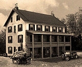
Benjamin Riegel founded Riegelsville. The original, and now historic, Riegelsville Inn that he built in 1838 still stands. This historic stone inn has offered food and lodging to Bucks County travelers for over 160 years. The community was named for the Riegel family, as early landowners; they established paper mills across the river in New JerseyBucks County and Riegelsville history
Bucks County, one of the three original counties in PennsylvaniaPennsylvania
The Commonwealth of Pennsylvania is a U.S. state that is located in the Northeastern and Mid-Atlantic regions of the United States. The state borders Delaware and Maryland to the south, West Virginia to the southwest, Ohio to the west, New York and Ontario, Canada, to the north, and New Jersey to...
, was named after Buckinghamshire, England.
Bucks County became the setting for George Washington
George Washington
George Washington was the dominant military and political leader of the new United States of America from 1775 to 1799. He led the American victory over Great Britain in the American Revolutionary War as commander-in-chief of the Continental Army from 1775 to 1783, and presided over the writing of...
and his troops to cross the Delaware River and attack Trenton, NJ. Catching the enemy by surprise, it was the turning point of the American War of Independence.
With the completion of the Delaware Canal in 1832, the lands along the Delaware River
Delaware River
The Delaware River is a major river on the Atlantic coast of the United States.A Dutch expedition led by Henry Hudson in 1609 first mapped the river. The river was christened the South River in the New Netherland colony that followed, in contrast to the North River, as the Hudson River was then...
attracted great industrial development. The movement of coal, a major important product of the area, brought capital & investment to Easton. Boats carried coal, stone, iron, crops and goods from the mills along the 60 miles from Easton to Bristol. Along Canal Street grew one of the largest industrial manufacturing centers of America during the 1830s and 40s. Easton continued to prosper as a center for industry, manufacturing, commerce, and culture at the Forks of the Delaware and along the great rail lines. Riegelsville prospered when the Delaware Canal opened in 1832 with warehouses and factories lining its banks. The canal closed in 1931 after 99 years of service and was replaced by the railroads.
Today, Riegelsville is a peaceful and quiet town. Woods and fields border the Delaware Canal; remnants of crumbling stone foundations along its banks are reminders of a busy past.
Riegelsville, Pennsylvania was a mill town in the late 1880s and 1900s. The borough overlooks the Delaware River
Delaware River
The Delaware River is a major river on the Atlantic coast of the United States.A Dutch expedition led by Henry Hudson in 1609 first mapped the river. The river was christened the South River in the New Netherland colony that followed, in contrast to the North River, as the Hudson River was then...
spanned by a 1904 Roebling bridge with a walkway crossing to New Jersey. Residences built by Riegel Paper Company executives in the late 1880s along "Mansions Row" have been restored.
The Roebling Bridge, situated in Riegelsville, is one of the approximately three dozen bridges (along with other historic bridges such as Washington’s Cross and New Hope’s Lambertville bridge) spanning the Delaware River between Pennsylvania and New Jersey
New Jersey
New Jersey is a state in the Northeastern and Middle Atlantic regions of the United States. , its population was 8,791,894. It is bordered on the north and east by the state of New York, on the southeast and south by the Atlantic Ocean, on the west by Pennsylvania and on the southwest by Delaware...
.
Geography
Riegelsville is located at 40°35′44"N 75°11′44"W (40.595429, -75.195679).According to the United States Census Bureau
United States Census Bureau
The United States Census Bureau is the government agency that is responsible for the United States Census. It also gathers other national demographic and economic data...
, the borough has a total area of 1 square miles (2.6 km²), of which, 1 square miles (2.6 km²) of it is land and 0.1 square mile (0.258998811 km²) of it (5.71%) is water.
Neighboring municipalities
- Durham Township (west and south)
- Holland Township, New JerseyHolland Township, New JerseyHolland Township is a township in Hunterdon County, New Jersey, United States. As of the United States 2010 Census, the township population was 5,291....
(southeast) - Pohatcong Township, New JerseyPohatcong Township, New JerseyPohatcong Township is a Township in Warren County, New Jersey, United States, located in the easternmost region of the Lehigh Valley. As of the 2010 United States Census, the township's population was 3,339....
(northeast) - Williams Township, Northampton CountyWilliams Township, Northampton County, PennsylvaniaWilliams Township is a township in Northampton County, Pennsylvania, United States. Williams Township is located in the Lehigh Valley region of the state.The population of Williams Township was 4,470 at the 2000 census.-History:...
(north)
Demographics
As of the censusCensus
A census is the procedure of systematically acquiring and recording information about the members of a given population. It is a regularly occurring and official count of a particular population. The term is used mostly in connection with national population and housing censuses; other common...
of 2000, there were 863 people, 378 households, and 250 families residing in the borough. The population density
Population density
Population density is a measurement of population per unit area or unit volume. It is frequently applied to living organisms, and particularly to humans...
was 867.8 people per square mile (336.6/km²). There were 403 housing units at an average density of 405.3 per square mile (157.2/km²). The racial makeup of the borough was 99.19% White, 0.12% African American, 0.23% Asian, 0.35% from other races
Race (United States Census)
Race and ethnicity in the United States Census, as defined by the Federal Office of Management and Budget and the United States Census Bureau, are self-identification data items in which residents choose the race or races with which they most closely identify, and indicate whether or not they are...
, and 0.12% from two or more races. Hispanic or Latino of any race were 0.58% of the population.
There were 378 households out of which 26.5% had children under the age of 18 living with them, 51.6% were married couples
Marriage
Marriage is a social union or legal contract between people that creates kinship. It is an institution in which interpersonal relationships, usually intimate and sexual, are acknowledged in a variety of ways, depending on the culture or subculture in which it is found...
living together, 10.1% had a female householder with no husband present, and 33.6% were non-families. 28.3% of all households were made up of individuals and 12.2% had someone living alone who was 65 years of age or older. The average household size was 2.28 and the average family size was 2.77.
In the borough the population was spread out with 21.3% under the age of 18, 5.2% from 18 to 24, 32.9% from 25 to 44, 25.0% from 45 to 64, and 15.5% who were 65 years of age or older. The median age was 40 years. For every 100 females there were 100.2 males. For every 100 females age 18 and over, there were 93.4 males.
The median income for a household in the borough was $48,194, and the median income for a family was $55,208. Males had a median income of $41,250 versus $31,726 for females. The per capita income
Per capita income
Per capita income or income per person is a measure of mean income within an economic aggregate, such as a country or city. It is calculated by taking a measure of all sources of income in the aggregate and dividing it by the total population...
for the borough was $24,916. About 2.0% of families and 3.3% of the population were below the poverty line, including 1.2% of those under age 18 and 6.7% of those age 65 or over.