

Reversed map
Encyclopedia
Map
A map is a visual representation of an area—a symbolic depiction highlighting relationships between elements of that space such as objects, regions, and themes....
where south is up, north is down, east is left and west is right. Thus the Southern Hemisphere
Southern Hemisphere
The Southern Hemisphere is the part of Earth that lies south of the equator. The word hemisphere literally means 'half ball' or "half sphere"...
at the top of the map instead of the bottom. These maps are just as accurate as traditionally oriented maps, because the position of North at the top of maps is arbitrary. Such maps have been made in several cultures and time periods. The convention that North is at the top (and East at the right) on most modern maps was established by the astronomer
Astronomer
An astronomer is a scientist who studies celestial bodies such as planets, stars and galaxies.Historically, astronomy was more concerned with the classification and description of phenomena in the sky, while astrophysics attempted to explain these phenomena and the differences between them using...
Ptolemy
Ptolemy
Claudius Ptolemy , was a Roman citizen of Egypt who wrote in Greek. He was a mathematician, astronomer, geographer, astrologer, and poet of a single epigram in the Greek Anthology. He lived in Egypt under Roman rule, and is believed to have been born in the town of Ptolemais Hermiou in the...
and was adopted by other cartographers.
In modern times, reversed maps are made as a learning device or to illustrate Northern Hemisphere
Northern Hemisphere
The Northern Hemisphere is the half of a planet that is north of its equator—the word hemisphere literally means “half sphere”. It is also that half of the celestial sphere north of the celestial equator...
bias. Different from simply turning a north-up map upside down, a reversed map has the text oriented to be read with south up. Uruguayan constructivist
Constructivism (art)
Constructivism was an artistic and architectural philosophy that originated in Russia beginning in 1919, which was a rejection of the idea of autonomous art. The movement was in favour of art as a practice for social purposes. Constructivism had a great effect on modern art movements of the 20th...
artist Joaquín Torres García
Joaquín Torres García
Joaquín Torres García , was a Uruguayan plastic artist and art theorist, also known as the founder of Constructive Universalism...
created several works depicting a map of South America
South America
South America is a continent situated in the Western Hemisphere, mostly in the Southern Hemisphere, with a relatively small portion in the Northern Hemisphere. The continent is also considered a subcontinent of the Americas. It is bordered on the west by the Pacific Ocean and on the north and east...
with the southern point at the top.
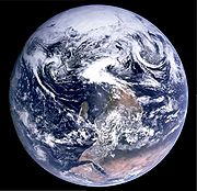
The famous "Blue Marble
The Blue Marble
The Blue Marble is a famous photograph of the Earth taken on December 7, 1972, by the crew of the Apollo 17 spacecraft at a distance of about ....
" photograph of the Earth taken from on board Apollo 17
Apollo 17
Apollo 17 was the eleventh and final manned mission in the American Apollo space program. Launched at 12:33 a.m. EST on December 7, 1972, with a three-member crew consisting of Commander Eugene Cernan, Command Module Pilot Ronald Evans, and Lunar Module Pilot Harrison Schmitt, Apollo 17 remains the...
was originally oriented with the south pole at the top, with the island of Madagascar
Madagascar
The Republic of Madagascar is an island country located in the Indian Ocean off the southeastern coast of Africa...
visible just left of center, and the continent of Africa
Africa
Africa is the world's second largest and second most populous continent, after Asia. At about 30.2 million km² including adjacent islands, it covers 6% of the Earth's total surface area and 20.4% of the total land area...
at its right. However, the image was turned upside-down to fit the traditional view.
Reversed maps often have Indonesia
Indonesia
Indonesia , officially the Republic of Indonesia , is a country in Southeast Asia and Oceania. Indonesia is an archipelago comprising approximately 13,000 islands. It has 33 provinces with over 238 million people, and is the world's fourth most populous country. Indonesia is a republic, with an...
placed in the center while Europe
Europe
Europe is, by convention, one of the world's seven continents. Comprising the westernmost peninsula of Eurasia, Europe is generally 'divided' from Asia to its east by the watershed divides of the Ural and Caucasus Mountains, the Ural River, the Caspian and Black Seas, and the waterways connecting...
and the Americas
Americas
The Americas, or America , are lands in the Western hemisphere, also known as the New World. In English, the plural form the Americas is often used to refer to the landmasses of North America and South America with their associated islands and regions, while the singular form America is primarily...
are placed to the sides, although there are reversed maps centered on the Prime Meridian
Prime Meridian
The Prime Meridian is the meridian at which the longitude is defined to be 0°.The Prime Meridian and its opposite the 180th meridian , which the International Date Line generally follows, form a great circle that divides the Earth into the Eastern and Western Hemispheres.An international...
. Ordinary north-up maps in East Asia also often have the Americas on the right, showing the Pacific ocean
Pacific Ocean
The Pacific Ocean is the largest of the Earth's oceanic divisions. It extends from the Arctic in the north to the Southern Ocean in the south, bounded by Asia and Australia in the west, and the Americas in the east.At 165.2 million square kilometres in area, this largest division of the World...
whole while cutting through the Atlantic ocean
Atlantic Ocean
The Atlantic Ocean is the second-largest of the world's oceanic divisions. With a total area of about , it covers approximately 20% of the Earth's surface and about 26% of its water surface area...
.
There are many other maps with non-standard orientation, such as medieval T and O map
T and O map
A T and O map or O-T or T-O map , is a type of medieval world map, sometimes also called a Beatine map or a Beatus map because one of the earliest known representations of this sort is attributed to Beatus of Liébana, an 8th-century Spanish monk...
s, polar maps, and Dymaxion map
Dymaxion map
The Dymaxion map or Fuller map is a projection of a world map onto the surface of a polyhedron, which can be unfolded and flattened to two dimensions. The projection depicts the earth's continents as "one island," or nearly contiguous land masses. The arrangement heavily interrupts the map in order...
s.
The psychological significance of reversed maps
An article by Meier, Moller, Chen, and Riemer-Peltz (2011), published in the journal Social Psychological and Personality Science, explored some of the psychological and behavioral consequences of consistently orienting maps such that north is up, and south is down (i.e., the north-south bias). Across 4 experiments, the authors demonstrated that due to affective associations between vertical position and valence (up = good, down = bad), participants tended to irrationally favor real estate positioned to the north (north=good, south=bad). When an imaginary city map was oriented such that north was at the top of the page, the average participant expressed a preference for living north of that city's center, and guessed that a hypothetical person described as high in socioeconomic status (SES) would also live north of the city's center (whereas someone low in SES would likely live significantly south of the city's center).In Study 3, one group of participants was shown a map of an imaginary city oriented in the traditional manner (north at the top; south at the bottom); a second group of participants was shown the same map with the orientation reversed (i.e., south at the top; north at the bottom). All participants were asked to place an 'x' on the map where they would prefer to live if moving to this imaginary city. Those in the first group with a traditional orientation, on average, selected a position significantly north of the city's center (replicating Study 2). For the second group shown a map with a reversed orientation (south at the top), there was a nonsignificant trend toward selected a position south of the city's center. Regardless of orientation, in both groups the trend was for people to prefer a location toward the top of the map, an indication that map orientation is driving the observed north-south bias.