
Rawlins County, Kansas
Encyclopedia
Rawlins County is a county located in the U.S. state
of Kansas
. As of the 2010 census, the county population was 2,519. The largest city and county seat
is Atwood
. It was named after Union
Civil War
General
John Aaron Rawlins
.
, county until 2002, when voters approved the sale of alcoholic liquor by the individual drink with a 30% food sales requirement.
. It has favored the Republican candidate for President in each of the last eighteen elections. The last Democrat to carry the county was Franklin D. Roosevelt
in 1936. In the last five Presidential elections the Democratic candidate has never received more than 21% of the county's vote.
 As of the census
of 2000, there were 2,966 people, 1,269 households, and 846 families residing in the county. The population density
was 3 people per square mile (1/km²). There were 1,565 housing units at an average density of 2 per square mile (1/km²). The racial makeup of the county was 98.52% White
, 0.30% Black
or African American
, 0.30% Native American
, 0.10% Asian
, 0.07% from other races
, and 0.71% from two or more races. 0.81% of the population were Hispanic
or Latino
of any race.
There were 1,269 households out of which 27.50% had children under the age of 18 living with them, 59.50% were married couples
living together, 4.90% had a female householder with no husband present, and 33.30% were non-families. 31.40% of all households were made up of individuals and 17.60% had someone living alone who was 65 years of age or older. The average household size was 2.29 and the average family size was 2.88.
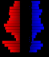
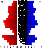
In the county the population was spread out with 24.00% under the age of 18, 3.80% from 18 to 24, 21.50% from 25 to 44, 25.10% from 45 to 64, and 25.60% who were 65 years of age or older. The median age was 45 years. For every 100 females there were 99.90 males. For every 100 females age 18 and over, there were 95.10 males.
The median income for a household in the county was $32,105, and the median income for a family was $40,074. Males had a median income of $26,719 versus $19,750 for females. The per capita income
for the county was $17,161. About 7.90% of families and 12.50% of the population were below the poverty line, including 18.00% of those under age 18 and 8.90% of those age 65 or over.
. None of the cities within the county are considered governmentally independent, and all figures for the townships include those of the cities. In the following table, the population center is the largest city (or cities) included in that township's population total, if it is of a significant size.
General county information
County Level Data
Maps
U.S. state
A U.S. state is any one of the 50 federated states of the United States of America that share sovereignty with the federal government. Because of this shared sovereignty, an American is a citizen both of the federal entity and of his or her state of domicile. Four states use the official title of...
of Kansas
Kansas
Kansas is a US state located in the Midwestern United States. It is named after the Kansas River which flows through it, which in turn was named after the Kansa Native American tribe, which inhabited the area. The tribe's name is often said to mean "people of the wind" or "people of the south...
. As of the 2010 census, the county population was 2,519. The largest city and county seat
County seat
A county seat is an administrative center, or seat of government, for a county or civil parish. The term is primarily used in the United States....
is Atwood
Atwood, Kansas
Atwood is a city in and the county seat of Rawlins County, Kansas, United States. As of the 2010 census, the city population was 1,194.-History:...
. It was named after Union
Union Army
The Union Army was the land force that fought for the Union during the American Civil War. It was also known as the Federal Army, the U.S. Army, the Northern Army and the National Army...
Civil War
American Civil War
The American Civil War was a civil war fought in the United States of America. In response to the election of Abraham Lincoln as President of the United States, 11 southern slave states declared their secession from the United States and formed the Confederate States of America ; the other 25...
General
General
A general officer is an officer of high military rank, usually in the army, and in some nations, the air force. The term is widely used by many nations of the world, and when a country uses a different term, there is an equivalent title given....
John Aaron Rawlins
John Aaron Rawlins
John Aaron Rawlins was an United States Army general during the American Civil War, a confidant of Ulysses S. Grant, and later U.S. Secretary of War.-Biography:...
.
Law and government
Following amendment to the Kansas Constitution in 1986, the county remained a prohibition, or "dry"Dry county
A dry county is a county in the United States whose government forbids the sale of alcoholic beverages. Some prohibit off-premises sale, some prohibit on-premises sale, and some prohibit both. Hundreds of dry counties exist across the United States, almost all of them in the South...
, county until 2002, when voters approved the sale of alcoholic liquor by the individual drink with a 30% food sales requirement.
Politics
The county is part of the highly Republican Kansas's 1st congressional districtKansas's 1st congressional district
Kansas's 1st congressional district is a congressional district in the U.S. state of Kansas. Commonly known as "The Big First," the district encompasses 69 counties in western and central Kansas , making it the 11th largest congressional district in the nation. A characteristically rural district,...
. It has favored the Republican candidate for President in each of the last eighteen elections. The last Democrat to carry the county was Franklin D. Roosevelt
Franklin D. Roosevelt
Franklin Delano Roosevelt , also known by his initials, FDR, was the 32nd President of the United States and a central figure in world events during the mid-20th century, leading the United States during a time of worldwide economic crisis and world war...
in 1936. In the last five Presidential elections the Democratic candidate has never received more than 21% of the county's vote.
Geography
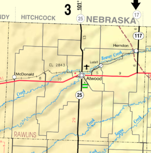
According to the 2000 census, the county has a total area of 1069.72 square miles (2,770.6 km²), of which 1069.62 square miles (2,770.3 km²) (or 99.99%) is land and 0.11 square mile (0.2848986921 km²) (or 0.01%) is water.Adjacent counties
- Hitchcock CountyHitchcock County, Nebraska-History:Hitchcock County was formed in 1873. It was named after the US Senator Phineas Warren Hitchcock.-Demographics:As of the census of 2000, there were 3,111 people, 1,287 households, and 899 families residing in the county. The population density was 4 people per square mile . There were...
, NebraskaNebraskaNebraska is a state on the Great Plains of the Midwestern United States. The state's capital is Lincoln and its largest city is Omaha, on the Missouri River....
(north) - Red Willow CountyRed Willow County, Nebraska-History:Red Willow County was formed in 1873. It was named after the Red Willow Creek.-Demographics:As of the census of 2000, there were 11,448 people, 4,710 households, and 3,188 families residing in the county. The population density was 16 people per square mile . There were 5,278 housing...
, NebraskaNebraskaNebraska is a state on the Great Plains of the Midwestern United States. The state's capital is Lincoln and its largest city is Omaha, on the Missouri River....
(northeast) - Decatur CountyDecatur County, KansasDecatur County is a county located in Northwest Kansas, in the Central United States. As of the 2010 census, the county population was 2,961. Its county seat and most populous city is Oberlin. The county is named in honor of Commodore Stephen Decatur, Jr.-History:The county was established...
(east) - Thomas CountyThomas County, KansasThomas County is a county located in the U.S. state of Kansas. As of the 2010 census, the county population was 7,900...
(south) - Sherman CountySherman County, KansasSherman County is a county located in the U.S. state of Kansas. As of the 2010 census, the county population was 6,010...
(southwest) - Cheyenne CountyCheyenne County, KansasCheyenne County is a county located in Northwest Kansas, in the Central United States. As of the 2010 census, the county population was 2,726. Its county seat and most populous city is St...
(west) - Dundy CountyDundy County, Nebraska-Demographics:As of the census of 2000, there were 2,292 people, 961 households, and 637 families residing in the county. The population density was 2 people per square mile . There were 1,196 housing units at an average density of 1 per square mile...
, NebraskaNebraskaNebraska is a state on the Great Plains of the Midwestern United States. The state's capital is Lincoln and its largest city is Omaha, on the Missouri River....
(northwest)
Demographics
Census
A census is the procedure of systematically acquiring and recording information about the members of a given population. It is a regularly occurring and official count of a particular population. The term is used mostly in connection with national population and housing censuses; other common...
of 2000, there were 2,966 people, 1,269 households, and 846 families residing in the county. The population density
Population density
Population density is a measurement of population per unit area or unit volume. It is frequently applied to living organisms, and particularly to humans...
was 3 people per square mile (1/km²). There were 1,565 housing units at an average density of 2 per square mile (1/km²). The racial makeup of the county was 98.52% White
Race (United States Census)
Race and ethnicity in the United States Census, as defined by the Federal Office of Management and Budget and the United States Census Bureau, are self-identification data items in which residents choose the race or races with which they most closely identify, and indicate whether or not they are...
, 0.30% Black
Race (United States Census)
Race and ethnicity in the United States Census, as defined by the Federal Office of Management and Budget and the United States Census Bureau, are self-identification data items in which residents choose the race or races with which they most closely identify, and indicate whether or not they are...
or African American
Race (United States Census)
Race and ethnicity in the United States Census, as defined by the Federal Office of Management and Budget and the United States Census Bureau, are self-identification data items in which residents choose the race or races with which they most closely identify, and indicate whether or not they are...
, 0.30% Native American
Race (United States Census)
Race and ethnicity in the United States Census, as defined by the Federal Office of Management and Budget and the United States Census Bureau, are self-identification data items in which residents choose the race or races with which they most closely identify, and indicate whether or not they are...
, 0.10% Asian
Race (United States Census)
Race and ethnicity in the United States Census, as defined by the Federal Office of Management and Budget and the United States Census Bureau, are self-identification data items in which residents choose the race or races with which they most closely identify, and indicate whether or not they are...
, 0.07% from other races
Race (United States Census)
Race and ethnicity in the United States Census, as defined by the Federal Office of Management and Budget and the United States Census Bureau, are self-identification data items in which residents choose the race or races with which they most closely identify, and indicate whether or not they are...
, and 0.71% from two or more races. 0.81% of the population were Hispanic
Race (United States Census)
Race and ethnicity in the United States Census, as defined by the Federal Office of Management and Budget and the United States Census Bureau, are self-identification data items in which residents choose the race or races with which they most closely identify, and indicate whether or not they are...
or Latino
Race (United States Census)
Race and ethnicity in the United States Census, as defined by the Federal Office of Management and Budget and the United States Census Bureau, are self-identification data items in which residents choose the race or races with which they most closely identify, and indicate whether or not they are...
of any race.
There were 1,269 households out of which 27.50% had children under the age of 18 living with them, 59.50% were married couples
Marriage
Marriage is a social union or legal contract between people that creates kinship. It is an institution in which interpersonal relationships, usually intimate and sexual, are acknowledged in a variety of ways, depending on the culture or subculture in which it is found...
living together, 4.90% had a female householder with no husband present, and 33.30% were non-families. 31.40% of all households were made up of individuals and 17.60% had someone living alone who was 65 years of age or older. The average household size was 2.29 and the average family size was 2.88.
In the county the population was spread out with 24.00% under the age of 18, 3.80% from 18 to 24, 21.50% from 25 to 44, 25.10% from 45 to 64, and 25.60% who were 65 years of age or older. The median age was 45 years. For every 100 females there were 99.90 males. For every 100 females age 18 and over, there were 95.10 males.
The median income for a household in the county was $32,105, and the median income for a family was $40,074. Males had a median income of $26,719 versus $19,750 for females. The per capita income
Per capita income
Per capita income or income per person is a measure of mean income within an economic aggregate, such as a country or city. It is calculated by taking a measure of all sources of income in the aggregate and dividing it by the total population...
for the county was $17,161. About 7.90% of families and 12.50% of the population were below the poverty line, including 18.00% of those under age 18 and 8.90% of those age 65 or over.
Incorporated cities
Name and population (2004 estimate):- AtwoodAtwood, KansasAtwood is a city in and the county seat of Rawlins County, Kansas, United States. As of the 2010 census, the city population was 1,194.-History:...
, 1,175 (county seat) - McDonaldMcDonald, KansasMcDonald is a city in Rawlins County, Kansas, United States. As of the 2010 census, the city population was 160.-Geography:McDonald is located at . According to the United States Census Bureau, the city has a total area of , all of it land.-Demographics:As of the census of 2000, there were 159...
, 144 - HerndonHerndon, KansasHerndon is a city in Rawlins County, Kansas, United States. As of the 2010 census, the city population was 129.-Geography:Herndon is located at . According to the United States Census Bureau, the city has a total area of , all of it land.-Demographics:As of the census of 2000, there were 149...
, 141
Townships
Rawlins County is divided into ten townshipsCivil township
A civil township is a widely used unit of local government in the United States, subordinate to, and geographic divisions of, a county. Specific responsibilities and the degree of autonomy vary based on each state. Civil townships are distinct from survey townships, but in states that have both,...
. None of the cities within the county are considered governmentally independent, and all figures for the townships include those of the cities. In the following table, the population center is the largest city (or cities) included in that township's population total, if it is of a significant size.
| Township | FIPS | Population center |
Population | Population density /km² (/sq mi) |
Land area km² (sq mi) | Water area km² (sq mi) | Water % | Geographic coordinates |
|---|---|---|---|---|---|---|---|---|
| Achilles | 00175 | 83 | 1 (2) | 132 (51) | 0 (0) | 0.02% | 39°42′13"N 100°48′38"W | |
| Atwood | 03175 | 1,330 | 74 (192) | 18 (7) | 0 (0) | 0.88% | 39°48′38"N 101°2′34"W | |
| Center | 12037 | 363 | 1 (1) | 690 (266) | 0 (0) | 0 % | 39°43′11"N 101°3′56"W | |
| Driftwood | 18675 | 84 | 0 (1) | 185 (72) | 0 (0) | 0 % | 39°57′56"N 101°4′59"W | |
| Herl | 31462 | 386 | 1 (2) | 491 (190) | 0 (0) | 0 % | 39°49′24"N 100°49′54"W | |
| Jefferson | 35300 | 34 | 0 (1) | 124 (48) | 0 (0) | 0.04% | 39°36′42"N 100°48′31"W | |
| Ludell | 43200 | 136 | 1 (4) | 92 (35) | 0 (0) | 0.01% | 39°51′30"N 100°57′1"W | |
| Mirage | 47175 | 43 | 0 (1) | 185 (71) | 0 (0) | 0 % | 39°38′53"N 101°14′2"W | |
| Rocewood | 60362 | 448 | 1 (2) | 742 (287) | 0 (0) | 0 % | 39°48′17"N 101°18′59"W | |
| Union | 72275 | 59 | 1 (1) | 111 (43) | 0 (0) | 0 % | 39°46′51"N 100°53′55"W |
Education
Further reading
- History of the State of Kansas; William G. Cutler; A.T. Andreas Publisher; 1883. (Online HTML eBook)
- Kansas : A Cyclopedia of State History, Embracing Events, Institutions, Industries, Counties, Cities, Towns, Prominent Persons, Etc; 3 Volumes; Frank W. Blackmar; Standard Publishing Co; 944 / 955 / 824 pages; 1912. (Volume1 - Download 54MB PDF eBook),(Volume2 - Download 53MB PDF eBook), (Volume3 - Download 33MB PDF eBook)
External links
OfficialGeneral county information
County Level Data
Maps
- Rawlins County Map, KDOT
- Kansas Highway Map, KDOT
- Kansas Railroad Map, KDOT
- Kansas School District Boundary Map, KSDE