
Rasletind
Encyclopedia
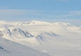
Rasletind is a mountain with two summits in Norway, the highest at 2105 m above sea level. It is located on the border between the municipalities of Vang and Vågå
, (in Oppland
), but the northwestern corner of the municipality of Øystre Slidre reaches the summit of Øystre Rasletind. It is the southeasternmost summits in the Jotunheimen
mountain area. It is situated on the western side of the high mountain plain of Valdresflyi. It is the eastern end of the long east-west-trending Kalvehøgde
massif. The summit can be observed from most of the mountain areas south and east of Jotunheimen
.
 The mountain have two summits, named Øystre Rasletind and Rasletind (Øystre meaning Eastern). The name probably derives from the Norwegian word for rumble "rasle" - the sound of stones falling down. The south wall of the summits is steep, so this makes the rumble-theory even more plausible. The name is also found in the tarn south of the summits and the smaller summit on the south end of the plain south of the summits is called Raslet.
Both summits are so close to the main route - later national route 51 - across Valdresflyi, so that it has been impossible to establish who was first to reach them. They are among the most easily available 2000-meter-summits in Norway.
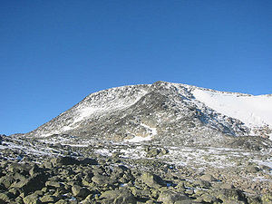
The mountain is among the southernmost 2000 m peaks in Norway and is made of the extremely hard gabbro
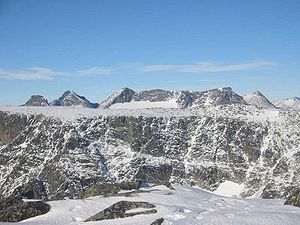
rock. The gabbro in Rasletind is of the normal "gray-with-black-specs" variety which can easily be observed on the slopes that are covered with snow most of the year and gives no support to lichen colonies. The view from the summits is one of the best in southern Norway
. On a clear day, you can see almost as far as Oslo
. You can see the Rondane range to the east-northeast and the Dovrefjell range to the north. Due south you see the summit of the beacon of Øystre Slidre
, Bitihorn
, and you also see the lakes of Vinstri and Bygdin
.
 The Eastern and Western summits can be reached after an easy hike, which, dependent on the choice of directness of the route will be of varying steepness. The following is a brief description of the trip. From the Youth Hostel at the highest point of National Route 51, hike directly towards the eastern summit. There are traces of a path on the wet meadowes on the south shore of lake Fisketjørni. Shortly after you leave the small lake, the very even route starts to climb, and you will not be able to see the summits any more.
Walk in a northwesterly direction until you reach the shoulder of the Raslet mountain. From here you can choose to hike directly towards the steep southeastern ridge. This ridge needs no equipment to be climbed, but it is steep. The easier choice is to hike towards the pass between the Eastern summit and the small summit on its eastern ridge. From here it is a rocky, but an easy hike to the summit. From the extremely flat eastern summit, it is easy to spot the route to the main summit. This short hike is no challenge except that it is rocky.
But the greatest number of people climb the hikes in April and May after the National Route 51 has opened again after winter. On a sunny Saturday or Sunday you will never walk alone, and the number of alternative routes is higher than in summer. Many peakbaggers continue to the Kalvehøgde
summits.
Vågå
Vågå is a municipality in Oppland county, Norway. It is part of the traditional region of Gudbrandsdal. The administrative centre of the municipality is the village of Vågåmo....
, (in Oppland
Oppland
is a county in Norway, bordering Sør-Trøndelag, Møre og Romsdal, Sogn og Fjordane, Buskerud, Akershus, Oslo and Hedmark. The county administration is in Lillehammer. Oppland is, together with Hedmark, one of the only two landlocked counties of Norway....
), but the northwestern corner of the municipality of Øystre Slidre reaches the summit of Øystre Rasletind. It is the southeasternmost summits in the Jotunheimen
Jotunheimen
Jotunheimen is a mountainous area of roughly 3,500 km² in Southern Norway and is part of the long range known as the Scandinavian Mountains. The 29 highest mountains in Norway are all in Jotunheimen, including the very highest - Galdhøpiggen...
mountain area. It is situated on the western side of the high mountain plain of Valdresflyi. It is the eastern end of the long east-west-trending Kalvehøgde
Kalvehøgde
Kalvehøgde is a 10 km long massif in the southernmost part of the Jotunheimen mountain range. The northern part of the massif lies within Jotunheimen National Park. The massif rises quite slowly from lake Bygdin, and ends in an extremely steep wall to the north. The wall is about 500 to 700 m...
massif. The summit can be observed from most of the mountain areas south and east of Jotunheimen
Jotunheimen
Jotunheimen is a mountainous area of roughly 3,500 km² in Southern Norway and is part of the long range known as the Scandinavian Mountains. The 29 highest mountains in Norway are all in Jotunheimen, including the very highest - Galdhøpiggen...
.
Both summits are so close to the main route - later national route 51 - across Valdresflyi, so that it has been impossible to establish who was first to reach them. They are among the most easily available 2000-meter-summits in Norway.
The mountain is among the southernmost 2000 m peaks in Norway and is made of the extremely hard gabbro
Gabbro
Gabbro refers to a large group of dark, coarse-grained, intrusive mafic igneous rocks chemically equivalent to basalt. The rocks are plutonic, formed when molten magma is trapped beneath the Earth's surface and cools into a crystalline mass....
rock. The gabbro in Rasletind is of the normal "gray-with-black-specs" variety which can easily be observed on the slopes that are covered with snow most of the year and gives no support to lichen colonies. The view from the summits is one of the best in southern Norway
Norway
Norway , officially the Kingdom of Norway, is a Nordic unitary constitutional monarchy whose territory comprises the western portion of the Scandinavian Peninsula, Jan Mayen, and the Arctic archipelago of Svalbard and Bouvet Island. Norway has a total area of and a population of about 4.9 million...
. On a clear day, you can see almost as far as Oslo
Oslo
Oslo is a municipality, as well as the capital and most populous city in Norway. As a municipality , it was established on 1 January 1838. Founded around 1048 by King Harald III of Norway, the city was largely destroyed by fire in 1624. The city was moved under the reign of Denmark–Norway's King...
. You can see the Rondane range to the east-northeast and the Dovrefjell range to the north. Due south you see the summit of the beacon of Øystre Slidre
Øystre Slidre
Øystre Slidre is a municipality in Oppland county, Norway. It is part of the traditional region of Valdres. The administrative centre of the municipality is the village of...
, Bitihorn
Bitihorn
Bitihorn is a mountain in the southernmost outskirts of Jotunheimen, Norway. It is situated due west of national route 51, and is therefore a landmark for tourists following that popular route.- Geology :...
, and you also see the lakes of Vinstri and Bygdin
Bygdin
Bygdin is a lake in the Jotunheimen mountain range. Bygdin is regulated and its normal level lies between 1,048 and 1,057 meters above sea level. It has an area of 46 km². The lake is long 25 km, but is narrow. The greatest depth is 215 m.Bygdin lies to the southeast in...
.
Walk in a northwesterly direction until you reach the shoulder of the Raslet mountain. From here you can choose to hike directly towards the steep southeastern ridge. This ridge needs no equipment to be climbed, but it is steep. The easier choice is to hike towards the pass between the Eastern summit and the small summit on its eastern ridge. From here it is a rocky, but an easy hike to the summit. From the extremely flat eastern summit, it is easy to spot the route to the main summit. This short hike is no challenge except that it is rocky.
But the greatest number of people climb the hikes in April and May after the National Route 51 has opened again after winter. On a sunny Saturday or Sunday you will never walk alone, and the number of alternative routes is higher than in summer. Many peakbaggers continue to the Kalvehøgde
Kalvehøgde
Kalvehøgde is a 10 km long massif in the southernmost part of the Jotunheimen mountain range. The northern part of the massif lies within Jotunheimen National Park. The massif rises quite slowly from lake Bygdin, and ends in an extremely steep wall to the north. The wall is about 500 to 700 m...
summits.