
Kalvehøgde
Encyclopedia
Kalvehøgde is a 10 km long massif in the southernmost part of the Jotunheimen
mountain range. The northern part of the massif lies within Jotunheimen National Park. The massif rises quite slowly from lake Bygdin
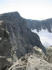
, and ends in an extremely steep wall to the north. The wall is about 500 to 700 m high. On the northern side of the massif, there are several glaciers, with Leirungsbrean as the greatest. On the southern slopes there are two smaller glaciers - the Kalveholobrean glaciers. All the glaciers have retreated in the later years.
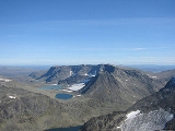
 The massif contains ten 2000 m summits, but the northwesternmost (in the foreground on the photo to the right) and the two easternmost (not visible) are normally seen as independent mountains. The prominence of most of the summits are less than 100 m, and most of the massif is a broad ridge or a plateau which makes it very popular among mountain skiers. The proximity to the National Route 51 adds to the popularity, and the massif is one of the definitely most visited in Jotunheimen.
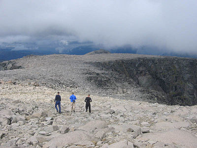
Because of the number of summits, there has been a need for more distinct names for all the seven summits, and the National Map Institute has decided upon the name Munken (the Monk) for the northeastern plateau - seen in the lowermost picture, Mugna (probably meaning huge) for the two central summits, Kalvehøgde (reindeer calf mountain) for the three western summits, and lastly Nordre Kalveholotind (northern reindeer calf hole peak) for the southwestern summit, which is the only summit which has a prominent, steep wall on the southern side of the massif.
The massif is built mostly by gabbro rocks, a hard and resistant rock. The southern slopes and the plateaus consist mostly of talus, and there is very little plant life except lichen, moss and ranunculus glacialis
. Snow sparrows and mountain grouses are frequent and reindeers can be seen, but they mostly prefer the grassy slopes down towards lake Bygdin.
 The Eastern Kalvehøgde and the Mugna summit were both climbed in 1820 by the two students Balthazar Mathias Keilhau and Peter Christian Bianco Boeck, both later prominent scientists at the university of Christiania. This is considered to be the first real mountain expedition in Norwegian history, and these summits were the first to be climbed by the two friends. The rest of the summits have unknown first ascents.
, the massif can be followed as far as Western Kalvehøgde, which is the highest summit with an elevation of 2208 m, but west of that summit, the plateau soon turns into a very steep and narrow edge, which needs equipment to be climbed. The southwestern summit of Nordre Kalveholotind and the northeastern summit of Munken branches off from the main massif, and they can be reached easily from the main massif. Mostly the massif is also easily accessible from lake Bygdin
, but that constitutes a rather long hike along the lake. From Torfinnsbu, where the boat Bitihorn has a landing, the massif can also be reached after a rather strenuous and steep hike.
The views from all the summits are great - since the massif is the southernmost and easternmost in Jotunheimen
.
' (of a reindeer
), the last element is the finite form of høgd f 'height
, mountain'.
Jotunheimen
Jotunheimen is a mountainous area of roughly 3,500 km² in Southern Norway and is part of the long range known as the Scandinavian Mountains. The 29 highest mountains in Norway are all in Jotunheimen, including the very highest - Galdhøpiggen...
mountain range. The northern part of the massif lies within Jotunheimen National Park. The massif rises quite slowly from lake Bygdin
Bygdin
Bygdin is a lake in the Jotunheimen mountain range. Bygdin is regulated and its normal level lies between 1,048 and 1,057 meters above sea level. It has an area of 46 km². The lake is long 25 km, but is narrow. The greatest depth is 215 m.Bygdin lies to the southeast in...
, and ends in an extremely steep wall to the north. The wall is about 500 to 700 m high. On the northern side of the massif, there are several glaciers, with Leirungsbrean as the greatest. On the southern slopes there are two smaller glaciers - the Kalveholobrean glaciers. All the glaciers have retreated in the later years.
Because of the number of summits, there has been a need for more distinct names for all the seven summits, and the National Map Institute has decided upon the name Munken (the Monk) for the northeastern plateau - seen in the lowermost picture, Mugna (probably meaning huge) for the two central summits, Kalvehøgde (reindeer calf mountain) for the three western summits, and lastly Nordre Kalveholotind (northern reindeer calf hole peak) for the southwestern summit, which is the only summit which has a prominent, steep wall on the southern side of the massif.
The massif is built mostly by gabbro rocks, a hard and resistant rock. The southern slopes and the plateaus consist mostly of talus, and there is very little plant life except lichen, moss and ranunculus glacialis
Ranunculus glacialis
Ranunculus glacialis, the glacier crowfoot or glacier buttercup, is a plant of the family Ranunculaceae.-Distribution:Ranunculus glacialis is an arctic-alpine species, found in the high mountains of southern Europe as well as on the Scandinavian peninsula, Iceland, the Faroe Islands, Jan Mayen,...
. Snow sparrows and mountain grouses are frequent and reindeers can be seen, but they mostly prefer the grassy slopes down towards lake Bygdin.
Brief hiking guide
The massif is easily accessible from National Route 51 crossing the Valdresflyi plateau. You reach the two summits of Rasletind, which is part of the massif but considered being a separate mountain. From the summit of the greater RasletindRasletind
Rasletind is a mountain with two summits in Norway, the highest at 2105 m above sea level. It is located on the border between the municipalities of Vang and Vågå, , but the northwestern corner of the municipality of Øystre Slidre reaches the summit of Øystre Rasletind. It is the southeasternmost...
, the massif can be followed as far as Western Kalvehøgde, which is the highest summit with an elevation of 2208 m, but west of that summit, the plateau soon turns into a very steep and narrow edge, which needs equipment to be climbed. The southwestern summit of Nordre Kalveholotind and the northeastern summit of Munken branches off from the main massif, and they can be reached easily from the main massif. Mostly the massif is also easily accessible from lake Bygdin
Bygdin
Bygdin is a lake in the Jotunheimen mountain range. Bygdin is regulated and its normal level lies between 1,048 and 1,057 meters above sea level. It has an area of 46 km². The lake is long 25 km, but is narrow. The greatest depth is 215 m.Bygdin lies to the southeast in...
, but that constitutes a rather long hike along the lake. From Torfinnsbu, where the boat Bitihorn has a landing, the massif can also be reached after a rather strenuous and steep hike.
The views from all the summits are great - since the massif is the southernmost and easternmost in Jotunheimen
Jotunheimen
Jotunheimen is a mountainous area of roughly 3,500 km² in Southern Norway and is part of the long range known as the Scandinavian Mountains. The 29 highest mountains in Norway are all in Jotunheimen, including the very highest - Galdhøpiggen...
.
The name
The first element is kalv m 'calfCalf
Calves are the young of domestic cattle. Calves are reared to become adult cattle, or are slaughtered for their meat, called veal.-Terminology:...
' (of a reindeer
Reindeer
The reindeer , also known as the caribou in North America, is a deer from the Arctic and Subarctic, including both resident and migratory populations. While overall widespread and numerous, some of its subspecies are rare and one has already gone extinct.Reindeer vary considerably in color and size...
), the last element is the finite form of høgd f 'height
Height
Height is the measurement of vertical distance, but has two meanings in common use. It can either indicate how "tall" something is, or how "high up" it is. For example "The height of the building is 50 m" or "The height of the airplane is 10,000 m"...
, mountain'.