
Bitihorn
Encyclopedia
Jotunheimen
Jotunheimen is a mountainous area of roughly 3,500 km² in Southern Norway and is part of the long range known as the Scandinavian Mountains. The 29 highest mountains in Norway are all in Jotunheimen, including the very highest - Galdhøpiggen...
, Norway
Norway
Norway , officially the Kingdom of Norway, is a Nordic unitary constitutional monarchy whose territory comprises the western portion of the Scandinavian Peninsula, Jan Mayen, and the Arctic archipelago of Svalbard and Bouvet Island. Norway has a total area of and a population of about 4.9 million...
. It is situated due west of national route 51, and is therefore a landmark for tourists following that popular route.
Geology
The mountain is steep towards south and east, and there is a subtle change in the rock layers between the sparagmiteSparagmite
Sparagmite is an Arkose sandstone or comglomerate so named by Jens Esmark in 1829. Deposited in the neoproterozoic to early Cambrian eras, the sparagmite nappes were transported up to several hundred kilometers during the Caledonian collision....
foundation and the summit which consists of the much harder gabbro
Gabbro
Gabbro refers to a large group of dark, coarse-grained, intrusive mafic igneous rocks chemically equivalent to basalt. The rocks are plutonic, formed when molten magma is trapped beneath the Earth's surface and cools into a crystalline mass....
rock. The summit is one of the southernmost outcrops of gabbro in the vicinity, and Bitihorn is therefore significantly higher than its neighbors to the south and east. Underneath the sparagmite layer, lies a layer of extremely nutritious slate, called phyllite
Phyllite
Phyllite is a type of foliated metamorphic rock primarily composed of quartz, sericite mica, and chlorite; the rock represents a gradation in the degree of metamorphism between slate and mica schist. Minute crystals of graphite, sericite, or chlorite impart a silky, sometimes golden sheen to the...
. That layer and its subsequent plant cover is the reason for the many mountain pastures in the area.
It is also quite easy to see how the different rock layers have been pushed upon each other from a north-northwest direction, so that the northern slope is quite easy, whereas the southern (and in this case the eastern) is extremely steep. This can be seen in all the neighboring peaks, like Skyrifjell, Heklefjell and Olefjell.
Tourism and WW II
In 1811 the peak was climbed for the first time in recorded history by the botanistBotany
Botany, plant science, or plant biology is a branch of biology that involves the scientific study of plant life. Traditionally, botany also included the study of fungi, algae and viruses...
Christen Smith
Christen Smith (botanist)
Christen Smith was a Norwegian physician, economist and naturalist, particularly botanist.-Early years:...
. Except for the expedition by Jens Esmark
Jens Esmark
Jens Esmark was a Danish-Norwegian professor of mineralogy who contributed to many of the initial discoveries and conceptual analyses of glaciers, specifically the concept that glaciers had covered larger areas in the past....
in 1798 this biological expedition was the first mountaineering effort in Norway. Smith also climbed the much higher Besshø
Besshø
Besshø , is a mountain in Vågå, Oppland, Norway, and is part of the Jotunheimen mountain range. It lies right above Bessvatnet, along the Besseggen hiking trail...
, further north.
Tourism soared in the late 19th century after the erection of Raudfjordheim lodge and later the hotels Bygdin
Bygdin
Bygdin is a lake in the Jotunheimen mountain range. Bygdin is regulated and its normal level lies between 1,048 and 1,057 meters above sea level. It has an area of 46 km². The lake is long 25 km, but is narrow. The greatest depth is 215 m.Bygdin lies to the southeast in...
and Bygdisheim in the vicinity. The extraordinary scenery attracted tourists from far away, among them queen Wilhelmine
Wilhelmine
Wilhelmine is a term for the period of German history, also known as the German Empire. The term Wilhelmine Germany refers to the period running from the proclamation of Wilhelm I as German Kaiser at Versailles in 1871 to the abdication of his grandson Wilhelm II in 1918.Although the father of...
of the Netherlands
Netherlands
The Netherlands is a constituent country of the Kingdom of the Netherlands, located mainly in North-West Europe and with several islands in the Caribbean. Mainland Netherlands borders the North Sea to the north and west, Belgium to the south, and Germany to the east, and shares maritime borders...
, who stayed at Bygdisheim. In 1905 the boat route on lake Bygdin
Bygdin
Bygdin is a lake in the Jotunheimen mountain range. Bygdin is regulated and its normal level lies between 1,048 and 1,057 meters above sea level. It has an area of 46 km². The lake is long 25 km, but is narrow. The greatest depth is 215 m.Bygdin lies to the southeast in...
(1060 m above sea level - different elevations can be found since the lake is dammed), was opened. The boat, which is aptly named Bitihorn, still traffics the route from Bygdin
Bygdin
Bygdin is a lake in the Jotunheimen mountain range. Bygdin is regulated and its normal level lies between 1,048 and 1,057 meters above sea level. It has an area of 46 km². The lake is long 25 km, but is narrow. The greatest depth is 215 m.Bygdin lies to the southeast in...
Hotel to Eidsbugarden
Eidsbugarden
Eidsbugarden is a tourist center which lies at the western end of Lake Bygdin in the Jotunheimen mountain range on the outskirts of Jotunheim National Park in Oppland, Norway. Eidsbugarden lies to the southeast in Jotunheim....
hotel in the western end for about ten weeks each summer. This was in the beginning of the 20th century a remarkable feat since there were no roads leading to the lake, but the boat was dragged there.
During WW II the steep east side was used by the German alpine troops for training. It is still possible to see at least one of the campsites used by them on the west side of the road. Earlier, until the 70s, paths of their mules could still be seen in the huge talus slope on the east side. The path is still there, but it is now made by sheep. Ruins of the mule stables, dug out in the soft soil on the east side of the road, are still visible. On the southern shoulder it is possible to find small one-man-shelters with holes for the guns. Some of these are probably built later as replicas, but some of them derives from 1941-1942.
Today
Bitihorn has become somewhat a symbolic sentry tower for the municipality of Øystre SlidreØystre Slidre
Øystre Slidre is a municipality in Oppland county, Norway. It is part of the traditional region of Valdres. The administrative centre of the municipality is the village of...
. It can be seen from most of the valley and the mountain plains on both sides. At the tourist resort, Beitostølen
Beitostølen
Beitostølen is a village in Øystre Slidre, Norway. As of 1 January 2009, it had 247 residents, and is located above mean sea level. It is largely a tourist area, with many cabins and hotels serving various winter sports facilities. The village has hosted FIS Cross-Country World Cup and Biathlon...
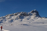
, which is only some km distant, it is used as the symbol of the tourist industry. The peak is climbed by an enormous number of tourists and locals during the summer season, mostly. It is easy to ascend from the north, even in the winter it is accessible.
It can also be climbed from the south, but good route knowledge is required in order to avoid technical climbing. From the northeast the route is well marked.
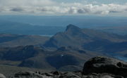
On the summit there is a huge antenna and a small cabin, which is closed to the public. The view from the summit is wonderful. To the south and east very little blocks the view to the rest of Valdres. To the north the Rasletind
Rasletind
Rasletind is a mountain with two summits in Norway, the highest at 2105 m above sea level. It is located on the border between the municipalities of Vang and Vågå, , but the northwestern corner of the municipality of Øystre Slidre reaches the summit of Øystre Rasletind. It is the southeasternmost...
, Kalvehøgde
Kalvehøgde
Kalvehøgde is a 10 km long massif in the southernmost part of the Jotunheimen mountain range. The northern part of the massif lies within Jotunheimen National Park. The massif rises quite slowly from lake Bygdin, and ends in an extremely steep wall to the north. The wall is about 500 to 700 m...
, Torfinnstindene
Torfinnstindene
Torfinnstindene is a mountain with three summits in Norway, the highest at 2120 m above sea level. It is located within the municipality of Vang, in the southernmost part of the Jotunheimen mountain area...
and Galdebergstind mountains dominates the view, and to the west you can see the forbidding spire of Falketind
Falketind
Falketind is a mountain in the municipality of Årdal in Sogn og Fjordane county, Norway. It is located in the Jotunheimen mountain range inside the Utladalen Landscape Protection Area. The mountain is east of the old mountain farm, Vettismorki, and northwest of the lake Tyin.The 1820 ascent was...
.