

Ramot Naftali
Encyclopedia
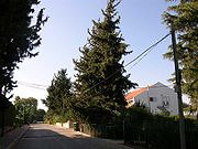
Moshav
Moshav is a type of Israeli town or settlement, in particular a type of cooperative agricultural community of individual farms pioneered by the Labour Zionists during the second aliyah...
in the Upper Galilee
Upper Galilee
The Upper Galilee is a geographical-political term in use since the end of the Second Temple period, originally referring to a mountainous area overlapping the present northern Israel and southern Lebanon, its borders being the Litani river in the north, the Mediterranean Sea in the west, the Beit...
in northern Israel
Israel
The State of Israel is a parliamentary republic located in the Middle East, along the eastern shore of the Mediterranean Sea...
, near Israel's border
Borders of Israel
Israel's borders are the borders of the State of Israel. The borders have changed from time to time with developments in Israel's military and diplomatic situation. It borders Lebanon in the north, Syria in the northeast, Jordan and the West Bank in the east, the Gaza Strip and Egypt on the...
with Lebanon
Lebanon
Lebanon , officially the Republic of LebanonRepublic of Lebanon is the most common term used by Lebanese government agencies. The term Lebanese Republic, a literal translation of the official Arabic and French names that is not used in today's world. Arabic is the most common language spoken among...
. It belongs to Mevo'ot HaHermon Regional Council
Mevo'ot HaHermon Regional Council
Mevo'ot HaHermon Regional Council is a Regional Council in the North District of Israel. It encompasses 13 Moshavim and Communal settlements, from the northern shore of the Kinneret, to the Lebanese border and Mount Hermon...
.
The community is named "Ramot Naftali" (hills of Naftali) because it is located in the mountains of Naftali, which was originally in the land owned by the Tribe of Naphtali
Tribe of Naphtali
The Tribe of Naphtali was one of the Tribes of Israel.Following the completion of the conquest of Canaan by the Israelite tribes after about 1200 BCE, Joshua allocated the land among the twelve tribes...
.
Lands belonging to the depopulated Palestinian village of Al-Nabi Yusha'
Al-Nabi Yusha'
-History:During the late eighteenth century, a family known as al-GhuI established the shrine for Nabi Yusha’ , which included a mosque and a building for visitors, as an act of devotion...
now constitue a part of the moshav. It is located close to the border between Al-Nabi Yusha' and the lands of the Palestinian village of Mallaha
Mallaha
Mallaha was a Palestinian Arab village, located northeast of Safed, on the highway between the latter and Tiberias. 'Ain Mallaha is the local Arabic name for a spring that served as the water source for the village inhabitants throughout the ages...
.
History
The community was founded in 1945 by a group of agricultural workers called "Bnei Peled" who were sent by national agencies to guard the land and prepare it for agriculture. After the end of World War IIWorld War II
World War II, or the Second World War , was a global conflict lasting from 1939 to 1945, involving most of the world's nations—including all of the great powers—eventually forming two opposing military alliances: the Allies and the Axis...
arrived the first group of discharged soldiers from two groups, "Wingate" and "HaMitnadev", who organized for settlement before they had joined the army.
The community was built around the fortress of Ramot Naftali, which was established together with the fortresses Biria and Hukok in 1945 as part of the defense of the British army in northern Israel, and in collaboration with the Jewish Agency. The fortresses were built by the construction company Solel Boneh
Solel Boneh
Solel Boneh is the oldest, and one of the largest, construction and civil engineering companies in Israel.-History:Solel Boneh was founded in 1921 during the first conference of the General Histadrut, under the name of Batz , an acronym of Binyan veAvodot Tziburiot . Its first project was to pave...
. The fortress today is part of a nearby army base, and it is used for guard-watching.
During the Israeli War of Independence the community was under fire for a long time, and it served as the focus of decisive battles from Lebanon
Lebanon
Lebanon , officially the Republic of LebanonRepublic of Lebanon is the most common term used by Lebanese government agencies. The term Lebanese Republic, a literal translation of the official Arabic and French names that is not used in today's world. Arabic is the most common language spoken among...
. Only after Operation Hiram
Operation Hiram
Operation Hiram was a military operation conducted by the Israel Defense Forces during the 1948 Arab-Israeli War. It was led by General Moshe Carmel, and aimed at capturing the upper Galilee region from the Arab Liberation Army forces led by Fawzi al-Qawuqji and a Syrian battalion...
did the attacks in the region cease.
In August 1963 a new nucleus of founders went to Kedesh Naftali, after the dispersal of the original members of the moshav. In the community two families remained from the first founding nucleus: Eliezer and Batya Kaufman and their three children, and the Adler family. Along with seven founders were: Ra'anan Naim
Ra'anan Naim
Ra'anan Naim 31 December 1935 – 7 September 2009) was an Israeli politician who served as a member of the Knesset for the Alignment from 1981 to 1984.-Biography:...
, Rafael Albo, Yitzhak Sabag, Freddy Preinteh, Hananya Dadush, Zevulun Kohen and Ilan Zarka. The nucleus was composed mostly of young couples from moshavim, who had left Morocco, Tunisia and Libya. The initiative was successful, and many people joined together with the founding nucleus: Yuval Hermoni, Zevulun Kohen, the brothers Moshe and Hayyim Alon, Meir Halb, and some single men such as David Avitan, and many others.
The settlers lived first in abandoned houses of the first nucleus atop the mountain, but within three years new houses were built at the foot of the mountain, which eventually were expanded.
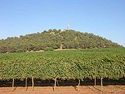
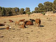
Economy
The moshav is known for growing apples, peaches and grapes. The grapes of Ramot Naftali are considered excellent by experts, and they are sold to the finest wineries in the land. The moshav has some boutique wineries, including Amram Winery of the vintner Amram Azulai. Some members of the moshav make their living by tourism or growing fowl.People
The people of Ramot Naftali are known for their contributions to the Paratroopers Brigade and to elite army units. Eitan Blahsan, a commander of Sayeret Tzanhanim, was born in Ramot Naftali, and was killed in a battle in Lebanon. Army members had high hopes for him and thought he might someday rise to Chief of Staff (RamatkalRamatkal
The Chief of the General Staff, also known as the Commander-in-Chief of the Israel Defense Forces is the supreme commander and Chief of Staff of the Israel Defense Forces. At any given time, the Chief of Staff is the only active officer holding the IDF's highest rank, Rav Aluf , which is usually...
). Mitzpe Eitan was erected as a memorial near the moshav, overlooking the Lebanon mountains and his parents' house.
Nearby places
Near Ramot Naftali are the following communities: kibbutz MalkiaMalkia
Malkia is a kibbutz in northern Israel. Located near the Lebanese border and Kiryat Shmona, it falls under the jurisdiction of Upper Galilee Regional Council. In 2006 it had a population of 329....
, Kibbutz Yiftah
Yiftah
Yiftah is a kibbutz in northern Israel. Located near the Lebanese border and Kiryat Shmona, it falls under the jurisdiction of Upper Galilee Regional Council...
, and moshav Dishon
Dishon
Dishon is a moshav in northern Israel, located along the border with Lebanon, between the towns of Kiryat Shmona and Safed. It is part of the Mevo'ot HaHermon Regional Council...
.
The community is located next to Metzudat Koach
Metzudat Koach
The Metzudat Koach Memorial commemorates 28 soldiers who died during the 1948 conquest of a strategically important fort. The fort and observation point is located in the Upper Galilee, close to the tomb of Nabi Yusha...
, a compound of the British Mandate, where 28 fighters were killed when it was captured during the War of Independence.