

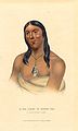
Rainy Lake and River Bands of Saulteaux
Encyclopedia
Ojibwe language
Ojibwe , also called Anishinaabemowin, is an indigenous language of the Algonquian language family. Ojibwe is characterized by a series of dialects that have local names and frequently local writing systems...
: Gojijiwininiwag) were a historical Saulteaux
Saulteaux
The Saulteaux are a First Nation in Ontario, Manitoba, Saskatchewan, Alberta and British Columbia, Canada.-Ethnic classification:The Saulteaux are a branch of the Ojibwe nations. They are sometimes also called Anihšināpē . Saulteaux is a French term meaning "people of the rapids," referring to...
(Ojibwe) group located in Northwestern Ontario
Northwestern Ontario
Northwestern Ontario is the region within the Canadian province of Ontario which lies north and west of Lake Superior, and west of Hudson Bay and James Bay. It includes most of subarctic Ontario. Its western boundary is the Canadian province of Manitoba, which disputed Ontario's claim to the...
and northern Minnesota
Minnesota
Minnesota is a U.S. state located in the Midwestern United States. The twelfth largest state of the U.S., it is the twenty-first most populous, with 5.3 million residents. Minnesota was carved out of the eastern half of the Minnesota Territory and admitted to the Union as the thirty-second state...
, along and about the Rainy Lake
Rainy Lake
Rainy Lake is a relatively large freshwater lake that straddles the border between the United States and Canada. The Rainy River issues from the west side of the lake and is harnessed to make hydroelectricity for US and Canadian locations. The U.S...
and the Rainy River.
Thorough Treaty of Paris (1783)
Treaty of Paris (1783)
The Treaty of Paris, signed on September 3, 1783, ended the American Revolutionary War between Great Britain on the one hand and the United States of America and its allies on the other. The other combatant nations, France, Spain and the Dutch Republic had separate agreements; for details of...
and the Webster-Ashburton Treaty
Webster-Ashburton Treaty
The Webster–Ashburton Treaty, signed August 9, 1842, was a treaty resolving several border issues between the United States and the British North American colonies...
(1842), the Gojijiwininiwag were split between those in the United States and those in the British North America (which later became Canada). The Gojijiwininiwag in Canada became parties to Treaty 3
Treaty 3
Treaty 3 was an agreement entered into on October 3, 1873, by the Ojibway Nation and Queen Victoria. The treaty ceded a vast tract of Ojibway territory, including large parts of what is now northwestern Ontario and a small part of eastern Manitoba, to the Government of Canada...
.
In Canada, the communities forming the Rainy Lake and River Bands of Saulteaux interacted with the Canadian government with Department of Indian Affairs (today, Indian and Northern Affairs Canada
Indian and Northern Affairs Canada
The Department of Aboriginal Affairs and Northern Development is the department of the government of Canada with responsibility for policies relating to Aboriginal peoples...
) through the Couchiching Agency, Fort Frances, Ontario
Fort Frances, Ontario
Fort Frances is a town in, and the seat of, Rainy River District in Northwestern Ontario, Canada. The population as of the 2006 census was 8,103 and Fort Frances' population peaked in 1971 at 9,947...
, from 1871-1903, after which the agency became the Fort Frances Agency. Rainy River Bands at one time had a joint Indian reserve
Indian reserve
In Canada, an Indian reserve is specified by the Indian Act as a "tract of land, the legal title to which is vested in Her Majesty, that has been set apart by Her Majesty for the use and benefit of a band." The Act also specifies that land reserved for the use and benefit of a band which is not...
known as the "Wild Land 15M." The Rainy Lake Bands still have a joint reserve known as the Agency 1
Agency 1, Ontario
Agency 1 is a First Nations reserve in the Canadian province of Ontario in the northwest. , the population is 0. The Indian Reserve is shared among four First Nations: Couchiching First Nation, Naicatchewenin First Nation, Nicickousemenecaning First Nation and Stanjikoming First Nation.-External...
.
Ethnonyms
The Rainy Lake and River Bands of Saulteaux are named after their location of Rainy Lake and Rainy River, which in the Ojibwe language are Gojiji-zaaga'igan and Gojiji-ziibi, respectively. Handbook of North American Indians record other variations of their names. The locative form of the region — gojijiing — is the basis for names of Koochiching County, MinnesotaKoochiching County, Minnesota
Koochiching County is a county located in the U.S. state of Minnesota. As of 2010, the population was 13,311. Its county seat is International Falls. A portion of the Bois Forte Indian Reservation is in the county. A small part of Voyageurs National Park extends into its northeast...
and Couchiching First Nation
Couchiching First Nation
The Couchiching First Nation is a Saulteaux First Nation in the Canadian province of Ontario, who live on the Couchiching 16A and Agency 1 reserves in the Rainy River District near Fort Frances....
.
- Algonquins of Rainy Lake — Lewis and Clark, Travels, 55, 1806.
- Ko1che1che1 Wenenewak — Long, Expedition of St. Peter's River, II, 153, 1824
- Ko-je-je-win-in-e-wug — Warren (1842) in Minnesota Hisotrical Society Collections, V, 84, 1885.
- Kotchitchi-wininiwak — Gatschet, Ojibwa MS., BAE, 1882.
- Kutcitciwininiwag — William Jones, information, 1906.
- Lac la Pluie Indians — Hind, Red River Expedition, I, 82, 1860
- Rainy Lake Indians — Schoolcraft (1838) in H.R. Doc. 107, 25th Congress, 3d. session, 9, 1839.
- Tecamamiouen — Chauvignerie (1736) in New York Document on Colonial History, IX, 1054, 1855.
Bands
Rainy Lake Bands of Saulteaux- Couchiching First NationCouchiching First NationThe Couchiching First Nation is a Saulteaux First Nation in the Canadian province of Ontario, who live on the Couchiching 16A and Agency 1 reserves in the Rainy River District near Fort Frances....
, Fort Frances, OntarioFort Frances, OntarioFort Frances is a town in, and the seat of, Rainy River District in Northwestern Ontario, Canada. The population as of the 2006 census was 8,103 and Fort Frances' population peaked in 1971 at 9,947... - Naicatchewenin First NationNaicatchewenin First NationThe Naicatchewenin First Nation, also known as the Anishinaabeg of Nagaajiwanaang and formerly known as Northwest Bay First Nation, inhabited a region in Ontario that was cited in the Northwest Angle Treaty of 1873, also known as Treaty 3. Nagaajiwanaang is located approximately northwest of Fort...
, Devlin, Ontario - Nigigoonsiminikaaning First NationNigigoonsiminikaaning First NationNigigoonsiminikaaning First Nation, formerly known as the Nicickousemenecaning First Nation and as the Red Gut First Nation, is a Saulteaux First Nation located on the banks of Rainy Lake of the Rainy River District in Northwestern Ontario, Canada...
, Fort Frances, OntarioFort Frances, OntarioFort Frances is a town in, and the seat of, Rainy River District in Northwestern Ontario, Canada. The population as of the 2006 census was 8,103 and Fort Frances' population peaked in 1971 at 9,947...
— formerly known as the Nicickousemenecaning First Nation and as the Red Gut First Nation. - Stanjikoming First Nation, Fort Frances, OntarioFort Frances, OntarioFort Frances is a town in, and the seat of, Rainy River District in Northwestern Ontario, Canada. The population as of the 2006 census was 8,103 and Fort Frances' population peaked in 1971 at 9,947...
Rainy River Bands of Saulteaux
- Lac La Croix First NationLac La Croix First NationLac La Croix First Nation is a Saulteaux First Nation located in Rainy River District in northwestern Ontario, Canada, along the Ontario-Minnesota border. It is approximately 200 km northwest of Thunder Bay, Ontario...
, Fort Frances, OntarioFort Frances, OntarioFort Frances is a town in, and the seat of, Rainy River District in Northwestern Ontario, Canada. The population as of the 2006 census was 8,103 and Fort Frances' population peaked in 1971 at 9,947...
— formed from two historical bands:- Lac La Croix Band of Rainy River Saulteaux — on Lac La Croix Indian Reserve 25D (now known as Neguagon Lake Indian Reserve 25D)
- Sturgeon Lake Band of Rainy River Saulteaux — was on Sturgeon Lake Indian Reserve 24C until the Reserve was delisted by the Ontario Provincial Park Act in 1950, took this Indian ReserveIndian reserveIn Canada, an Indian reserve is specified by the Indian Act as a "tract of land, the legal title to which is vested in Her Majesty, that has been set apart by Her Majesty for the use and benefit of a band." The Act also specifies that land reserved for the use and benefit of a band which is not...
and made it part of Quetico Provincial ParkQuetico Provincial ParkQuetico Provincial Park is a large wilderness park in Northwestern Ontario, Canada, renowned for its excellent canoeing and fishing. This park shares its southern border with Minnesota's Boundary Waters Canoe Area Wilderness, which is part of the larger Superior National Forest...
.
- Little Forks Band of Rainy River Saulteaux [United States] — the southern half of the Little Forks Band of Rainy River Saulteaux [Canada] (below), and are now part of Bois Forte Band of ChippewaBois Forte Band of ChippewaBois Forte Band of Chippewa are an Ojibwe Band located in northern Minnesota, along the border between the United States and Canada...
, Nett Lake, MinnesotaNett Lake, MinnesotaNett Lake, Minnesota is an unorganized region in Minnesota spread across part of two counties:*Nett Lake, Koochiching County, Minnesota*Nett Lake, St. Louis County, MinnesotaIt is part of the Bois Forte Indian Reservation...
. - Rainy River First Nations, Manitou Rapids, Ontario — six of the seven historical Rainy River Saulteaux bands sold their Reserves in 1914-1915 and then began the amalgamation into a single Band. The Canadian federal government made the amalgamation official in the 1960s. The seven historical Saulteaux bands forming this First Nation are:
- Hungry Hall 1 Band of Rainy River Saulteaux
- Hungry Hall 2 Band of Rainy River Saulteaux
- Little Forks Band of Rainy River Saulteaux [Canada] — northern half of the Little Forks Band of Rainy River Saulteaux [United States].
- Long Sault 1 Band of Rainy River Saulteaux
- Long Sault 2 Band of Rainy River Saulteaux
- Manitou Rapids 1 Band of Rainy River Saulteaux
- Manitou Rapids 2 Band of Rainy River Saulteaux
- Seine River First NationSeine River First NationSeine River First Nation is an Ojibwe nation located roughly 300 km west of Thunder Bay, Ontario....
, Mine Centre, Ontario
External links
- Department of Indian Affairs: Reports of Indian Agents (Sessional Papers 27, 1913).
- Treaty 3 Text at Indian and Northern Affairs CanadaIndian and Northern Affairs CanadaThe Department of Aboriginal Affairs and Northern Development is the department of the government of Canada with responsibility for policies relating to Aboriginal peoples...
website. - Place of the Long Rapids
- "New era of respect proclaimed." at TheFreeLibrary.com.