
Quintipartite Deed
Encyclopedia
Province of New Jersey
The Province of New Jersey was one of the Middle Colonies of Colonial America and became the U.S. state of New Jersey in 1776. The province had originally been settled by Europeans as part of New Netherland, but came under English rule after the surrender of Fort Amsterdam in 1664, becoming a...
, dividing it into the Province of West Jersey
West Jersey
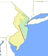
West Jersey and East Jersey were two distinct parts of the Province of New Jersey. The political division existed for 28 years, between 1674 and 1702...
and the Province of East Jersey
East Jersey
The Province of East Jersey and the Province of West Jersey were two distinct, separately governed parts of the Province of New Jersey that existed as separate provinces for 28 years, between 1674 and 1702. East Jersey's capital was located at Perth Amboy...
from 1674 until 1702.
On July 1, 1676, William Penn
William Penn
William Penn was an English real estate entrepreneur, philosopher, and founder of the Province of Pennsylvania, the English North American colony and the future Commonwealth of Pennsylvania. He was an early champion of democracy and religious freedom, notable for his good relations and successful...
, Gawen Lawrie
Gawen Lawrie
Gawen Lawrie was a governor of East Jersey from 1683 to 1686.Lawrie was one of the signers of the Quintipartite Deed that split New Jersey into West and East Jersey.-See also:* List of Governors of New Jersey...
(who served from 1683–1686 as Deputy to Governor Robert Barclay
Robert Barclay
Robert Barclay was a Scottish Quaker, one of the most eminent writers belonging to the Religious Society of Friends and a member of the Clan Barclay. He was also governor of the East Jersey colony in North America through most of the 1680s, although he himself never resided in the...
), Nicholas Lucas and Edward Byllinge executed a deed with Sir George Carteret
George Carteret
Vice Admiral Sir George Carteret, 1st Baronet , son of Elias de Carteret, was a royalist statesman in Jersey and England, who served in the Clarendon Ministry as Treasurer of the Navy...
known as the “Quintipartite Deed,” in which the territory was divided into two parts, East Jersey being taken by Carteret and West Jersey by Byllinge and his trustees.
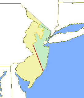
Almost as soon as the Deed was signed, disputes arose over the exact dividing point of the two provinces. The first attempt at resolving the issue, the Keith line
Keith line
The Keith line was a line drawn through the Province of New Jersey, dividing it into the Province of West Jersey and the Province of East Jersey. The line was created by Surveyor-General George Keith in 1686, when he ran the first survey to mark out the border between West Jersey and East Jersey...
, was created by Surveyor-General George Keith
George Keith
George Keith was a Scottish missionary.-Life:Born in Peterhead, Aberdeenshire, Scotland, to a Presbyterian family, he received an M.A. from the University of Aberdeen...
in 1686, and runs North-Northwest from the southern part of Little Egg Harbor Township
Little Egg Harbor Township, New Jersey
Little Egg Harbor Township is a Township in Ocean County, New Jersey, United States. As of the 2010 United States Census, the township population had increased to a record high of 20,065....
, passing just north of Tuckerton
Tuckerton, New Jersey
Tuckerton is a Borough in Ocean County, New Jersey, named for founder Ebenezer Tucker , and was a port of entry, but not the third Port of Entry as commonly believed, in the United States As of the 2000 United States Census, the borough population was 3,517.Tuckerton was incorporated as a borough...
, and reaching upward to a point on the Delaware River
Delaware River
The Delaware River is a major river on the Atlantic coast of the United States.A Dutch expedition led by Henry Hudson in 1609 first mapped the river. The river was christened the South River in the New Netherland colony that followed, in contrast to the North River, as the Hudson River was then...
which is just north of the Delaware Water Gap
Delaware Water Gap
The Delaware Water Gap is on the border of New Jersey and Pennsylvania where the Delaware River cuts through a large ridge of the Appalachian Mountains...
. More accurate surveys and maps were made to further resolve property disputes. This resulted in the Thornton line, drawn around 1696, and the Lawrence line, drawn around 1743, which was adopted as the final line for legal purposes.