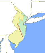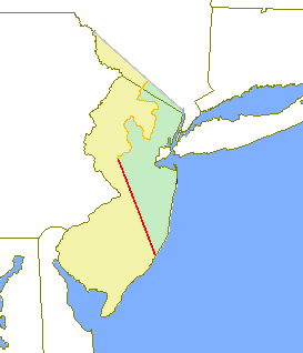
Keith line
Encyclopedia

Province of New Jersey
The Province of New Jersey was one of the Middle Colonies of Colonial America and became the U.S. state of New Jersey in 1776. The province had originally been settled by Europeans as part of New Netherland, but came under English rule after the surrender of Fort Amsterdam in 1664, becoming a...
, dividing it into the Province of West Jersey
West Jersey
West Jersey and East Jersey were two distinct parts of the Province of New Jersey. The political division existed for 28 years, between 1674 and 1702...
and the Province of East Jersey
East Jersey
The Province of East Jersey and the Province of West Jersey were two distinct, separately governed parts of the Province of New Jersey that existed as separate provinces for 28 years, between 1674 and 1702. East Jersey's capital was located at Perth Amboy...
. The line was created by Surveyor-General George Keith
George Keith
George Keith was a Scottish missionary.-Life:Born in Peterhead, Aberdeenshire, Scotland, to a Presbyterian family, he received an M.A. from the University of Aberdeen...
in 1686, when he ran the first survey to mark out the border between West Jersey and East Jersey
Border between West Jersey and East Jersey
The Province of New Jersey was formally separated into two provinces, West Jersey and East Jersey, for the 28 years between 1674 and 1702.Determination of an exact location for a West Jersey/East Jersey borderline was often a matter of dispute...
. The Keith line was intended to clarify disputes resulting from the 1676 Quintipartite Deed
Quintipartite Deed
The Quintipartite Deed was a legal document that split the Province of New Jersey, dividing it into the Province of West Jersey and the Province of East Jersey from 1674 until 1702....
, which created the two territories.
The Keith Line runs North-Northwest from the southern part of Little Egg Harbor Township
Little Egg Harbor Township, New Jersey
Little Egg Harbor Township is a Township in Ocean County, New Jersey, United States. As of the 2010 United States Census, the township population had increased to a record high of 20,065....
, passing just north of Tuckerton
Tuckerton, New Jersey
Tuckerton is a Borough in Ocean County, New Jersey, named for founder Ebenezer Tucker , and was a port of entry, but not the third Port of Entry as commonly believed, in the United States As of the 2000 United States Census, the borough population was 3,517.Tuckerton was incorporated as a borough...
. The line was to continue upward to a point on the Delaware River
Delaware River
The Delaware River is a major river on the Atlantic coast of the United States.A Dutch expedition led by Henry Hudson in 1609 first mapped the river. The river was christened the South River in the New Netherland colony that followed, in contrast to the North River, as the Hudson River was then...
which is just north of the Delaware Water Gap
Delaware Water Gap
The Delaware Water Gap is on the border of New Jersey and Pennsylvania where the Delaware River cuts through a large ridge of the Appalachian Mountains...
, but Keith was stopped in his survey by Governor of West Jersey Daniel Coxe
Daniel Coxe
Dr. Daniel Coxe was a governor of West Jersey from 1687-1688 and 1689-1692.-Biography:The Coxe family traced their lineage to a Daniel Coxe who lived in Somersetshire, England in the 13th century and obtained a doctor of medicine degree from Salerno University. Daniel Coxe's father was also called...
, when Keith had reached the South Branch
South Branch Raritan River
The South Branch Raritan River is a tributary of the Raritan River in central New Jersey in the United States.The source of the South Branch is the outflow from Budd Lake, a glacial remnant located a few miles northeast of Hackettstown...
of the Raritan River
Raritan River
The Raritan River is a major river of central New Jersey in the United States. Its watershed drains much of the mountainous area of the central part of the state, emptying into the Raritan Bay on the Atlantic Ocean.-Description:...
in what is now Three Bridges
Three Bridges, New Jersey
Three Bridges is an unincorproated community in Hunterdon County, New Jersey, United States, on the South Branch Raritan River, named for the three original bridges there which crossed the river. Farmers, John Vlerebone and Harriet Foster Cline were original land owners in the area of Three Bridges...
in Readington Township
Readington Township, New Jersey
Readington Township is a Township located in the easternmost portion of Hunterdon County, New Jersey. As of the 2010 United States Census, the township population was 16,126...
. More accurate surveys and maps were made to further resolve property disputes. This resulted in the Thornton line, drawn around 1696, and the Lawrence line, drawn around 1743, which was adopted as the final line for legal purposes.
In contemporary culture, the Keith Line has been cited as marking the approximate boundary between spheres of influence for New York City
New York City
New York is the most populous city in the United States and the center of the New York Metropolitan Area, one of the most populous metropolitan areas in the world. New York exerts a significant impact upon global commerce, finance, media, art, fashion, research, technology, education, and...
sports teams and Philadelphia sports teams; especially in the rivalry between the New York Giants
New York Giants
The New York Giants are a professional American football team based in East Rutherford, New Jersey, representing the New York City metropolitan area. The Giants are currently members of the Eastern Division of the National Football Conference in the National Football League...
and the Philadelphia Eagles
Philadelphia Eagles
The Philadelphia Eagles are a professional American football team based in Philadelphia, Pennsylvania. They are members of the East Division of the National Football Conference in the National Football League...
http://www.nydailynews.com/sports/football/giants/2009/01/10/2009-01-10_7000population_town_epicenter_of_giantse.html

