

Quiggly hole
Encyclopedia
First Nations
First Nations is a term that collectively refers to various Aboriginal peoples in Canada who are neither Inuit nor Métis. There are currently over 630 recognised First Nations governments or bands spread across Canada, roughly half of which are in the provinces of Ontario and British Columbia. The...
people of the Interior
Interior Plateau
The Interior Plateau comprises a large region of central British Columbia, and lies between the Cariboo and Monashee Mountains on the east, and the Hazelton Mountains, Coast Mountains and Cascade Range on the west. The continuation of the plateau into the United States is known there as the...
of British Columbia
British Columbia
British Columbia is the westernmost of Canada's provinces and is known for its natural beauty, as reflected in its Latin motto, Splendor sine occasu . Its name was chosen by Queen Victoria in 1858...
and the Columbia Plateau
Columbia Plateau
The Columbia Plateau is a geologic and geographic region that lies across parts of the U.S. states of Washington, Oregon, and Idaho. It is a wide flood basalt plateau between the Cascade Range and the Rocky Mountains, cut through by the Columbia River...
in the U.S.
United States
The United States of America is a federal constitutional republic comprising fifty states and a federal district...
. The word quiggly comes from kickwillie or keekwulee, the Chinook Jargon
Chinook Jargon
Chinook Jargon originated as a pidgin trade language of the Pacific Northwest, and spread during the 19th century from the lower Columbia River, first to other areas in modern Oregon and Washington, then British Columbia and as far as Alaska, sometimes taking on characteristics of a creole language...
word for "beneath" or "under".
Appearance and location
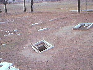
Quiggles appear as a circular depression in the ground which are the remnants of former log-roofed pithouses. Quigglies generally come in large groupings known as quiggly towns, some with hundreds of holes indicating a potential population of thousands. Some of these holes were residential for single family or larger groups, while some may have been storage only. Quiggly towns are typically located where solar exposure, water supply, and access to fish, game and gatherable foodstuffs are favourable.Quiggly towns and smaller groups of quiggly holes are common features of the landscape in certain areas of southern British Columbia
British Columbia
British Columbia is the westernmost of Canada's provinces and is known for its natural beauty, as reflected in its Latin motto, Splendor sine occasu . Its name was chosen by Queen Victoria in 1858...
, notably from the Fraser Canyon
Fraser Canyon
The Fraser Canyon is an 84 km landform of the Fraser River where it descends rapidly through narrow rock gorges in the Coast Mountains en route from the Interior Plateau of British Columbia to the Fraser Valley...
near Lillooet
Lillooet, British Columbia
Lillooet is a community on the Fraser River in western Canada, about up the British Columbia Railway line from Vancouver. Situated at an intersection of deep gorges in the lee of the Coast Mountains, it has a dry climate- of precipitation is recorded annually at the town's weather station,...
across the Thompson River
Thompson River
The Thompson River is the largest tributary of the Fraser River, flowing through the south-central portion of British Columbia, Canada. The Thompson River has two main branches called the South Thompson and the North Thompson...
valley and down the Okanagan Valley
Okanagan
The Okanagan , also known as the Okanagan Valley and sometimes as Okanagan Country is a region located in the Canadian province of British Columbia defined by the basin of Okanagan Lake and the Canadian portion of the Okanagan River. As of 2009, the region's population is approximately 350,927. The...
.
Archaeological site
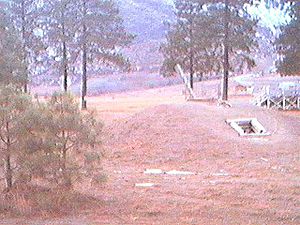
One of the quiggly towns in the Fraser CanyonFraser Canyon
The Fraser Canyon is an 84 km landform of the Fraser River where it descends rapidly through narrow rock gorges in the Coast Mountains en route from the Interior Plateau of British Columbia to the Fraser Valley...
, located at Keatley Creek between the modern-day First Nations
First Nations
First Nations is a term that collectively refers to various Aboriginal peoples in Canada who are neither Inuit nor Métis. There are currently over 630 recognised First Nations governments or bands spread across Canada, roughly half of which are in the provinces of Ontario and British Columbia. The...
communities at Fountain
Fountain, British Columbia
Fountain is an unincorporated rural area and Indian Reserve community in the Fraser Canyon region of British Columbia, Canada, located at the ten-mile mark from the town of Lillooet on BC Highway 99, which in that area is also on the route of the Old Cariboo Road and is located at the junction of...
and Pavilion
Pavilion, British Columbia
Pavilion is a ranching and Indian Reserve community in the Fraser Canyon area of British Columbia, Canada. Most of the community is the population of the Pavilion 1 Indian Reserve of the Pavilion Indian Band, aka the Ts'kw'aylaxw First Nation but there are also a number of ranches in the...
, is home of over 115 quiggly holes. It has been the subject of formal archaeological investigation. Diggings have shown its origins to have been between 4,800 BCE and 2,400 BCE, with ongoing habitation up to 1,100 BCE. The reason for the abandonment is believed to have been the collapse of a slide which had blocked the Fraser River
Fraser River
The Fraser River is the longest river within British Columbia, Canada, rising at Fraser Pass near Mount Robson in the Rocky Mountains and flowing for , into the Strait of Georgia at the city of Vancouver. It is the tenth longest river in Canada...
, forming a lake reaching upstream many miles, such that the location at Keatley Creek was near the shoreline (it is today on a benchland high above the river's canyon).
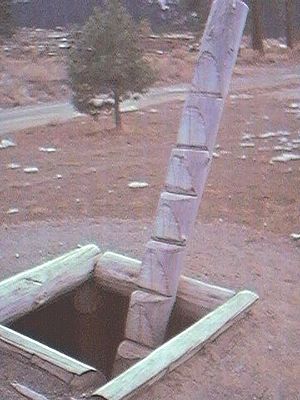
Description
This type of structure was used for storage as well as housing and cooking, and may have had its origins as an expansion of the concept of a root cellarRoot cellar
A root cellar is a structure built underground or partially underground and used to store vegetables, fruits, and nuts or other foods.-Construction:Common construction methods are:...
. In their most elaborate form, a deep pit is covered by a dome made out of a log frame, then covered by earth. Usually entrance is made either by a side hole, or a ladder via the fire hole in the top. Today the word quiggly usually only means the archaeological remains, not an active underground house, if one is being spoken of in a story or a history.
Similar structures are used in the sweat lodge
Sweat lodge
The sweat lodge is a ceremonial sauna and is an important event in some North American First Nations or Native American cultures...
s that are common in First Nations
First Nations
First Nations is a term that collectively refers to various Aboriginal peoples in Canada who are neither Inuit nor Métis. There are currently over 630 recognised First Nations governments or bands spread across Canada, roughly half of which are in the provinces of Ontario and British Columbia. The...
communities today, though those are made out of sticks instead of logs, with branches and blankets instead of earth as a covering. As with sweat lodge
Sweat lodge
The sweat lodge is a ceremonial sauna and is an important event in some North American First Nations or Native American cultures...
s, some quiggly holes were once undoubtedly used for ritual and community as well.
Range of use
Although found to a limited degree on the southern British Columbia CoastBritish Columbia Coast
The British Columbia Coast or BC Coast is Canada's western continental coastline on the Pacific Ocean. The usage is synonymous with the term West Coast of Canada....
and Puget Sound
Puget Sound
Puget Sound is a sound in the U.S. state of Washington. It is a complex estuarine system of interconnected marine waterways and basins, with one major and one minor connection to the Strait of Juan de Fuca and the Pacific Ocean — Admiralty Inlet being the major connection and...
where log-frame longhouses and lean-to structures are more common, they are the main trait of native pre-Contact archaeology throughout the Interior cultures, and may have variously been either seasonal or permanent settlements. Replacement of quigglies with modern-style housing in the Interior only began in the late 19th Century, with individual holdouts of active underground house living into the mid-20th Century. Efforts to resettle Interior Plateau
Interior Plateau
The Interior Plateau comprises a large region of central British Columbia, and lies between the Cariboo and Monashee Mountains on the east, and the Hazelton Mountains, Coast Mountains and Cascade Range on the west. The continuation of the plateau into the United States is known there as the...
First Nations
First Nations
First Nations is a term that collectively refers to various Aboriginal peoples in Canada who are neither Inuit nor Métis. There are currently over 630 recognised First Nations governments or bands spread across Canada, roughly half of which are in the provinces of Ontario and British Columbia. The...
in log-cabin villages - "modern" housing in the 19th C., relatively speaking - were launched by the Oblate Fathers as part of their missionary work.
A reconstruction
Lillooet Tribal Council
The Lillooet Tribal Council is the official English name of the largest tribal council of what is also known as the St'at'imc Nation, though not including all governments of St'at'imc peoples - the term St'at'imc Nation has another context of all St'at'imc peoples, not just those within this tribal...
's offices near the reserve community of T't'ikt (in English the "T-bird Rancherie
Rancherie
A Rancherie is a First Nations residential area of an Indian Reserve in colloquial English throughout the Canadian province of British Columbia...
") in Lillooet, British Columbia
Lillooet, British Columbia
Lillooet is a community on the Fraser River in western Canada, about up the British Columbia Railway line from Vancouver. Situated at an intersection of deep gorges in the lee of the Coast Mountains, it has a dry climate- of precipitation is recorded annually at the town's weather station,...
. Called a si7xten (SHIH-stn) in the St'at'imcets language, its design is based on notes drawn by anthropologist James Teit
James Teit
James Alexander Teit was an anthropologist and photographer who worked with Franz Boas to study Interior Salish First Nations peoples in the late 19th and early 20th centuries...
, who had settled and married in with the Nlaka'pamux
Nlaka'pamux
The Nlaka'pamux , commonly called "the Thompson", and also Thompson River Salish, Thompson Salish, Thompson River Indians or Thompson River people) are an indigenous First Nations/Native American people of the Interior Salish language group in southern British Columbia...
people of Spences Bridge
Spences Bridge, British Columbia
Spences Bridge is a community in the Canadian province of British Columbia, situated 23 miles north east of Lytton and 32 miles from Ashcroft. In 1892, the population included 32 people of European ancestry and 130 First Nations people. There were 5 general stores, 3 hotels, one Church of England...
. Teit had never been to Lillooet
Lillooet, British Columbia
Lillooet is a community on the Fraser River in western Canada, about up the British Columbia Railway line from Vancouver. Situated at an intersection of deep gorges in the lee of the Coast Mountains, it has a dry climate- of precipitation is recorded annually at the town's weather station,...
and based all his knowledge of the si7xten and the rest of his notes on that people, but based all his knowledge on interviews with a St'at'imc
St'at'imc
The St'át'imc are an Interior Salish people located in the southern Coast Mountains and Fraser Canyon region of the Interior of the Canadian province of British Columbia.St'át'imc culture displayed many features typical of Northwest Coast peoples: the...
woman who had married into the Spences Bridge people. It was not just from her account that Teit drew drawings upon which Lillooet's rebuilt si7xten was built, but also from his knowledge of underground houses in the Thompson
Thompson River
The Thompson River is the largest tributary of the Fraser River, flowing through the south-central portion of British Columbia, Canada. The Thompson River has two main branches called the South Thompson and the North Thompson...
and Bonaparte
Bonaparte River
The Bonaparte River is a tributary of the Thompson River, joining it at the community of Ashcroft, British Columbia. The river is about long, including the length of Bonaparte Lake...
valleys - in his day, many people still lived in them. The reconstruction proceeded with his designs, with the caveat that the si7xten as built may not exactly resemble those used by the St'at'imc
St'at'imc
The St'át'imc are an Interior Salish people located in the southern Coast Mountains and Fraser Canyon region of the Interior of the Canadian province of British Columbia.St'át'imc culture displayed many features typical of Northwest Coast peoples: the...
, as those with the knowledge of how they were built died years before there was interest in restoring one.
First Nations
First Nations is a term that collectively refers to various Aboriginal peoples in Canada who are neither Inuit nor Métis. There are currently over 630 recognised First Nations governments or bands spread across Canada, roughly half of which are in the provinces of Ontario and British Columbia. The...
land claims
Land claims
Land claims are a legal declaration of desired control over areas of property including bodies of water. The phrase is usually only used with respect to disputed or unresolved land claims...
, where they are more than symbols of native occupancy - they are the proof of ownership, as well as a priori occupation rights including sovereignty
Sovereignty
Sovereignty is the quality of having supreme, independent authority over a geographic area, such as a territory. It can be found in a power to rule and make law that rests on a political fact for which no purely legal explanation can be provided...
. Inventories of quigglies and other archaoloegical remains are important parts of the land claims
Land claims
Land claims are a legal declaration of desired control over areas of property including bodies of water. The phrase is usually only used with respect to disputed or unresolved land claims...
process and archaeological protection acts may be invoked to preserve and study them. Quigglies on private land, however, are not protected, although some of these wind up being studied at the invitation of the owner.
Although many quiggly towns are relatively new, up to a few hundred years, many more are very ancient, as at Keatley Creek, but also throughout the Interior. And in addition to the Plateau cultures, there is an isolated appearance of quiggly-type structures on the Oregon Coast
Oregon Coast
The Oregon Coast is a region of the U.S. state of Oregon. It runs generally north-south along the Pacific Ocean, forming the western border of the state; the region is bounded to the east by the Oregon Coast Range. The Oregon Coast stretches approximately from the Columbia River in the north to...
, in what is otherwise exclusively log-frame/housepost housing area. Its occupants are believed by archaeologists to have been ancestors of the Athapaskan-people resident in the area now, who had originally used their familiar style of housing when they first migrated into the region.