

Queanbeyan River
Encyclopedia
The Queanbeyan River is a tributary of the Molonglo River
and part of Murray-Darling Basin
. The river is 70 kilometres in length and the river catchment is 96,000 hectares in size. The Queanbeyan River is one of two rivers—the Cotter River
is the other—that meet the water supply
needs of the Canberra and Queanbeyan
region and whose water quality is specifically protected under Federal legislation.
and about 40 kilometres northeast of the township of Bredbo, near the village of Jerangle. Several creeks upstream of the Googong Dam contribute to the river flow including the Burra, Urialla, Tinderry, Ballinafad, Groggy, Woolpack, Sherlock, Lyons, Towneys and Mile Creeks. The major river crossings above Googong Dam are the Boolboolma causeway on the Tinderry Road and a road bridge on the Captain's Flat-Jerangle Road.
Once inside the town precinct of Queanbeyan
, the river is crossed by several bridges, including the Canberra-Goulburn railway, Morisset street bridge, the Queens Bridge on Monaro Street (which becomes Bungendore Road or Kings Highway), and by a pedestrian footbridge near Isabella Street in East Queanbeyan. Queens Bridge, which as a plaque on the bridge states, was opened by Wal Fife, MLA, Minister for transport and highways on the 21 July 1975. The Queanbeyan River meets the Molonglo River
at a confluence located in Oaks Estate
, within the boundary of the Australian Capital Territory
.
.
The Queanbeyan River was the main water supply for the towns of Queanbeyan and during its early history its was an integral element to its economy. Wool scouring (cleaning) was carried out in the river near presentday Oaks Estate, formerly a part of Queanbeyan.
With a river catchment area of 920 square kilometres, the Queanbeyan River's is more than double that of the Cotter River
. Prior to the construction to the Googong Dam, the river was floodprone leading to significant loss of life. During the 1976 flood the half completed Googong Dam was at risk of collapse under the weight of water behind it. In this eventuality low lying parts of Queanbeyan and Canberra would have been inundated. The Queanbeyan Cemetery was flooded, with scores of bodies washed downstream into Lake Burley Griffin
.
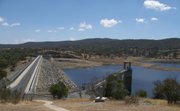 The Googong Dam is located five kilometres upstream of the town of Queanbeyan. The dam was completed in 1979 and has a maximum carrying capacity of 124,500 million litres.. The Commonwealth Government owns the dam which is operated by ACTEWAGL, the ACT's electricity, water and gas utility provider. The ACT Government manages the dam foreshores. Lower flows in the river downstream of the dam since its construction, together with below average rainfall for the past decade, have modified the river channel and led to an increase in colonisation by willow
s and river plants which enjoy low flows. Management of the river includes eradication of these weeds.
, which once extended to the vicinity of Googong Dam, and native Macquarie perch
, which extended to at least the headwaters of Googong Dam. Due to this abundance of native fish, the Queanbeyan River, along with the Molonglo River, was often known as the "Fish River" in the early days of settlement. Sometimes the Queanbeyan was further distinguished by being called the "South Fish River". On more than one occasion in the late 19th and early 20th centuries floods deposited live Murray Cod in the main streets of Queanbeyan. Sadly, this abundance of native fish did not last. A variety of ills including introduction of exotic fish such as trout
, overfishing, willow encroachment, siltation, and weirs blocking migration saw native fish populations in the Queanbeyan River close to extinction by the time Googong Dam was built.
access to resources including water by protecting and not polluting the waters of the Queanbeyan River.
The condition of the river as a native habitat below Googong Dam has been seen as unhealthy in recent years by the council, with the river being over-run with carp
and reeds. The council has put in place a resource development scheme to clean out the river, including a 'catch a carp' competition where the winners won $500 or fishing gear.
European carp have not penetrated the river above Googong Dam, providing an excellent trout and native fish catchery in both the dam and the river upstream. Koi
carp are present the entire length of the river, but in small quantities. Since construction of Googong Dam in 1979, the endangered two-spined blackfish
and Macquarie perch
have been very occasionally reported in the river, and rarely beyond the first waterfall upstream of Googong Dam, despite the introduction of 57 Macquarie perch in the 1980s.
Molonglo River
The Molonglo River rises on the western side of the Great Dividing Range of eastern Australia in the state of New South Wales. Its source is on the other side of the mountain range from where the Shoalhaven River rises, in Tallaganda state forest at ~1200 metres altitude...
and part of Murray-Darling Basin
Murray-Darling Basin
The Murray-Darling basin is a large geographical area in the interior of southeastern Australia, whose name is derived from its two major rivers, the Murray River and the Darling River. It drains one-seventh of the Australian land mass, and is currently by far the most significant agricultural...
. The river is 70 kilometres in length and the river catchment is 96,000 hectares in size. The Queanbeyan River is one of two rivers—the Cotter River
Cotter River
The Cotter River is a fresh water river in the Australian Capital Territory. It is a tributary of the Murrumbidgee River and part of Murray-Darling Basin. The Cotter River is one of two rivers—the Queanbeyan River is the other—that meet the water supply needs of the Canberra and...
is the other—that meet the water supply
Water supply
Water supply is the provision of water by public utilities, commercial organisations, community endeavours or by individuals, usually via a system of pumps and pipes...
needs of the Canberra and Queanbeyan
Queanbeyan, New South Wales
Queanbeyan is a regional centre in the Southern Tablelands in south-eastern New South Wales adjacent to the Australian Capital Territory. The city's mixed economy is based on light construction, high technology, manufacturing, service, retail and agriculture. It is the council seat of the...
region and whose water quality is specifically protected under Federal legislation.
River course
The headwaters of the Queanbeyan River rise 70 kilometres east-southeast of QueanbeyanQueanbeyan, New South Wales
Queanbeyan is a regional centre in the Southern Tablelands in south-eastern New South Wales adjacent to the Australian Capital Territory. The city's mixed economy is based on light construction, high technology, manufacturing, service, retail and agriculture. It is the council seat of the...
and about 40 kilometres northeast of the township of Bredbo, near the village of Jerangle. Several creeks upstream of the Googong Dam contribute to the river flow including the Burra, Urialla, Tinderry, Ballinafad, Groggy, Woolpack, Sherlock, Lyons, Towneys and Mile Creeks. The major river crossings above Googong Dam are the Boolboolma causeway on the Tinderry Road and a road bridge on the Captain's Flat-Jerangle Road.
Once inside the town precinct of Queanbeyan
Queanbeyan, New South Wales
Queanbeyan is a regional centre in the Southern Tablelands in south-eastern New South Wales adjacent to the Australian Capital Territory. The city's mixed economy is based on light construction, high technology, manufacturing, service, retail and agriculture. It is the council seat of the...
, the river is crossed by several bridges, including the Canberra-Goulburn railway, Morisset street bridge, the Queens Bridge on Monaro Street (which becomes Bungendore Road or Kings Highway), and by a pedestrian footbridge near Isabella Street in East Queanbeyan. Queens Bridge, which as a plaque on the bridge states, was opened by Wal Fife, MLA, Minister for transport and highways on the 21 July 1975. The Queanbeyan River meets the Molonglo River
Molonglo River
The Molonglo River rises on the western side of the Great Dividing Range of eastern Australia in the state of New South Wales. Its source is on the other side of the mountain range from where the Shoalhaven River rises, in Tallaganda state forest at ~1200 metres altitude...
at a confluence located in Oaks Estate
Oaks Estate, Australian Capital Territory
Oaks Estate is an urban village situated immediately on the northern side of the NSW-ACT border abutting the township of Queanbeyan in south-eastern New South Wales, Australia. The estate covers an area of approximately 40 hectares and is bound by the Molonglo River to the north, 'The Oaks' to the...
, within the boundary of the Australian Capital Territory
Australian Capital Territory
The Australian Capital Territory, often abbreviated ACT, is the capital territory of the Commonwealth of Australia and is the smallest self-governing internal territory...
.
History
The Queanbeyan region is the traditional home of the Ngunnawal People. The first Europeans visitors to the area were led by Charles Throsby. While searching for the Murrumbidgee River in 1820, his party followed the course of the Queanbeyan River into a valley at the eastern end of the Limestone Plains near presentday CanberraCanberra
Canberra is the capital city of Australia. With a population of over 345,000, it is Australia's largest inland city and the eighth-largest city overall. The city is located at the northern end of the Australian Capital Territory , south-west of Sydney, and north-east of Melbourne...
.
The Queanbeyan River was the main water supply for the towns of Queanbeyan and during its early history its was an integral element to its economy. Wool scouring (cleaning) was carried out in the river near presentday Oaks Estate, formerly a part of Queanbeyan.
With a river catchment area of 920 square kilometres, the Queanbeyan River's is more than double that of the Cotter River
Cotter River
The Cotter River is a fresh water river in the Australian Capital Territory. It is a tributary of the Murrumbidgee River and part of Murray-Darling Basin. The Cotter River is one of two rivers—the Queanbeyan River is the other—that meet the water supply needs of the Canberra and...
. Prior to the construction to the Googong Dam, the river was floodprone leading to significant loss of life. During the 1976 flood the half completed Googong Dam was at risk of collapse under the weight of water behind it. In this eventuality low lying parts of Queanbeyan and Canberra would have been inundated. The Queanbeyan Cemetery was flooded, with scores of bodies washed downstream into Lake Burley Griffin
Lake Burley Griffin
Lake Burley Griffin is an artificial lake in the centre of Canberra, the capital of Australia. It was completed in 1963 after the Molonglo River—which ran between the city centre and Parliamentary Triangle—was dammed...
.
Damming
The Queanbeyan Weir was constructed originally in 1901-2 which provided a pool in the Queanbeyan River near the centre of the town for the town's water supply. It is now a place for town beautification with several parks located along the river, such as Blundell Park, Queen Elizabeth Park, and Ray Morton Park. The weir also provides for minor irrigation requirements. A buttressed concrete gravity wall which was 58 metres long, raised an extra one metre to the height of 4 metres in 1951-1952. The weir has had serious impacts on native fish migration in the Queanbeyan river.Willow
Willows, sallows, and osiers form the genus Salix, around 400 species of deciduous trees and shrubs, found primarily on moist soils in cold and temperate regions of the Northern Hemisphere...
s and river plants which enjoy low flows. Management of the river includes eradication of these weeds.
Fishing
The Queanbeyan River was renowned as a beautiful river abounding in native Murray CodMurray Cod
The Murray cod is a large Australian predatory freshwater fish of the Maccullochella genus and the Percichthyidae family. Although the species is a called cod in the vernacular, it is not related to the northern hemisphere marine cod species...
, which once extended to the vicinity of Googong Dam, and native Macquarie perch
Macquarie perch
The Macquarie perch is an Australian native freshwater fish of the Murray-Darling river system. It is a member of the Percichthyidae family and is closely related to the golden perch ....
, which extended to at least the headwaters of Googong Dam. Due to this abundance of native fish, the Queanbeyan River, along with the Molonglo River, was often known as the "Fish River" in the early days of settlement. Sometimes the Queanbeyan was further distinguished by being called the "South Fish River". On more than one occasion in the late 19th and early 20th centuries floods deposited live Murray Cod in the main streets of Queanbeyan. Sadly, this abundance of native fish did not last. A variety of ills including introduction of exotic fish such as trout
Trout
Trout is the name for a number of species of freshwater and saltwater fish belonging to the Salmoninae subfamily of the family Salmonidae. Salmon belong to the same family as trout. Most salmon species spend almost all their lives in salt water...
, overfishing, willow encroachment, siltation, and weirs blocking migration saw native fish populations in the Queanbeyan River close to extinction by the time Googong Dam was built.
Water quality
Under the Seat of Government Acceptance Act 1909 New South Wales guaranteed the Australian Capital TerritoryAustralian Capital Territory
The Australian Capital Territory, often abbreviated ACT, is the capital territory of the Commonwealth of Australia and is the smallest self-governing internal territory...
access to resources including water by protecting and not polluting the waters of the Queanbeyan River.
The condition of the river as a native habitat below Googong Dam has been seen as unhealthy in recent years by the council, with the river being over-run with carp
Carp
Carp are various species of oily freshwater fish of the family Cyprinidae, a very large group of fish native to Europe and Asia. The cypriniformes are traditionally grouped with the Characiformes, Siluriformes and Gymnotiformes to create the superorder Ostariophysi, since these groups have certain...
and reeds. The council has put in place a resource development scheme to clean out the river, including a 'catch a carp' competition where the winners won $500 or fishing gear.
European carp have not penetrated the river above Googong Dam, providing an excellent trout and native fish catchery in both the dam and the river upstream. Koi
Koi
or more specifically , are ornamental varieties of domesticated common carp that are kept for decorative purposes in outdoor koi ponds or water gardens....
carp are present the entire length of the river, but in small quantities. Since construction of Googong Dam in 1979, the endangered two-spined blackfish
Two-spined blackfish
The two-spined blackfish, Gadopsis bispinosus, is an Australian native freshwater fish. It is a speciated, more specialised upland variant of the river blackfish, Gadopsis marmoratus....
and Macquarie perch
Macquarie perch
The Macquarie perch is an Australian native freshwater fish of the Murray-Darling river system. It is a member of the Percichthyidae family and is closely related to the golden perch ....
have been very occasionally reported in the river, and rarely beyond the first waterfall upstream of Googong Dam, despite the introduction of 57 Macquarie perch in the 1980s.