
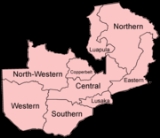
Provinces of Zambia
Encyclopedia
Zambia
is divided into 10 province
s.
Zambia
Zambia , officially the Republic of Zambia, is a landlocked country in Southern Africa. The neighbouring countries are the Democratic Republic of the Congo to the north, Tanzania to the north-east, Malawi to the east, Mozambique, Zimbabwe, Botswana and Namibia to the south, and Angola to the west....
is divided into 10 province
Province
A province is a territorial unit, almost always an administrative division, within a country or state.-Etymology:The English word "province" is attested since about 1330 and derives from the 13th-century Old French "province," which itself comes from the Latin word "provincia," which referred to...
s.
| Province | Capital | Area (km²) | Population | Density (people/km²) |
Districts |
|---|---|---|---|---|---|
| Central Central Province, Zambia Central Province is one of Zambia's nine provinces. The provincial capital is Kabwe, home of the Mulungushi Rock of Authority, founder home of UNIP, the ruling political party in the second republic .... |
Kabwe Kabwe Kabwe is the capital of the Zambian Central Province with a population estimated at 210,000. Formerly named Broken Hill, it was founded when the Broken Hill lead and zinc deposits were discovered in 1902. Kabwe also has a claim to being the birthplace of Zambian politics... |
94,395 | 1,012,257 | 10.7 | 6 |
| Copperbelt Copperbelt Province Copperbelt Province in Zambia covers the mineral-rich Copperbelt, and farming and bush areas to the south. It was the backbone of the Northern Rhodesian economy during British colonial rule and fuelled the hopes of the immediate post-independence period, but its economic importance was severely... |
Ndola Ndola Ndola is the third largest city in Zambia, with a population of 495,000 . It is the industrial, commercial, on the Copperbelt, Zambia's copper-mining region, and capital of Copperbelt Province. It is also the commercial capital city of Zambia and has one of the three international airports, others... |
31,328 | 1,581,221 | 50.5 | 10 |
| Eastern Eastern Province, Zambia Eastern Province is one of Zambia's nine provinces. The province lies between the Luangwa River and the border with Malawi, from Isoka in the northeast to just north of Luangwa in the south.The provincial capital is Chipata... |
Chipata Chipata Chipata, population 98,416, is the capital of the Eastern Province of Zambia. The two languages spoken are Nyanja and English, though you might find some Indian languages, as there is a large number of Zambian Indians located in the town... |
69,106 | 1,306,173 | 18.9 | 8 |
| Luapula Luapula Province Luapula Province is one of Zambia's nine provinces, and is located in the north of the country. The provincial capital is Mansa. Luapula Province was named after the Luapula River.... |
Mansa Mansa, Zambia Mansa is the capital of the Luapula Province of Zambia, and headquarters of Mansa District. It takes its name from the local Chief Mansa and the small Mansa River which flows west to the Luapula River... |
50,567 | 775,353 | 15.3 | 7 |
| Lusaka Lusaka Province Lusaka Province is one of Zambia's nine provinces. The provincial capital is Lusaka, which is also the national capital.-National Parks and wildlife areas:*Lower Zambezi National Park... |
Lusaka Lusaka Lusaka is the capital and largest city of Zambia. It is located in the southern part of the central plateau, at an elevation of about 1,300 metres . It has a population of about 1.7 million . It is a commercial centre as well as the centre of government, and the four main highways of Zambia head... |
21,898 | 1,391,329 | 63.5 | 4 |
| Northern Northern Province, Zambia Northern Province is one of Zambia's nine provinces. It covers approximately one fifth of Zambia in land area. The provincial capital is Kasama. The province is made up of 12 districts, namely Kasama , Chilubi, Isoka, Chinsali, Kaputa, Luwingu, Mbala, Mporokoso, Mpika, Mpulungu, Mungwi and Nakonde... |
Kasama Kasama, Zambia Kasama is the capital of the Northern Province of Zambia, situated on the central-southern African plateau at an elevation of about 1400 m. Its population, according to the 2000 census, is approximately 200,000. It grew considerably in the 1970s and 1980s after construction of the TAZARA Railway... |
147,826 | 1,258,696 | 8.5 | 7 |
| North-Western North-Western Province, Zambia North-Western Province is one of Zambia's nine provinces. It covers an area of 125,826 km² and has a population of 583,350 . It is the most sparsely populated province in the country... |
Solwezi | 125,827 | 583,350 | 4.6 | 12 |
| Southern Southern Province, Zambia Southern Province is one of Zambia's nine provinces, and home to Zambia's premier tourist attraction, Mosi-oa-Tunya , shared with Zimbabwe... |
Livingstone Livingstone, Zambia Livingstone or Maramba is a historic colonial city and present capital of the Southern Province of Zambia, a tourism centre for the Victoria Falls lying north of the Zambezi River, and a border town with road and rail connections to Zimbabwe on the other side of the Falls... |
85,283 | 1,212,124 | 14.2 | 11 |
| Western Western Province, Zambia Western Province, encompasses the area formerly known as Barotseland in the colonial era.-Districts:Western Province is divided into 7 districts:*Kalabo District*Kaoma District*Lukulu District*Mongu District*Senanga District*Sesheke District... |
Mongu Mongu Mongu is the capital of Western Province in Zambia and was the capital of the formerly-named province and historic state, Barotseland. Its population is 44,310 , and it is also headquarters of Mongu District.-Geography:... |
126,386 | 765,088 | 6.1 | 7 |
| Zambia | Lusaka | 752,616 | 9,885,591 | 13.1 | 72 |