

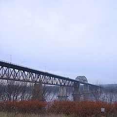
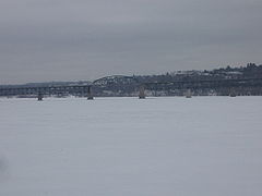
Princess Margaret Bridge
Encyclopedia
Fredericton, New Brunswick
Fredericton is the capital of the Canadian province of New Brunswick, by virtue of the provincial parliament which sits there. An important cultural, artistic, and educational centre for the province, Fredericton is home to two universities and cultural institutions such as the Beaverbrook Art...
, New Brunswick
New Brunswick
New Brunswick is one of Canada's three Maritime provinces and is the only province in the federation that is constitutionally bilingual . The provincial capital is Fredericton and Saint John is the most populous city. Greater Moncton is the largest Census Metropolitan Area...
, Canada
Canada
Canada is a North American country consisting of ten provinces and three territories. Located in the northern part of the continent, it extends from the Atlantic Ocean in the east to the Pacific Ocean in the west, and northward into the Arctic Ocean...
. It is named after HM Queen Elizabeth II
Elizabeth II of the United Kingdom
Elizabeth II is the constitutional monarch of 16 sovereign states known as the Commonwealth realms: the United Kingdom, Canada, Australia, New Zealand, Jamaica, Barbados, the Bahamas, Grenada, Papua New Guinea, the Solomon Islands, Tuvalu, Saint Lucia, Saint Vincent and the Grenadines, Belize,...
's sister HRH The Princess Margaret, Countess of Snowdon
Princess Margaret, Countess of Snowdon
Princess Margaret, Countess of Snowdon was the younger sister of Queen Elizabeth II and the younger daughter of King George VI....
.
Constructed as a steel truss structure, the bridge measures 1075 m (3,526.9 ft) in length and has a navigation clearance of 25.6 m (84 ft) in the centre. It opened in 1959 as part of the Route 2
New Brunswick Route 2
Route 2 is a major provincial highway in the Canadian province of New Brunswick, carrying the main route of the Trans-Canada Highway in the province...
Trans-Canada Highway
Trans-Canada Highway
The Trans-Canada Highway is a federal-provincial highway system that joins the ten provinces of Canada. It is, along with the Trans-Siberian Highway and Australia's Highway 1, one of the world's longest national highways, with the main route spanning 8,030 km...
bypass project around Fredericton. Following a realignment of Route 2 in 2002, the bridge now carries Route 8
New Brunswick Route 8
Route 8 is an important highway link between northern and southern New Brunswick, Canada. 255 kilometres long, it runs from Fredericton to Bathurst via Miramichi.-Route description:...
, the primary Fredericton-Miramichi
Miramichi, New Brunswick
Miramichi is the largest city in northern New Brunswick, Canada. It is situated at the mouth of the Miramichi River where it enters Miramichi Bay...
highway.
The northern approach follows the old Trans-Canada Highway alignment toward Barker's Point (now designated Route 105), but travellers wanting to continue on Route 8 must exit on a ramp immediately after leaving the bridge, while maintaining another sharp turning radius to pass back under the roadway and follow the Route 8 alignment to Marysville. This interchange is envisioned to be replaced by a straightened alignment of Route 8 onto the Marysville Bypass with a newly designed interchange with Route 105.
Starting in the summer of 2010 and continuing through the summer of 2011 from May 8th, the bridge was closed for extensive repairs to the decking, concrete piers and the steel structure. The province of New Brunswick is investing $80 million for the repairs, which when complete will extend its life for another 50 years.
Controversy
Safety concerns have precipitated many construction projects on the bridge in the 1980s and 1990s, due in part to the narrow width of the roadway and to high traffic volume. The bridge deck is prone to severe icing conditions in winter, leading to motor vehicle accidents. The bridge's narrow, two-lane span poses a hazard for motorists travelling at speeds over the posted speed limit of 70 km/h (45 mph).The approaches to the bridge on both sides are also of concern:
The southern approach descends a steep grade while transiting from a 4-lane divided freeway to 2-lane suburban/rural arterial road. Pedestrians from a St. Thomas University
St. Thomas University (New Brunswick)
St. Thomas University is jointly a public and Roman Catholic liberal arts university located in Fredericton, New Brunswick, Canada. It offers degrees exclusively at the undergraduate level for approximately 3,000 students in the liberal arts, humanities, journalism, education, and social work....
residence on the east side of the bridge frequently take a shortcut at grade across the highway up the hill from the bridge to follow the contour of the hill while en-route to the university's main campus. The southern approach also contains a modified clover leaf interchange with Forest Hill Road with very tight turning radius
Turning radius
The turning radius or turning circle of a vehicle is the size of the smallest circular turn that the vehicle is capable of making. The term turning radius is actually a misnomer, since the size of a circle is actually its diameter, not its radius. The less ambiguous term turning circle is preferred...
on exit and entrance ramps. Northbound travellers must negotiate a sharp incline and a 30-degree turning radius to access the bridge. On three occasions, tractor trailers have failed to negotiate the turn, instead crashing through the guard rail
Guard rail
Guard rail or guardrail, sometimes referred to as guide rail or railing, is a system designed to keep people or vehicles from straying into dangerous or off-limits areas...
and either dangling over the edge or falling into the river entirely.
In early May 2009, concerns were raised after a 10-kilogram chunk of concrete fell from the bridge onto the roadway underneath, narrowly missing a passing motorist's vehicle.