

Prince of Wales-Outer Ketchikan Census Area, Alaska
Encyclopedia
U.S. state
A U.S. state is any one of the 50 federated states of the United States of America that share sovereignty with the federal government. Because of this shared sovereignty, an American is a citizen both of the federal entity and of his or her state of domicile. Four states use the official title of...
of Alaska
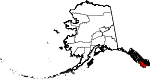
Alaska
Alaska is the largest state in the United States by area. It is situated in the northwest extremity of the North American continent, with Canada to the east, the Arctic Ocean to the north, and the Pacific Ocean to the west and south, with Russia further west across the Bering Strait...
. It is part of the unorganized borough
Unorganized Borough
The Unorganized Borough is the part of the U.S. state of Alaska not contained in any of its 18 organized boroughs. It encompasses more than half of Alaska's area, , an area larger than any other US state...
and therefore has no borough seat. Its largest communities are Craig
Craig, Alaska
Craig is a first-class city in the Prince of Wales-Hyder Census Area in the Unorganized Borough in the U.S. state of Alaska. The population was 1,397 at the 2000 census.-Geography:...
and Metlakatla
Metlakatla, Alaska
Metlakatla is a census-designated place on Annette Island in Prince of Wales-Hyder Census Area, Alaska, United States. At the 2000 census the population was 1,375.- History :...
. It was formerly part of the Census Bureau's Prince of Wales-Outer Ketchikan Census Area, but the name was changed in 2008 after most of the Outer Ketchikan (except the parts near the community of Hyder
Hyder, Alaska
Hyder is a census-designated place in Prince of Wales-Hyder Census Area, Alaska, United States. At the 2000 census the population was 97. Hyder has achieved fame as a point in Alaska accessible to automobile and motorbike travelers in Canada who want to say that they have been to Alaska...
, and Annette Island
Annette Island
Annette Island, or Taak'w Aan, is an island in Gravina Islands of the Alexander Archipelago of the Pacific Ocean on the southeastern coast of the U.S. state of Alaska. It is at . It is about long and about wide. The land area is...
) was lost to annexation by the Ketchikan Gateway Borough
Ketchikan Gateway Borough, Alaska
As of the census of 2000, there were 14,070 people, 5,399 households, and 3,633 families residing in the borough. The population density was 11 people per square mile . There were 6,218 housing units at an average density of 5 per square mile...
. As of the 2000 census, the population of the then-Prince of Wales-Outer Ketchikan Census Area was 6,146.
Geography
The pre-2008 census area had a total area of 12,706 square miles (32,909 km²), of which 7,411 square miles (19,193 km²) was land and 5,296 square miles (13,716 km², or 41.68%) was water. The present-day Prince of Wales-Hyder Census Area includes the Hyder area as an exclave, and Annette Island, which is mostly surrounded by territory of Ketchikan Gateway Borough. Before the transfer of territory, Ketchikan Gateway BoroughKetchikan Gateway Borough, Alaska
As of the census of 2000, there were 14,070 people, 5,399 households, and 3,633 families residing in the borough. The population density was 11 people per square mile . There were 6,218 housing units at an average density of 5 per square mile...
was enclaved within (surrounded by) the census area.
Adjacent boroughs and census areas
- Petersburg Census Area - north
- City and Borough of Wrangell, AlaskaWrangell, AlaskaWrangell is a city and borough in the U.S. state of Alaska. At the 2000 census the population was 2,308.Its Tlingit name is Ḵaachx̱aana.áakʼw . The Tlingit people residing in the Wrangell area, who were there centuries before Europeans, call themselves the Shtaxʼhéen Ḵwáan after the nearby Stikine...
- northeast - Ketchikan Gateway BoroughKetchikan Gateway Borough, AlaskaAs of the census of 2000, there were 14,070 people, 5,399 households, and 3,633 families residing in the borough. The population density was 11 people per square mile . There were 6,218 housing units at an average density of 5 per square mile...
- between Prince of Wales and Hyder
Also shares border with British Columbia
British Columbia
British Columbia is the westernmost of Canada's provinces and is known for its natural beauty, as reflected in its Latin motto, Splendor sine occasu . Its name was chosen by Queen Victoria in 1858...
, Canada
Canada
Canada is a North American country consisting of ten provinces and three territories. Located in the northern part of the continent, it extends from the Atlantic Ocean in the east to the Pacific Ocean in the west, and northward into the Arctic Ocean...
.
- Kitimat-Stikine Regional District, British Columbia - east
- Skeena-Queen Charlotte Regional District, British ColumbiaSkeena-Queen Charlotte Regional District, British ColumbiaThe Skeena-Queen Charlotte Regional District is a quasi-municipal administrative area in British Columbia. It is located on British Columbia's west coast and includes Haida Gwaii , the largest of which are Graham Island and Moresby Island...
- south (water boundary only, across Dixon EntranceDixon EntranceThe Dixon Entrance is a strait about long and wide in the Pacific Ocean at the International Boundary between the U.S. state of Alaska and the province of British Columbia in Canada. It was named by Joseph Banks for Captain George Dixon, a Royal Navy officer, fur trader, and explorer, who...
to Hecate StraitHecate StraitHecate Strait is a wide but shallow strait between the Haida Gwaii and the mainland of British Columbia, Canada. It merges with Queen Charlotte Sound to the south and Dixon Entrance to the north...
)
National protected areas
- Alaska Maritime National Wildlife RefugeAlaska Maritime National Wildlife RefugeThe Alaska Maritime National Wildlife Refuge is a United States National Wildlife Refuge comprising 2,400 islands, headlands, rocks, islets, spires and reefs in Alaska, with a total area of , of which is wilderness)...
(part of Gulf of Alaska unit)- Forrester Island WildernessForrester Island WildernessForrester Island Wilderness is a wilderness area in the U.S. state of Alaska at Forrester Island . It was designated by the United States Congress in 1970...
- Forrester Island Wilderness
- Tongass National ForestTongass National ForestThe Tongass National Forest in southeastern Alaska is the largest national forest in the United States at 17 million acres . Most of its area is part of the temperate rain forest WWF ecoregion, itself part of the larger Pacific temperate rain forest WWF ecoregion, and is remote enough to be home...
(part)- Karta River WildernessKarta River WildernessKarta River Wilderness is a U. S. wilderness area, centrally located on Prince of Wales Island. It is north of Hollis, Alaska just east of the Kasaan Peninsula and may be accessed by a quick 10 minute plane ride or 30-minute boat ride....
- Maurille Islands Wilderness
- South Prince of Wales Wilderness
- Warren Island Wilderness
- Karta River Wilderness
Demographics
As of the censusCensus
A census is the procedure of systematically acquiring and recording information about the members of a given population. It is a regularly occurring and official count of a particular population. The term is used mostly in connection with national population and housing censuses; other common...
of 2000, there were 6,146 people, 2,262 households, and 1,535 families residing in the then-census area. The population density
Population density
Population density is a measurement of population per unit area or unit volume. It is frequently applied to living organisms, and particularly to humans...
was 1 people per square mile (0/km²). There were 3,055 housing units at an average density of 0 persons/km² (0 persons/sq mi). The racial makeup of the census area was 53.12% White, 0.15% African American, 38.68% Native American, 0.36% Asian, 0.05% Pacific Islander, 0.50% from other races, and 7.14% from two or more races. Hispanic or Latino of any race were 1.74% of any race.
There were 2,262 households out of which 37.60% had children under the age of 18 living with them, 50.80% were married couples
Marriage
Marriage is a social union or legal contract between people that creates kinship. It is an institution in which interpersonal relationships, usually intimate and sexual, are acknowledged in a variety of ways, depending on the culture or subculture in which it is found...
living together, 10.00% have a woman whose husband does not live with her, and 32.10% were non-families. 26.00% of all households were made up of individuals and 5.00% had someone living alone who was 65 years of age or older. The average household size was 2.68 and the average family size was 3.25.
In the census area the population was spread out with 31.00% under the age of 18, 7.50% from 18 to 24, 30.10% from 25 to 44, 25.80% from 45 to 64, and 5.70% who were 65 years of age or older. The median age was 35 years. For every 100 females there were 119.80 males. For every 100 females age 18 and over, there were 125.60 males.
Cities and towns
- Coffman CoveCoffman Cove, AlaskaCoffman Cove is a city in Prince of Wales-Hyder Census Area, Alaska, in the United States. It is located on Prince of Wales Island. The population was 199 at the 2000 census.-Geography:Coffman Cove is located at ....
- CraigCraig, AlaskaCraig is a first-class city in the Prince of Wales-Hyder Census Area in the Unorganized Borough in the U.S. state of Alaska. The population was 1,397 at the 2000 census.-Geography:...
- Edna BayEdna Bay, AlaskaEdna Bay is a census-designated place on Kosciusko Island in Prince of Wales-Hyder Census Area, Alaska, United States. The population was 49 at the 2000 census....
- HollisHollis, AlaskaHollis is a census-designated place in Prince of Wales-Hyder Census Area, Alaska, United States. At the 2000 census the population was 139.-Geography:Hollis is located at ....
- HydaburgHydaburg, AlaskaHydaburg is a town in the Prince of Wales-Hyder Census Area, in the U.S. state of Alaska. The population was 382 at the 2000 census.-Geography:Hydaburg is located at . It is the southernmost city on Prince of Wales Island...
- HyderHyder, AlaskaHyder is a census-designated place in Prince of Wales-Hyder Census Area, Alaska, United States. At the 2000 census the population was 97. Hyder has achieved fame as a point in Alaska accessible to automobile and motorbike travelers in Canada who want to say that they have been to Alaska...
- KasaanKasaan, AlaskaKasaan is a city in the Prince of Wales-Hyder Census Area in the U.S. state of Alaska. The population was 39 at the 2000 census.-History:Kasaan is one of the main historical communities of the Kaigani Haida...
- KlawockKlawock, AlaskaKlawock is a city in Prince of Wales-Hyder Census Area, in the U.S. state of Alaska, on the west coast of Prince of Wales Island, on Klawock Inlet, across from Klawock Island...
- MetlakatlaMetlakatla, AlaskaMetlakatla is a census-designated place on Annette Island in Prince of Wales-Hyder Census Area, Alaska, United States. At the 2000 census the population was 1,375.- History :...
- Naukati BayNaukati Bay, AlaskaNaukati Bay is a census-designated place in the Prince of Wales-Hyder Census Area of the Unorganized Borough of the U.S. state of Alaska. The population was 135 at the 2000 census....
- Point BakerPoint Baker, AlaskaPoint Baker is a census-designated place in Prince of Wales-Hyder Census Area, Alaska, United States. The population was 35 at the 2000 census.-Geography:Point Baker is located at ....
- Port ProtectionPort Protection, AlaskaPort Protection is a census-designated place in Prince of Wales-Hyder Census Area, Alaska, United States. The population was 63 at the 2000 census.-Geography:Port Protection is located at ....
- Thorne BayThorne Bay, AlaskaThorne Bay is a city in Prince of Wales-Hyder Census Area, Alaska, United States. At the 2000 census the population was 557.-Geography:Thorne Bay is located at ....
- WaterfallWaterfall, AlaskaWaterfall is an unincorporated area on the west coast of Prince of Wales Island in Prince of Wales-Hyder Census Area, Alaska, United States, approximately 60 miles west of Ketchikan. The primary industry was Waterfall Cannery, built in 1912 as a salmon processing facility...
- Whale PassWhale Pass, AlaskaWhale Pass is a census-designated place in Prince of Wales-Hyder Census Area, Alaska, United States. The population was 58 at the 2000 census.-Geography:Whale Pass is located at ....