Postal Index Number
Encyclopedia
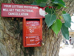
Indian Postal Service
The Department of Posts functioning under the brand name India Post , is a government operated postal system in India; it is generally referred to within India as "the post office"....
, the India
India
India , officially the Republic of India , is a country in South Asia. It is the seventh-largest country by geographical area, the second-most populous country with over 1.2 billion people, and the most populous democracy in the world...
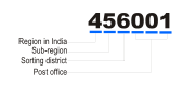
n postal administration. PIN stands for Postal Index Number and the code is 6 digits long. The PIN was introduced on August 15, 1972.
Structure
There are nine PIN zones in India, including eight regional zones and one functional zone. The first digit of the PIN code indicates the region in which a given post office falls in. The second digit indicates the sub-region, and the third digit indicates the sorting district within the region. The final three digits are assigned to individual post offices.The nine PIN zones cover the Indian states and union territories as follows:
- 1 - DelhiDelhiDelhi , officially National Capital Territory of Delhi , is the largest metropolis by area and the second-largest by population in India, next to Mumbai. It is the eighth largest metropolis in the world by population with 16,753,265 inhabitants in the Territory at the 2011 Census...
, HaryanaHaryanaHaryana is a state in India. Historically, it has been a part of the Kuru region in North India. The name Haryana is found mentioned in the 12th century AD by the apabhramsha writer Vibudh Shridhar . It is bordered by Punjab and Himachal Pradesh to the north, and by Rajasthan to the west and south...
, Punjab, Himachal PradeshHimachal PradeshHimachal Pradesh is a state in Northern India. It is spread over , and is bordered by the Indian states of Jammu and Kashmir on the north, Punjab on the west and south-west, Haryana and Uttar Pradesh on the south, Uttarakhand on the south-east and by the Tibet Autonomous Region on the east...
, Jammu & Kashmir(including Pakistan-administered KashmirPakistan-administered KashmirAzad Kashmir borders the Pakistani provinces of Punjab and Khyber Pakhtunkhwa to the west, the Wakhan Corridor of Afghanistan to the north west, the Xinjiang Uyghur Autonomous Region of People's Republic of China to the north and the Indian-administered state of Jammu and Kashmir, to the east.A...
), ChandigarhChandigarhChandigarh is a union territory of India that serves as the capital of two states, Haryana and Punjab. The name Chandigarh translates as "The Fort of Chandi". The name is from an ancient temple called Chandi Mandir, devoted to the Hindu goddess Chandi, in the city... - 2 - Uttar PradeshUttar PradeshUttar Pradesh abbreviation U.P. , is a state located in the northern part of India. With a population of over 200 million people, it is India's most populous state, as well as the world's most populous sub-national entity...
, UttarakhandUttarakhandUttarakhand , formerly Uttaranchal, is a state in the northern part of India. It is often referred to as the Land of Gods due to the many holy Hindu temples and cities found throughout the state, some of which are among Hinduism's most spiritual and auspicious places of pilgrimage and worship... - 3 - RajasthanRajasthanRājasthān the land of Rajasthanis, , is the largest state of the Republic of India by area. It is located in the northwest of India. It encompasses most of the area of the large, inhospitable Great Indian Desert , which has an edge paralleling the Sutlej-Indus river valley along its border with...
, Gujarat, Daman and Diu, Dadra & Nagar Haveli - 4 - GoaGoaGoa , a former Portuguese colony, is India's smallest state by area and the fourth smallest by population. Located in South West India in the region known as the Konkan, it is bounded by the state of Maharashtra to the north, and by Karnataka to the east and south, while the Arabian Sea forms its...
, MaharashtraMaharashtraMaharashtra is a state located in India. It is the second most populous after Uttar Pradesh and third largest state by area in India...
, Madhya PradeshMadhya PradeshMadhya Pradesh , often called the Heart of India, is a state in central India. Its capital is Bhopal and Indore is the largest city....
, Chattisgarh - 5 - Andhra PradeshAndhra PradeshAndhra Pradesh , is one of the 28 states of India, situated on the southeastern coast of India. It is India's fourth largest state by area and fifth largest by population. Its capital and largest city by population is Hyderabad.The total GDP of Andhra Pradesh is $100 billion and is ranked third...
, KarnatakaKarnatakaKarnataka , the land of the Kannadigas, is a state in South West India. It was created on 1 November 1956, with the passing of the States Reorganisation Act and this day is annually celebrated as Karnataka Rajyotsava... - 6 - Tamil NaduTamil NaduTamil Nadu is one of the 28 states of India. Its capital and largest city is Chennai. Tamil Nadu lies in the southernmost part of the Indian Peninsula and is bordered by the union territory of Pondicherry, and the states of Kerala, Karnataka, and Andhra Pradesh...
, KeralaKeralaor Keralam is an Indian state located on the Malabar coast of south-west India. It was created on 1 November 1956 by the States Reorganisation Act by combining various Malayalam speaking regions....
, Pondicherry, LakshadweepLakshadweepLakshadweep , formerly known as the Laccadive, Minicoy, and Amindivi Islands, is a group of islands in the Laccadive Sea, 200 to 440 km off the coast of the South West Indian state of Kerala... - 7 - OrissaOrissaOrissa , officially Odisha since Nov 2011, is a state of India, located on the east coast of India, by the Bay of Bengal. It is the modern name of the ancient nation of Kalinga, which was invaded by the Maurya Emperor Ashoka in 261 BC. The modern state of Orissa was established on 1 April...
, West BengalWest BengalWest Bengal is a state in the eastern region of India and is the nation's fourth-most populous. It is also the seventh-most populous sub-national entity in the world, with over 91 million inhabitants. A major agricultural producer, West Bengal is the sixth-largest contributor to India's GDP...
, Arunachal PradeshArunachal PradeshArunachal Pradesh is a state of India, located in the far northeast. It borders the states of Assam and Nagaland to the south, and shares international borders with Burma in the east, Bhutan in the west, and the People's Republic of China in the north. The majority of the territory is claimed by...
, NagalandNagalandNagaland is a state in the far north-eastern part of India. It borders the state of Assam to the west, Arunachal Pradesh and part of Assam to the north, Burma to the east and Manipur to the south. The state capital is Kohima, and the largest city is Dimapur...
, ManipurManipurManipur is a state in northeastern India, with the city of Imphal as its capital. Manipur is bounded by the Indian states of Nagaland to the north, Mizoram to the south and Assam to the west; it also borders Burma to the east. It covers an area of...
, MizoramMizoramMizoram is one of the Seven Sister States in North Eastern India, sharing borders with the states of Tripura, Assam, Manipur and with the neighbouring countries of Bangladesh and Burma. Mizoram became the 23rd state of India on 20 February 1987. Its capital is Aizawl. Mizoram is located in the...
, TripuraTripuraTripura is a state in North-East India, with an area of . It is the third smallest state of India, according to area. Tripura is surrounded by Bangladesh on the north, south, and west. The Indian states of Assam and Mizoram lie to the east. The capital is Agartala and the main languages spoken are...
, MeghalayaMeghalayaMeghalaya is a state in north-eastern India. The word "Meghalaya" literally means the Abode of Clouds in Sanskrit and other Indic languages. Meghalaya is a hilly strip in the eastern part of the country about 300 km long and 100 km wide, with a total area of about 8,700 sq mi . The...
, Andaman & Nicobar Islands - 8 - BiharBiharBihar is a state in eastern India. It is the 12th largest state in terms of geographical size at and 3rd largest by population. Almost 58% of Biharis are below the age of 25, which is the highest proportion in India....
, JharkhandJharkhandJharkhand is a state in eastern India. It was carved out of the southern part of Bihar on 15 November 2000. Jharkhand shares its border with the states of Bihar to the north, Uttar Pradesh and Chhattisgarh to the west, Orissa to the south, and West Bengal to the east... - 9 - Army Post office(APO) and Field Post office(FPO)
| First 2/3 Digits of PIN | Postal Circle |
|---|---|
| 11 | Delhi |
| 12 and 13 | Haryana |
| 14 to 15 | Punjab |
| 16 | Chandigarh |
| 17 | Himachal Pradesh |
| 18 to 19 | Jammu & Kashmir |
| 20 to 28 | Uttar Pradesh/Uttrakhand |
| 30 to 34 | Rajasthan |
| 36 to 39 | Gujarat |
| 40 | Goa |
| 40 to 44 | Maharastra |
| 45 to 48 | Madhya Pradesh |
| 49 | Chattisgarh |
| 50 to 53 | Andhra Pradesh |
| 56 to 59 | Karnataka |
| 60 to 64 | Tamil Nadu |
| 67 to 69 | Kerala |
| 682 | Lakshadweep (Islands) |
| 70 to 74 | West Bengal |
| 744 | Andaman & Nicobar Islands |
| 75 to 77 | Orissa |
| 78 | Assam |
| 79 | Arunachal Pradesh |
| 793, 794, 783123 | Meghalaya |
| 795 | Manipur |
| 796 | Mizoram |
| 799 | Tripura |
| 80 to 85 | Bihar and Jharkhand |