

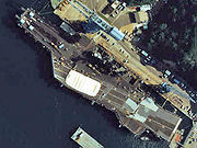
Port of Yokosuka
Encyclopedia
Port of Yokohama
The is operated by the Port and Harbor Bureau of the City of Yokohama in Japan. It opens onto Tokyo Bay. The port is located at a latitude of 35.27.–00°N and a longitude of 139.38–46°E. To the south lies the Port of Yokosuka; to the north, the ports of Kawasaki and Tokyo.-Facilities:Yokohama Port...
on Tokyo Bay
Tokyo Bay
is a bay in the southern Kantō region of Japan. Its old name was .-Geography:Tokyo Bay is surrounded by the Bōsō Peninsula to the east and the Miura Peninsula to the west. In a narrow sense, Tokyo Bay is the area north of the straight line formed by the on the Miura Peninsula on one end and on...
. Under the Ports and Harbors Law of Japan
Japan
Japan is an island nation in East Asia. Located in the Pacific Ocean, it lies to the east of the Sea of Japan, China, North Korea, South Korea and Russia, stretching from the Sea of Okhotsk in the north to the East China Sea and Taiwan in the south...
it is classified as an Important Port. The city of Yokosuka
Yokosuka, Kanagawa
is a city located in Kanagawa, Japan. As of 2010, the city had an estimated population of 419,067 and a population density of 4,160 people per km². It covered an area of 100.62 km²...
administers the port.
The Port of Yokosuka has 100 berths of length 4.5 m or more. It covers 13 areas from Oppama in the north to Kurihama and Nobi in the south. Kurihama is the place where Commodore Matthew Perry landed in 1853. Since then it has been developed for military, shipping, and ferry traffic. The U.S. Navy Base
United States Fleet Activities Yokosuka
U.S. Fleet Activities Yokosuka, or Commander, Fleet Activities Yokosuka is a United States Navy base, in Yokosuka, Japan. Its mission is to maintain and operate base facilities for the logistic, recreational, administrative support and service of the U.S. Naval Forces Japan, U.S. 7th Fleet and...
and the Maritime Self-Defense force
Japan Self-Defense Forces
The , or JSDF, occasionally referred to as JSF or SDF, are the unified military forces of Japan that were established after the end of the post–World War II Allied occupation of Japan. For most of the post-war period the JSDF was confined to the islands of Japan and not permitted to be deployed...
base lie within the Port of Yokosuka.
Located near the Nissan Oppama plant, Yokosuka is a major port for shipping of automobiles. The fishing fleet brings in tuna
Tuna
Tuna is a salt water fish from the family Scombridae, mostly in the genus Thunnus. Tuna are fast swimmers, and some species are capable of speeds of . Unlike most fish, which have white flesh, the muscle tissue of tuna ranges from pink to dark red. The red coloration derives from myoglobin, an...
and other ocean products. Tokyo-Wan Ferry
Tokyo-Wan Ferry
The is Japanese car ferry operator. Its line links Yokosuka, Kanagawa and Futtsu, Chiba, across Tokyo Bay in some 40 minutes. Headquartered in Yokosuka, the company started its service from 1957. The ferry started to accept PASMO smart cards from June 2008....
links Yokosuka with the Port of Kanaya in Futtsu
Futtsu, Chiba
is a city located in Chiba Prefecture, Japan. As of September 2010, the city had an estimated population of 47,705 and the population density of 232 persons per km²...
, Chiba Prefecture
Chiba Prefecture
is a prefecture of Japan located in the Kantō region and the Greater Tokyo Area. Its capital is Chiba City.- History :Chiba Prefecture was established on June 15, 1873 with the merger of Kisarazu Prefecture and Inba Prefecture...
. Other ferries go to Tokyo
Tokyo
, ; officially , is one of the 47 prefectures of Japan. Tokyo is the capital of Japan, the center of the Greater Tokyo Area, and the largest metropolitan area of Japan. It is the seat of the Japanese government and the Imperial Palace, and the home of the Japanese Imperial Family...
, Izu Ōshima
Izu Oshima
is a volcanic island in the Izu Islands and administered by the Tokyo Metropolitan government, Japan, lies about 100 km south of Tokyo, 22 km east of the Izu Peninsula and 36 km southwest of Bōsō Peninsula. serves as the local government of the island...
, and Ōita
Oita, Oita
is the capital city of Ōita Prefecture located on the island of Kyushu, Japan.- Demographics and geography :Ōita is the most populous city in Ōita Prefecture...
in Kyūshū
Kyushu
is the third largest island of Japan and most southwesterly of its four main islands. Its alternate ancient names include , , and . The historical regional name is referred to Kyushu and its surrounding islands....
.
External links
- Port of Yokosuka at City of Yokosuka official site (in Japanese)