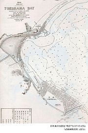
Port of Yokohama
Encyclopedia

Yokohama
is the capital city of Kanagawa Prefecture and the second largest city in Japan by population after Tokyo and most populous municipality of Japan. It lies on Tokyo Bay, south of Tokyo, in the Kantō region of the main island of Honshu...
in Japan
Japan
Japan is an island nation in East Asia. Located in the Pacific Ocean, it lies to the east of the Sea of Japan, China, North Korea, South Korea and Russia, stretching from the Sea of Okhotsk in the north to the East China Sea and Taiwan in the south...
. It opens onto Tokyo Bay
Tokyo Bay
is a bay in the southern Kantō region of Japan. Its old name was .-Geography:Tokyo Bay is surrounded by the Bōsō Peninsula to the east and the Miura Peninsula to the west. In a narrow sense, Tokyo Bay is the area north of the straight line formed by the on the Miura Peninsula on one end and on...
. The port is located at a latitude of 35.27.–00°N and a longitude of 139.38–46°E. To the south lies the Port of Yokosuka
Port of Yokosuka
The lies to the south of the Port of Yokohama on Tokyo Bay. Under the Ports and Harbors Law of Japan it is classified as an Important Port. The city of Yokosuka administers the port....
; to the north, the ports of Kawasaki
Kawasaki, Kanagawa
is a city located in Kanagawa Prefecture, Japan, between Tokyo and Yokohama. It is the 9th most populated city in Japan and one of the main cities forming the Greater Tokyo Area and Keihin Industrial Area....
and Tokyo
Tokyo
, ; officially , is one of the 47 prefectures of Japan. Tokyo is the capital of Japan, the center of the Greater Tokyo Area, and the largest metropolitan area of Japan. It is the seat of the Japanese government and the Imperial Palace, and the home of the Japanese Imperial Family...
.
Facilities
Yokohama Port has ten major piers. Honmoku Pier is the port's core facility with 24 berths.http://www.city.yokohama.jp/me/port/en/overview/honmoku.html Osanbashi PierOsanbashi Pier
is the main international pier at the Port of Yokohama, located in Naka Ward, Yokohama, Japan. Ōsanbashi is the oldest pier in Yokohama, originally constructed between 1889 and 1896.To meet modern demands, Ōsanbashi was reconstructed between 1987 and 2002...
handles passenger traffic including cruises, and has customs, immigration and quarantine facilities for international travel.http://www.city.yokohama.jp/me/port/en/overview/osanbashi.html. Detamachi, the "banana pier," is outfitted for receiving fresh fruits and vegetables.http://www.city.yokohama.jp/me/port/en/overview/detamachi.html Daikoku Pier, on an artificial island measuring 321 hectares, houses a million square meters of warehouse space.http://www.city.yokohama.jp/me/port/en/overview/daikoku.html Seven berths of Mizuho Pier are used by the United States Forces Japan
United States Forces Japan
The refers to the various divisions of the United States Armed Forces that are stationed in Japan. Under the Treaty of Mutual Cooperation and Security between the United States and Japan, the United States is obliged to defend Japan in close cooperation with the Japan Self-Defense Forces for...
.http://www.city.yokohama.jp/me/port/en/overview/mizuho.html Additional piers handle timber and serve other functions.
History
The Treaty of Amity and CommerceTreaty of Amity and Commerce (United States-Japan)
The , also called Harris Treaty, between the United States and Japan was signed at the Ryōsen-ji in Shimoda on July 29, 1858. It opened the ports of Yokohama and four other Japanese cities to American trade and granted extraterritoriality to foreigners, among other stipulations.-The Treaty:The...
of 1858 specified Kanagawa as an open port. The Port of Yokohama opened the following year. The port was devastated by the Great Kantō Earthquake
1923 Great Kanto earthquake
The struck the Kantō plain on the Japanese main island of Honshū at 11:58:44 am JST on September 1, 1923. Varied accounts hold that the duration of the earthquake was between 4 and 10 minutes...
of 1923.
Statistics
In 2006, the Port of Yokohama served 42,622 ships. It handled 138,220,075 tons of cargo. The total value of the cargo was 11,666,790 million yenJapanese yen
The is the official currency of Japan. It is the third most traded currency in the foreign exchange market after the United States dollar and the euro. It is also widely used as a reserve currency after the U.S. dollar, the euro and the pound sterling...
. http://www.city.yokohama.jp/me/port/statistics/data/2006/2006annual_pro01_e.pdf
External links
- Port of Yokohama (in English)

