
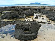
Polystrate fossil
Encyclopedia
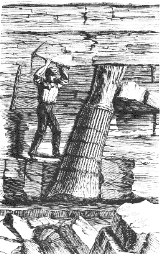
A Polystrate fossil
is a fossil of a single organism (such as a tree trunk) that extends through more than one geological stratum
. Entire "fossil forests" of such upright fossil tree trunks and stumps have been found worldwide, i.e. in the Eastern United States
, Eastern Canada
, England
, France
, Germany
, and Australia
, typically associated with coal-bearing strata. Within Carboniferous
coal-bearing strata, it is also very common to find what are called Stigmaria (root stocks) within the same stratum. Stigmaria
are completely absent in post-Carboniferous strata, which contain either coal, polystrate trees, or both. The word polystrate is not a standard geological
term. This term is typically only found in creationist publications.
 In geology
, such fossils are referred to as upright fossils, trunks, or trees. Brief periods of rapid sedimentation favor their formation. Upright fossils are typically found in layers associated with an actively subsiding coastal plain or rift basin, or with the accumulation of volcanic material around a periodically erupting stratovolcano
. Typically, this period of rapid sedimentation was followed by a period of time, decades to thousands of years long, characterized by very slow or no accumulation of sediments. In river delta
s and other coastal plain settings, rapid sedimentation is often the end result of a brief period of accelerated subsidence of an area of coastal plain relative to sea level caused by salt tectonics
, global sea level rise, growth faulting, continental margin
collapse, or some combination of these factors. For example, geologists such as John W. F. Waldron and Michael C. Rygel have argued that the rapid burial and preservation of polystrate fossil trees found at Joggins, Nova Scotia
was the direct result of rapid subsidence, caused by salt tectonics within an already subsiding pull apart basin
, and resulting rapid accumulation of sediments. The specific layers containing polystrate fossils occupy only a very limited fraction of the total area of any of these basins.
, occur buried within the lahar
s and other volcanic deposits comprising the Eocene
Lamar River Formation as the result of periods of rapid sedimentation associated with explosive volcanism. This type of volcanism generates and deposits large quantities of loose volcanic material as a blanket over the slope of a volcano
as happened during the 1991 eruption of Mount Pinatubo
. Both during and for years after a period of volcanism occurs, lahars and normal stream activity wash this loose volcanic material downslope. These processes result in the rapid burial of large areas of the surrounding countryside beneath several meters of sediment as directly observed during the 1991 eruption of Mount Pinatubo. As is the case of modern lahar deposits, the sedimentary layers containing upright trees of the Yellowstone petrified forest are discontinuous and very limited in areal extent. Individual layers containing upright trees and individual buried forests occupy only a very small fraction of the total area of Yellowstone National Park
.
s) throughout the strata containing upright fossils at Joggins, Nova Scotia, Yellowstone petrified forests, coal mines of the Black Warrior Basin
of Alabama
, and many other locations. The layer immediately underlying coal seams, often called either "seatearth
or underclay", typically either consists of or contains a paleosol. Paleosols are soils which were formed by subaerial
weathering
during periods of very slow or no accumulation of sediments. Later, renewed sedimentation buried these soils to create paleosols. These paleosols are identified on the basis of the presence of structures and microstructures unique to soils; animal burrows and molds of plant roots of various sizes and types; recognizable soil profile development; and alteration of minerals by soil processes. In many cases, these paleosols are virtually identical to modern soils.
Geologists who have studied upright fossils found in sedimentary rocks exposed in various outcrops for the last 30 years have described the upright fossil trees as being deeply rooted in place and typically rooted in recognizable paleosol
s. This is in sharp contrast to the claims made by creationists such as Harold Coffin and N. A. Rupke. Geologists, such as Falcon and Rygel et al., have published detailed field sketches and pictures of upright tree fossils with intact root systems, which are rooted within recognizable paleosols. In case of the upright fossil trees of the Yellowstone
petrified forests, geologists – again in sharp disagreement with creationists like Harold Coffin – found that the upright fossil trees, except for relatively short stumps, are rooted in place within the underlying sediments. Typically, the sediments within which trees are rooted have paleosols developed within them. Either pictures or diagrams of the Yellowstone upright fossil trees having intact root systems developed within paleosols found within these strata have been published in Retallack (1981, 1997).
by geologists, specific assemblages of the types of trees found as upright fossils occupied brackish water, even saline coastal swamps much like modern mangrove
swamps. Thus, finding marine and brackish water fossils associated with these trees is no different than finding brackish water or marine animals living in modern mangrove swamps.
A detailed study of the microstructure of fossils, which have been traditionally identified as “Spirorbis” in the geological literature, by Taylor and Vinn (2006) revealed that they consist of the remains of at least two completely different animals. They discovered that the “Spirorbis” fossils found in sedimentary strata, including the Joggins and other Carboniferous coal measures, deposited from the Ordovician
to Triassic
periods are the remains of an extinct order of lophophorates
(now called microconchids) unrelated to modern marine tube worms (Annelid
s) to which the genus Spirorbis belongs. This contradicts arguments made by Harold Coffin and other creationists that "Spirorbis" fossils within strata containing polystrate fossils indicate their deposition in a marine environment, because these fossils are classified as the remains of extinct fresh and brackish water microconchids instead of the remains of the marine genera Spirorbis as they have been misidentified in the geologic literature.
or historic sediments. These buried upright trees demonstrate that conventional geologic processes are capable of burying and preserving trees in an upright position such that in time, they will become fossilized.
, Skamania County, Washington, and Mount Pinatubo, Philippines. At Mount St. Helens, both unfossilized and partially fossilized trees were observed in many outcrops of volcanic debris and mud flows (lahars) and pyroclastic flow deposits, which date from 1885 to over 30,000 BP., along the South Toutle and other rivers. Late Holocene forests of upright trees have also been observed as occurring within the volcanic deposits of other Cascade Range
volcanoes. In a few years after the eruption of Mount Pinatubo
in 1991, the erosion of loose pyroclastic deposits covering its slopes created a series of volcanic lahars, which ultimately buried large parts of the countryside along major streams draining these slopes beneath several meters of volcanic sediments. The repeated deposition of sediments by volcanic lahars and sediment filled rivers not only created innumerable polystrate trees, but also “polystrate” telephone poles, churches, and houses, over a period a few years. The volcanic deposits enclosing these modern upright trees are often virtually identical in their sedimentary structures, external and internal layering, texture, buried soils, and other general character to the volcanic deposits containing the Yellowstone buried forests. As in case of modern forests buried by lahars, the individual buried forests of the Yellowstone Petrified Forest and the layers containing them are very limited in their areal extent.
and deltaic
sediments underlying the surface of the Mississippi River Delta
and the Atchafalaya Basin
of Louisiana
. In one case, borrow pits dug in the natural levees of Bayou Teche
near Patterson, Louisiana
, have exposed completely buried, 4 to 6-foot (1.2 to 1.8 meters) high, upright trunks of cypress
trees. Northeast of Donaldsonville, Louisiana
, a borrow pit excavated for fill used to maintain nearby artificial levees, exposed three levels of rooted upright tree trunks stacked on top of each other lying completely buried beneath the surface of Point Houmas, a patch of floodplain lying within a meander loop of the current course of the Mississippi River. While searching for buried archaeological sites, archaeologists excavated a 12 ft (3.6 meter) high upright rooted cypress tree completely buried within a natural levee of the Atchafalaya River
within the Indian Bayou Wildlife Management Area just south of Krotz Springs, Louisiana
. Radiocarbon dates and historic documents collected for this archaeological survey, during which this and other upright trees were found, of the Indian Bayou Wildlife Management Area demonstrated that these upright trees were buried in the 1800s, during the initial diversion of Mississippi River
's flow into the Atchafalaya River.
upright trees have been found buried beneath glacial deposits within North America along the southern edge of the Laurentide ice sheet
. These buried forests were created when the southern edge of the Laurentide ice sheet locally dammed valleys. As a result, meltwater lakes filled these valleys and submerged forests within them. Sediments released by the melting of the adjacent ice sheet rapidly filled these lakes, which quickly buried and preserved the submerged forests lying within them. One forest of in situ, 24,000 year-old unfossilized upright trees was exposed by excavations for a quarry near Charleston, Illinois
. Excavations for a tailings pond about Marquette, Michigan
, exposed an in situ forest of unfossilized trees, which are about 10,000 years old, buried in glacial lake and stream sediments.
Fossil
Fossils are the preserved remains or traces of animals , plants, and other organisms from the remote past...
is a fossil of a single organism (such as a tree trunk) that extends through more than one geological stratum
Stratum
In geology and related fields, a stratum is a layer of sedimentary rock or soil with internally consistent characteristics that distinguish it from other layers...
. Entire "fossil forests" of such upright fossil tree trunks and stumps have been found worldwide, i.e. in the Eastern United States
United States
The United States of America is a federal constitutional republic comprising fifty states and a federal district...
, Eastern Canada
Canada
Canada is a North American country consisting of ten provinces and three territories. Located in the northern part of the continent, it extends from the Atlantic Ocean in the east to the Pacific Ocean in the west, and northward into the Arctic Ocean...
, England
England
England is a country that is part of the United Kingdom. It shares land borders with Scotland to the north and Wales to the west; the Irish Sea is to the north west, the Celtic Sea to the south west, with the North Sea to the east and the English Channel to the south separating it from continental...
, France
France
The French Republic , The French Republic , The French Republic , (commonly known as France , is a unitary semi-presidential republic in Western Europe with several overseas territories and islands located on other continents and in the Indian, Pacific, and Atlantic oceans. Metropolitan France...
, Germany
Germany
Germany , officially the Federal Republic of Germany , is a federal parliamentary republic in Europe. The country consists of 16 states while the capital and largest city is Berlin. Germany covers an area of 357,021 km2 and has a largely temperate seasonal climate...
, and Australia
Australia
Australia , officially the Commonwealth of Australia, is a country in the Southern Hemisphere comprising the mainland of the Australian continent, the island of Tasmania, and numerous smaller islands in the Indian and Pacific Oceans. It is the world's sixth-largest country by total area...
, typically associated with coal-bearing strata. Within Carboniferous
Carboniferous
The Carboniferous is a geologic period and system that extends from the end of the Devonian Period, about 359.2 ± 2.5 Mya , to the beginning of the Permian Period, about 299.0 ± 0.8 Mya . The name is derived from the Latin word for coal, carbo. Carboniferous means "coal-bearing"...
coal-bearing strata, it is also very common to find what are called Stigmaria (root stocks) within the same stratum. Stigmaria
Stigmaria
Stigmaria are a type of branching tree root fossil found in Carboniferous rocks. They were the roots of coal forest lycopsid trees such as Sigillaria and Lepidodendron. Each trunk tended to have four of those roots. Stigmaria is a form taxon, as the genus and species of the plant bearing the root...
are completely absent in post-Carboniferous strata, which contain either coal, polystrate trees, or both. The word polystrate is not a standard geological
Geology
Geology is the science comprising the study of solid Earth, the rocks of which it is composed, and the processes by which it evolves. Geology gives insight into the history of the Earth, as it provides the primary evidence for plate tectonics, the evolutionary history of life, and past climates...
term. This term is typically only found in creationist publications.
Geological explanation
Geology
Geology is the science comprising the study of solid Earth, the rocks of which it is composed, and the processes by which it evolves. Geology gives insight into the history of the Earth, as it provides the primary evidence for plate tectonics, the evolutionary history of life, and past climates...
, such fossils are referred to as upright fossils, trunks, or trees. Brief periods of rapid sedimentation favor their formation. Upright fossils are typically found in layers associated with an actively subsiding coastal plain or rift basin, or with the accumulation of volcanic material around a periodically erupting stratovolcano
Stratovolcano
A stratovolcano, also known as a composite volcano, is a tall, conical volcano built up by many layers of hardened lava, tephra, pumice, and volcanic ash. Unlike shield volcanoes, stratovolcanoes are characterized by a steep profile and periodic, explosive eruptions...
. Typically, this period of rapid sedimentation was followed by a period of time, decades to thousands of years long, characterized by very slow or no accumulation of sediments. In river delta
River delta
A delta is a landform that is formed at the mouth of a river where that river flows into an ocean, sea, estuary, lake, reservoir, flat arid area, or another river. Deltas are formed from the deposition of the sediment carried by the river as the flow leaves the mouth of the river...
s and other coastal plain settings, rapid sedimentation is often the end result of a brief period of accelerated subsidence of an area of coastal plain relative to sea level caused by salt tectonics
Salt tectonics
500px|thumb|rightSalt tectonics is concerned with the geometries and processes associated with the presence of significant thicknesses of evaporites containing rock salt within a stratigraphic sequence of rocks...
, global sea level rise, growth faulting, continental margin
Continental margin
The continental margin is the zone of the ocean floor that separates the thin oceanic crust from thick continental crust. Continental margins constitute about 28% of the oceanic area....
collapse, or some combination of these factors. For example, geologists such as John W. F. Waldron and Michael C. Rygel have argued that the rapid burial and preservation of polystrate fossil trees found at Joggins, Nova Scotia
Joggins, Nova Scotia
Joggins is a Canadian rural community located in western Cumberland County, Nova Scotia. On July 7, 2008 a 15 km length of the coast constituting the Joggins Fossil Cliffs was officially inscribed on the World Heritage List.- History :...
was the direct result of rapid subsidence, caused by salt tectonics within an already subsiding pull apart basin
Pull Apart Basin
250px|thumb|[[Cami Lake]] in [[Tierra del Fuego]] develops on a [[Patagonian Ice Sheet|glacially]] excavated pull apart basin along the [[Magallanes-Fagnano Fault]], hence its elongated form...
, and resulting rapid accumulation of sediments. The specific layers containing polystrate fossils occupy only a very limited fraction of the total area of any of these basins.
Yellowstone
The upright fossil trees of the Yellowstone petrified forest in the Gallatin RangeGallatin Range
The Gallatin Range is located in the U.S. states of Montana and Wyoming and includes more than 10 mountains over . The highest peak in the range is Electric Peak at . The Gallatin Range was named after Albert Gallatin, the longest-serving US Secretary of the Treasury and one of the negotiators of...
, occur buried within the lahar
Lahar
A lahar is a type of mudflow or debris flow composed of a slurry of pyroclastic material, rocky debris, and water. The material flows down from a volcano, typically along a river valley. The term is a shortened version of "berlahar" which originated in the Javanese language of...
s and other volcanic deposits comprising the Eocene
Eocene
The Eocene Epoch, lasting from about 56 to 34 million years ago , is a major division of the geologic timescale and the second epoch of the Paleogene Period in the Cenozoic Era. The Eocene spans the time from the end of the Palaeocene Epoch to the beginning of the Oligocene Epoch. The start of the...
Lamar River Formation as the result of periods of rapid sedimentation associated with explosive volcanism. This type of volcanism generates and deposits large quantities of loose volcanic material as a blanket over the slope of a volcano
Volcano
2. Bedrock3. Conduit 4. Base5. Sill6. Dike7. Layers of ash emitted by the volcano8. Flank| 9. Layers of lava emitted by the volcano10. Throat11. Parasitic cone12. Lava flow13. Vent14. Crater15...
as happened during the 1991 eruption of Mount Pinatubo
Mount Pinatubo
Mount Pinatubo is an active stratovolcano located on the island of Luzon, near the tripoint of the Philippine provinces of Zambales, Tarlac, and Pampanga. It is located in the Tri-Cabusilan Mountain range separating the west coast of Luzon from the central plains, and is west of the dormant and...
. Both during and for years after a period of volcanism occurs, lahars and normal stream activity wash this loose volcanic material downslope. These processes result in the rapid burial of large areas of the surrounding countryside beneath several meters of sediment as directly observed during the 1991 eruption of Mount Pinatubo. As is the case of modern lahar deposits, the sedimentary layers containing upright trees of the Yellowstone petrified forest are discontinuous and very limited in areal extent. Individual layers containing upright trees and individual buried forests occupy only a very small fraction of the total area of Yellowstone National Park
Yellowstone National Park
Yellowstone National Park, established by the U.S. Congress and signed into law by President Ulysses S. Grant on March 1, 1872, is a national park located primarily in the U.S. state of Wyoming, although it also extends into Montana and Idaho...
.
Fossil soils
Geologists have recognized innumerable fossil soils (paleosolPaleosol
In the geosciences, paleosol can have two meanings. The first meaning, common in geology and paleontology, refers to a former soil preserved by burial underneath either sediments or volcanic deposits , which in the case of older deposits have lithified into rock...
s) throughout the strata containing upright fossils at Joggins, Nova Scotia, Yellowstone petrified forests, coal mines of the Black Warrior Basin
Black Warrior Basin
The Black Warrior Basin is a geologic sedimentary basin of western Alabama and northern Mississippi in the United States. It is named for the Black Warrior River and is developed for coal and coalbed methane production, as well as for conventional oil and natural gas production...
of Alabama
Alabama
Alabama is a state located in the southeastern region of the United States. It is bordered by Tennessee to the north, Georgia to the east, Florida and the Gulf of Mexico to the south, and Mississippi to the west. Alabama ranks 30th in total land area and ranks second in the size of its inland...
, and many other locations. The layer immediately underlying coal seams, often called either "seatearth
Seatearth
Seatearth is a British coal mining term, which is used in the geological literature. As noted by Jackson, a seatearth is the layer of sedimentary rock underlying a coal seam. Seatearths have also been called seat earth, "seat rock", or "seat stone" in the geologic literature. Depending on its...
or underclay", typically either consists of or contains a paleosol. Paleosols are soils which were formed by subaerial
Subaerial
The term subaerial is mainly used in geology to describe events or structures that are located at the Earth's surface...
weathering
Weathering
Weathering is the breaking down of rocks, soils and minerals as well as artificial materials through contact with the Earth's atmosphere, biota and waters...
during periods of very slow or no accumulation of sediments. Later, renewed sedimentation buried these soils to create paleosols. These paleosols are identified on the basis of the presence of structures and microstructures unique to soils; animal burrows and molds of plant roots of various sizes and types; recognizable soil profile development; and alteration of minerals by soil processes. In many cases, these paleosols are virtually identical to modern soils.
Geologists who have studied upright fossils found in sedimentary rocks exposed in various outcrops for the last 30 years have described the upright fossil trees as being deeply rooted in place and typically rooted in recognizable paleosol
Paleosol
In the geosciences, paleosol can have two meanings. The first meaning, common in geology and paleontology, refers to a former soil preserved by burial underneath either sediments or volcanic deposits , which in the case of older deposits have lithified into rock...
s. This is in sharp contrast to the claims made by creationists such as Harold Coffin and N. A. Rupke. Geologists, such as Falcon and Rygel et al., have published detailed field sketches and pictures of upright tree fossils with intact root systems, which are rooted within recognizable paleosols. In case of the upright fossil trees of the Yellowstone
Yellowstone National Park
Yellowstone National Park, established by the U.S. Congress and signed into law by President Ulysses S. Grant on March 1, 1872, is a national park located primarily in the U.S. state of Wyoming, although it also extends into Montana and Idaho...
petrified forests, geologists – again in sharp disagreement with creationists like Harold Coffin – found that the upright fossil trees, except for relatively short stumps, are rooted in place within the underlying sediments. Typically, the sediments within which trees are rooted have paleosols developed within them. Either pictures or diagrams of the Yellowstone upright fossil trees having intact root systems developed within paleosols found within these strata have been published in Retallack (1981, 1997).
Formation by regeneration
Geologists have also found that some of the larger upright fossil trees found within Carboniferous coal-bearing strata show evidence of regeneration after being partially buried by sediments. In these cases, the trees were clearly alive when they were partially buried by sediments. The accumulated sediment was insufficient to kill the trees immediately because of their size. As a result, some of them developed a new set of roots from their trunks just below the new ground surface. Until they either died or were overwhelmed by the accumulating sediments, these trees would likely continue to regenerate by adding height and new roots with each increment of sediment, eventually leaving several meters of former "trunk" buried underground as sediments accumulated.Association with marine fossils
Geologists find nothing anomalous about upright fossil trees found in Carboniferous coal-bearing strata being associated with marine or brackish water fossils. Because they lived on subsiding coastal plains or pull-apart basins open to the coast, it was quite frequent for subsidence to periodically outpace the accumulation of sediments such that adjacent shallow marine waters would periodically inundate coastal plains in which the trees were buried. As a result, sediments, containing marine fossils, would periodically accumulate within these areas before being replaced by coastal swamps as sediments either filled in the shallow sea or sea level fell. Also, according to ecological reconstructionsPaleoecology
Paleoecology uses data from fossils and subfossils to reconstruct the ecosystems of the past. It involves the study of fossil organisms and their associated remains, including their life cycle, living interactions, natural environment, and manner of death and burial to reconstruct the...
by geologists, specific assemblages of the types of trees found as upright fossils occupied brackish water, even saline coastal swamps much like modern mangrove
Mangrove
Mangroves are various kinds of trees up to medium height and shrubs that grow in saline coastal sediment habitats in the tropics and subtropics – mainly between latitudes N and S...
swamps. Thus, finding marine and brackish water fossils associated with these trees is no different than finding brackish water or marine animals living in modern mangrove swamps.
A detailed study of the microstructure of fossils, which have been traditionally identified as “Spirorbis” in the geological literature, by Taylor and Vinn (2006) revealed that they consist of the remains of at least two completely different animals. They discovered that the “Spirorbis” fossils found in sedimentary strata, including the Joggins and other Carboniferous coal measures, deposited from the Ordovician
Ordovician
The Ordovician is a geologic period and system, the second of six of the Paleozoic Era, and covers the time between 488.3±1.7 to 443.7±1.5 million years ago . It follows the Cambrian Period and is followed by the Silurian Period...
to Triassic
Triassic
The Triassic is a geologic period and system that extends from about 250 to 200 Mya . As the first period of the Mesozoic Era, the Triassic follows the Permian and is followed by the Jurassic. Both the start and end of the Triassic are marked by major extinction events...
periods are the remains of an extinct order of lophophorates
Lophophore
The lophophore is a characteristic feeding organ possessed by four major groups of animals: the Brachiopoda, Bryozoa, Entoprocta, and Phoronida. All lophophores are found in aquatic organisms.-Characteristics:...
(now called microconchids) unrelated to modern marine tube worms (Annelid
Annelid
The annelids , formally called Annelida , are a large phylum of segmented worms, with over 17,000 modern species including ragworms, earthworms and leeches...
s) to which the genus Spirorbis belongs. This contradicts arguments made by Harold Coffin and other creationists that "Spirorbis" fossils within strata containing polystrate fossils indicate their deposition in a marine environment, because these fossils are classified as the remains of extinct fresh and brackish water microconchids instead of the remains of the marine genera Spirorbis as they have been misidentified in the geologic literature.
Holocene examples
According to scientists, polystrate fossils are just fossils which were buried in a relatively short time span either by one large depositional event or by several smaller ones. Geologists see no need to invoke a global flood to explain upright fossils. This position of geologists is supported by numerous examples, which have been found at numerous locations, of upright trees completely buried within either late HoloceneHolocene
The Holocene is a geological epoch which began at the end of the Pleistocene and continues to the present. The Holocene is part of the Quaternary period. Its name comes from the Greek words and , meaning "entirely recent"...
or historic sediments. These buried upright trees demonstrate that conventional geologic processes are capable of burying and preserving trees in an upright position such that in time, they will become fossilized.
Volcanic deposits
At this time, the best documented occurrences of unfossilized buried upright trees are found within historic and late Holocene volcanic deposits of Mount St. HelensMount St. Helens
Mount St. Helens is an active stratovolcano located in Skamania County, Washington, in the Pacific Northwest region of the United States. It is south of Seattle, Washington and northeast of Portland, Oregon. Mount St. Helens takes its English name from the British diplomat Lord St Helens, a...
, Skamania County, Washington, and Mount Pinatubo, Philippines. At Mount St. Helens, both unfossilized and partially fossilized trees were observed in many outcrops of volcanic debris and mud flows (lahars) and pyroclastic flow deposits, which date from 1885 to over 30,000 BP., along the South Toutle and other rivers. Late Holocene forests of upright trees have also been observed as occurring within the volcanic deposits of other Cascade Range
Cascade Range
The Cascade Range is a major mountain range of western North America, extending from southern British Columbia through Washington and Oregon to Northern California. It includes both non-volcanic mountains, such as the North Cascades, and the notable volcanoes known as the High Cascades...
volcanoes. In a few years after the eruption of Mount Pinatubo
Mount Pinatubo
Mount Pinatubo is an active stratovolcano located on the island of Luzon, near the tripoint of the Philippine provinces of Zambales, Tarlac, and Pampanga. It is located in the Tri-Cabusilan Mountain range separating the west coast of Luzon from the central plains, and is west of the dormant and...
in 1991, the erosion of loose pyroclastic deposits covering its slopes created a series of volcanic lahars, which ultimately buried large parts of the countryside along major streams draining these slopes beneath several meters of volcanic sediments. The repeated deposition of sediments by volcanic lahars and sediment filled rivers not only created innumerable polystrate trees, but also “polystrate” telephone poles, churches, and houses, over a period a few years. The volcanic deposits enclosing these modern upright trees are often virtually identical in their sedimentary structures, external and internal layering, texture, buried soils, and other general character to the volcanic deposits containing the Yellowstone buried forests. As in case of modern forests buried by lahars, the individual buried forests of the Yellowstone Petrified Forest and the layers containing them are very limited in their areal extent.
Deltaic deposits
Within excavations for Interstate Highway 10, borrow pits, landfills, and archaeological surveys, unfossilized upright trees have also been found buried within late Holocene, even historic, fluvialFluvial
Fluvial is used in geography and Earth science to refer to the processes associated with rivers and streams and the deposits and landforms created by them...
and deltaic
River delta
A delta is a landform that is formed at the mouth of a river where that river flows into an ocean, sea, estuary, lake, reservoir, flat arid area, or another river. Deltas are formed from the deposition of the sediment carried by the river as the flow leaves the mouth of the river...
sediments underlying the surface of the Mississippi River Delta
Mississippi River Delta
The Mississippi River Delta is the modern area of land built up by alluvium deposited by the Mississippi River as it slows down and enters the Gulf of Mexico...
and the Atchafalaya Basin
Atchafalaya Basin
The Atchafalaya Basin, or Atchafalaya Swamp, is the largest swamp in the United States. Located in south central Louisiana, it is a combination of wetlands and river delta area where the Atchafalaya River and the Gulf of Mexico converge. The river stretches from near Simmesport in the north...
of Louisiana
Louisiana
Louisiana is a state located in the southern region of the United States of America. Its capital is Baton Rouge and largest city is New Orleans. Louisiana is the only state in the U.S. with political subdivisions termed parishes, which are local governments equivalent to counties...
. In one case, borrow pits dug in the natural levees of Bayou Teche
Bayou Teche
The Bayou Teche is a waterway of great cultural significance in south central Louisiana in the United States. Bayou Teche was the Mississippi River's main course when it developed a delta about 2,800 to 4,500 years ago...
near Patterson, Louisiana
Patterson, Louisiana
Patterson is a small city in St. Mary Parish, Louisiana, United States. The population was 6,530 at the 2000 census. It is part of the Morgan City Micropolitan Statistical Area.-History:...
, have exposed completely buried, 4 to 6-foot (1.2 to 1.8 meters) high, upright trunks of cypress
Taxodium
Taxodium is a genus of one to three species of extremely flood-tolerant conifers in the cypress family, Cupressaceae...
trees. Northeast of Donaldsonville, Louisiana
Donaldsonville, Louisiana
Donaldsonville is a city in and the parish seat of Ascension Parish, Louisiana, United States, along the west bank of the Mississippi River. The population was 7,605 at the 2000 census. It is part of the Baton Rouge Metropolitan Statistical Area.-History:Acadians began to settle in the area in...
, a borrow pit excavated for fill used to maintain nearby artificial levees, exposed three levels of rooted upright tree trunks stacked on top of each other lying completely buried beneath the surface of Point Houmas, a patch of floodplain lying within a meander loop of the current course of the Mississippi River. While searching for buried archaeological sites, archaeologists excavated a 12 ft (3.6 meter) high upright rooted cypress tree completely buried within a natural levee of the Atchafalaya River
Atchafalaya River
The Atchafalaya River is a distributary of the Mississippi River and Red River in south central Louisiana in the United States. It flows south, just west of the Mississippi River....
within the Indian Bayou Wildlife Management Area just south of Krotz Springs, Louisiana
Krotz Springs, Louisiana
Krotz Springs is a town in St. Landry Parish, Louisiana on the Atchafalaya River. The population was 1,219 at the 2000 census. It is part of the Opelousas–Eunice Micropolitan Statistical Area.-History:...
. Radiocarbon dates and historic documents collected for this archaeological survey, during which this and other upright trees were found, of the Indian Bayou Wildlife Management Area demonstrated that these upright trees were buried in the 1800s, during the initial diversion of Mississippi River
Mississippi River
The Mississippi River is the largest river system in North America. Flowing entirely in the United States, this river rises in western Minnesota and meanders slowly southwards for to the Mississippi River Delta at the Gulf of Mexico. With its many tributaries, the Mississippi's watershed drains...
's flow into the Atchafalaya River.
Glacial deposits
Unfossilized, late PleistocenePleistocene
The Pleistocene is the epoch from 2,588,000 to 11,700 years BP that spans the world's recent period of repeated glaciations. The name pleistocene is derived from the Greek and ....
upright trees have been found buried beneath glacial deposits within North America along the southern edge of the Laurentide ice sheet
Laurentide ice sheet
The Laurentide Ice Sheet was a massive sheet of ice that covered hundreds of thousands of square miles, including most of Canada and a large portion of the northern United States, multiple times during Quaternary glacial epochs. It last covered most of northern North America between c. 95,000 and...
. These buried forests were created when the southern edge of the Laurentide ice sheet locally dammed valleys. As a result, meltwater lakes filled these valleys and submerged forests within them. Sediments released by the melting of the adjacent ice sheet rapidly filled these lakes, which quickly buried and preserved the submerged forests lying within them. One forest of in situ, 24,000 year-old unfossilized upright trees was exposed by excavations for a quarry near Charleston, Illinois
Charleston, Illinois
Charleston is a city in and the county seat of Coles County, Illinois, United States. The population was 21,838 as of the 2010 census. The city is home to Eastern Illinois University and has close ties with its neighbor Mattoon, Illinois...
. Excavations for a tailings pond about Marquette, Michigan
Marquette, Michigan
Marquette is a city in the U.S. state of Michigan and the county seat of Marquette County. The population was 21,355 at the 2010 census, making it the most populated city of the Upper Peninsula. Marquette is a major port on Lake Superior, primarily for shipping iron ore and is the home of Northern...
, exposed an in situ forest of unfossilized trees, which are about 10,000 years old, buried in glacial lake and stream sediments.
Geological
- Clarke, J., 1999, Palaeosols, Young Earth/Anti-evolutionist Page, DMD Publishing (Glenn Morton).
- Ferguson, L., 1988, Formation of Joggin upright fossil trees, The Joggins Fossil Cliffs, Fossils of Nova Scotia, Nova Scotia Museum, Nova Scotia.
- Lindsay, D., 2009, "Polystrate" Fossils, The Creation/Evolution Controversy, Don Lindsay's home page
- Macrea, A. 1997, "Polystrate" Tree Fossils, TalkOrigins ArchiveTalkOrigins ArchiveThe TalkOrigins Archive is a website that presents mainstream science perspectives on the antievolution claims of young-earth, old-earth, and "intelligent design" creationists...
- Nelson, J., and S. Elrick, 2011, A 300 Million Year Old Pennsylvanian Age Mire Forest. Coal Section, Illinois State Geological Survey, Champaign, Illinois.