

Poluwat
Encyclopedia
Coral
Corals are marine animals in class Anthozoa of phylum Cnidaria typically living in compact colonies of many identical individual "polyps". The group includes the important reef builders that inhabit tropical oceans and secrete calcium carbonate to form a hard skeleton.A coral "head" is a colony of...
atoll
Atoll
An atoll is a coral island that encircles a lagoon partially or completely.- Usage :The word atoll comes from the Dhivehi word atholhu OED...
and a municipality
Municipality
A municipality is essentially an urban administrative division having corporate status and usually powers of self-government. It can also be used to mean the governing body of a municipality. A municipality is a general-purpose administrative subdivision, as opposed to a special-purpose district...
of Chuuk
Chuuk
Chuuk — formerly Truk, Ruk, Hogoleu, Torres, Ugulat, and Lugulus — is an island group in the south western part of the Pacific Ocean. It comprises one of the four states of the Federated States of Micronesia , along with Kosrae, Pohnpei, and Yap. Chuuk is the most populous of the FSM's...
state, Federated States of Micronesia
Federated States of Micronesia
The Federated States of Micronesia or FSM is an independent, sovereign island nation, made up of four states from west to east: Yap, Chuuk, Pohnpei and Kosrae. It comprises approximately 607 islands with c...
.
Geography
Poluwat is located in the northwestern region (Oksoritod), and there in the western area (PattiwPattiw
Pattiw is the name of the westernmost area of the State of Chuuk in the Federated States of Micronesia, consisting of the three islands or atolls of Houk, Poluwat and Pollap, with a total land area of 7.17 km² and a population of 2,736 . Pattiw is one of three areas of Chuuk's Northwestern Region,...
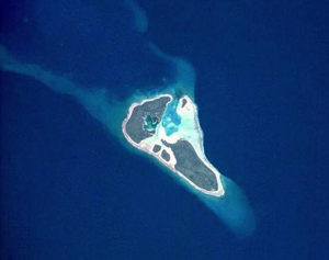
) of Chuuk state. The location is 07°21′26"N 149°12′01"E. The atoll has five islets lying on the rim of the reef, with an aggregate land area of 3.4 km², listed counterclockwise starting at Poluwat in the southeast:
- Polowat (east)
- Angelab (north rim)
- To (north rim)
- Alei (west)
- Sau (south)
Since Polowat Atoll has only a small lagoon
Lagoon
A lagoon is a body of shallow sea water or brackish water separated from the sea by some form of barrier. The EU's habitat directive defines lagoons as "expanses of shallow coastal salt water, of varying salinity or water volume, wholly or partially separated from the sea by sand banks or shingle,...
, in comparison with most Micronesia
Micronesia
Micronesia is a subregion of Oceania, comprising thousands of small islands in the western Pacific Ocean. It is distinct from Melanesia to the south, and Polynesia to the east. The Philippines lie to the west, and Indonesia to the southwest....
n atolls, the total size is only 7 km². Alet in the west and Poluwat in the east, the two largest islands of the atoll, have breadfruit
Breadfruit
Breadfruit is a species of flowering tree in the mulberry family, Moraceae, growing throughout Southeast Asia and most Pacific Ocean islands...
trees at the middle and coconut
Coconut
The coconut palm, Cocos nucifera, is a member of the family Arecaceae . It is the only accepted species in the genus Cocos. The term coconut can refer to the entire coconut palm, the seed, or the fruit, which is not a botanical nut. The spelling cocoanut is an old-fashioned form of the word...
palms along the shores.
Along the northern rim of the reef, between Poluwat and Alet, are Bangelab Islet and To Islet. The southern corner of the atoll is marked by Sau Islet, with 0.02 km² the smallest. These smaller islets are wooded, but have few coconut palms.
Polowat Atoll and specificially Alet Island are the westernmost land features of Chuuk state.
There are three villages on the west side of Poluwat Island, facing the lagoon, with a total population of 1.015 (census
Census
A census is the procedure of systematically acquiring and recording information about the members of a given population. It is a regularly occurring and official count of a particular population. The term is used mostly in connection with national population and housing censuses; other common...
of 2000), from north to south:
- Relong
- Lukaf
- Rewou
Uranie Bank, which extends about 26 km southeast from Puluwat, has depths of 11 to 61 meters. Together with Poluwat Atoll, it might be considered part of a larger, mostly submerged atoll structure, with a total size of 332 km².
Enderby Bank, with a depth of 16 meters, coral, lies about 5 km WNW of Alet Island.
History
The Japanese garrisonGarrison
Garrison is the collective term for a body of troops stationed in a particular location, originally to guard it, but now often simply using it as a home base....
during World War II
World War II
World War II, or the Second World War , was a global conflict lasting from 1939 to 1945, involving most of the world's nations—including all of the great powers—eventually forming two opposing military alliances: the Allies and the Axis...
was composed of 2,769 IJA
IJA
IJA can refer to:* Imperial Japanese Army* International Jugglers' Association* International Jousting Association* Instituto Justo Arosemena* The Internet Journal of Anesthesiology* International Judges Association* Empress Ija...
men of the 11th Independent Mixed Regiment under the command of Colonel Tatsuo Yasui and 243 IJN
IJN
The abbreviation IJN may refer to:* International Justice Network or IJNetwork, a Human Rights Organization* Imperial Japanese Navy, the navy of Japan from 1868 until it was dissolved in 1947* Institut Jean Nicod, a French interdisciplinary research center...
men. Due to a food shortage 2 of the 3 army battalions were moved to Truk but still, 335 IJA soldiers and 211 IJN soldiers on the island died of hunger and illness. Japanese defence bunkers from the years leading up to World War II and a white concrete lighthouse tower, 40 meters high, stand on the northwest end of Alet. There are also many Japanese relics from WWII on Alet, including a beached ship that was attacked by American aircraft. At the bottom of the larger lagoon lies an American plane, also from WWII. The Japanese Lighthouse, is listed on the U.S. National Register of Historic Places
National Register of Historic Places
The National Register of Historic Places is the United States government's official list of districts, sites, buildings, structures, and objects deemed worthy of preservation...
.