
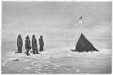
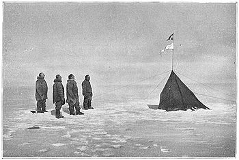
Polheim
Encyclopedia
Roald Amundsen
Roald Engelbregt Gravning Amundsen was a Norwegian explorer of polar regions. He led the first Antarctic expedition to reach the South Pole between 1910 and 1912 and he was the first person to reach both the North and South Poles. He is also known as the first to traverse the Northwest Passage....
's name for his camp (the first ever) at the South Pole
South Pole
The South Pole, also known as the Geographic South Pole or Terrestrial South Pole, is one of the two points where the Earth's axis of rotation intersects its surface. It is the southernmost point on the surface of the Earth and lies on the opposite side of the Earth from the North Pole...
. He arrived there on December 14, 1911, along with four other members of his expedition; Helmer Hanssen
Helmer Hanssen
Helmer Julius Hanssen was a Norwegian polar explorer, and one of the first five to reach the South Pole on the expedition of Roald Amundsen.- His life :Helmer Hanssen was born in Bjørnskinn, on the island of Andøya in the northern part of Norway...
, Olav Bjaaland
Olav Bjaaland
Olav Bjaaland was a Norwegian ski champion from Telemark. In 1911, he was one of the first five men to reach the South Pole as part of an expedition led by Roald Amundsen.- His life :...
, Oscar Wisting
Oscar Wisting
Oscar Adolf Wisting was a Norwegian polar explorer. Together with Roald Amundsen he was the first person to reach both the North and South Poles.- Biography :...
, and Sverre Hassel
Sverre Hassel
Sverre Helge Hassel was a Norwegian polar explorer and one of the first five people to reach the South Pole.- Biography :...
.
Calculations
At the first estimated position of the South Pole, Amundsen declared "So we plant you, dear flag, on the South Pole, and give the plain on which it lies the name King Haakon VII's Plateau." Both the NorwegianFlag of Norway
The flag of Norway is red with an indigo blue Scandinavian cross outlined in white that extends to the edges of the flag; the vertical part of the cross is shifted to the hoist side in the style of the Dannebrog, the flag of Denmark.- History :...
and Fram
Fram
Fram is a ship that was used in expeditions of the Arctic and Antarctic regions by the Norwegian explorers Fridtjof Nansen, Otto Sverdrup, Oscar Wisting, and Roald Amundsen between 1893 and 1912...
's flag were planted.
Due to the historical disputes over the claims of polar explorers prior to Amundsen's expedition, particularly the competing claims of Frederick Cook
Frederick Cook
Frederick Albert Cook was an American explorer and physician, noted for his claim of having reached the North Pole on April 21, 1908. This would have been a year before April 6, 1909, the date claimed by Robert Peary....
and Robert Peary
Robert Peary
Robert Edwin Peary, Sr. was an American explorer who claimed to have been the first person, on April 6, 1909, to reach the geographic North Pole...
to have reached the North Pole
North Pole
The North Pole, also known as the Geographic North Pole or Terrestrial North Pole, is, subject to the caveats explained below, defined as the point in the northern hemisphere where the Earth's axis of rotation meets its surface...
first, Amundsen took special care in making his polar observations.
Approaching the Geographic South Pole (or North Pole) the meridians of longitude
Longitude
Longitude is a geographic coordinate that specifies the east-west position of a point on the Earth's surface. It is an angular measurement, usually expressed in degrees, minutes and seconds, and denoted by the Greek letter lambda ....
converge, eventually making a measure of longitude meaningless, as a degree of longitude will become smaller and smaller. At the pole itself, (assuming one has accurate enough instruments), all meridians meet. Amundsen reasoned that the extra effort in obtaining longitude could be saved, and he focused on latitude
Latitude
In geography, the latitude of a location on the Earth is the angular distance of that location south or north of the Equator. The latitude is an angle, and is usually measured in degrees . The equator has a latitude of 0°, the North pole has a latitude of 90° north , and the South pole has a...
. Amundsen had adopted this strategy after attending a lecture at The Royal Geographical Society in London
London
London is the capital city of :England and the :United Kingdom, the largest metropolitan area in the United Kingdom, and the largest urban zone in the European Union by most measures. Located on the River Thames, London has been a major settlement for two millennia, its history going back to its...
in November 1909, given by the British astronomer and geographer, Arthur Robert Hinks
Arthur Robert Hinks
Arthur Robert Hinks, CBE, FRS was a British astronomer and geographer..As an astronomer, he is best known for his work in determining the distance from the Sun to the Earth from 1900–1909: for this achievement, he was awarded the Gold Medal of the Royal Astronomical Society and was elected a...
. In his lecturer on Surveying and Cartography at Cambridge University, Hinks put forward this theory when discussing the subject of determining positions near the Pole.
With the instruments he had, Amundsen estimated that he could determine the position of the pole by no better than a nautical mile. In order to ensure that there was no doubt that his expedition had in fact reached the South Pole, he determined to encircle, or "box" the pole.
Three members of the expedition were sent out from the current estimated position of the pole, one continuing on the current expedition track and two at right angles to this direction. Each skier continued 10 miles and erected a spare sledge runner with a black flag and note for Robert Falcon Scott
Robert Falcon Scott
Captain Robert Falcon Scott, CVO was a Royal Navy officer and explorer who led two expeditions to the Antarctic regions: the Discovery Expedition, 1901–04, and the ill-fated Terra Nova Expedition, 1910–13...
when and if he arrived. Scott did not arrive until more than a month later. The note contained the position to Amundsen's camp.
While the skiers erected the encircling markers, Amundsen took altitudes of the sun for fixing his position. Since his theodolite
Theodolite
A theodolite is a precision instrument for measuring angles in the horizontal and vertical planes. Theodolites are mainly used for surveying applications, and have been adapted for specialized purposes in fields like metrology and rocket launch technology...
had been damaged, observations were made with a sextant, the sun slowly circling the camp in 24 hours, and never setting.
From these calculations, Amundsen determined that their current position was approximately 5.5 miles from the mathematical South Pole point. This point had been "boxed" by the skiers.
On December 17 Amundsen proceeded to his estimate of the true South Pole position, and took additional observations for 24 hours, two men standing watch for each observation, and co-signing each other's navigation books. Again, this was to ensure that there was no doubt as to the expedition attaining the pole. Four out of the five men in the polar party were trained navigators, Olav Bjaaland being the only one without such training.
From these calculations, it was determined that they were still 1.5 miles from the pole, and two men were sent to erect additional pennants.
Finally, Amundsen added still more pennants to cover the remaining area. In this way, the pole had been boxed three times all told.
The official expedition camera had been damaged en route to the pole, so the only photographs taken were from an amateur camera brought by expedition member, Olav Bjaaland.
On December 18, 1911, Amundsen's expedition left Polheim, leaving behind his reserve tent, along with a letter for Scott and a letter intended for Scott to deliver to King Haakon VII
Haakon VII
Haakon VII may refer to:People* Haakon VII of Norway , King of Norway Ships* HNoMS King Haakon VII, a Royal Norwegian Navy escort ship in commission from 1942 to 1951...
in the event that Amundsen failed to return. Both letters were later found with the bodies of Scott and his companions, and were further proof that Amundsen had attained the pole.
When Amundsen's calculations were verified, it was found that his final camp lay within 2,500 yards of the mathematical South Pole, a remarkable achievement given the instruments available. In addition, it had been ascertained that expedition member Helmer Hanssen
Helmer Hanssen
Helmer Julius Hanssen was a Norwegian polar explorer, and one of the first five to reach the South Pole on the expedition of Roald Amundsen.- His life :Helmer Hanssen was born in Bjørnskinn, on the island of Andøya in the northern part of Norway...
—one of the expedition members that had been skiing in a grid pattern between the 'box' markers—came to within two hundred yards of the mathematical South Pole on one of his runs.
Sources
Roald Amundsen wrote about the expedition in Sydpolen published in two volumes in 1912–1913. The work was translated into English by A. G. Chater, and published as The South Pole: An Account of the Norwegian Antarctic Expedition in the "Fram," 1910–1912. (London: John Murray. 1912)Other sources
- Huntford, RolandRoland HuntfordRoland Huntford is an author, principally of biographies of Polar explorers. He lives in Cambridge, and was formerly Scandinavian correspondent of The Observer, also acting as their winter sports correspondent...
(1979) Scott and Amundsen (Hodder & Stoughton Ltd) ISBN 978-0340195659 - Huntford, Roland (1999) The Last Place on Earth (Modern Library Exploration) ISBN 978-0375754746