
Pleasant Hill, Saskatoon
Encyclopedia
Pleasant Hill is a neighborhood of Saskatoon
, Saskatchewan
, Canada
. The Governments are undertaking a major re-vitalization project of Pleasant Hill. $3.5 million dollars is being invested in the business, and residential areas as well as in St. Mary's School. Together the Saskatoon Urban Renewal Project, the provincial government and the Western Economic Diversification project of the federal Government will result in neighbourhood overhauls. 29 lots zoned for business along 20th Street will be levelled and modern commercial upgrades put into place. Selected lots along Avenue N and Avenue O zoned as residential will be demolished to make way for affordable and decent homes. St. Mary's School will receive major renovations or replacement, possibly even a new community centre.
 The first name of the hill of this area was called Willoughby Hill.
From 1884 to 1890, Dr. J.H.C. Wiloughby was Saskatoon's first post master and first physician on the east side of the River until after providing medical assistance to Middleton's troops during the Riel Rebellion (Revolution). From 1885 to 1900 he departed to Regina. John Henry C. returned with his wife (Miss Hilliard) and homesteaded at Willoughby Hill. His homestead was Section 30 Township 36 Range 5 West of the 3rd Meridian
, and his home was located at the present location of St. Paul's Hospital. Being that he was a physician, his home was one of the first hospitals of the City of Saskatoon. In 1903 he helped to establish the first telephone in the area. He also became one of Saskatoon's first city councillors from 1907-1908.
The boundaries of the Pleasant Hill community used to extend west of Avenue W to Circle Drive, but in the early 1990s the City of Saskatoon redrew many of its neighbourhood boundaries; as a result, the section west of Avenue W was renamed Meadowgreen
.
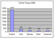 There are 4,415 people living in the Pleasant Hill community area. The majority of homes in the Pleasant Hill Community are Multi Unit Dwellings. This area was first settled at the turn of the 20th century, age of homes are generally built before 1908 and typically sell between $58,995 and $68,269. Pleasant Hill has been a Vibrant Communities Partner since 2001 and benefits from various community developments by Quint Development Corporation and Children's Hunger and Education Project. In Pleasant Hill in 2006, the average household size was 2.2. The homeownership was 25.5% with an average home selling price of $
54,107.
is located in the University of Saskatchewan
Land Management area, and Saskatoon City Hospital
is located in City Park. The Saskatoon Police Service Headquarters location is within the Central Business District
located at 130 4th Avenue North. The Central Division oversees the Central Business District
, the Riversdale Business District, SIAST
and nine other residential areas. Pleasant Hill is served by the City of Saskatoon Saskatoon Fire & Protective Services, Fire Hall number 1 and head office is located at 125 Idylwyld Drive
South, Riversdale.
bus routes #1, #2, #50 and #60. Route #5 also runs along Rusholme Road, a block north of the neighbourhood boundary.
22nd Street (Highway 14
) is a major thoroughfare through Saskatoon. Highway 7
has its junction at (Highway 14
. Highway 14
connects with Asquith
, Biggar
Wilkie
, Unity
, and Macklin en route to Alberta
.
Saskatchewan Music Educators has introduced drum circles entitled Circles of Peace in various schools, of which the Pleasant Hill Community School is one.
Saskatoon
Saskatoon is a city in central Saskatchewan, Canada, on the South Saskatchewan River. Residents of the city of Saskatoon are called Saskatonians. The city is surrounded by the Rural Municipality of Corman Park No. 344....
, Saskatchewan
Saskatchewan
Saskatchewan is a prairie province in Canada, which has an area of . Saskatchewan is bordered on the west by Alberta, on the north by the Northwest Territories, on the east by Manitoba, and on the south by the U.S. states of Montana and North Dakota....
, Canada
Canada
Canada is a North American country consisting of ten provinces and three territories. Located in the northern part of the continent, it extends from the Atlantic Ocean in the east to the Pacific Ocean in the west, and northward into the Arctic Ocean...
. The Governments are undertaking a major re-vitalization project of Pleasant Hill. $3.5 million dollars is being invested in the business, and residential areas as well as in St. Mary's School. Together the Saskatoon Urban Renewal Project, the provincial government and the Western Economic Diversification project of the federal Government will result in neighbourhood overhauls. 29 lots zoned for business along 20th Street will be levelled and modern commercial upgrades put into place. Selected lots along Avenue N and Avenue O zoned as residential will be demolished to make way for affordable and decent homes. St. Mary's School will receive major renovations or replacement, possibly even a new community centre.
Layout
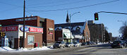
Within the Core Neighbourhoods Suburban Development Area (West Side), the neighbourhood of Pleasant Hill is triangular in shape and is south of 23rd Street, North-west of the rail line which runs diagonally and east of Avenue W South. Streets are laid out east and west, avenues are laid out running north and south. The whole of the Pleasant Hill community is laid out in a grid pattern.History
From 1884 to 1890, Dr. J.H.C. Wiloughby was Saskatoon's first post master and first physician on the east side of the River until after providing medical assistance to Middleton's troops during the Riel Rebellion (Revolution). From 1885 to 1900 he departed to Regina. John Henry C. returned with his wife (Miss Hilliard) and homesteaded at Willoughby Hill. His homestead was Section 30 Township 36 Range 5 West of the 3rd Meridian
106th meridian west
The meridian 106° west of Greenwich is a line of longitude that extends from the North Pole across the Arctic Ocean, North America, the Pacific Ocean, the Southern Ocean, and Antarctica to the South Pole....
, and his home was located at the present location of St. Paul's Hospital. Being that he was a physician, his home was one of the first hospitals of the City of Saskatoon. In 1903 he helped to establish the first telephone in the area. He also became one of Saskatoon's first city councillors from 1907-1908.
The boundaries of the Pleasant Hill community used to extend west of Avenue W to Circle Drive, but in the early 1990s the City of Saskatoon redrew many of its neighbourhood boundaries; as a result, the section west of Avenue W was renamed Meadowgreen
Meadowgreen, Saskatoon
Meadowgreen community is a geographically localized subdivision of the Confederation Suburban Development Area in the city of Saskatoon, Saskatchewan, Canada. Meadowgreen is surrounded by an abundance of green space and walking trails without being a River side neighbourhood. The buffer zone...
.
Demographics
Canadian dollar
The Canadian dollar is the currency of Canada. As of 2007, the Canadian dollar is the 7th most traded currency in the world. It is abbreviated with the dollar sign $, or C$ to distinguish it from other dollar-denominated currencies...
54,107.
Protected properties
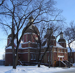
- Ukrainian Catholic Cathedral of St. GeorgeCathedral of St. George (Saskatoon)The Ukrainian Catholic Cathedral of St. George was built by architect the Very Reverend Philip Ruh, O.M.I. in 1923. The Ukrainian Greek Catholic Cathedral of St. George in Pleasant Hill, Core Neighbourhoods SDA, Saskatoon, Canada is the Episcopal See of the Bishop of the Saskatoon Eparchy.The...
located at 222 Avenue M South and built by architect the Very Reverend Philip Ruh, O.M.I. in 1923
Potential heritage properties
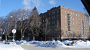
- Nurses Residence, St. Paul's Hospital
- Pleasant Hill School
- St. Mary's School
- The Bosnia Club
Education
- Pleasant Hill School Public Elementary School
- St. Mary's School Separate Elementary School
Public services
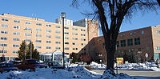
Saskatoon Light and Power provides electrical utilities to all Saskatoon neighborhoods which existed prior to 1958. Water is treated and supplied by the City of Saskatoon Water and Wastewater Treatment Branch. St. Paul's Hospital is located in Pleasant Hill, Royal University HospitalRoyal University Hospital
Royal University Hospital, often abbreviated RUH, is one of three hospitals in Saskatoon, Saskatchewan. It is located on the University of Saskatchewan campus. RUH is a teaching hospital and closely tied to the College of Medicine within the university. It was opened on May 14, 1955 by...
is located in the University of Saskatchewan
University of Saskatchewan
The University of Saskatchewan is a Canadian public research university, founded in 1907, and located on the east side of the South Saskatchewan River in Saskatoon, Saskatchewan, Canada. An "Act to establish and incorporate a University for the Province of Saskatchewan" was passed by the...
Land Management area, and Saskatoon City Hospital
Saskatoon City Hospital
Saskatoon City Hospital is a public hospital in the City Park neighborhood of Saskatoon, Saskatchewan. It was originally opened in 1909, and it was the second municipal hospital in Canada. The hospital is operated by the Saskatoon Health Region....
is located in City Park. The Saskatoon Police Service Headquarters location is within the Central Business District
Central Business District, Saskatoon
The Central Business District is one of seven suburban development districts in Saskatoon, Saskatchewan, Canada. The central business district is Ward 6 of a Mayor-Council government represented by councillor Charlie Clark. Formerly called West Saskatoon, this area arose when the steam engines...
located at 130 4th Avenue North. The Central Division oversees the Central Business District
Central Business District, Saskatoon
The Central Business District is one of seven suburban development districts in Saskatoon, Saskatchewan, Canada. The central business district is Ward 6 of a Mayor-Council government represented by councillor Charlie Clark. Formerly called West Saskatoon, this area arose when the steam engines...
, the Riversdale Business District, SIAST
Saskatchewan Institute of Applied Science and Technology
Saskatchewan Institute of Applied Science and Technology is a diploma-granting college that has four campuses across Saskatchewan. More than 12,000 students are enrolled in its programs and has approximately 29,000 additional individual registrations....
and nine other residential areas. Pleasant Hill is served by the City of Saskatoon Saskatoon Fire & Protective Services, Fire Hall number 1 and head office is located at 125 Idylwyld Drive
Idylwyld Drive
Idylwyld Drive is an arterial road in Saskatoon, Saskatchewan. It is one of the main roads in and out of the downtown area of the city.On the south side of the Senator Sid Buckwold Bridge, it is a freeway and is known as the Idylwyld Freeway. It eventually turns into Circle Drive, just east of...
South, Riversdale.
Parks and recreation
- D.L. Hamilton Park - 1.63 acres (6,596.4 m²)
- Fred Mendel Park - 12.63 acres (51,111.8 m²)
- Pleasant Hill Rec. Unit - 2.94 acres (11,897.8 m²)
- St. George's Park - 0.93 acres (3,763.6 m²)
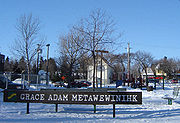
- Grace Adam Metawewinihk Park - 1.02 acres (4,127.8 m²)
- Pleasant Hill Spray Paddling Pool
Area religion
- Avalokitesvara Buddhist Temple
- St. Mary's Church
- St.George's ChurchCathedral of St. George (Saskatoon)The Ukrainian Catholic Cathedral of St. George was built by architect the Very Reverend Philip Ruh, O.M.I. in 1923. The Ukrainian Greek Catholic Cathedral of St. George in Pleasant Hill, Core Neighbourhoods SDA, Saskatoon, Canada is the Episcopal See of the Bishop of the Saskatoon Eparchy.The...
and St. George's Hall.
City transit
Pleasant Hill is serviced by the Saskatoon TransitSaskatoon Transit
Saskatoon Transit is the public transport arm of the City of Saskatoon, Saskatchewan, Canada. It operates a fleet of diesel buses. A total of 23 bus routes serve every area of the city, carrying approximately 11 million passengers in 2008...
bus routes #1, #2, #50 and #60. Route #5 also runs along Rusholme Road, a block north of the neighbourhood boundary.
22nd Street (Highway 14
Saskatchewan Highway 14
Highway 14 is a highway in the Canadian province of Saskatchewan. It runs from the intersection of Idylwyld Drive and 22nd Street in downtown Saskatoon, westward to the Albertan border where it becomes Highway 13. It is approximately 261 km long.Prior to the 1970's, Highway 14 ran the width...
) is a major thoroughfare through Saskatoon. Highway 7
Saskatchewan Highway 7
Saskatchewan Highway 7 is a major paved undivided provincial highway in the Canadian province of Saskatchewan, running from the Alberta border to Saskatoon...
has its junction at (Highway 14
Saskatchewan Highway 14
Highway 14 is a highway in the Canadian province of Saskatchewan. It runs from the intersection of Idylwyld Drive and 22nd Street in downtown Saskatoon, westward to the Albertan border where it becomes Highway 13. It is approximately 261 km long.Prior to the 1970's, Highway 14 ran the width...
. Highway 14
Saskatchewan Highway 14
Highway 14 is a highway in the Canadian province of Saskatchewan. It runs from the intersection of Idylwyld Drive and 22nd Street in downtown Saskatoon, westward to the Albertan border where it becomes Highway 13. It is approximately 261 km long.Prior to the 1970's, Highway 14 ran the width...
connects with Asquith
Asquith, Saskatchewan
-External links:*...
, Biggar
Biggar, Saskatchewan
Biggar is a town in central Saskatchewan, Canada. It is located on Highway #14, west of Saskatoon, the province’s most populous city. Biggar has become well known for its unusual town slogan, an Olympic athlete, and a world-record deer...
Wilkie
Wilkie, Saskatchewan
Wilkie is a town in Saskatchewan, Canada located at Section 5, Township 40, Range 19, west of the 3rd Meridian .On February 2, 1907, the first post office was established with the name Glenlogan at Section 4, Township 40, Range 19, west of the 3rd Meridian. The post office changed names on October...
, Unity
Unity, Saskatchewan
-Area statistics:*Lat 52°26′ N*Long 109°10′00″ W*Dominion Land Survey Section 18, Township 40, Range 22, West of the 3rd Meridian*Time zone UTC−6-Location:-See also:*List of towns in Saskatchewan...
, and Macklin en route to Alberta
Alberta
Alberta is a province of Canada. It had an estimated population of 3.7 million in 2010 making it the most populous of Canada's three prairie provinces...
.
Life
Pleasant Hill Community Association provides leisure activities for various age groups and operates out of both Pleasant Hill School and St. Mary School.Saskatchewan Music Educators has introduced drum circles entitled Circles of Peace in various schools, of which the Pleasant Hill Community School is one.
Location
| North: Mount Royal Mount Royal, Saskatoon Mount Royal is a neighbourhood on the westside of Saskatoon, Saskatchewan in the Confederation SDA. Having a population of 4.259 residents, the neighborhood consists of 3 elementary schools and 2 sister secondary schools.-Demographics:... | ||
| West: Meadowgreen Meadowgreen, Saskatoon Meadowgreen community is a geographically localized subdivision of the Confederation Suburban Development Area in the city of Saskatoon, Saskatchewan, Canada. Meadowgreen is surrounded by an abundance of green space and walking trails without being a River side neighbourhood. The buffer zone... | Pleasant Hill | East: West Industrial West Industrial, Saskatoon West Industrial is an is a light industrial area in Saskatoon, Saskatchewan, Canada. This neighborhood extends north of 11th Street, south of the rail and west of Avenue P south.-External links:**... | Riversdale |
| South: Sedco / South West Industrial South West Industrial, Saskatoon South West Industrial, also known as Holiday Park Industrial and labelled SEDCO Industrial on city maps of the 1980s and 1990s, is an industrial subdivision located in the Confederation SDA in southwest Saskatoon, Saskatchewan, Canada.-Economy:... | West Industrial |
External links
- Local Area Planning
- City of Saskatoon · Departments · Community Services · Community
- Pleasant Hill Local Area Plan
- Saskatoon Neighbourhoods Word Search Puzzle
- City of Saskatoon · Departments · Community Services · Community ...
- City of Saskatoon · Departments · Community Services · City Planning · ZAM Maps
- Populace Spring 2006