Piccaninny crater
Encyclopedia


Impact structure
The term impact structure is closely related to the terms impact crater or meteorite impact crater, and is used in cases where erosion or burial have destroyed or masked the original topographic feature with which we normally associate the term crater...
, the eroded remnant of a former impact crater
Impact crater
In the broadest sense, the term impact crater can be applied to any depression, natural or manmade, resulting from the high velocity impact of a projectile with a larger body...
, situated in northern Western Australia
Western Australia
Western Australia is a state of Australia, occupying the entire western third of the Australian continent. It is bounded by the Indian Ocean to the north and west, the Great Australian Bight and Indian Ocean to the south, the Northern Territory to the north-east and South Australia to the south-east...
. It was named after Piccaninny Creek and lies within the Purnululu (Bungle Bungle) National Park
Purnululu National Park
Purnululu National Park is a national park in the Kimberley region of Western Australia. It was declared a World Heritage Site in 2003.-Location:...
.
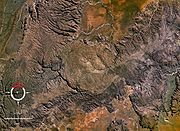
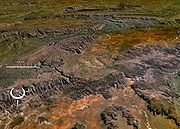
The site is marked by a circular topographic feature on top of the flat-topped sandstone
Sandstone
Sandstone is a sedimentary rock composed mainly of sand-sized minerals or rock grains.Most sandstone is composed of quartz and/or feldspar because these are the most common minerals in the Earth's crust. Like sand, sandstone may be any colour, but the most common colours are tan, brown, yellow,...
and conglomerate
Conglomerate (geology)
A conglomerate is a rock consisting of individual clasts within a finer-grained matrix that have become cemented together. Conglomerates are sedimentary rocks consisting of rounded fragments and are thus differentiated from breccias, which consist of angular clasts...
Bungle Bungle Range, clearly visible on remotely sensed images (Google Maps image). When first reported in 1983 after aerial observation, it was interpreted as either an impact structure or a cryptovolcanic
Cryptoexplosion
The term cryptoexplosion structure means an explosion of unknown cause. The term is now largely obsolete. It was once commonly used to describe sites where there was geological evidence of a large scale explosion within the Earth's crust, but no definitive evidence for the cause such as normal...
feature. Later ground examination by E.M.
Eugene Merle Shoemaker
Eugene Merle Shoemaker , American geologist, was one of the founders of the fields of planetary science....
and C.S. Shoemaker
Carolyn S. Shoemaker
Carolyn Jean Spellmann Shoemaker is an American astronomer and is a co-discoverer of Comet Shoemaker–Levy 9. She holds the record for most comets discovered by an individual.- Personal life :...
confirmed the presence of types of deformation confirming an impact origin.
The circular topographic feature is 7 km in diameter, although due to the amount of erosion the original crater may have been larger. It has been estimated that the present land surface is 1–2 km below the original crater floor. The impact event has not been dated, and must be younger than the Devonian
Devonian
The Devonian is a geologic period and system of the Paleozoic Era spanning from the end of the Silurian Period, about 416.0 ± 2.8 Mya , to the beginning of the Carboniferous Period, about 359.2 ± 2.5 Mya...
age of the rocks in the area, but is clearly not recent because of the amount of erosion.

