
Pennsylvania Route 652
Encyclopedia
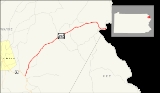
Pennsylvania Route 652, designated by the Pennsylvania Department of Transportation
(PennDOT) as State Route 0652, is a 10.57 miles (17 km) long east–west state highway
located in the northeast Pennsylvania
county of Wayne
. The western terminus of the route is at U.S. Route 6
in the Texas Township
community of Indian Orchard. The highways heads to the northeast, and reaches the eastern terminus at the New York-Pennsylvania border in Damascus Township
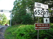
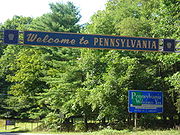
, where Route 652 crosses the Narrowsburg–Darbytown Bridge over the Delaware River
and into New York
, continuing as New York State Route 52
and Sullivan County Route 24.
The highway originated as the easternmost stretch of United States Route 106 when the United States Highway System was first put together in 1926. The route, however, was assigned as a state highway in 1920. Route 652 was once used south of the alignment, in the northern suburbs in Philadelphia. Route 652 remained on that alignment until 1946, and in 1972, the 652 designation was reassigned onto the U.S. Route 106 alignment.
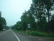
 Route 652, better known as the Beach Lake Highway, begins at a three segment intersection with U.S. Route 6
(the Grand Army of the Republic Highway) in the small community of Indian Orchard, Pennsylvania. At the southern terminus, there are several commercial buildings that serve the local residents. Route 652 heads to the northeast, passing through a short patch of woods in the area of Indian Orchard. There is a short clearing, serving some residential homes and intersected with an unnamed local road, where it leaves Indian Orchard.
Route 652 continues to the northeast out of Indian Orchard, where the surroundings of the highway became more open, with residential homes and fields surrounding the highway. The next few intersections are with local driveways, which serve the local residential homes. After a few driveways, Route 652 enters the community of Bethel. There, the highway becomes more developed, and the highway begins to pass more commercial developments. There, Route 652 intersects with Navajo Road, a local road which parallels the northbound highway. After an intersection with a local unnamed road, Route 652 leaves Bethel.
 After leaving Bethel, Route 652 continues its way northward, entering a deep patch of woodlands and paralleling to the east of Navajo Road, which intersected earlier. The deep patch continues, until there is a clearing for a commercial building, and after some more trees, the patch breaks up at Volunteer Road, a dead-end driveway. Route 652 continues now to the northeast, passing some local roads and intersecting with Gassen Road, a local highway in Berlin Township
. After Gassen Road, the surroundings of the highway become highly developed, and after a short distance, intersects with another local road.
Route 652 begins a northeastern progression, where it passes to the south of several ponds and several local residences. There are some short patches of the woodlands in the area. At an intersection with Dunn Road and Buckingham Road, Route 652 passes some local residences, and eventually becomes less developed with fields surrounding the highway in Berlin Township. At the intersection with Bayly Road, Route 652 turns on a short eastern progression and into the center of Berlin Township, where the highway becomes moderately developed, passing fields and homes. At an intersection with Trails Road, Route 652 turns to the northeast, leaving Berlin Township for Beach Lake, Pennsylvania.
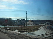
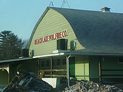 Upon entering Beach Lake, the highway enters a short patch of forests, intersecting with a local road, Rosencraft Road, and an unnamed dead-end loop road. There, Route 652 becomes highly developed, passing several residences on both the northern and southern sides of the highway. Nearby the highway is Beach Lake, the body of water for which the community is named. At an intersection with Milanville, which forks off to the north, Route 652 passes to the east of the Beach Lake Volunteer Fire Department.
There, in Beach Lake, Route 652 passes a more highly developed commercial region. After an intersection with Church Road, the highway begins a northeast progression, and leaves Beach Lake. Route 652 becomes less developed once again outside of Beach Lake, intersecting with Perkins Pond Road, crossing over a small creek in the area. After a process of a few hundred feet, the highway passes to the south of a small pond. At Perkins Pond Road, Route 652 turns to the northeast, the highway becomes known as the Beach Lake Highway on maps. The route becomes developed, passing a short set of development. At an intersection with Little Beach Lake Road, where Route 652 turns to the east and into Damascus Township
.
In Damascus Township, Route 652 continues through a moderate stretch of development and at an intersection with Trot Lane Road, the highway turns to the northeast once again. After the intersection, Route 652 passes a pond in the area of Darbytown to the south, intersecting with Clemen U Miller Road, and at Bavarian Hill Road, Route 652 continues to the east, running along the community line of Darbytown and Atco.
 In Atco and Darbytown, the highway is highly surrounded by the dense woodlans in the area. At Atco Road, Route 652 makes a dive to the south from its the rest of alignment, parallelling Plank Road to the east. Eventually, the highway leaves Atco and continues into downtown Darbytown, where the highway intersects with Peggy Runway Road, which heads southward along the Delaware River
. There, the highway parallels the Delaware River and heading eastward. At an intersection with State Route 1017, Route 652 dips to the southeast and crosses the Narrowsburg-Darbytown Bridge
and continued into New York
as New York State Route 52
and Sullivan County Route 24.
 PA 652 was first assigned in 1928 to a series of local streets in the northwestern suburb
s of Philadelphia. The southern terminus of the route was at the modern U.S. Route 30
/Old Eagle School Road intersection on the Chester
–Delaware
county line near Devon to the west and Wayne
to the east. PA 652 followed Old Eagle School Road north to King of Prussia
, where the route turned east onto East Swedesford Road. At the location of the modern U.S. Route 422
/U.S. Route 202
interchange, PA 652 turned north onto Guthrie Road, running alongside the right-of-way
of what is now the US 422 expressway to North Gulph Road. PA 652 continued north on North Gulph Road to the Valley Forge National Historical Park
, where it terminated at Pennsylvania Route 23
.
In 1946, PA 652 was transferred to the control of the local suburbs along its entire length, and control of the roads went to local highway departments. The portion of the route between Guthrie Road and PA 23 returned to state control in 1967 when Pennsylvania Route 363
was routed onto North Gulph Road.
The current alignment of Route 652 was classified as a state highway as early as 1920, nine years after the Sproul Road Bill was passed by the Pennsylvania State Legislature. The Sproul Road Bill also assigned the first state highways in Pennsylvania. There was no designation given to the highway. From 1926 to 1972, the modern routing of PA 652 was part of U.S. Route 106. The road also carried a portion of Pennsylvania Route 19
from 1927 to 1930. In 1972, US 106 was decommissioned and replaced with the PA 652 designation between Indian Orchard and the Delaware River.
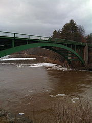 Route 652 has a consistent stretch of water crossings that helps put the highway together. The first bridge along the highway, built in 1925, was the U.S. Route 106 bridge spanning a tributary of the Delaware River. The concrete-paved span was reconstructed in 1980 and crosses the tributary into New York on a 50.85 feet (15.5 m) long span. The next bridge was the current Narrowsburg–Darbytown Bridge, built in 1954 over the Delaware. The bridge is structurally deficient according to the United States Department of Transportation
, and is in need of replacement. The bridge is 425 feet (129.5 m) long and made of steel.
The final two bridges were constructed in 1964. The first was constructed for Route 106 over Indian Orchard Brook. It is located about 500 feet (152.4 m) east of State Route 2011 (Poor Farm Road). It is a structurally deficient, 20.99 feet (6.4 m) concrete bridge. There is no recorded estimate for replacement costs. The second bridge is also over Indian Orchard Brook, and is in Texas Township. The bridge is 41.99 feet (12.8 m) long and built out of concrete, which handles an average of 6,804 commuters a year.
Pennsylvania Department of Transportation
The Pennsylvania Department of Transportation oversees transportation issues in the Commonwealth of Pennsylvania. The administrator of PennDOT is the Pennsylvania Secretary of Transportation, currently Barry Schoch Presently, PennDOT supports over of state roads and highways, about 25,000...
(PennDOT) as State Route 0652, is a 10.57 miles (17 km) long east–west state highway
State highway
State highway, state road or state route can refer to one of three related concepts, two of them related to a state or provincial government in a country that is divided into states or provinces :#A...
located in the northeast Pennsylvania
Pennsylvania
The Commonwealth of Pennsylvania is a U.S. state that is located in the Northeastern and Mid-Atlantic regions of the United States. The state borders Delaware and Maryland to the south, West Virginia to the southwest, Ohio to the west, New York and Ontario, Canada, to the north, and New Jersey to...
county of Wayne
Wayne County, Pennsylvania
As of the census of 2000, there were 47,722 people, 18,350 households, and 12,936 families residing in the county. The population density was 65 people per square mile . There were 30,593 housing units at an average density of 42 per square mile...
. The western terminus of the route is at U.S. Route 6
U.S. Route 6 in Pennsylvania
U.S. Route 6 travels east–west near the north edge of the U.S. state of Pennsylvania from the Ohio state line near Pymatuning Reservoir east to the Mid-Delaware Bridge over the Delaware River into Port Jervis, New York. It is the longest highway segment in the Commonwealth. Most of it is a...
in the Texas Township
Texas Township, Pennsylvania
Texas Township is a township in Wayne County, Pennsylvania, United States. The population was 2,569 at the 2010 census.-Geography:According to the United States Census Bureau, the township has a total area of , of which is land and , or 0.69%, is water....
community of Indian Orchard. The highways heads to the northeast, and reaches the eastern terminus at the New York-Pennsylvania border in Damascus Township
Damascus Township, Pennsylvania
Damascus Township is a township in Wayne County, Pennsylvania, United States. The population was 3,662 at the 2000 census.-Geography:According to the United States Census Bureau, the township has a total area of , of which, of it is land and of it is water.-Demographics:As of the census of 2000,...
, where Route 652 crosses the Narrowsburg–Darbytown Bridge over the Delaware River
Delaware River
The Delaware River is a major river on the Atlantic coast of the United States.A Dutch expedition led by Henry Hudson in 1609 first mapped the river. The river was christened the South River in the New Netherland colony that followed, in contrast to the North River, as the Hudson River was then...
and into New York
New York
New York is a state in the Northeastern region of the United States. It is the nation's third most populous state. New York is bordered by New Jersey and Pennsylvania to the south, and by Connecticut, Massachusetts and Vermont to the east...
, continuing as New York State Route 52
New York State Route 52
New York State Route 52 is a long state highway in the southeastern part of New York in the United States. It generally runs from west to east, beginning at the Pennsylvania state line in the Delaware River near Narrowsburg, crossing the Hudson River on the Newburgh-Beacon Bridge, and ending...
and Sullivan County Route 24.
The highway originated as the easternmost stretch of United States Route 106 when the United States Highway System was first put together in 1926. The route, however, was assigned as a state highway in 1920. Route 652 was once used south of the alignment, in the northern suburbs in Philadelphia. Route 652 remained on that alignment until 1946, and in 1972, the 652 designation was reassigned onto the U.S. Route 106 alignment.
Route description
U.S. Route 6 in Pennsylvania
U.S. Route 6 travels east–west near the north edge of the U.S. state of Pennsylvania from the Ohio state line near Pymatuning Reservoir east to the Mid-Delaware Bridge over the Delaware River into Port Jervis, New York. It is the longest highway segment in the Commonwealth. Most of it is a...
(the Grand Army of the Republic Highway) in the small community of Indian Orchard, Pennsylvania. At the southern terminus, there are several commercial buildings that serve the local residents. Route 652 heads to the northeast, passing through a short patch of woods in the area of Indian Orchard. There is a short clearing, serving some residential homes and intersected with an unnamed local road, where it leaves Indian Orchard.
Route 652 continues to the northeast out of Indian Orchard, where the surroundings of the highway became more open, with residential homes and fields surrounding the highway. The next few intersections are with local driveways, which serve the local residential homes. After a few driveways, Route 652 enters the community of Bethel. There, the highway becomes more developed, and the highway begins to pass more commercial developments. There, Route 652 intersects with Navajo Road, a local road which parallels the northbound highway. After an intersection with a local unnamed road, Route 652 leaves Bethel.
Berlin Township, Pennsylvania
Berlin Township is a township in Wayne County, Pennsylvania, United States. The population was 2,188 at the 2000 census.-Geography:According to the United States Census Bureau, the township has a total area of , of which, of it is land and of it is water.-Demographics:As of the census of 2000,...
. After Gassen Road, the surroundings of the highway become highly developed, and after a short distance, intersects with another local road.
Route 652 begins a northeastern progression, where it passes to the south of several ponds and several local residences. There are some short patches of the woodlands in the area. At an intersection with Dunn Road and Buckingham Road, Route 652 passes some local residences, and eventually becomes less developed with fields surrounding the highway in Berlin Township. At the intersection with Bayly Road, Route 652 turns on a short eastern progression and into the center of Berlin Township, where the highway becomes moderately developed, passing fields and homes. At an intersection with Trails Road, Route 652 turns to the northeast, leaving Berlin Township for Beach Lake, Pennsylvania.
There, in Beach Lake, Route 652 passes a more highly developed commercial region. After an intersection with Church Road, the highway begins a northeast progression, and leaves Beach Lake. Route 652 becomes less developed once again outside of Beach Lake, intersecting with Perkins Pond Road, crossing over a small creek in the area. After a process of a few hundred feet, the highway passes to the south of a small pond. At Perkins Pond Road, Route 652 turns to the northeast, the highway becomes known as the Beach Lake Highway on maps. The route becomes developed, passing a short set of development. At an intersection with Little Beach Lake Road, where Route 652 turns to the east and into Damascus Township
Damascus Township, Pennsylvania
Damascus Township is a township in Wayne County, Pennsylvania, United States. The population was 3,662 at the 2000 census.-Geography:According to the United States Census Bureau, the township has a total area of , of which, of it is land and of it is water.-Demographics:As of the census of 2000,...
.
In Damascus Township, Route 652 continues through a moderate stretch of development and at an intersection with Trot Lane Road, the highway turns to the northeast once again. After the intersection, Route 652 passes a pond in the area of Darbytown to the south, intersecting with Clemen U Miller Road, and at Bavarian Hill Road, Route 652 continues to the east, running along the community line of Darbytown and Atco.
Delaware River
The Delaware River is a major river on the Atlantic coast of the United States.A Dutch expedition led by Henry Hudson in 1609 first mapped the river. The river was christened the South River in the New Netherland colony that followed, in contrast to the North River, as the Hudson River was then...
. There, the highway parallels the Delaware River and heading eastward. At an intersection with State Route 1017, Route 652 dips to the southeast and crosses the Narrowsburg-Darbytown Bridge
Narrowsburg-Darbytown Bridge
The Narrowsburg–Darbytown Bridge spans the Delaware River between Darbytown, Pennsylvania and Narrowsburg, New York. Narrowsburg is located in the town of Tusten, but the hamlet along the river's edge is known as Narrowsburg because it is the narrowest part of the River.In either 1810 or 1830, the...
and continued into New York
New York
New York is a state in the Northeastern region of the United States. It is the nation's third most populous state. New York is bordered by New Jersey and Pennsylvania to the south, and by Connecticut, Massachusetts and Vermont to the east...
as New York State Route 52
New York State Route 52
New York State Route 52 is a long state highway in the southeastern part of New York in the United States. It generally runs from west to east, beginning at the Pennsylvania state line in the Delaware River near Narrowsburg, crossing the Hudson River on the Newburgh-Beacon Bridge, and ending...
and Sullivan County Route 24.
History
Suburb
The word suburb mostly refers to a residential area, either existing as part of a city or as a separate residential community within commuting distance of a city . Some suburbs have a degree of administrative autonomy, and most have lower population density than inner city neighborhoods...
s of Philadelphia. The southern terminus of the route was at the modern U.S. Route 30
U.S. Route 30 in Pennsylvania
In the U.S. state of Pennsylvania, U.S. Route 30 runs east–west across the southern part of the state, passing through Pittsburgh and Philadelphia on its way from the West Virginia state line east to the Benjamin Franklin Bridge over the Delaware River into New Jersey...
/Old Eagle School Road intersection on the Chester
Chester County, Pennsylvania
-State parks:*French Creek State Park*Marsh Creek State Park*White Clay Creek Preserve-Demographics:As of the 2010 census, the county was 85.5% White, 6.1% Black or African American, 0.2% Native American or Alaskan Native, 3.9% Asian, 0.0% Native Hawaiian, 1.8% were two or more races, and 2.4% were...
–Delaware
Delaware County, Pennsylvania
Delaware County is a county located in the U.S. state of Pennsylvania. As of 2010, the population was 558,979, making it Pennsylvania's fifth most populous county, behind Philadelphia, Allegheny, Montgomery, and Bucks counties....
county line near Devon to the west and Wayne
Wayne, Pennsylvania
Wayne is an unincorporated community located on the Main Line, centered in Delaware County, Pennsylvania, United States. While the center of Wayne is in Radnor Township, Wayne extends into both Tredyffrin Township in Chester County and Upper Merion Township in Montgomery County...
to the east. PA 652 followed Old Eagle School Road north to King of Prussia
King of Prussia, Pennsylvania
King of Prussia is a census-designated place in Upper Merion Township, Montgomery County, Pennsylvania, United States. As of the 2010 census, its population was 19,936. The community took its name in the 18th century from a local tavern named the King of Prussia Inn, which was named after...
, where the route turned east onto East Swedesford Road. At the location of the modern U.S. Route 422
U.S. Route 422
U.S. Route 422 is a long spur route of US 22 split into two segments in the U.S. states of Ohio and Pennsylvania. The western spur begins in downtown Cleveland, Ohio, and ends at Ebensburg, Pennsylvania...
/U.S. Route 202
U.S. Route 202
U.S. Route 202 is a highway stretching from Delaware to Maine, also passing through the states of Pennsylvania, New Jersey, New York, Connecticut, Massachusetts, and New Hampshire....
interchange, PA 652 turned north onto Guthrie Road, running alongside the right-of-way
Easement
An easement is a certain right to use the real property of another without possessing it.Easements are helpful for providing pathways across two or more pieces of property or allowing an individual to fish in a privately owned pond...
of what is now the US 422 expressway to North Gulph Road. PA 652 continued north on North Gulph Road to the Valley Forge National Historical Park
Valley Forge National Historical Park
Valley Forge National Historical Park is the site where the Continental Army spent the winter of 1777–1778 near Valley Forge, Pennsylvania, during the American Revolutionary War. The National Historical Park preserves the site and interprets the history of the Valley Forge encampment. ...
, where it terminated at Pennsylvania Route 23
Pennsylvania Route 23
Pennsylvania Route 23 is a state highway in southeastern Pennsylvania. The route begins at Pennsylvania Route 441 in Marietta and heads east to U.S. Route 1 in Philadelphia.-Marietta to Valley Forge:...
.
In 1946, PA 652 was transferred to the control of the local suburbs along its entire length, and control of the roads went to local highway departments. The portion of the route between Guthrie Road and PA 23 returned to state control in 1967 when Pennsylvania Route 363
Pennsylvania Route 363
Pennsylvania Route 363 is a state highway located in Montgomery County, Pennsylvania that is a spur of PA 63. The route runs from an interchange with U.S. Route 422 near Valley Forge northeast to PA 63 in Lansdale. The route runs through suburban areas of central Montgomery County, passing some...
was routed onto North Gulph Road.
The current alignment of Route 652 was classified as a state highway as early as 1920, nine years after the Sproul Road Bill was passed by the Pennsylvania State Legislature. The Sproul Road Bill also assigned the first state highways in Pennsylvania. There was no designation given to the highway. From 1926 to 1972, the modern routing of PA 652 was part of U.S. Route 106. The road also carried a portion of Pennsylvania Route 19
Pennsylvania Route 19 (1920s)
Pennsylvania Route 19 was a state highway in the U.S. state of Pennsylvania. It ran from Lewistown northeast to the Delaware River across from Narrowsburg, New York, and became parts of U.S. Route 522, U.S. Route 11, and U.S...
from 1927 to 1930. In 1972, US 106 was decommissioned and replaced with the PA 652 designation between Indian Orchard and the Delaware River.
United States Department of Transportation
The United States Department of Transportation is a federal Cabinet department of the United States government concerned with transportation. It was established by an act of Congress on October 15, 1966, and began operation on April 1, 1967...
, and is in need of replacement. The bridge is 425 feet (129.5 m) long and made of steel.
The final two bridges were constructed in 1964. The first was constructed for Route 106 over Indian Orchard Brook. It is located about 500 feet (152.4 m) east of State Route 2011 (Poor Farm Road). It is a structurally deficient, 20.99 feet (6.4 m) concrete bridge. There is no recorded estimate for replacement costs. The second bridge is also over Indian Orchard Brook, and is in Texas Township. The bridge is 41.99 feet (12.8 m) long and built out of concrete, which handles an average of 6,804 commuters a year.