
Pennsylvania Route 248
Encyclopedia
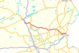
Pennsylvania Route 248 is a 31.11 mi (50.1 km) long state highway
in eastern portions of the U.S. state
of Pennsylvania
. The western terminus of the route is at U.S. Route 209 in Weissport
. The eastern terminus is at Pennsylvania Route 611
in Easton
.
The highway was originally signed as Pennsylvania Route 45
from 1927 to 1966.
in Weissport
, where it continues as Canal Street. The highway begins as a four-lane divided highway
along the eastern banks of the Lehigh River
running on a southern direction. In Parryville
, PA 248 has a grade level
exit signed as "Parryville" south of the Interstate 476
(Pennsylvania Turnpike
) underpass. Southeast of the borough, PA 248 becomes a limited-access road and interchanges the eastern terminus of Pennsylvania Route 895
in Bowmanstown. After PA 895, PA 248 has a more eastward alignment, before the exit to the borough of Palmerton
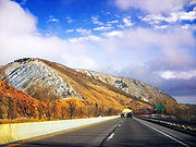
via Delaware Avenue. South of the Palmerton exit, the expressway ends in Lehigh Gap
, where the Blue Mountain
ridge is located. In the hamlet of Weiders Crossing, the route intersects the northern termini of Pennsylvania Route 873
and Pennsylvania Route 145
before proceeding on a southeast direction to become Lehigh Drive.
In Lehigh Township
, PA 248 travels to the southeast and encounters the western terminus of Pennsylvania Route 946
. In the village of Cherryville, the route meets Blue Mountain Drive, which provides access to Blue Mountain Ski Area
. PA 248 enters Bath
from the west as Main Street, then it has a fairly short concurrency with Pennsylvania Route 987
at the eastern terminus of Pennsylvania Route 329
.
 East of Bath, PA 248 is marked as the Bath Pike. In Upper Nazareth Township
, the highway intersects Pennsylvania Route 946
. In Nazareth
, PA 248 is known as Easton Road and has a small overlap with Pennsylvania Route 191
. Outside of Nazareth, Route 248 is called Easton-Nazareth Highway running to the southeast. The highway interchanges Pennsylvania Route 33
in Lower Nazareth Township
and it is called Nazareth Road east of PA 33.
In Wilson
, PA 248 interchanges U.S. Route 22 while turning east onto Northampton Street. Motorists can access US 22 eastbound via 25th Street. East of 15th Street, the route has entered the city of Easton
. Northampton Street is the main commercial route in Easton with attractions like the State Theater. Route 248 makes a 90 degree-angle turn onto 7th Street, then turns to the northeast to be named Prospect Ave. Then it turns to the east to become Pearl Street, which intersects and becomes Bushkill Street. While named Bushkill Street, the route is parallel to U.S. Route 22
. It turns to the south to become Larry Holmes Drive and then terminates at an intersection with Pennsylvania Route 611
.
in North Central Pennsylvania
extended to Hometown. The route was designated from what is now PA 873 (former US 309) in Lehigh Gap to US 22, at the intersection of Northampton Street and Walnut Avenue in Easton.
PA 248 was also designated onto a small portion of the William Penn Highway
; from the intersection of Walnut and Northampton (PA 45) to the New Jersey
state line at the Northampton Street Bridge
, it was first designated onto the easternmost segment of PA 3, between 1924 and 1930, then US 22 from 1926 to 1955. In 1955, US 22 was moved north to the Lehigh Valley Thruway
; In the 1960s, this led PA 45 to replace the previous US 22 designation. In 1966, PA 248 was established from Lehigh Gap to Easton.
in Weissport. From the 1960s to the 1970s, Pennsylvania Route 29
succeeded US 309. Construction began in 1963 on the expressway between Lehigh Gap and Parryville; By 1970, the entire Weissport-Lehigh Gap segment was designated as PA 248.
State highway
State highway, state road or state route can refer to one of three related concepts, two of them related to a state or provincial government in a country that is divided into states or provinces :#A...
in eastern portions of the U.S. state
U.S. state
A U.S. state is any one of the 50 federated states of the United States of America that share sovereignty with the federal government. Because of this shared sovereignty, an American is a citizen both of the federal entity and of his or her state of domicile. Four states use the official title of...
of Pennsylvania
Pennsylvania
The Commonwealth of Pennsylvania is a U.S. state that is located in the Northeastern and Mid-Atlantic regions of the United States. The state borders Delaware and Maryland to the south, West Virginia to the southwest, Ohio to the west, New York and Ontario, Canada, to the north, and New Jersey to...
. The western terminus of the route is at U.S. Route 209 in Weissport
Weissport, Pennsylvania
Weissport is a borough in Carbon County, Pennsylvania, United States. The town was founded in 1792 by Col. Jacob Weiss. This particular area was located between Lehighton, Parryville and Longrun. Soon after the town itself was established, and the first wooden bridge over the river to the town...
. The eastern terminus is at Pennsylvania Route 611
Pennsylvania Route 611
Pennsylvania Route 611 is a major state highway in Pennsylvania, United States, running from Interstate 95 south of downtown Philadelphia north to Interstate 380 in Coolbaugh Township, Pennsylvania in The Poconos....
in Easton
Easton, Pennsylvania
Easton is a city in Northampton County, Pennsylvania, United States. The population was 26,800 as of the 2010 census. It is the county seat of Northampton County....
.
The highway was originally signed as Pennsylvania Route 45
Pennsylvania Route 45
Pennsylvania Route 45 or State Route 45 is an long state highway located in central Pennsylvania. PA 45 is called the Purple Heart Highway.The western terminus of the route is at Pennsylvania Route 453 in the Morris Township near the community of Water Street...
from 1927 to 1966.
Weissport to Bath
PA 248 begins at an intersection with U.S. Route 209U.S. Route 209
U.S. Route 209 is a long U.S. highway in the states of Pennsylvania and New York. Although the route is a spur of U.S. Route 9, US 209 never intersects US 9, making the connection via U.S. Route 9W instead. The southern terminus of the route is at Pennsylvania...
in Weissport
Weissport, Pennsylvania
Weissport is a borough in Carbon County, Pennsylvania, United States. The town was founded in 1792 by Col. Jacob Weiss. This particular area was located between Lehighton, Parryville and Longrun. Soon after the town itself was established, and the first wooden bridge over the river to the town...
, where it continues as Canal Street. The highway begins as a four-lane divided highway
Divided Highway
Divided Highway is a compilation album by American rock band The Doobie Brothers, released in 2003. . All tracks are taken from the albums Cycles and Brotherhood .-Track listing:...
along the eastern banks of the Lehigh River
Lehigh River
The Lehigh River, a tributary of the Delaware River, is a river located in eastern Pennsylvania, in the United States. Part of the Lehigh, along with a number of its tributaries, is designated a Pennsylvania Scenic River by the state's Department of Conservation and Natural Resources...
running on a southern direction. In Parryville
Parryville, Pennsylvania
Parryville is a borough in Carbon County, Pennsylvania, United States. The population was 478 at the 2000 census. Parryville is located southeast of Lehighton and north of Bowmanstown off Route 248 and northwest of Palmerton...
, PA 248 has a grade level
At-grade intersection
An at-grade intersection is a junction at which two or more transport axes cross at the same level .-Traffic management:With areas of high or fast traffic, an at-grade intersection normally requires a traffic control device such as a stop sign, traffic light or railway signal to manage conflicting...
exit signed as "Parryville" south of the Interstate 476
Interstate 476
Interstate 476 is a auxiliary Interstate Highway in the U.S. state of Pennsylvania designated between Interstate 95 near Chester and Interstate 81 near Scranton, serving as the primary north–south Interstate corridor through eastern Pennsylvania....
(Pennsylvania Turnpike
Pennsylvania Turnpike
The Pennsylvania Turnpike is a toll highway system operated by the Pennsylvania Turnpike Commission in the Commonwealth of Pennsylvania, United States. The three sections of the turnpike system total . The main section extends from Ohio to New Jersey and is long...
) underpass. Southeast of the borough, PA 248 becomes a limited-access road and interchanges the eastern terminus of Pennsylvania Route 895
Pennsylvania Route 895
Pennsylvania Route 895 is a state highway in the U.S. state of Pennsylvania. It is designated as an east–west route, with termini at Route 443 in Pine Grove and Route 248 in Bowmanstown. The entire course is close to the north flank of Blue Mountain.- Schuylkill County :PA 895 begins at an...
in Bowmanstown. After PA 895, PA 248 has a more eastward alignment, before the exit to the borough of Palmerton
Palmerton, Pennsylvania
Palmerton is a borough in Carbon County, Pennsylvania, United States. It is located in the coal region of the state. It is a part of lower Carbon County, which is considered part of the Lehigh Valley and the greater Allentown Metropolitan Area....
via Delaware Avenue. South of the Palmerton exit, the expressway ends in Lehigh Gap
Lehigh Gap, Pennsylvania
The Lehigh Gap, located in Lower Towamensing Township, Carbon County, Pennsylvania, is a water gap formed by the Lehigh River where it cuts through Blue Mountain in the state of Pennsylvania in the United States. The gap allows easy travel between Carbon County to the north and Lehigh and...
, where the Blue Mountain
Blue Mountain (Pennsylvania)
Blue Mountain is a ridge that forms the eastern edge of the Appalachian mountain range in the U.S. state of Pennsylvania. It cuts across the eastern half of the state from New Jersey to Maryland, providing a distinct boundary between a number of Pennsylvania's geographical and cultural regions...
ridge is located. In the hamlet of Weiders Crossing, the route intersects the northern termini of Pennsylvania Route 873
Pennsylvania Route 873
Pennsylvania Route 873 is a north-south, two-lane road mainly located in northern Lehigh County, Pennsylvania. Its northern terminus is at PA 248 in the Lehigh Township hamlet of Weiders Crossing. It passes through Slatington as Main Street. Its southern terminus is at PA 309 in Schnecksville....
and Pennsylvania Route 145
Pennsylvania Route 145
Pennsylvania Route 145 , unofficially known as "the gateway to Allentown", is a long north–south state highway in the Lehigh Valley area of eastern Pennsylvania...
before proceeding on a southeast direction to become Lehigh Drive.
In Lehigh Township
Lehigh Township, Northampton County, Pennsylvania
Lehigh Township is a township in Northampton County, Pennsylvania, United States. Lehigh Township is located in the Lehigh Valley region of the state.The population of Lehigh Township was 9,728 at the 2000 census.-Geography:...
, PA 248 travels to the southeast and encounters the western terminus of Pennsylvania Route 946
Pennsylvania Route 946
Pennsylvania Route 946 is a rural Pennsylvania highway that runs approximately from Berlinsville, Pennsylvania to Newburg, Pennsylvania in Northampton County, Pennsylvania.-Route description:...
. In the village of Cherryville, the route meets Blue Mountain Drive, which provides access to Blue Mountain Ski Area
Blue Mountain Ski Area
Blue Mountain is a ski resort located near Palmerton, Pennsylvania, on Blue Mountain in the northern part of the Lehigh Valley, in Pennsylvania...
. PA 248 enters Bath
Bath, Pennsylvania
Bath is a borough in Northampton County, Pennsylvania, United States. It is named for Bath, Somerset, England. It is located in the Lehigh Valley region of the state.The population of Bath was 2,693 at the 2010 census.-History:...
from the west as Main Street, then it has a fairly short concurrency with Pennsylvania Route 987
Pennsylvania Route 987
Pennsylvania Route 987 is a state highway in the U.S. state of Pennsylvania, running north from U.S. Route 22 past Lehigh Valley International Airport to Pennsylvania Route 946.-Route description:...
at the eastern terminus of Pennsylvania Route 329
Pennsylvania Route 329
Pennsylvania Route 329 is a Pennsylvania highway which runs for through Lehigh and Northampton counties. It runs from Bath, Pennsylvania to the North Whitehall Township hamlet of Neffs.-Lehigh County:...
.
Bath to Easton
Upper Nazareth Township, Pennsylvania
Upper Nazareth Township is a township in Northampton County, Pennsylvania, United States. Upper Nazareth Township is located in the Lehigh Valley region of the state.The population of Upper Nazareth Township was 4,426 at the 2000 census....
, the highway intersects Pennsylvania Route 946
Pennsylvania Route 946
Pennsylvania Route 946 is a rural Pennsylvania highway that runs approximately from Berlinsville, Pennsylvania to Newburg, Pennsylvania in Northampton County, Pennsylvania.-Route description:...
. In Nazareth
Nazareth, Pennsylvania
Nazareth is a borough in Northampton County, Pennsylvania, in the United States. The population was 6,023 at the 2000 census.Nazareth is located seven miles northwest of Easton, four miles north of Bethlehem and twelve miles northeast of Allentown...
, PA 248 is known as Easton Road and has a small overlap with Pennsylvania Route 191
Pennsylvania Route 191
Pennsylvania Route 191 is a -long state highway in the U.S. state of Pennsylvania. The route, a major non-freeway corridor connecting the Lehigh Valley to The Poconos in eastern Pennsylvania, is designated from U.S...
. Outside of Nazareth, Route 248 is called Easton-Nazareth Highway running to the southeast. The highway interchanges Pennsylvania Route 33
Pennsylvania Route 33
Pennsylvania Route 33 is a -long limited-access state highway in eastern Pennsylvania, United States. South of the US 22 interchange, the route is called the Gen. Anthony Clement McAuliffe 101st Airborne Memorial Highway....
in Lower Nazareth Township
Lower Nazareth Township, Pennsylvania
Lower Nazareth Township is a township in Northampton County, Pennsylvania, United States. Lower Nazareth Township is located in the Lehigh Valley region of the state.The population of Lower Nazareth Township was 5,259 at the 2000 census.-Geography:...
and it is called Nazareth Road east of PA 33.
In Wilson
Wilson, Pennsylvania
Wilson is a borough in Northampton County, Pennsylvania, United States. It is part of Pennsylvania's Lehigh Valley region, and is adjacent to Easton, the smallest and easternmost of the Lehigh Valley's three cities....
, PA 248 interchanges U.S. Route 22 while turning east onto Northampton Street. Motorists can access US 22 eastbound via 25th Street. East of 15th Street, the route has entered the city of Easton
Easton, Pennsylvania
Easton is a city in Northampton County, Pennsylvania, United States. The population was 26,800 as of the 2010 census. It is the county seat of Northampton County....
. Northampton Street is the main commercial route in Easton with attractions like the State Theater. Route 248 makes a 90 degree-angle turn onto 7th Street, then turns to the northeast to be named Prospect Ave. Then it turns to the east to become Pearl Street, which intersects and becomes Bushkill Street. While named Bushkill Street, the route is parallel to U.S. Route 22
Lehigh Valley Thruway
U.S. Route 22 is an east–west route stretching from Cincinnati, Ohio in the west to Newark, New Jersey in the east. In Pennsylvania, the route runs for between the West Virginia state line at Washington County, where it is a limited-access expressway-grade route through the western suburbs...
. It turns to the south to become Larry Holmes Drive and then terminates at an intersection with Pennsylvania Route 611
Pennsylvania Route 611
Pennsylvania Route 611 is a major state highway in Pennsylvania, United States, running from Interstate 95 south of downtown Philadelphia north to Interstate 380 in Coolbaugh Township, Pennsylvania in The Poconos....
.
Lehigh Gap to Easton
In the original 1927 numbering, the highway was designated as one of the two segments of Pennsylvania Route 45, the other segment being the current numbering of the routePennsylvania Route 45
Pennsylvania Route 45 or State Route 45 is an long state highway located in central Pennsylvania. PA 45 is called the Purple Heart Highway.The western terminus of the route is at Pennsylvania Route 453 in the Morris Township near the community of Water Street...
in North Central Pennsylvania
Pennsylvania
The Commonwealth of Pennsylvania is a U.S. state that is located in the Northeastern and Mid-Atlantic regions of the United States. The state borders Delaware and Maryland to the south, West Virginia to the southwest, Ohio to the west, New York and Ontario, Canada, to the north, and New Jersey to...
extended to Hometown. The route was designated from what is now PA 873 (former US 309) in Lehigh Gap to US 22, at the intersection of Northampton Street and Walnut Avenue in Easton.
PA 248 was also designated onto a small portion of the William Penn Highway
William Penn Highway
The William Penn Highway was an auto trail in the United States, generally running from Pittsburgh east to New York City. It served as the eastern end of the Pikes Peak Ocean-to-Ocean Highway. The William Penn Highway Association of Pennsylvania was organized March 27, 1916 to promote a road...
; from the intersection of Walnut and Northampton (PA 45) to the New Jersey
New Jersey
New Jersey is a state in the Northeastern and Middle Atlantic regions of the United States. , its population was 8,791,894. It is bordered on the north and east by the state of New York, on the southeast and south by the Atlantic Ocean, on the west by Pennsylvania and on the southwest by Delaware...
state line at the Northampton Street Bridge
Northampton Street Bridge
The Northampton Street Bridge is a bridge connecting Easton, PA and Phillipsburg, NJ that crosses the Delaware River. It is maintained by the Delaware River Joint Toll Bridge Commission despite not being a toll bridge. It is known locally as the "Free Bridge" thus distinguishing it from the...
, it was first designated onto the easternmost segment of PA 3, between 1924 and 1930, then US 22 from 1926 to 1955. In 1955, US 22 was moved north to the Lehigh Valley Thruway
Lehigh Valley Thruway
U.S. Route 22 is an east–west route stretching from Cincinnati, Ohio in the west to Newark, New Jersey in the east. In Pennsylvania, the route runs for between the West Virginia state line at Washington County, where it is a limited-access expressway-grade route through the western suburbs...
; In the 1960s, this led PA 45 to replace the previous US 22 designation. In 1966, PA 248 was established from Lehigh Gap to Easton.
Weissport to Lehigh Gap
From 1926 to the late 1950s, PA 248 was designated as U.S. Route 309 which ran from what is now PA 248 (former PA 45) in Lehigh Gap to U.S. Route 209U.S. Route 209
U.S. Route 209 is a long U.S. highway in the states of Pennsylvania and New York. Although the route is a spur of U.S. Route 9, US 209 never intersects US 9, making the connection via U.S. Route 9W instead. The southern terminus of the route is at Pennsylvania...
in Weissport. From the 1960s to the 1970s, Pennsylvania Route 29
Pennsylvania Route 29
Pennsylvania Route 29 is a 118 mile long north–south state highway that runs through most of eastern Pennsylvania. The route currently exists in two segments, a southern segment and a northern segment. The southernmost terminus of the designation is at U.S. Route 30 in Malvern...
succeeded US 309. Construction began in 1963 on the expressway between Lehigh Gap and Parryville; By 1970, the entire Weissport-Lehigh Gap segment was designated as PA 248.