

Lehigh Gap, Pennsylvania
Encyclopedia
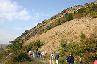
Water gap
A water gap is an opening or notch which flowing water has carved through a mountain range. Water gaps often offer a practical route for road and rail transport to cross mountain ridges.- Geology :...
formed by the Lehigh River
Lehigh River
The Lehigh River, a tributary of the Delaware River, is a river located in eastern Pennsylvania, in the United States. Part of the Lehigh, along with a number of its tributaries, is designated a Pennsylvania Scenic River by the state's Department of Conservation and Natural Resources...
where it cuts through Blue Mountain
Blue Mountain (Pennsylvania)
Blue Mountain is a ridge that forms the eastern edge of the Appalachian mountain range in the U.S. state of Pennsylvania. It cuts across the eastern half of the state from New Jersey to Maryland, providing a distinct boundary between a number of Pennsylvania's geographical and cultural regions...
in the state of Pennsylvania
Pennsylvania
The Commonwealth of Pennsylvania is a U.S. state that is located in the Northeastern and Mid-Atlantic regions of the United States. The state borders Delaware and Maryland to the south, West Virginia to the southwest, Ohio to the west, New York and Ontario, Canada, to the north, and New Jersey to...
in the United States
United States
The United States of America is a federal constitutional republic comprising fifty states and a federal district...
. The gap allows easy travel between Carbon County
Carbon County, Pennsylvania
As of the census of 2000, there were 58,802 people, 23,701 households, and 16,424 families residing in the county. The population density was 154 people per square mile . There were 30,492 housing units at an average density of 80 per square mile...
to the north and Lehigh
Lehigh County, Pennsylvania
-Climate:Most of the county's climate is considered to fall in the humid continental climate zone. Summers are typically hot and muggy, fall and spring are generally mild, and winter is cold. Precipitation is almost uniformly distributed throughout the year....
and Northampton
Northampton County, Pennsylvania
As of the 2010 census, the county was 86.3% White, 5.0% Black or African American, 0.2% Native American or Alaskan Native, 2.4% Asian, 0.0% Native Hawaiian, 2.2% were two or more races, and 3.8% were some other race. 10.5% of the population were of Hispanic or Latino ancestry.As of the census of...
counties to the south of the mountain. One of the more distinctive features of the gap is Devil's Pulpit, a rock formation that reminds hikers of a pulpit
Pulpit
Pulpit is a speakers' stand in a church. In many Christian churches, there are two speakers' stands at the front of the church. Typically, the one on the left is called the pulpit...
. Lehigh Gap is also the name of a village also known as Weider's Crossing and located at the south end of the gap in Lehigh and Northampton Counties.
Travel
Pennsylvania Route 248Pennsylvania Route 248
Pennsylvania Route 248 is a long state highway in eastern portions of the U.S. state of Pennsylvania. The western terminus of the route is at U.S. Route 209 in Weissport. The eastern terminus is at Pennsylvania Route 611 in Easton....
runs directly through the gap, connecting the Lehigh Valley
Lehigh Valley
The Lehigh Valley, known officially by the United States Census Bureau as the Allentown-Bethlehem-Easton, PA-NJ metropolitan area and referred to locally as The Valley and A-B-E, is a metropolitan region consisting of Lehigh, Northampton, Berks, and Carbon counties in eastern Pennsylvania and...
metro area to the smaller Carbon County boroughs of Palmerton
Palmerton, Pennsylvania
Palmerton is a borough in Carbon County, Pennsylvania, United States. It is located in the coal region of the state. It is a part of lower Carbon County, which is considered part of the Lehigh Valley and the greater Allentown Metropolitan Area....
, Bowmanstown
Bowmanstown, Pennsylvania
Bowmanstown is a borough in Carbon County, Pennsylvania, United States. The population was 895 at the 2000 census. Bowmanstown is at an elevation of and is located west of Palmerton and south of Lehighton off of Route 248.-Geography:...
and Lehighton
Lehighton, Pennsylvania
Lehighton is a borough in Carbon County, Pennsylvania, north by west of Philadelphia. In the past, it developed early industries because of water power from the Lehigh River. With the location of a repair facility here and its regional operations, the Lehigh Valley Railroad became for years a...
. State Routes 873
Pennsylvania Route 873
Pennsylvania Route 873 is a north-south, two-lane road mainly located in northern Lehigh County, Pennsylvania. Its northern terminus is at PA 248 in the Lehigh Township hamlet of Weiders Crossing. It passes through Slatington as Main Street. Its southern terminus is at PA 309 in Schnecksville....
and 145
Pennsylvania Route 145
Pennsylvania Route 145 , unofficially known as "the gateway to Allentown", is a long north–south state highway in the Lehigh Valley area of eastern Pennsylvania...
connect to Route 248
Pennsylvania Route 248
Pennsylvania Route 248 is a long state highway in eastern portions of the U.S. state of Pennsylvania. The western terminus of the route is at U.S. Route 209 in Weissport. The eastern terminus is at Pennsylvania Route 611 in Easton....
just south of the gap.
Besides vehicular travel, the gap also provides a crossing through the mountain for hikers on the Appalachian Trail
Appalachian Trail
The Appalachian National Scenic Trail, generally known as the Appalachian Trail or simply the AT, is a marked hiking trail in the eastern United States extending between Springer Mountain in Georgia and Mount Katahdin in Maine. It is approximately long...
. The Delaware and Lehigh Heritage Corridor Trail also intersects Lehigh Gap.
Railroads
Three railroad companies once had trackage through the Lehigh Gap. The Lehigh & New England Railroad used to have a bridge crossing the Lehigh River within the gap. The bridge was abandoned in 1961, but its foundations on each side of the river are still visible as are telegraph poles. The bridge was torn down in 1967.The Lehigh Valley Railroad
Lehigh Valley Railroad
The Lehigh Valley Railroad was one of a number of railroads built in the northeastern United States primarily to haul anthracite coal.It was authorized April 21, 1846 in the U.S. state of Pennsylvania and incorporated September 20, 1847 as the Delaware, Lehigh, Schuylkill and Susquehanna Railroad...
had its mainline on the south side of the Lehigh River. It was abandoned and removed by Conrail in 1984.
The Central Railroad of New Jersey
Central Railroad of New Jersey
The Central Railroad of New Jersey , commonly known as the Jersey Central Lines or CNJ, was a Class I railroad with origins in the 1830s, lasting until 1976 when it was absorbed into Conrail with the other bankrupt railroads of the Northeastern United States...
had its mainline on the north side of the Lehigh River. It is currently owned by Norfolk Southern Railway
Norfolk Southern Railway
The Norfolk Southern Railway is a Class I railroad in the United States, owned by the Norfolk Southern Corporation. With headquarters in Norfolk, Virginia, the company operates 21,500 route miles in 22 eastern states, the District of Columbia and the province of Ontario, Canada...
and also used by Canadian Pacific Railway
Canadian Pacific Railway
The Canadian Pacific Railway , formerly also known as CP Rail between 1968 and 1996, is a historic Canadian Class I railway founded in 1881 and now operated by Canadian Pacific Railway Limited, which began operations as legal owner in a corporate restructuring in 2001...
.
Lehigh Gap Nature Center
In 2002, the Wildlife Information Center, since renamed the Lehigh Gap Nature Center, purchased more than 750 acres (3 km²) near Lehigh Gap. Their goal is to restore the wildlife along Blue Mountain. From 1898 to 1980, the Palmerton Zinc plant emitted sulfur dioxide at rates of up to 3,600 pounds per hour, killing plant life and animal habitats. Twenty years later, a noticeable lack of tree density remains on the Palmerton side of the gap.The Lehigh Gap Nature Center currently includes The Osprey House on the Slatington
Slatington, Pennsylvania
Slatington is a borough in Lehigh County, Pennsylvania. It is located 15 miles northwest of Allentown, in the Lehigh Valley region of the state...
side of the river. The nature center works closely with colleges and universities on various wildlife-oriented research projects. The center also sponsors a club for young naturalists. The nature center is home to several miles of hiking trails, open to the public from dawn to dusk.