
Pennsylvania Route 33
Overview
State highway
State highway, state road or state route can refer to one of three related concepts, two of them related to a state or provincial government in a country that is divided into states or provinces :#A...
in eastern Pennsylvania
Pennsylvania
The Commonwealth of Pennsylvania is a U.S. state that is located in the Northeastern and Mid-Atlantic regions of the United States. The state borders Delaware and Maryland to the south, West Virginia to the southwest, Ohio to the west, New York and Ontario, Canada, to the north, and New Jersey to...
, United States
United States
The United States of America is a federal constitutional republic comprising fifty states and a federal district...
. South of the US 22 interchange, the route is called the Gen. Anthony Clement McAuliffe
Anthony McAuliffe
General Anthony Clement "Nuts" McAuliffe was the United States Army general who commanded the 101st Airborne Division troops defending Bastogne, Belgium during the Battle of the Bulge in World War II...
101st Airborne Memorial Highway.
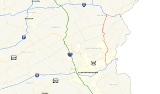
The northern terminus is Interstate 80
Interstate 80
Interstate 80 is the second-longest Interstate Highway in the United States, following Interstate 90. It is a transcontinental artery running from downtown San Francisco, California to Teaneck, New Jersey in the New York City Metropolitan Area...
near Stroudsburg
Stroudsburg, Pennsylvania
Stroudsburg is a borough in Monroe County, Pennsylvania, United States. It is located in the Poconos region of the state, approximately five miles from the Delaware Water Gap, at the confluence of the Brodhead and Pocono Creeks. It is the county seat of Monroe County. Stroudsburg is part of the...
and the southern terminus is Interstate 78
Interstate 78
Interstate 78 is an Interstate Highway in the Northeast United States, running 144 miles from Interstate 81 northeast of Harrisburg, Pennsylvania, through Allentown, Pennsylvania, and western and northern New Jersey to the Holland Tunnel and Lower Manhattan in New York City.I-78 is a major road...
in southern Northampton County
Northampton County, Pennsylvania
As of the 2010 census, the county was 86.3% White, 5.0% Black or African American, 0.2% Native American or Alaskan Native, 2.4% Asian, 0.0% Native Hawaiian, 2.2% were two or more races, and 3.8% were some other race. 10.5% of the population were of Hispanic or Latino ancestry.As of the census of...
. Until 2003, the southern terminus was U.S. Route 22. It is commonly used as a hazmat bypass for the Pennsylvania Turnpike
Pennsylvania Turnpike
The Pennsylvania Turnpike is a toll highway system operated by the Pennsylvania Turnpike Commission in the Commonwealth of Pennsylvania, United States. The three sections of the turnpike system total . The main section extends from Ohio to New Jersey and is long...
's Northeast Extension
Interstate 476
Interstate 476 is a auxiliary Interstate Highway in the U.S. state of Pennsylvania designated between Interstate 95 near Chester and Interstate 81 near Scranton, serving as the primary north–south Interstate corridor through eastern Pennsylvania....
due to the restrictions in place on the Lehigh Tunnel
Lehigh Tunnel
The Lehigh Tunnel is a pair of road tunnels that carries the Pennsylvania Turnpike Northeast Extension under the Blue Mountain north from Interstate 78 to the Scranton/Wilkes-Barre area between mileposts 70.7 to 71.5. The tunnel was called the Lehigh Tunnel to avoid confusion with the existing...
.
PA 33 begins at a trumpet interchange with Interstate 78 in southern Northampton County.