
Paya Lebar
Encyclopedia
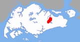
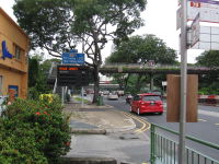
Paya Lebar is an area in the north-eastern part of Singapore
. It is served by Paya Lebar Station
, on the East West Line
of Singapore's Mass Rapid Transit
system. It is an urban planning area
. The Singapore Post Centre is located there too.

y area close to the Kallang River
, hence its name. Paya means "swamp" and lebar means "wide" in Malay
. This was an extensive and notorious squatter district, whose inhabitants engage in cultivating market
produce, including pig
and poultry
rearing.
One of the first persons to colonise this area was Richard Owen Norris (died 1905), who bought part of the area in 1865 and lived here with his family.
The admiralty wireless station
was in this district in 1915.
In 1955, Singapore International Airport (commonly referred to as "Paya Lebar Airport") was opened and became the area's chief landmark
, along with a number of housing estates, schools and factories.
Paya Lebar Street was officially named in 1958, while Paya Lebar Way was named in 1972.
Singapore
Singapore , officially the Republic of Singapore, is a Southeast Asian city-state off the southern tip of the Malay Peninsula, north of the equator. An island country made up of 63 islands, it is separated from Malaysia by the Straits of Johor to its north and from Indonesia's Riau Islands by the...
. It is served by Paya Lebar Station
Paya Lebar MRT Station
Paya Lebar MRT Station is a Mass Rapid Transit interchange station on the East West Line and the Circle Line in Singapore. It is the first station complex in Singapore that serves both an above ground line and an underground line . The livery of the East West Line and the Circle Line portions...
, on the East West Line
East West MRT Line
The East West Line was the 2nd Mass Rapid Transit line in Singapore. The line is currently 49.2 km long with 35 stations , making it the longest MRT line in Singapore. It takes about 63 minutes to travel from one end to the other...
of Singapore's Mass Rapid Transit
Mass Rapid Transit (Singapore)
The Mass Rapid Transit or MRT is a rapid transit system that forms the backbone of the railway system in Singapore, spanning the entire city-state. The initial section of the MRT, between Yio Chu Kang Station and Toa Payoh Station, opened in 1987 establishing itself as the second-oldest metro...
system. It is an urban planning area
Urban planning areas in Singapore
Singapore is currently divided into 55 urban planning areas by the Urban Redevelopment Authority, organised into five regions. A Development Guide Plan is then drawn up for each planning area, providing for detailed planning guidelines for every individual plot of land throughout the country.The...
. The Singapore Post Centre is located there too.
Etymology and history
Paya Lebar was a large, swampSwamp
A swamp is a wetland with some flooding of large areas of land by shallow bodies of water. A swamp generally has a large number of hammocks, or dry-land protrusions, covered by aquatic vegetation, or vegetation that tolerates periodical inundation. The two main types of swamp are "true" or swamp...
y area close to the Kallang River
Kallang River
The Kallang River flows for 10 kilometres from the Lower Peirce Reservoir to the coast at Nicoll Highway, making it the longest river in Singapore...
, hence its name. Paya means "swamp" and lebar means "wide" in Malay
Malay language
Malay is a major language of the Austronesian family. It is the official language of Malaysia , Indonesia , Brunei and Singapore...
. This was an extensive and notorious squatter district, whose inhabitants engage in cultivating market
Market
A market is one of many varieties of systems, institutions, procedures, social relations and infrastructures whereby parties engage in exchange. While parties may exchange goods and services by barter, most markets rely on sellers offering their goods or services in exchange for money from buyers...
produce, including pig
Pig
A pig is any of the animals in the genus Sus, within the Suidae family of even-toed ungulates. Pigs include the domestic pig, its ancestor the wild boar, and several other wild relatives...
and poultry
Poultry
Poultry are domesticated birds kept by humans for the purpose of producing eggs, meat, and/or feathers. These most typically are members of the superorder Galloanserae , especially the order Galliformes and the family Anatidae , commonly known as "waterfowl"...
rearing.
One of the first persons to colonise this area was Richard Owen Norris (died 1905), who bought part of the area in 1865 and lived here with his family.
The admiralty wireless station
Base station
The term base station can be used in the context of land surveying and wireless communications.- Land surveying :In the context of external land surveying, a base station is a GPS receiver at an accurately-known fixed location which is used to derive correction information for nearby portable GPS...
was in this district in 1915.
In 1955, Singapore International Airport (commonly referred to as "Paya Lebar Airport") was opened and became the area's chief landmark
Landmark
This is a list of landmarks around the world.Landmarks may be split into two categories - natural phenomena and man-made features, like buildings, bridges, statues, public squares and so forth...
, along with a number of housing estates, schools and factories.
Paya Lebar Street was officially named in 1958, while Paya Lebar Way was named in 1972.