
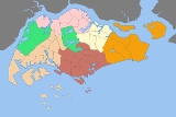
Urban planning areas in Singapore
Overview
Singapore
Singapore , officially the Republic of Singapore, is a Southeast Asian city-state off the southern tip of the Malay Peninsula, north of the equator. An island country made up of 63 islands, it is separated from Malaysia by the Straits of Johor to its north and from Indonesia's Riau Islands by the...
is currently divided into 55 urban planning areas by the Urban Redevelopment Authority
Urban Redevelopment Authority
The Urban Redevelopment Authority is the national urban planning authority of Singapore, and a statutory board under the Ministry of National Development of the Singapore Government.-Mission:The authority was established on 1 April 1974, and is of especially critical importance to the city-state,...
, organised into five regions
Regions of Singapore
The regions of Singapore are urban planning subdivisions demarcated by the Urban Redevelopment Authority of Singapore to aid in its planning efforts. Over time, however, these 5 regions have also been adopted by other governmental organizations in their administrative work, such as their usage in...
.http://www.ura.gov.sg/landuse/devtguide.htm A Development Guide Plan
Development Guide Plan
A Development Guide Plan is a detailed urban land use plan for each of the 55 areas in Singapore designated by the Urban Redevelopment Authority , Singapore's national planning and conservation authority.-History:...
is then drawn up for each planning area, providing for detailed planning guidelines for every individual plot of land throughout the country.
The URA's planning areas were first introduced in the early 1990s after the release of the 1991 Concept Plan.http://www.ura.gov.sg/dgp_reports/angmokio/main.html Since the implementation of these boundaries, other governmental ministries and departments have also increasingly adopted these boundaries for their administrative purposes.