

Pathhead, Midlothian
Encyclopedia
Midlothian
Midlothian is one of the 32 council areas of Scotland, and a lieutenancy area. It borders the Scottish Borders, East Lothian and the City of Edinburgh council areas....
, Scotland
Scotland
Scotland is a country that is part of the United Kingdom. Occupying the northern third of the island of Great Britain, it shares a border with England to the south and is bounded by the North Sea to the east, the Atlantic Ocean to the north and west, and the North Channel and Irish Sea to the...
.
Location
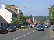
Pathhead is located around 4 miles (6.4 km) south east of DalkeithDalkeith
Dalkeith is a town in Midlothian, Scotland, lying on the River North Esk. It was granted a burgh of barony in 1401 and a burgh of regality in 1540...
and 11 miles (17.7 km) south of Scotland's capital city, Edinburgh
Edinburgh
Edinburgh is the capital city of Scotland, the second largest city in Scotland, and the eighth most populous in the United Kingdom. The City of Edinburgh Council governs one of Scotland's 32 local government council areas. The council area includes urban Edinburgh and a rural area...
. It lies above the east bank of the River Tyne
River Tyne, Scotland
The River Tyne is a river in Scotland, UK. It rises in the Moorfoot Hills in Midlothian near Tynehead to the south of Edinburgh, at the junction of the B6458 and the B6367. It continues for approx...
. The name of the village is due to its position. It stands 500 feet (152.4 m) above sea level and is at the head of the ascent of the main route from Edinburgh to Lauder
Lauder
The Royal Burgh of Lauder is a town in the Scottish Borders 27 miles south east of Edinburgh. It is also a royal burgh in the county of Berwickshire. It lies on the edge of the Lammermuir Hills, on the Southern Upland Way.-Medieval history:...
. The A68 road
A68 road
The A68 is a major road in the United Kingdom, running from Darlington in England to the A720 in Scotland.From Darlington, the road runs north, bypassing Bishop Auckland, and running through West Auckland, Toft Hill and Tow Law, past Consett and Corbridge...
(part of the European route E15
European route E15
The European route E 15 is part of the United Nations international E-road network. It is a north-south "reference road", running from Inverness, Scotland south through England and France to Algeciras, Spain...
) is now the main route through the village. With the opening of the Dalkeith bypass in 2008, it is possible to travel to Edinburgh in 10–15 minutes.
Historic buildings
A five-arch stone bridge carries the A68 road over the Tyne Water at the north west entrance to the village. The bridge is 80 feet (24.4 m) high, and each of the five spans is 50 feet (15.2 m) across. It was built in 1827–1831 to the designs of engineer Thomas TelfordThomas Telford
Thomas Telford FRS, FRSE was a Scottish civil engineer, architect and stonemason, and a noted road, bridge and canal builder.-Early career:...
, and is a Category A listed building.
To the north of the village is Preston Hall
Preston Hall, Midlothian
Preston Hall, or Prestonhall, is a late-18th-century mansion in Midlothian, to the south of Edinburgh, Scotland. It is located north of Pathhead on the east side of the Tyne Water, opposite Oxenfoord Castle on the west side. The house, together with several estate buildings, are the work of...
, an 18th-century country house designed by William Adam for the Duchess of Gordon
Duke of Gordon
The title Duke of Gordon has been created once in the Peerage of Scotland and again in the Peerage of the United Kingdom.The Dukedom, named after the Clan Gordon, was first created for the 4th Marquess of Huntly, who on 3 November 1684 was created Duke of Gordon, Marquess of Huntly, Earl of Huntly...
, and later rebuilt by Robert Mitchell for Alexander Callander, whose descendants still occupy the house. On the opposite side of the Tyne Water is Oxenfoord Castle
Oxenfoord Castle
Oxenfoord Castle is a country house in Midlothian, Scotland. It is located north of Pathhead, and south-east of Dalkeith, above the Tyne Water. Originally a 16th-century tower house, the present castle is largely the result of major rebuilding in 1782, to designs by the architect Robert Adam....
, originally a 16th-century tower house belonging to the MakGill Viscount of Oxfuird
Viscount of Oxfuird
Viscount of Oxfuird is a title in the Peerage of Scotland. It was created in 1651 for Sir James Makgill, 1st Baronet, along with the subsidiary title of Lord Makgill of Cousland, also in the Peerage of Scotland, with remainder to his "heirs male of tailzie and provision whomsoever"...
, which was greatly extended in a castellated style by Robert Adam
Robert Adam
Robert Adam was a Scottish neoclassical architect, interior designer and furniture designer. He was the son of William Adam , Scotland's foremost architect of the time, and trained under him...
, and further modified by William Burn
William Burn
William Burn was a Scottish architect, pioneer of the Scottish Baronial style.He was born in Edinburgh, the son of architect Robert Burn, and educated at the Royal High School. After training with the architect of the British Museum, Sir Robert Smirke, he returned to Edinburgh in 1812...
for the Earl of Stair
Earl of Stair
Earl of Stair is a title in the Peerage of Scotland. It was created in 1703 for the lawyer and statesman John Dalrymple, 2nd Viscount of Stair. He actively supported William III's claim to the throne and served as Secretary of State for Scotland. However, he was forced to resign after he authorised...
. West of Pathhead is Vogrie Country Park
Vogrie Country Park
Vogrie Country Park in Scotland is managed by Midlothian Council. It consists of a Woodland Estatesurrounding the Victorian Vogrie House.It is located around 12 miles from Edinburgh between Pathhead and Gorebridge....
, centred on the 19th-century Vogrie House
Vogrie House
Vogrie House forms the centrepiece of Vogrie Country Park in Midlothian. It is the former home of the Dewar family and was built in 1876 by Andrew Heiton, the town Architect for Perth....
, by architect Andrew Heiton. The park is extensive and very popular, particularly around the summer months. It also features a 9-hole golf course.
2 miles (3.2 km) south west of the village lies Crichton Castle
Crichton Castle
Crichton Castle is a ruined castle situated at the head of the River Tyne, near the village of Crichton, Midlothian, Scotland. The castle lies two miles south of the village of Pathhead, and the same distance east of Gorebridge, at . A mile to the south-west is Borthwick Castle.-History:In the late...
. The castle was occupied from the late 14th century through to the close of the 16th century. It was the home of the influential Crichton family
Clan Crichton
Clan Crichton is a Lowland Scottish clan.-Clan history:The lands of Kreitton formed one of the earliest baronies around Edinburgh and are mentioned in charters of the early 12th century.-Early Crichtons:...
, and then passed to the Hepburn Earls of Bothwell, one of whom was the third husband of Mary, Queen of Scots. After Bothwell's fall, the castle was owned by Francis Stewart
Francis Stewart, 5th Earl of Bothwell
Francis Stewart, Earl Bothwell , was Commendator of Kelso Abbey and Coldingham Priory, a Privy Counsellor and Lord High Admiral of Scotland. Like his stepfather, Archibald Douglas, Parson of Douglas, he was a notorious conspirator, who died in disgrace...
, who added the remarkable Italian-influenced north range.
Amenities
The village has a post officePost office
A post office is a facility forming part of a postal system for the posting, receipt, sorting, handling, transmission or delivery of mail.Post offices offer mail-related services such as post office boxes, postage and packaging supplies...
, pub, bakery
Bakery
A bakery is an establishment which produces and sells flour-based food baked in an oven such as bread, cakes, pastries and pies. Some retail bakeries are also cafés, serving coffee and tea to customers who wish to consume the baked goods on the premises.-See also:*Baker*Cake...
, cafe
Café
A café , also spelled cafe, in most countries refers to an establishment which focuses on serving coffee, like an American coffeehouse. In the United States, it may refer to an informal restaurant, offering a range of hot meals and made-to-order sandwiches...
, drop in centre and fish and pizza takeaway. There is also a park on the west side of the village which has a full-size football pitch, pavilion building and children's play area. Just off the Main Street there is a Roman Catholic church, St. Mary's.
Public transport
An hourly bus service run by Munro's of JedburghMunro's of Jedburgh
Munro's of Jedburgh is a bus operating company based in the Scottish Borders town of Jedburgh. They operate a number of local routes both in the Scottish Borders and in Midlothian.-History:...
links the village with Edinburgh, via Dalkeith
Dalkeith
Dalkeith is a town in Midlothian, Scotland, lying on the River North Esk. It was granted a burgh of barony in 1401 and a burgh of regality in 1540...
and Edgehead
Edgehead
Edgehead is a village in Midlothian, Scotland.-Location:Edgehead is situated east of Dewartown and Mayfield, north-west of Pathhead and south-east of Dalkeith...
. The trip takes around 45 minutes. The number 51 continues south to Jedburgh
Jedburgh
Jedburgh is a town and former royal burgh in the Scottish Borders and historically in Roxburghshire.-Location:Jedburgh lies on the Jed Water, a tributary of the River Teviot, it is only ten miles from the border with England and is dominated by the substantial ruins of Jedburgh Abbey...
whilst the 52 continues south to Kelso.
Education
At the north west side of the village lies the new Tynewater Primary and Nursery schools, replacing the existing Pathhead Primary and Nursery schools on the south side of the village. Many children also attend St. David's RC Primary School in Dalkeith. Most children go on to attend either St. David's RC High School or Dalkeith High SchoolDalkeith High School
Dalkeith High School is a non-denominational secondary state school located in Dalkeith, Midlothian, Scotland.-History:In November 2003, Dalkeith High was integrated into the Dalkeith Schools Community Campus along with St. David's Roman Catholic High School and Saltersgate School, a special...
, both located in Dalkeith.
Sport
Pathhead and District BowlingBowls
Bowls is a sport in which the objective is to roll slightly asymmetric balls so that they stop close to a smaller "jack" or "kitty". It is played on a pitch which may be flat or convex or uneven...
Club, based in the village, celebrated its centenary in 2009.