

Pascagoula River
Encyclopedia
River
A river is a natural watercourse, usually freshwater, flowing towards an ocean, a lake, a sea, or another river. In a few cases, a river simply flows into the ground or dries up completely before reaching another body of water. Small rivers may also be called by several other names, including...
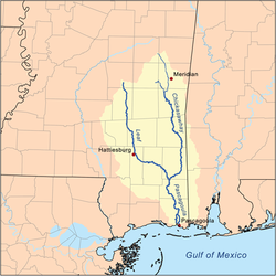
, about 80 mi (130 km) long, in southeastern Mississippi
Mississippi
Mississippi is a U.S. state located in the Southern United States. Jackson is the state capital and largest city. The name of the state derives from the Mississippi River, which flows along its western boundary, whose name comes from the Ojibwe word misi-ziibi...
in the United States. The river drains an area of about 8,800 sq mi (23,000 km²) and flows into Mississippi Sound
Mississippi Sound
The Mississippi Sound is a sound along the Gulf Coast of the United States. It runs east-west along the southern coasts of Mississippi and Alabama, from Waveland, Mississippi, to the Dauphin Island Bridge, a distance of about 145 kilometers...
of the Gulf of Mexico
Gulf of Mexico
The Gulf of Mexico is a partially landlocked ocean basin largely surrounded by the North American continent and the island of Cuba. It is bounded on the northeast, north and northwest by the Gulf Coast of the United States, on the southwest and south by Mexico, and on the southeast by Cuba. In...
.
It is significant as the only unaffected (or nearly so) river flowing into the Gulf of Mexico from the United States and the only one the Cfa
Humid subtropical climate
A humid subtropical climate is a climate zone characterized by hot, humid summers and mild to cool winters...
Köppen climate zone. As a result, the Pascagoula has in modern times been the focus of a great deal of effort regarding its conservation to prevent the constructions of dam
Dam
A dam is a barrier that impounds water or underground streams. Dams generally serve the primary purpose of retaining water, while other structures such as floodgates or levees are used to manage or prevent water flow into specific land regions. Hydropower and pumped-storage hydroelectricity are...
s on it.
Course
The Pascagoula River is formed in northwestern George CountyGeorge County, Mississippi
-Demographics:As of the census of 2000, there were 19,144 people, 6,742 households, and 5,305 families residing in the county. The population density was 40 people per square mile . There were 7,513 housing units at an average density of 16 per square mile...
by the confluence of the Leaf
Leaf River (Mississippi)
The Leaf River is a river, about 180 mi long, in southern Mississippi in the United States. It is a principal tributary of the Pascagoula River, which flows to the Gulf of Mexico.-Course:...
and Chickasawhay
Chickasawhay River
The Chickasawhay River is a river, about long, in southeastern Mississippi in the United States. It is a principal tributary of the Pascagoula River, which flows to the Gulf of Mexico. The Chickasawhay's tributaries also drain a portion of western Alabama...
Rivers and flows generally southward through swampy
Swamp
A swamp is a wetland with some flooding of large areas of land by shallow bodies of water. A swamp generally has a large number of hammocks, or dry-land protrusions, covered by aquatic vegetation, or vegetation that tolerates periodical inundation. The two main types of swamp are "true" or swamp...
bottomlands in George and Jackson
Jackson County, Mississippi
There were 47,676 households out of which 37.00% had children under the age of 18 living with them, 55.70% were married couples living together, 14.50% had a female householder with no husband present, and 25.10% were non-families. 20.80% of all households were made up of individuals and 7.10% had...
Counties. In its lower course the river forms several channels and bayou
Bayou
A bayou is an American term for a body of water typically found in flat, low-lying areas, and can refer either to an extremely slow-moving stream or river , or to a marshy lake or wetland. The name "bayou" can also refer to creeks that see level changes due to tides and hold brackish water which...
s; its largest such distributary
Distributary
A distributary, or a distributary channel, is a stream that branches off and flows away from a main stream channel. They are a common feature of river deltas. The phenomenon is known as river bifurcation. The opposite of a distributary is a tributary...
is the West Pascagoula River, which flows into the Mississippi Sound at Gautier
Gautier, Mississippi
Gautier is a city in Jackson County, Mississippi, United States, along the Gulf of Mexico west of Pascagoula. It is part of the Pascagoula, Mississippi Metropolitan Statistical Area. The population was 11,681 at the 2000 census. In 2002, Gautier annexed land nearly doubling its population to...
. The main channel passes Escatawpa
Escatawpa, Mississippi
Escatawpa is a census-designated place in Jackson County, Mississippi, United States. It is part of the Pascagoula, Mississippi Metropolitan Statistical Area. The population was 3,566 at the 2000 census.-History:...
and Moss Point
Moss Point, Mississippi
Moss Point is a city, north of Pascagoula, in Jackson County, Mississippi, United States. The population was 17,653 at the 2000 census.On August 29, 2005, Moss Point was hit by the strong east side of Hurricane Katrina, and much of Moss Point was flooded or destroyed .-Geography:Moss Point is...
and flows into the sound at Pascagoula
Pascagoula, Mississippi
Pascagoula is a city in Jackson County, Mississippi, United States. It is the principal city of the Pascagoula, Mississippi Metropolitan Statistical Area, as a part of the Gulfport–Biloxi–Pascagoula, Mississippi Combined Statistical Area. The population was 26,200 at the 2000 census...
.
Variant names
According to the Geographic Names Information SystemGeographic Names Information System
The Geographic Names Information System is a database that contains name and locative information about more than two million physical and cultural features located throughout the United States of America and its territories. It is a type of gazetteer...
, the river has also been known as:
- East Pascagoula River (below the branching off of the West Pascagoula River)
- Fiume Pescagoula
- Pasca Oocooloo River
- Pascoboula River
- Paska Okla River
- Paspagola River
- Pasquagola River
- Rio de Pascagula
- Riviere des Pascagoula
- Riviere des Pascagoulas
- Singing River (lower 8 miles of the river)