
Outline of the District of Columbia
Encyclopedia
Federal capital
A federal capital is a political entity that is or surrounds the capital city of a federal state. In countries with federal constitutions, power is divided between that of subnational states and a federal government...
of the United States of America, and was founded on July 16, 1790. The City of Washington was originally a separate municipality within the Territory of Columbia until the District of Columbia Organic Act of 1871
District of Columbia Organic Act of 1871
The District of Columbia Organic Act of 1871, formally An Act to provide a Government for the District of Columbia, is an Act of Congress, which created a territorial government for the District of Columbia. The act was the first to create a single government for the entire federal district and...
effectively merged the City and the Territory into a single entity. It is for this reason that the city, while legally named the District of Columbia, is known as Washington, D.C.
The following outline is provided as an overview of and topical guide to Washington, D.C.:
General reference
- Names
- Common name: District of Columbia
- PronunciationInternational Phonetic AlphabetThe International Phonetic Alphabet "The acronym 'IPA' strictly refers [...] to the 'International Phonetic Association'. But it is now such a common practice to use the acronym also to refer to the alphabet itself that resistance seems pedantic...
:
- Pronunciation
- Official name: The District of Columbia
- Abbreviations and name codes
- Postal symbol: DC
- ISO 3166-2 code: US-DC
- InternetInternetThe Internet is a global system of interconnected computer networks that use the standard Internet protocol suite to serve billions of users worldwide...
second-level domainSecond-level domainIn the Domain Name System hierarchy, a second-level domain is a domain that is directly below a top-level domain . For example, in example.com, example is the second-level domain of the .com TLD....
: .dc.us
- Nicknames
- A Capital City (previously used on license platesVehicle registration plates of Washington, D.C.The U.S. federal district of Washington, D.C. first required its residents to register their motor vehicles and display license plates in 1907.-Passenger baseplates 1985 to present:-Non-passenger types:-Optional types:-External links:**...
) - The Federal City
- Taxation without Representation (currently used on License Plates)
- The District
- A Capital City (previously used on license plates
- Common name: District of Columbia
- Adjectivals:
- District of Columbia
- DistrictWashington, D.C.Washington, D.C., formally the District of Columbia and commonly referred to as Washington, "the District", or simply D.C., is the capital of the United States. On July 16, 1790, the United States Congress approved the creation of a permanent national capital as permitted by the U.S. Constitution....
- D.C.Washington, D.C.Washington, D.C., formally the District of Columbia and commonly referred to as Washington, "the District", or simply D.C., is the capital of the United States. On July 16, 1790, the United States Congress approved the creation of a permanent national capital as permitted by the U.S. Constitution....
- Washington, D.C.Washington, D.C.Washington, D.C., formally the District of Columbia and commonly referred to as Washington, "the District", or simply D.C., is the capital of the United States. On July 16, 1790, the United States Congress approved the creation of a permanent national capital as permitted by the U.S. Constitution....
- The Federal City
- WashingtonWashington, D.C.Washington, D.C., formally the District of Columbia and commonly referred to as Washington, "the District", or simply D.C., is the capital of the United States. On July 16, 1790, the United States Congress approved the creation of a permanent national capital as permitted by the U.S. Constitution....
- WashingtonianWashington, D.C.Washington, D.C., formally the District of Columbia and commonly referred to as Washington, "the District", or simply D.C., is the capital of the United States. On July 16, 1790, the United States Congress approved the creation of a permanent national capital as permitted by the U.S. Constitution....
- Demonym: Washingtonian
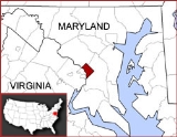
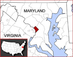
Geography of the District of Columbia
- Main article: Geography of Washington, D.C.Geography of Washington, D.C.Washington, D.C., US, is located at . According to the United States Census Bureau, the city has a geographical area of , of which is land, and the remaining of which is water....
- The District of Columbia is: The federal capital district of the United States of America
- Location
- Northern hemisphereNorthern HemisphereThe Northern Hemisphere is the half of a planet that is north of its equator—the word hemisphere literally means “half sphere”. It is also that half of the celestial sphere north of the celestial equator...
- Western hemisphereWestern HemisphereThe Western Hemisphere or western hemisphere is mainly used as a geographical term for the half of the Earth that lies west of the Prime Meridian and east of the Antimeridian , the other half being called the Eastern Hemisphere.In this sense, the western hemisphere consists of the western portions...
- AmericasAmericasThe Americas, or America , are lands in the Western hemisphere, also known as the New World. In English, the plural form the Americas is often used to refer to the landmasses of North America and South America with their associated islands and regions, while the singular form America is primarily...
- North AmericaNorth AmericaNorth America is a continent wholly within the Northern Hemisphere and almost wholly within the Western Hemisphere. It is also considered a northern subcontinent of the Americas...
- Anglo America
- Northern AmericaNorthern AmericaNorthern America is the northernmost region of the Americas, and is part of the North American continent. It lies directly north of the region of Middle America; the land border between the two regions coincides with the border between the United States and Mexico...
- United States of America
- Contiguous United StatesContiguous United StatesThe contiguous United States are the 48 U.S. states on the continent of North America that are south of Canada and north of Mexico, plus the District of Columbia....
- Eastern United StatesEastern United StatesThe Eastern United States, the American East, or simply the East is traditionally defined as the states east of the Mississippi River. The first two tiers of states west of the Mississippi have traditionally been considered part of the West, but can be included in the East today; usually in...
- East Coast of the United StatesEast Coast of the United StatesThe East Coast of the United States, also known as the Eastern Seaboard, refers to the easternmost coastal states in the United States, which touch the Atlantic Ocean and stretch up to Canada. The term includes the U.S...
– even though the District of Columbia does not include any actual coastline, it is generally considered to be part of the Eastern Seaboard region.- Northeast megalopolisNortheast megalopolisThe Northeast megalopolis or Boston–Washington megalopolis is the heavily urbanized area of the United States stretching from the the northern suburbs of Boston, Massachusetts to the southern suburbs of Washington, D.C. On a map, the region appears almost as a perfectly straight line. As of 2000,...
- Northeast megalopolis
- Mid-Atlantic statesMid-Atlantic StatesThe Mid-Atlantic states, also called middle Atlantic states or simply the mid Atlantic, form a region of the United States generally located between New England and the South...
- East Coast of the United States
- Eastern United States
- Contiguous United States
- United States of America
- North America
- Americas
- Northern hemisphere
- Population of Washington, D.C.: 601,723 (2010 U.S. Census)
- Area of Washington, D.C.: 63.8 mi sq
- Atlas of Washington, D.C.
Places in Washington, D.C.
- Historic places in Washington, D.C.
- National Historic Landmarks in Washington, D.C.
- National Register of Historic Places listings in Washington, D.C.National Register of Historic Places listings in Washington, D.C.This is a list of properties and districts in the District of Columbia on the National Register of Historic Places. There are more than 500 listings, including 74 National Historic Landmarks of the United States and another 13 places otherwise designated as historic sites of national importance by...
- Bridges on the National Register of Historic Places in Washington, D.C.
- National Register of Historic Places listings in Northeast Quadrant, Washington, D.C.
- National Register of Historic Places listings in Southeast Quadrant, Washington, D.C.
- National Register of Historic Places listings in Southwest Quadrant, Washington, D.C.
- National Register of Historic Places listings in Northwest Quadrant, Washington, D.C.
- National Monuments in Washington, D.C.
- President Lincoln's Cottage at the Soldiers' HomePresident Lincoln's Cottage at the Soldiers' HomePresident Lincoln's Cottage is a national monument on the grounds of the Soldiers' Home, known today as the Armed Forces Retirement Home. It is located in the Petworth and Park View neighborhoods of Washington, D.C....
- President Lincoln's Cottage at the Soldiers' Home
- National Natural LandmarkNational Natural LandmarkThe National Natural Landmark program recognizes and encourages the conservation of outstanding examples of the natural history of the United States. It is the only natural areas program of national scope that identifies and recognizes the best examples of biological and geological features in...
s in Washington, D.C.: none - National Parks in Washington, D.C. (official units of the U.S. National Park System)
- Carter G. Woodson Home National Historic SiteCarter G. Woodson Home National Historic SiteCarter G. Woodson Home National Historic Site at 1538 9th Street, NW in the Shaw neighborhood of Washington, D.C., preserves the home of Carter G. Woodson . Woodson, the founder of Black History Month, was an African American historian, author, and journalist.-History:The property served as Dr....
- Constitution GardensConstitution GardensConstitution Gardens is a park area in Washington, D.C., United States, located within the boundaries of the National Mall. The park is bounded on the west by the Vietnam Veterans Memorial, on the east by 17th St NW, on the north by Constitution Avenue, and on the south by the Reflecting Pool...
- Ford's Theatre National Historic Site
- Franklin D. Roosevelt Memorial
- Frederick Douglass National Historic SiteFrederick Douglass National Historic SiteThe Frederick Douglass National Historic Site, administered by the National Park Service, is located at 1411 W St., SE in Anacostia, a neighborhood east of the Anacostia River in Southeast Washington, D.C.. Established in 1988 as a National Historic Site, the site preserves the home and estate of...
- Korean War Veterans MemorialKorean War Veterans MemorialThe Korean War Veterans Memorial is located in Washington, D.C.'s West Potomac Park, southeast of the Lincoln Memorial and just south of the Reflecting Pool on the National Mall...
- Lincoln MemorialLincoln MemorialThe Lincoln Memorial is an American memorial built to honor the 16th President of the United States, Abraham Lincoln. It is located on the National Mall in Washington, D.C. The architect was Henry Bacon, the sculptor of the main statue was Daniel Chester French, and the painter of the interior...
- Lyndon Baines Johnson Memorial Grove on the PotomacLyndon Baines Johnson Memorial Grove on the PotomacLyndon Baines Johnson Memorial Grove on the Potomac is located on Columbia Island in Washington, D.C. The memorial honors the 36th President of the United States, Lyndon B. Johnson....
- Mary McLeod Bethune Council House National Historic SiteMary McLeod Bethune Council House National Historic SiteThe Mary McLeod Bethune Council House National Historic Site preserves the house of Mary McLeod Bethune, located in Northwest Washington, D.C., at 1318 Vermont Avenue. National Park Service rangers offer tours of the home, and a video is shown about Bethune's life.-External links:* *...
- National Capital Parks
- National MallNational MallThe National Mall is an open-area national park in downtown Washington, D.C., the capital of the United States. The National Mall is a unit of the National Park Service , and is administered by the National Mall and Memorial Parks unit...
- Pennsylvania Avenue National Historic SitePennsylvania Avenue National Historic SitePennsylvania Avenue National Historic Site is a National Historic Site in the city of Washington, D.C. Established on September 30, 1965, the site is roughly bounded by Constitution Avenue, 15th Street NW, F Street NW, and 3rd Street NW...
- Rock Creek ParkRock Creek ParkRock Creek Park is a large urban natural area with public park facilities that bisects Washington, D.C. The park is administered by the National Park Service.-Rock Creek Park:The main section of the park contains , or , along the Rock Creek Valley...
- Theodore Roosevelt IslandTheodore Roosevelt IslandTheodore Roosevelt Island is a island and a national memorial located in the Potomac River in Washington, D.C. The island was given to the American people by the Theodore Roosevelt Association in memory of the 26th U.S. president, Theodore Roosevelt....
- Thomas Jefferson Memorial
- Vietnam Veterans MemorialVietnam Veterans MemorialThe Vietnam Veterans Memorial is a national memorial in Washington, D.C. It honors U.S. service members of the U.S. armed forces who fought in the Vietnam War, service members who died in service in Vietnam/South East Asia, and those service members who were unaccounted for during the War.Its...
- Washington MonumentWashington MonumentThe Washington Monument is an obelisk near the west end of the National Mall in Washington, D.C., built to commemorate the first U.S. president, General George Washington...
- White HouseWhite HouseThe White House is the official residence and principal workplace of the president of the United States. Located at 1600 Pennsylvania Avenue NW in Washington, D.C., the house was designed by Irish-born James Hoban, and built between 1792 and 1800 of white-painted Aquia sandstone in the Neoclassical...
- World War II Memorial
- Carter G. Woodson Home National Historic Site
- City parks in Washington, D.C.
Environment of the District of Columbia
- Climate of Washington, D.C.
- Hurricanes in Washington, D.C.
- Tornados in Washington, D.C.
- Superfund sites in Washington, D.C.
Natural geographic features of the District of Columbia
- Rivers of Washington, D.C.
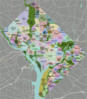
Subdivisions of Washington, D.C.
- District of Columbia's At-large congressional districtDistrict of Columbia's At-large congressional districtThe District of Columbia's At-large congressional district is a congressional district based entirely of the District of Columbia. Since, according to the U.S. Constitution, only states may be represented in Congress, the District of Columbia has no voting representative. Instead, constituents in...
- District of Columbia census statistical areasDistrict of Columbia census statistical areasThe United States Census Bureau has defined one Combined Statistical Area and one Metropolitan Statistical Area in the District of Columbia. The following table describes these areas with the following information:...
Quadrants of Washington, D.C.
- Northwest, Washington, D.C.
- Northeast, Washington, D.C.
- Southeast, Washington, D.C.
- Southwest, Washington, D.C.
Neighborhoods of the District of Columbia
The District of Columbia is divided into eight wards and 37 Advisory Neighborhood CommissionAdvisory Neighborhood Commission
thumb|right|upright|The District of Columbia is divided into 8 wards, each of which is further divided into local ANCs.Advisory Neighborhood Commissions are bodies of local government in Washington, D.C...
s (ANCs) within these wards.
Ward 1
Adams Morgan
Adams Morgan
Adams Morgan is a culturally diverse neighborhood in Northwest Washington, D.C., centered at the intersection of 18th Street and Columbia Road. Adams Morgan is considered the center of Washington's Hispanic immigrant community, and is a major night life area with many bars and restaurants,...
• Columbia Heights
Columbia Heights, Washington, D.C.
Columbia Heights is a neighborhood in central Washington, D.C.-Geography:Located in the Northwest quadrant of Washington, D.C., Columbia Heights borders the neighborhoods of Shaw, Adams Morgan, Mount Pleasant, Park View, Pleasant Plains, and Petworth. On the eastern side is Howard University...
• Kalorama
Kalorama, Washington, D.C.
The Kalorama area within the Northwest Quadrangle of Washington, D.C., includes two adjacent, quite affluent historical residential neighborhoods, Kalorama Triangle and Sheridan-Kalorama. The area is accessible from the Dupont Circle and Woodley Park Metro stations, as well as various bus lines...
• LeDroit Park
• Mount Pleasant
Mount Pleasant, Washington, D.C.
Mount Pleasant is a neighborhood in the northwestern quadrant of Washington, D.C., the capital of the United States. The neighborhood is bounded by Rock Creek Park to the north and west; and Harvard Street, NW and the Adams Morgan neighborhood to the south; and Sixteenth Street, NW and the Columbia...
• Park View
Park View, Washington, D.C.
Park View is a neighborhood in central Washington, D.C., immediately north of Howard University.The name of the neighborhood comes from its views east over the campus of the Old Soldiers' Home. At the time Park View was developed, and well into the 1960s, the Home's grounds were open to the public...
• Pleasant Plains
Pleasant Plains, Washington, D.C.
Pleasant Plains is a neighborhood in central Washington, D.C. largely occupied by Howard University. For this reason it is also sometimes referred to as Howard Town or, less frequently, Howard Village....
• Shaw
Shaw, Washington, D.C.
Shaw is a neighborhood located in the Northwest quadrant of Washington, D.C. It is roughly bounded by M Street, NW or Massachusetts Avenue NW to the south; New Jersey Avenue, NW to the east; Florida Avenue, NW to the north; and 11th Street, NW to the west...
Ward 2
Burleith
Burleith
Burleith is a moderately upscale neighborhood in Washington, D.C. It is bordered by Wisconsin Avenue to the East, Reservoir Road and the historic Georgetown district to the south, Whitehaven Park to the North and Glover Archbold Park to the West...
• Downtown
Downtown Washington, D.C.
Downtown is a neighborhood of Washington, D.C., as well as a colloquial name for the central business district in the northwest quadrant of the city. Geographically, the area extends roughly five to six blocks west, northwest, north, northeast, and east of the White House...
• Dupont Circle
Dupont Circle
Dupont Circle is a traffic circle, park, neighborhood, and historic district in Northwest Washington, D.C. The traffic circle is located at the intersection of Massachusetts Avenue NW, Connecticut Avenue NW, New Hampshire Avenue NW, P Street NW, and 19th Street NW...
• Foggy Bottom
Foggy Bottom
Foggy Bottom is one of the oldest late 18th and 19th-century neighborhoods in Washington, D.C. The area is thought to have received the name because its riverside location made it susceptible to concentrations of fog and industrial smoke, an atmospheric trait that did not prevent the neighborhood...
• Georgetown
Georgetown, Washington, D.C.
Georgetown is a neighborhood located in northwest Washington, D.C., situated along the Potomac River. Founded in 1751, the port of Georgetown predated the establishment of the federal district and the City of Washington by 40 years...
• Sheridan Kalorama
Kalorama, Washington, D.C.
The Kalorama area within the Northwest Quadrangle of Washington, D.C., includes two adjacent, quite affluent historical residential neighborhoods, Kalorama Triangle and Sheridan-Kalorama. The area is accessible from the Dupont Circle and Woodley Park Metro stations, as well as various bus lines...
• Logan Circle
• Mount Vernon Square
Mount Vernon Square
Mount Vernon Square is a city square in the Northwest quadrant of Washington, D.C. It is located where the following streets would otherwise intersect: Massachusetts Avenue, New York Avenue, K Street, and 8th Street NW....
• Shaw
Shaw, Washington, D.C.
Shaw is a neighborhood located in the Northwest quadrant of Washington, D.C. It is roughly bounded by M Street, NW or Massachusetts Avenue NW to the south; New Jersey Avenue, NW to the east; Florida Avenue, NW to the north; and 11th Street, NW to the west...
• West End
West End, Washington, D.C.
The West End is a neighborhood of the Northwest quadrant of Washington, D.C., bounded by K Street to the south, Rock Creek Park to the west and north, and New Hampshire Avenue and 21st Street to the east. The West End is so named because it was the westernmost part of the original Pierre L'Enfant...
Ward 3
American University Park
American University Park
American University Park is a neighborhood of Washington, DC, named for the American University. AU Park, as it is often abbreviated, is situated against the Maryland border in the Northwest quadrant, bounded by Massachusetts, Wisconsin, Nebraska, and Western Avenues...
• Berkley
Berkley, Washington, D.C.
Berkley is a neighborhood in the Northwest quadrant of Washington, D.C. It is sometimes referred to as Foxhall Crescents, after a housing development built within the neighborhood.- Geography :...
• Cathedral Heights
Cathedral Heights
Cathedral Heights is a small, residential neighborhood located in the Northwest quadrant of Washington, D.C. It is approximately bounded by Woodley Road to the north, Fulton Street to the south, Wisconsin Avenue to the east, and Glover Archbold Park and Idaho Avenue to the...
• Chevy Chase
Chevy Chase, Washington, D.C.
Chevy Chase is a neighborhood in northwest Washington, D.C. It borders Chevy Chase, Maryland, a collection of similarly affluent neighborhoods.-Geography:...
• Cleveland Park
Cleveland Park
Cleveland Park is a residential neighborhood in the Northwest quadrant of Washington, D.C.It is located at and bounded approximately by Rock Creek Park to the east, Wisconsin and Idaho Avenues to the west, Klingle and Woodley Roads to the south, and Rodman and Tilden Streets to the north...
• Colony Hill
Colony Hill, Washington, D.C.
Colony Hill is a tiny neighborhood located in the southwest corner of Glover Archbold Park in Northwest Washington, D.C. It is bounded on the north and east by the park, on the south by Reservoir Road NW, and on the west by Foxhall Road NW....
• Forest Hills
Forest Hills, Washington, D.C.
Forest Hills is a quiet residential neighborhood in the northwest quadrant of Washington, D.C., United States, bounded by Connecticut Avenue NW to the west, Rock Creek Park to the east, Chevy Chase to the north, and Tilden Street NW to the south...
• Foxhall
Foxhall, Washington, D.C.
Foxhall is an affluent neighborhood in Washington, D.C., bordered by Reservoir Road on the north side and Foxhall Road on the west and south sides. Glover-Archibold Park makes up the eastern border....
• Friendship Heights
Friendship Heights
Friendship Heights is a residential neighborhood in northwest Washington, D.C. and southern Montgomery County, Maryland. Though its borders are not clearly defined, Friendship Heights consists roughly of the neighborhoods and commercial areas around Wisconsin Avenue north of Fessenden Street NW and...
• Glover Park
Glover Park
Glover Park is a neighborhood in northwest Washington, D.C., about a half mile north of Georgetown and just west of the United States Naval Observatory and Number One Observatory Circle...
• Kent
Kent, Washington, D.C.
Kent is a neighborhood in Northwest Washington, D.C., bounded by Loughboro Road to the north, MacArthur Boulevard to the southwest, and Chain Bridge Road and Battery Kemble Park to the southeast....
• Massachusetts Heights
Massachusetts Heights
Massachusetts Heights is a small neighborhood in Northwest Washington, DC, dominated by the grounds of the Washington National Cathedral.The neighborhood is bounded to the north by Woodley Road, to the southwest by Massachusetts Avenue, to the east by 34th Street NW, and to the west by Wisconsin...
• McLean Gardens
McLean Gardens
McLean Gardens is a residential neighborhood in Northwest Washington, D.C., bounded by Rodman Street NW to the north, Idaho Avenue to the south, Wisconsin Avenue to the east, and 39th Street NW to the west....
• North Cleveland Park
North Cleveland Park
North Cleveland Park is a neighborhood in the Northwest quadrant of Washington, D.C.It's home to the Van Ness campus of the University of the District of Columbia and the headquarters of Intelsat, a major employer in the area....
• Observatory Circle
Observatory Circle
Observatory Circle is a street in Washington, D.C. It runs from Calvert Street to Massachusetts Avenue near 34th Street. The street follows an incomplete loop, forming an arc rather than a circle...
• The Palisades
The Palisades, Washington, D.C.
The Palisades is a neighborhood in Washington, D.C., along the Potomac River, running roughly from the edge of the Georgetown University campus to the D.C.-Maryland boundary...
• Potomac Heights
Potomac Heights, Washington, D.C.
Potomac Heights is a neighborhood in Washington, D.C. Washington, D.C., overlooking the Potomac River from MacArthur Boulevard westward. Potomac Heights is bounded to the north by Loughboro Road and to the south by Chain Bridge and Arizona Avenue NW...
• Spring Valley
Spring Valley, Washington, D.C.
Spring Valley is an affluent neighborhood in northwest Washington, D.C., known for its large homes and tree-lined streets.The neighborhood houses the main campus of American University at 4400 Massachusetts Avenue, the Wesley Theological Seminary at 4500 Massachusetts Avenue, and Washington College...
• Tenleytown
Tenleytown
Tenleytown is a historic neighborhood in Northwest, Washington, DC.-History:In 1790, Washington locals began calling the neighborhood "Tennally's Town" after area tavern owner John Tennally...
• Wakefield
Wakefield, Washington, D.C.
Wakefield is a neighborhood in the Northwest quadrant of Washington, D.C., bounded by Albemarle Street NW to the south, Nebraska Avenue NW to the west, and Connecticut Avenue to the east. It is served by the Van Ness-UDC and Tenleytown-AU station on the Washington Metro's Red Line ....
• Wesley Heights
Wesley Heights
Wesley Heights is a small neighborhood of Washington, DC situated south of Tenleytown. It is bordered by New Mexico Avenue , Nebraska Avenue , Battery-Kemble Park and Glover Parkway . Foxhall Road is the main roadway passing through Wesley Heights. Wesley Heights is in Northwest, in Ward 3 and...
• Woodland-Normanstone Terrace
Woodland-Normanstone Terrace
Woodland-Normanstone Terrace is a small residential neighborhood in Northwest Washington, DC, adjoining the larger neighborhoods of Woodley Park, Massachusetts Heights, and Observatory Circle...
• Woodley Park (Part of the neighborhood is also in Ward 1)
Ward 4
Barnaby Woods, Washington, D.C.
On November 4, 1934, Edward R. Carr headed up the Barnaby Woods Development Company, formed to develop the 23 acre tract in Chevy Chase, DC. Claude G. Johnson and M.B Swanson are also credited with the promotion and realization of this community. Thomas C...
• Brightwood
Brightwood, Washington, D.C.
Brightwood is a neighborhood located in the northwestern quadrant of Washington, D.C. Brightwood and the rest of Ward 4 are represented in the Council of the District of Columbia by Muriel Bowser.- Geography :...
• Brightwood Park
Brightwood Park
Brightwood Park is a small neighborhood in Northwest Washington, D.C. in the USA. The neighborhood is bounded by Georgia Avenue NW to the west, Missouri Avenue NW to the northeast and Kennedy Street NW to the south...
• Chevy Chase
Chevy Chase, Washington, D.C.
Chevy Chase is a neighborhood in northwest Washington, D.C. It borders Chevy Chase, Maryland, a collection of similarly affluent neighborhoods.-Geography:...
(Part of the neighborhood is also in Ward 3)
• Colonial Village
Colonial Village, Washington, D.C.
Colonial Village is an affluent residential neighborhood in northwest Washington, D.C. It is bounded by Portal Drive to the north, 16th Street to the east, and Rock Creek Park to the west and south...
• Crestwood
Crestwood, Washington, D.C.
Crestwood, which forms part of the residential area known as the Gold Coast on upper 16th Street NW, is an entirely residential neighborhood located in Northwest Washington, D.C. and bordered on three sides by Rock Creek Park. It is known for its affluent, educated and majority black population...
• Fort Totten
Fort Totten, Washington, D.C.
Fort Totten is a park and neighborhood in northeast Washington, D.C.. The neighborhood is bordered by N Capitol St to the west, Riggs Rd NE to the north, the Red Line tracks to the east, and Hawaii Ave NE to the south. It is named after a Civil War-era fort. The Fort Totten Metro station is named...
• Hawthorne
Hawthorne, Washington, D.C.
Hawthorne is a neighborhood in the Northwest quadrant of Washington, D.C., wedged between Rock Creek Park and Montgomery County, Maryland. It is entirely residential, with no commercial zoning whatsoever, and is occupied by 1950s ramblers and split-level homes on large parcels of land — suburban...
• Manor Park
Manor Park, Washington, D.C.
Manor Park is an averaged-sized neighborhood in northwest Washington, D.C.. The 1967 National Capitol Planning Commission 1967 "District Communities" map indicates this neighborhood is roughly bounded by Fifth Street NW on the west, North Capitol Street and Blair Road on the east, Aspen Street to...
• Petworth
Petworth, Washington, D.C.
Petworth is a residential neighborhood in the Northwest quadrant of Washington, D.C., bounded by Georgia Avenue to the west, North Capitol Street to the east, Rock Creek Church Road to the south, and Kennedy Street NW to the north...
• Riggs Park
Riggs Park
Riggs Park is a residential neighborhood in Northeast Washington, D.C. It is bounded by Riggs Road NE to the south and east, Eastern Avenue to the north, and Blair Road NE, Kansas Avenue NE, and North Capitol Street NE to the west....
• Lamond-Riggs
• Shepherd Park
Shepherd Park
Shepherd Park is a neighborhood in the northwest quadrant of Washington, D.C. In the years following World War II, restrictive covenants which had prevented Jews and African Americans from purchasing homes in the neighborhood were no longer enforced, and the neighborhood became largely Jewish and...
• Sixteenth Street Heights
Sixteenth Street Heights
Sixteenth Street Heights is a large neighborhood of rowhouses, duplexes, and American Craftsman and American Foursquare detached houses in Northwest Washington, D.C..-Geography:...
• Takoma
Ward 5
Arboretum
• Bloomingdale
Bloomingdale, Washington, D.C.
The neighborhood of Bloomingdale is in the heart of Washington, D.C. less than two miles north of the United States Capitol building. Specifically, Bloomingdale lies south of Channing Street, N.W., east of 2nd Street, N.W. , east of Third Street, N.W. , north of Florida Avenue, N.W., and west of...
• Brentwood
Brentwood, Washington, D.C.
Brentwood is a neighborhood in Northeast Washington, D.C. and is named after the Brentwood Mansion built at Florida Avenue and 6th Street NE in 1817 by Robert Brent, the first mayor of Washington City. He built it as a wedding present for his daughter Eleanor on her marriage as second wife to...
• Brookland
Brookland, Washington, D.C.
Brookland is a neighborhood in the Northeast quadrant of Washington, D.C., historically centered along 12th Street NE. Brookland is bounded by 9th Street NE to the west, Rhode Island Avenue NE to the south, and South Dakota Avenue to the east...
• Carver Langston
Carver Langston
Carver Langston is a cluster of two neighborhoods, Carver and Langston, just south of the United States National Arboretum in Northeast Washington, D.C. The two neighborhoods are most often referred to as one, because they are two small triangular neighborhoods that together form a square of land...
• Eckington
Eckington, Washington, D.C.
Eckington is a neighborhood in Northeast Washington, D.C. located south of the Prospect Hill and Glenwood Cemeteries. Eckington is less than one mile southeast of Howard University and exactly one mile north of the United States Capitol...
• Edgewood
Edgewood, Washington, D.C.
Edgewood is a neighborhood in Northeast Washington, D.C Edgewood is bounded by Lincoln Road and Glenwood Cemetery to the west; the tracks for the Red Line of the Washington Metro to the east; Rhode Island Avenue NE to the south; and the combination of Irving Street, Michigan Avenue, and Monroe...
• Fort Lincoln
Fort Lincoln, Washington, D.C.
Fort Lincoln is a neighborhood located in northeastern Washington, D.C. It is bounded by Bladensburg Road to the northwest, Eastern Avenue to the northeast, New York Avenue NE to the south, and South Dakota Avenue NE to the southwest...
• Fort Totten
Fort Totten, Washington, D.C.
Fort Totten is a park and neighborhood in northeast Washington, D.C.. The neighborhood is bordered by N Capitol St to the west, Riggs Rd NE to the north, the Red Line tracks to the east, and Hawaii Ave NE to the south. It is named after a Civil War-era fort. The Fort Totten Metro station is named...
(Part of the neighborhood is also in Ward 4)
• Gateway
Gateway (neighborhood), Washington, D.C.
Gateway is the name of a small industrial and residential neighborhood in Northeast Washington, D.C. It is bounded by New York Avenue NE to the south and southeast, Bladensburg Road to the west, and South Dakota Avenue to the northeast. Gateway is across New York Avenue from the U.S...
• Ivy City
Ivy City, Washington, D.C.
Ivy City is a small neighborhood in Northeast Washington. It is primarily an industrial neighborhood, dominated by warehouses and the Ivy City Yard, a railroad coach yard and maintenance facility for Amtrak. The area has undergone some revitalization with the influx of a few dance clubs and the...
• Riggs Park
Riggs Park
Riggs Park is a residential neighborhood in Northeast Washington, D.C. It is bounded by Riggs Road NE to the south and east, Eastern Avenue to the north, and Blair Road NE, Kansas Avenue NE, and North Capitol Street NE to the west....
(Part of the neighborhood is also in Ward 4)
• Langdon
Langdon, Washington, D.C.
Langdon, or Langdon Park, is a neighborhood near the U.S. National Arboretum in Northeast Washington, D.C. Langdon is roughly bounded by New York Avenue NE to the south, Montana Avenue to the west, Bladensburg Road to the east, Rhode Island Avenue NE to the northwest, and South Dakota Avenue to the...
• Michigan Park
Michigan Park, Washington, D.C.
Michigan Park is a neighborhood in Northeast Washington, D.C.. It is bordered by Gallatin Street NE to the north, 6th Street NE to the to west, Taylor Street NE and Michigan Avenue to the south, and South Dakota Avenue to the east....
• North Michigan Park
North Michigan Park, Washington, D.C.
North Michigan Park is a neighborhood in Northeast Washington, D.C.. It is bordered by Gallatin Street NE to the north, South Dakota Avenue to the to west, Michigan Avenue to the south, and Eastern Avenue to the east....
• Pleasant Hill
• Stronghold/Metropolis View
Stronghold/Metropolis View, Washington, D.C.
Stronghold is the name of a neighborhood in Northeast Washington, D.C. It is also called Metropolis View after the estate that originally occupied its area in the 1830s.There are two different boundaries...
• Trinidad
Trinidad, Washington, D.C.
Trinidad is a neighborhood located in Ward 5, in the northeast quadrant of Washington, D.C. and is a largely residential area.-Geography:Trinidad is bounded to the north by Mt. Olivet Road, to the west by West Virginia Avenue, to the south by Florida Avenue, and to the east by Bladensburg Road. To...
• Truxton Circle
Truxton Circle, Washington, D.C.
Truxton Circle is a trapezoid shaped neighborhood of Northwest Washington, D.C., bordered by New Jersey Avenue to the west, Florida Avenue to the north, New York Avenue to the South, and North Capitol Street to the East. Politically, it is partially in Ward 5...
• Woodridge
Woodridge, Washington, D.C.
Woodridge, is a residential neighborhood located on the northeastern edge of Washington, D.C., bounded by Eastern Avenue on the east, Michigan Avenue to the north, South Dakota then 18th St. to the west, and Bladensburg Road to the south. Its central commercial strip is Rhode Island Avenue NE. It...
Ward 6
Barney Circle
Barney Circle, Washington, D.C.
Barney Circle is a small neighborhood located on the western bank of the Anacostia River in southeast Washington, D.C. The "circle" refers to the traffic circle that intersects Pennsylvania Avenue SE as it crosses the Anacostia...
• Capitol Hill
Capitol Hill, Washington, D.C.
Capitol Hill, aside from being a metonym for the United States Congress, is the largest historic residential neighborhood in Washington D.C., stretching easterly in front of the United States Capitol along wide avenues...
• Chinatown
Chinatown, Washington, D.C.
Chinatown in Washington, D.C., is a small, historic neighborhood east of downtown consisting of about 20 ethnic Chinese and other Asian restaurants and small businesses along H and I Streets between 5th and 8th Streets, Northwest. It is known for its annual Chinese New Year festival and parade and...
• Judiciary Square
Judiciary Square
Judiciary Square is a neighborhood in Northwest Washington, D.C., the vast majority of which is occupied by various federal and municipal courthouses and office buildings...
• Kingman Park
Kingman Park, Washington, D.C.
Kingman Park is a residential neighborhood in the Northeast quadrant of Washington, D.C., the capital city of the United States. Kingman Park's boundaries are 15th Street NE to the west; C Street SE to the south; Benning Road to the north; and Anacostia Park to the east...
• Navy Yard/Near Southeast
Navy Yard/Near Southeast
Navy Yard, also known as Near Southeast, is a neighborhood on the Anacostia River in Southeast Washington, D.C. Navy Yard is bounded by Interstate 395 to the north, South Capitol Street to the west, and the Anacostia River to the south and east...
• Near Northeast
Old City/Near Northeast
Near Northeast is a neighborhood in Northeast Washington, D.C.. It is bounded by North Capitol Street to the west, Florida Avenue to the north, H Street to the south, and 15th Street to the east.-History:...
• Penn Quarter
Penn Quarter, Washington, D.C.
Penn Quarter is a neighborhood in the East End of Downtown Washington, D.C. north of Pennsylvania Avenue, NW. Its boundaries are not well established, but they appear to extend to 5th and 10th streets NW on the east and west, and approximately H Street on the north where Penn Quarter abuts or...
• NoMa
NoMa, Washington, D.C.
NoMa is a portmanteau of the words "North of Massachusetts Avenue" that is being used by real estate developers to brand a large tract of land in Washington DC that is located just north of Capitol Hill and Union Station...
, Washington, D.C.
• Southwest Federal Center
Southwest Federal Center
Southwest Federal Center is a business district in Southwest Washington, D.C., nearly entirely occupied by offices for various branches of the U.S...
• Southwest Waterfront
Southwest Waterfront
Southwest Waterfront is a residential neighborhood in Southwest Washington, D.C.. Southwest is the smallest of Washington's four quadrants, and Southwest Waterfront is one of only two residential neighborhoods in the quadrant; the other is Bellevue, which, being east of the Anacostia River, is...
• Sursum Corda
Sursum Corda Cooperative
Sursum Corda Cooperative is a small neighborhood located in Washington, D.C., bounded by North Capitol Street on the east, First Street NW to the west, K Street NW to the south, and New York Avenue NW to the north. It consists of 199 housing units constructed as an experiment in cooperatively...
• Swampoodle
Swampoodle
Swampoodle was an Irish neighborhood in Washington, D.C.. A geographic approximation of its borders would be K Street to the north, G Street to the south, 1st Street NW to the west, and 2nd Street NE to the east. Through the center of it ran the principal branch of Tiber Creek...
• Union Station
Union Station (Washington, D.C.)
Washington Union Station is a train station and leisure destination visited by 32 million people each year in the center of Washington, D.C. The train station is served by Amtrak, MARC and Virginia Railway Express commuter rail services as well as by Washington Metro subway trains and local buses...
Ward 7
Benning Heights
Benning Heights, Washington, D.C.
Benning Heights is a residential neighborhood located in Northeast Washington, D.C. It is bounded by East Capitol Street to the south, Brooks Street NE to the north, 42nd Street NE and Benning Road to the west, and Division Avenue NE to the east. It is served by the Benning Road station on the Blue...
• Benning Ridge
Benning Ridge, Washington, D.C.
Benning Ridge is a residential neighborhood located in Southeast Washington, D.C. It is bounded by Fort Chaplin Park to the northwest, Southern Avenue to the south, Benning Road to the east, and Ridge Road SE to the west...
• Benning
Benning, Washington, D.C.
Benning is a residential neighborhood located in Northeast Washington, D.C. It is bounded by East Capitol Street to the south, Minnesota Avenue to the west, and Benning Road on the north and east...
• Burrville
• Capitol View
Capitol View, Washington, D.C.
Capitol View is a neighborhood located in both southeast Washington, D.C, straddling East Capitol Street east of the Anacostia River. It is triangular in area, bounded by East Capitol Street to the north, Central Avenue SE to the southwest, and Southern Avenue to the southeast. Capital View is...
• Civic Betterment
Civic Betterment
Civic Betterment is a small neighborhood located in Southeast Washington, D.C, on the border of Prince George's County, Maryland. It is triangular in area, bounded by G and Fitch Streets SE to the north, Benning Road SE to the southwest, and Southern Avenue to the southeast....
• Deanwood
Deanwood
Deanwood is a neighborhood in Northeast Washington, D.C., bounded by Eastern Avenue to the northeast, Kenilworth Avenue to the northwest, and Nannie Helen Burroughs Avenue to the south....
• Dupont Park
Dupont Park
Dupont Park is a residential neighborhood located in southeast Washington, D.C. It is bounded by Fort Dupont Park to the north, Pennsylvania Avenue SE to the south, Branch Avenue to the west, and Fort Davis Park to the east....
• Eastland Gardens
Eastland Gardens, Washington, D.C.
Eastland Gardens is a small residential neighborhood, founded in 1935, located in northeast Washington, D.C. It is bounded by Eastern Avenue NE to the north, the Watts Branch Tributary to the south, CSX Transportation tracks to the east and the Anacostia River to the west....
• Fairfax Village
Fairfax Village, Washington, D.C.
Fairfax Village is a small neighborhood of garden apartments and townhouses located in southeast Washington, D.C in the Hillcrest area. It is bound by Alabama Avenue SE to the northwest, Pennsylvania Avenue SE to the northeast, Suitland Road to the southwest, and Southern Avenue to the east...
• Fairlawn
Fairlawn, Washington, D.C.
Fairlawn is a poor and middle class residential neighborhood located in southeast Washington, D.C. It is bounded by Interstate 295, Pennsylvania Avenue SE, Minnesota Avenue SE , Naylor Road SE , and Good Hope Road SE.Fairlawn is located at , at an elevation of 26...
• Fort Davis
Fort Davis, Washington, D.C.
Fort Davis is a residential neighborhood located in southeast Washington, D.C, on the border of Prince George's County, Maryland. It is bounded by Southern Avenue to the southeast, Pennsylvania Avenue SE to the southwest, and Alabama Avenue and Bowen Road SE to the north and west...
• Fort Dupont
Fort Dupont, Washington, D.C.
Fort Dupont is a residential neighborhood located in southeast Washington, D.C, east of the Anacostia River. It is bounded by East Capitol Street to the north, Fort Dupont Park to the south, Minnesota Avenue to the west, and Fort Chaplin Park to the east and northeast.Fort Dupont is adjacent to...
• Good Hope
Good Hope, Washington, D.C.
Good Hope is a residential neighborhood in southeast Washington, D.C, near Anacostia. The neighborhood is generally middle class and is dominated by single-family detached and semi-detached homes. The year-round Fort Dupont Ice Arena skating rink and the Smithsonian Institution's Anacostia Museum...
• Grant Park
• Greenway
Greenway, Washington, D.C.
Greenway is a residential neighborhood in Southeast Washington, D.C. The neighborhood, which is near the eastern bank of the Anacostia River, is a poor one, characterized largely by multiple-family homes and public housing projects....
• Hillbrook
Hillbrook
Hillbrook is a neighborhood in Northeast Washington, D.C. It is bounded by Nannie Helen Burroughs Avenue to the north, Brooks Street to the south, 44th Street NE to the west, and Division Avenue to the east....
• Hillcrest
Hillcrest, Washington, D.C.
Hillcrest is a neighborhood in the southeast quadrant of Washington, D.C., United States. Hillcrest is located in Ward 7, east of the Anacostia River. Hillcrest is a rather affluent and well-kept neighborhood. Former mayor Marion Barry is a former resident. Current residents include Mayor Vincent C...
• Kenilworth
Kenilworth, Washington, D.C.
Kenilworth is a residential neighborhood in Northeast Washington, D.C., located on the eastern bank of the Anacostia River and just inside the D.C.-Maryland border. A large public housing complex, Kenilworth Courts, dominates the area...
• Kingman Park
• Lincoln Heights
Lincoln Heights, Washington, D.C.
Lincoln Heights is a residential neighborhood in Northeast Washington, D.C. It is bounded by Nannie Helen Burroughs Avenue to the north, Blaine Sreet to the south, Division Avenue to the west, and 49th Street NE to the east....
• Mahaning Heights
• Marshall Heights
Marshall Heights
Marshall Heights, sometimes called Glendale, is a residential neighborhood in Southeast Washington, D.C. It is bounded by East Capitol Street and Central Avenue SE on the north, Fitch Street on the south, Southern Avenue on the east, and Benning Road on the west....
• Mayfair
Mayfair, Washington, D.C.
Mayfair is a residential neighborhood in Northeast Washington, D.C, United States., on the eastern bank of the Anacostia River. It is bounded by Jay Street NE on the north, Foote Street on the south, Kenilworth Terrace and Anacostia Avenue on the west, and Kenilworth Avenue on the east. Mayfair is...
• Naylor Gardens
Naylor Gardens
Naylor Gardens is a small neighborhood located in southeast Washington, D.C. It is bounded by Suitland Road to the north, Southern Avenue to the south, Naylor Road to the west, and Branch Avenue to the east. The neighborhood is located in the area south and east of the Anacostia River.Naylor...
• Penn Branch
• Randle Highlands
Randle Highlands, Washington, D.C.
Randle Highlands is a neighborhood in Southeast Washington, D.C., east of the Anacostia River.Randle Highlands is bounded by Pennsylvania Avenue SE to the north; Naylor Road, 27th Street, and Texas Avenue to the south; Fort Stanton Park to the southeast; and Minnesota Avenue to the west.Randle...
• River Terrace
River Terrace, Washington, D.C.
River Terrace is a neighborhood in Northeast Washington, D.C., adjacent to River Terrace Park — a national park made up of a section of the eastern bank of the Anacostia River....
• Skyland
Skyland, Washington, D.C.
Skyland is a neighborhood in Southeast Washington, D.C. It is bounded by Good Hope Road to the northeast, Alabama Avenue to the southeast, and Fort Stanton Park to the south and west...
• Summit Park
• Twining
Ward 8
Anacostia
Anacostia
Anacostia is a historic neighborhood in Washington, D.C. Its historic downtown is located at the intersection of Good Hope Road and Martin Luther King, Jr. Avenue It is the most famous neighborhood in the Southeast quadrant of Washington, located east of the Anacostia River, after which the...
• Barry Farm
Barry Farm, Washington, D.C.
Barry Farm is a small neighborhood in Southeast Washington, D.C., adjacent to St. Elizabeths Hospital. Possibly the oldest African American neighborhood in Washington, it is today almost entirely occupied by public housing projects and has a reputation for violent crime, poverty, and neglect...
• Bellevue
Bellevue, Washington, D.C.
Bellevue is a residential neighborhood located in Southwest Washington, D.C, east of Bolling Air Force Base. It is bounded by Martin Luther King, Jr. Avenue SW to the west and northwest, Joliet Street SW to the south, and First Street and South Capitol Street on the east. There are many garden...
• Buena Vista
Buena Vista, Washington, D.C.
Buena Vista is a large residential neighborhood in Southeast Washington, D.C., east of the Anacostia River. Politically, Buena Vista is in Ward 8, the poorest ward in the District of Columbia...
• Congress Heights
Congress Heights
Congress Heights is a largely residential neighborhood in Southeast Washington, D.C. Although it is in the poorest section of what is generally regarded as inner-city Washington—the area east of the Anacostia River -- it is very likely the most economically diverse, and most suburban, neighborhood...
• Douglass
Douglass, Washington, D.C.
Douglass is a residential neighborhood in Southeast Washington, D.C., on the eastern side of St. Elizabeths Hospital, on the border of the Congress Heights Metro Station. It is bounded by Suitland Parkway to the north and east, Alabama Avenue to the south, and the St. Elizabeths campus to the west...
• Fairlawn
Fairlawn, Washington, D.C.
Fairlawn is a poor and middle class residential neighborhood located in southeast Washington, D.C. It is bounded by Interstate 295, Pennsylvania Avenue SE, Minnesota Avenue SE , Naylor Road SE , and Good Hope Road SE.Fairlawn is located at , at an elevation of 26...
• Garfield Heights
Garfield Heights, Washington, D.C.
Garfield Heights is a residential neighborhood in Southeast Washington, D.C., bordering Prince George's County, Maryland. Garfield Heights contains both apartment units and single-family detached houses....
• Knox Hill
Knox Hill, Washington, D.C.
Knox Hill is a small neighborhood in Southeast Washington, D.C. It is almost entirely occupied by a public housing complex of the same name. Knox Hill lies in Washington's Ward 8, long the poorest and least developed of the city's wards...
• Shipley Terrace
Shipley Terrace, Washington, D.C.
Shipley Terrace, formerly known as Randall Heights, is a large residential neighborhood in Southeast Washington, D.C., bordering Prince George's County, Maryland. The neighborhood, named after a former public housing complex in the neighborhood, which was largely occupied by low-income housing —...
• Washington Highlands
Washington Highlands
Washington Highlands is a large residential neighborhood in Southeast Washington, D.C., bounded on three sides by Oxon Run Park and on the fourth side by Southern Avenue...
• Woodland
Woodland, Washington, D.C.
Woodland is a small residential and industrial neighborhood in Southeast Washington, D.C. Woodland lies in Washington's Ward 8, long the poorest and least developed of the city's wards...
Demography of the District of Columbia
- Main article: Demographics of Washington, D.C.Demographics of Washington, D.C.The demographics of Washington, D.C. reflect an ethnically diverse, cosmopolitan, mid-size capital city. In 2008, the District had a population of 591,833 people. Washington, D.C. is unique among major U.S. cities in that its foundation was not organic, but rather established as a result of a...
- Political party strength in Washington, D.C.Political party strength in Washington, D.C.The following table indicates the party of elected officials in the U.S. federal district of Washington, D.C.:*Mayor*City Council ChairThe table also indicates the historical party composition in the:*City Council*District delegation to the U.S...
Government and politics of the District of Columbia
- Main article: Government of Washington, D.C. and Politics of Washington, D.C.
- Elections in the District of Columbia
- List of District of Columbia symbols
Structure of the government of Washington, D.C.
- District of Columbia home ruleDistrict of Columbia home ruleDistrict of Columbia home rule is a term to describe the various means by which residents of the District of Columbia are able to govern their local affairs...
- There are two committees in the United States CongressUnited States Congressional committeeA congressional committee is a legislative sub-organization in the United States Congress that handles a specific duty . Committee membership enables members to develop specialized knowledge of the matters under their jurisdiction...
that oversee the District of Columbia:- The United States House Committee on Government ReformUnited States House Committee on Government ReformThe Committee on Oversight and Government Reform is a United States House of Representatives committee that has existed in varying forms since 1816....
,
which is the successor committee to the United States House Committee on the District of Columbia, and - The United States Senate Committee on the District of ColumbiaUnited States Senate Committee on the District of ColumbiaThe United States Senate Committee on the District of Columbia was one of the first standing committees created in the United States Senate, in 1816. It had jurisdiction over the District of Columbia...
- The United States House Committee on Government Reform
- There are two committees in the United States Congress
- United States congressional delegations from the District of ColumbiaUnited States congressional delegations from the District of ColumbiaThe U.S. House of Representatives has one non-voting delegate from the District of Columbia. This is the table of congressional delegates from the District of Columbia.-See also:*District of Columbia voting rights*D.C. statehood movement...
(one non-voting delegate)
Executive branch of the government of Washington, D.C.
- Mayor of Washington, D.C.
- Advisory Neighborhood CommissionAdvisory Neighborhood Commissionthumb|right|upright|The District of Columbia is divided into 8 wards, each of which is further divided into local ANCs.Advisory Neighborhood Commissions are bodies of local government in Washington, D.C...
s
- Advisory Neighborhood Commission
Judicial branch of the government of Washington, D.C.
- District of Columbia Court of AppealsDistrict of Columbia Court of AppealsThe District of Columbia Court of Appeals is the highest court of the District of Columbia. Established by the United States Congress in 1970, it is equivalent to a state supreme court, except that its power derives from Article I of the U.S. Constitution rather than from the inherent sovereignty...
(equivalent to a state supreme courtState supreme courtIn the United States, the state supreme court is the highest state court in the state court system ....
)- Superior Court of the District of ColumbiaSuperior Court of the District of ColumbiaThe Superior Court of the District of Columbia is the local trial court for the District of Columbia. It hears cases involving criminal and civil law. The court also handles specialized cases in the following areas: family court, landlord and tenant, probate, tax, and traffic offenses...
- Superior Court of the District of Columbia
Law and order in the District of Columbia
Law of Washington, D.C.- Recognition of same-sex unions in the District of Columbia
- Crime in Washington, D.C.Crime in Washington, D.C.Crime in Washington, D.C. is directly related to the city's changing demographics, geography, and unique criminal justice system. The District's population reached a peak of 802,178 in 1950. However, shortly thereafter, the city began losing residents and by 1980 Washington had lost one-quarter of...
- Gun laws in Washington, D.C.
- Law enforcement in Washington, D.C.
- Metropolitan Police Department of the District of ColumbiaMetropolitan Police Department of the District of ColumbiaThe Metropolitan Police Department, also known as the DC Police, DCPD, MPD, and MPDC is the municipal police force in Washington, D.C...
- Metropolitan Police Department of the District of Columbia
- Voting rights in the District of Columbia
Military in the District of Columbia
- Main article: Military in Washington, D.C.
- District of Columbia Air National GuardDistrict of Columbia Air National GuardThe District of Columbia Air National Guard is the air force militia of the U.S. federal district of Washington, D.C. It is, along with the District of Columbia Army National Guard, an element of the District of Columbia National Guard.-Mission:...
- District of Columbia Army National GuardDistrict of Columbia Army National GuardThe District of Columbia Army National Guard is composed of 10 units:* 74th Troop Command* 260th Regiment RTI * 33d WMD Civil Support Team* 121st Medical Command* 257th AG Band Army* Mobilization Augmentation Command...
History of the District of Columbia, by period
- Indigenous peoples
- American Revolutionary WarAmerican Revolutionary WarThe American Revolutionary War , the American War of Independence, or simply the Revolutionary War, began as a war between the Kingdom of Great Britain and thirteen British colonies in North America, and ended in a global war between several European great powers.The war was the result of the...
, April 19, 1775 – September 3, 1783- United States Declaration of IndependenceUnited States Declaration of IndependenceThe Declaration of Independence was a statement adopted by the Continental Congress on July 4, 1776, which announced that the thirteen American colonies then at war with Great Britain regarded themselves as independent states, and no longer a part of the British Empire. John Adams put forth a...
, July 4, 1776 - Treaty of ParisTreaty of Paris (1783)The Treaty of Paris, signed on September 3, 1783, ended the American Revolutionary War between Great Britain on the one hand and the United States of America and its allies on the other. The other combatant nations, France, Spain and the Dutch Republic had separate agreements; for details of...
, September 3, 1783
- United States Declaration of Independence
- State of Maryland, (1776–1791)
- Commonwealth of Virginia, (1776–1791)
- District of Columbia since March 3, 1791
- PresidentPresident of the United StatesThe President of the United States of America is the head of state and head of government of the United States. The president leads the executive branch of the federal government and is the commander-in-chief of the United States Armed Forces....
George WashingtonGeorge WashingtonGeorge Washington was the dominant military and political leader of the new United States of America from 1775 to 1799. He led the American victory over Great Britain in the American Revolutionary War as commander-in-chief of the Continental Army from 1775 to 1783, and presided over the writing of...
signs An Act for establishing the temporary and permanent seat of the Government of the United States on July 16, 1790 - PresidentPresident of the United StatesThe President of the United States of America is the head of state and head of government of the United States. The president leads the executive branch of the federal government and is the commander-in-chief of the United States Armed Forces....
George WashingtonGeorge WashingtonGeorge Washington was the dominant military and political leader of the new United States of America from 1775 to 1799. He led the American victory over Great Britain in the American Revolutionary War as commander-in-chief of the Continental Army from 1775 to 1783, and presided over the writing of...
proclaims location of the district for the permanent seat of the Government of the United States on January 24, 1791 - PresidentPresident of the United StatesThe President of the United States of America is the head of state and head of government of the United States. The president leads the executive branch of the federal government and is the commander-in-chief of the United States Armed Forces....
George WashingtonGeorge WashingtonGeorge Washington was the dominant military and political leader of the new United States of America from 1775 to 1799. He led the American victory over Great Britain in the American Revolutionary War as commander-in-chief of the Continental Army from 1775 to 1783, and presided over the writing of...
signs An Act to amend "An Act for establishing the temporary and permanent seat of the Government of the United States" on March 3, 1791 - PresidentPresident of the United StatesThe President of the United States of America is the head of state and head of government of the United States. The president leads the executive branch of the federal government and is the commander-in-chief of the United States Armed Forces....
John AdamsJohn AdamsJohn Adams was an American lawyer, statesman, diplomat and political theorist. A leading champion of independence in 1776, he was the second President of the United States...
moves into new White HouseWhite HouseThe White House is the official residence and principal workplace of the president of the United States. Located at 1600 Pennsylvania Avenue NW in Washington, D.C., the house was designed by Irish-born James Hoban, and built between 1792 and 1800 of white-painted Aquia sandstone in the Neoclassical...
on November 1, 1800 - Sixth United States Congress meets in new United States CapitolUnited States CapitolThe United States Capitol is the meeting place of the United States Congress, the legislature of the federal government of the United States. Located in Washington, D.C., it sits atop Capitol Hill at the eastern end of the National Mall...
on November 17, 1800 - War of 1812War of 1812The War of 1812 was a military conflict fought between the forces of the United States of America and those of the British Empire. The Americans declared war in 1812 for several reasons, including trade restrictions because of Britain's ongoing war with France, impressment of American merchant...
, June 18, 1812 – March 23, 1815- Burning of WashingtonBurning of WashingtonThe Burning of Washington was an armed conflict during the War of 1812 between the United Kingdom of Great Britain and Ireland and the United States of America. On August 24, 1814, led by General Robert Ross, a British force occupied Washington, D.C. and set fire to many public buildings following...
, August 24–25, 1814 - Treaty of GhentTreaty of GhentThe Treaty of Ghent , signed on 24 December 1814, in Ghent , was the peace treaty that ended the War of 1812 between the United States of America and the United Kingdom of Great Britain and Ireland...
, December 24, 1814
- Burning of Washington
- Mexican-American War, April 25, 1846 – February 2, 1848
- Retrocession of the District of ColumbiaRetrocession (District of Columbia)District of Columbia retrocession is the process of returning the land that was given to the federal government for the original purpose of creating the national capital. The District of Columbia was formed in 1791 from of land ceded by the states of Maryland and Virginia in accordance with the...
, 1847 - Know-Nothing RiotKnow-Nothing RiotThe term "Know-Nothing Riot" has been used to refer to several political uprisings in United States of America during the latter half of the 19th century. These included riots in St. Louis in 1854, Washington, D.C. in 1857, and New Orleans in 1858....
, 1857 - American Civil WarAmerican Civil WarThe American Civil War was a civil war fought in the United States of America. In response to the election of Abraham Lincoln as President of the United States, 11 southern slave states declared their secession from the United States and formed the Confederate States of America ; the other 25...
, April 12, 1861 – May 13, 1865- District of Columbia in the American Civil War
- AssassinationAbraham Lincoln assassinationThe assassination of United States President Abraham Lincoln took place on Good Friday, April 14, 1865, as the American Civil War was drawing to a close. The assassination occurred five days after the commanding General of the Army of Northern Virginia, Robert E. Lee, and his battered Army of...
of PresidentPresident of the United StatesThe President of the United States of America is the head of state and head of government of the United States. The president leads the executive branch of the federal government and is the commander-in-chief of the United States Armed Forces....
Abraham LincolnAbraham LincolnAbraham Lincoln was the 16th President of the United States, serving from March 1861 until his assassination in April 1865. He successfully led his country through a great constitutional, military and moral crisis – the American Civil War – preserving the Union, while ending slavery, and...
on April 14, 1865- PresidentPresident of the United StatesThe President of the United States of America is the head of state and head of government of the United States. The president leads the executive branch of the federal government and is the commander-in-chief of the United States Armed Forces....
LincolnAbraham LincolnAbraham Lincoln was the 16th President of the United States, serving from March 1861 until his assassination in April 1865. He successfully led his country through a great constitutional, military and moral crisis – the American Civil War – preserving the Union, while ending slavery, and...
dies on April 15, 1865
- President
- Streetcars in the District of Columbia, 1862–1962
- AssassinationJames A. Garfield assassinationJames A. Garfield was shot in Washington, D.C. on July 2, 1881 by Charles J. Guiteau at 9:30 a.m., less than four months after taking office as the twentieth President of the United States. Garfield died eleven weeks later on September 19, 1881, the second of four Presidents to be assassinated,...
of PresidentPresident of the United StatesThe President of the United States of America is the head of state and head of government of the United States. The president leads the executive branch of the federal government and is the commander-in-chief of the United States Armed Forces....
James A. Garfield on July 2, 1881- PresidentPresident of the United StatesThe President of the United States of America is the head of state and head of government of the United States. The president leads the executive branch of the federal government and is the commander-in-chief of the United States Armed Forces....
Garfield dies on September 19, 1881
- President
- Protest marches on Washington, D.C. since 1894
- McMillan PlanMcMillan PlanThe McMillan Plan was an architectural plan for the development of Washington, D.C., formulated in 1902 by the Senate Park Improvement Commission of the District of Columbia which had been formed by Congress the previous year.-United States Park Commission:...
, 1901 - United States Capitol shooting incident on March 1, 1954
- African-American Civil Rights Movement from December 1, 1955, to January 20, 1969
- March on Washington for Jobs and FreedomMarch on Washington for Jobs and FreedomThe March on Washington for Jobs and Freedom was the largest political rally for human rights in United States history and called for civil and economic rights for African Americans. It took place in Washington, D.C. on Wednesday, August 28, 1963. Martin Luther King, Jr...
on August 28, 1963- Martin Luther King, Jr.Martin Luther King, Jr.Martin Luther King, Jr. was an American clergyman, activist, and prominent leader in the African-American Civil Rights Movement. He is best known for being an iconic figure in the advancement of civil rights in the United States and around the world, using nonviolent methods following the...
delivers his I Have a DreamI Have a Dream"I Have a Dream" is a 17-minute public speech by Martin Luther King, Jr. delivered on August 28, 1963, in which he called for racial equality and an end to discrimination...
speech
- Martin Luther King, Jr.
- PresidentPresident of the United StatesThe President of the United States of America is the head of state and head of government of the United States. The president leads the executive branch of the federal government and is the commander-in-chief of the United States Armed Forces....
Lyndon Johnson signs the National Voting Rights ActVoting Rights ActThe Voting Rights Act of 1965 is a landmark piece of national legislation in the United States that outlawed discriminatory voting practices that had been responsible for the widespread disenfranchisement of African Americans in the U.S....
on August 6, 1965
- March on Washington for Jobs and Freedom
- Twenty-third Amendment to the United States ConstitutionTwenty-third Amendment to the United States ConstitutionThe Twenty-third Amendment to the United States Constitution permits citizens in the District of Columbia to vote for Electors for President and Vice President. The amendment was proposed by Congress on June 17, 1960, and ratified by the states on March 29, 1961...
, 1960–1961 - District of Columbia riots of 19681968 Washington, D.C. riotsFive days of race riots erupted in Washington, D.C. following the April 4, 1968 assassination of Civil Rights Movement-leader Martin Luther King, Jr. Civil unrest affected at least 110 U.S...
- District of Columbia Home Rule ActDistrict of Columbia Home Rule ActThe District of Columbia Home Rule Act is a United States federal law passed on December 24, 1973 which devolved certain congressional powers of the District of Columbia to local government, furthering District of Columbia home rule...
of 1973 - United States Senate bombing of 19831983 United States Senate bombingThe 1983 U.S. Senate bombing was a bomb explosion at the United States Senate on November 7, 1983. Six members of the "Resistance Conspiracy" were arrested in May 1988 and charged with the bombing, as well as related bombings of Fort McNair and the Washington Navy Yard.On that day, the Senate...
- United States Capitol shooting incident of 1998United States Capitol shooting incident (1998)The United States Capitol shooting incident of 1998 was an attack on July 24, 1998 which led to the death of two United States Capitol Police officers. Detective John Gibson and Officer Jacob Chestnut were killed when Russell Eugene Weston Jr. entered the Capitol and opened fire...
- Attacks on the United States, including the Pentagon, on September 11, 2001
- President
Culture of the District of Columbia
- Main article: Culture of Washington, D.C.
- Architecture of Washington, D.C.
- Museums in Washington, D.C.
- People from Washington, D.C.
- Scouting in Washington, D.C.
- Symbols of the District of Columbia
- Flag of the District of Columbia

- Great Seal of the District of Columbia

- Flag of the District of Columbia
The Arts in the District of Columbia
- Music of Washington, D.C.Music of Washington, D.C.Washington, D.C. has been home to many prominent musicians and is particularly known for the musical genres of hardcore punk, bluegrass, and a local funk genre called "go-go". The first major musical figure from D.C. was John Phillip Sousa, a military brass band composer...
- Outdoor sculpture in Washington, D.C.Outdoor sculpture in Washington, D.C.There are many outdoor sculptures in Washington, D.C. In addition to the capital's most famous monuments and memorials, many figures recognized as national heroes have been posthumously awarded with his or her own statue in a park or public square...
- Theater in Washington, D.C.
Sports in the District of Columbia
- Main article: Sports in Washington, D.C.Sports in Washington, D.C.Washington, D.C.-area athletes and sports teams participate in all levels of sports competition. The region is home to several major sports venues including the Verizon Center, RFK Stadium, FedEx Field, and Nationals Park...
- Professional sports teams in Washington, D.C.
Economy and infrastructure of the District of Columbia
Economy of Washington, D.C.- Communications in Washington, D.C.
- District of Columbia Public LibraryDistrict of Columbia Public LibraryThe District of Columbia Public Library is the public library system for residents of Washington, D.C. The system includes 25 individual libraries including Martin Luther King Jr. Memorial Library .-History:...
- Media in Washington, D.C.Media in Washington, D.C.Washington D.C., as the national capital of the United States, has numerous media outlets in various mediums. Some of these media are known throughout the United States including the newspaper The Washington Post and various broadcasting networks headquartered in D.C...
- Newspapers in Washington, D.C.
- Radio stations in Washington, D.C.
- Television stations in Washington, D.C.
- Telephone service in Washington, D.C.
- Area code 202Area code 202Image:Area code 202.svg|right|The area colored red indicates the geographical region of the District of Columbia, served by area code 202poly 0 50 49 54 103 84 111 88 101 107 118 130 143 139 179 140 211 188 238 203 260 240 259 248 248 250 255 262 253 357 1 357 Area codes 571 and 703poly 1 1 0...
- Area code 202
- District of Columbia Public Library
- Healthcare in Washington, D.C.
- Transportation in Washington, D.C.Transportation in Washington, D.C.Washington, D.C. has a number of different modes of transportation available for use. Commuters have a major influence on travel patterns, with only 28% of people employed in Washington, D.C...
- MetrobusMetrobus (Washington, D.C.)Metrobus is a bus service operated by the Washington Metropolitan Area Transit Authority . Its fleet consists of 1,480 buses covering an area of in Washington, D.C., Maryland, and Virginia. There are over 300 bus routes serving 12,216 stops, including 2,398 bus shelters. In fiscal year 2009,...
- Airports in Washington, D.C.: none
- Rail transport in Washington, D.C.
- Railroads in Washington, D.C.
- Washington MetroWashington MetroThe Washington Metro, commonly called Metro, and unofficially Metrorail, is the rapid transit system in Washington, D.C., United States, and its surrounding suburbs. It is administered by the Washington Metropolitan Area Transit Authority , which also operates Metrobus service under the Metro name...
- Baltimore-Washington D.C. MaglevBaltimore-Washington D.C. MaglevThe Baltimore – Washington D.C. Maglev project is a proposal from the United States cities of Baltimore, Maryland and Washington, D.C. to build a maglev train system between their respective central business districts....
(proposed project)
- Roads in Washington, D.C.
- Metrobus
- Water in Washington, D.C.
- Washington AqueductWashington AqueductThe Washington Aqueduct is an aqueduct that provides the public water supply system serving Washington, D.C., and parts of its suburbs. One of the first major aqueduct projects in the United States, the Aqueduct was commissioned by Congress in 1852, and construction began in 1853 under the...
- District of Columbia Water and Sewer AuthorityDistrict of Columbia Water and Sewer AuthorityThe District of Columbia Water and Sewer Authority provides drinking water, sewage collection and wastewater treatment in Washington, D.C., USA. DC Water also provides wholesale wastewater treatment services to several adjoining municipalities in Maryland and Virginia...
- Lead contamination in Washington, D.C. drinking waterLead contamination in Washington, D.C. drinking waterThe discovery of widespread lead contamination in Washington, DC drinking water resulted in a Congressional investigation that damaged the scientific reputation of the Centers for Disease Control and Prevention , left thousands of children with lifelong health risks, and led to a re-evaluation of...
- Washington Aqueduct
Education in the District of Columbia
Education in Washington, D.C.- Schools in Washington, D.C.
- District of Columbia Public SchoolsDistrict of Columbia Public SchoolsDistrict of Columbia Public Schools is the traditional public school system of Washington, D.C. in the United States.- Composition and enrollment :...
- High schools in Washington, D.C.
- Colleges and universities in Washington, D.C.
- District of Columbia Public Schools
See also
- Outline of geographyOutline of geographyThe following outline is provided as an overview of and topical guide to geography:Geography – science that studies the lands, features, inhabitants, and phenomena of Earth.- Geography is :...
- Outline of the United States
- Index of District of Columbia-related articles
- Outline of the United States