

Osage County, Oklahoma
Encyclopedia
Osage County is a county
in the northern part of the U.S. state
of Oklahoma
. Coterminous with the Osage Indian Reservation, it is the home of the federally recognized Osage Nation
. As of the 2010 census, the population was 47,472 a 6.8 percent increase from 2000, when the population was 44,437. Its county seat
is Pawhuska
.
by the Treaty of New Echota" in 1835. In 1870, the Osage repurchased 1.57 million acres of this land from the Cherokees. This became the Osage Reservation in 1875, which became part of the Oklahoma Territory
under the Organic Act of 1890. It became a semi-autonomous district by the Enabling Act of 1906 and Osage County at the time of Oklahoma Statehood. The Osage Agency was established at Deep Ford, later renamed as Pawhuska, in 1872.
On December 26, 1861, a band of pro-Union Creeks and Seminoles fought with a Confederate Army unit at the Battle of Chustenahlah on Bird Creek, near the present town of Skiatook
.
In October 1897, the Pheonix Oil Company drilled the first successful oil well on the Osage reservation and Oklahoma Territory. It was located along Butler Creek. In 1901, Phoenix Oil and Osage Oil companies combined their assets to form the Indian Territory Illuminating Oil Company (ITIO), which sub-leased the eastern part of the Osage reservation until 1916. When ITIO's lease expired, 160-acre tracts were leased at public auctions.
All subsurface minerals, including oil, are owned by the Osage tribe and held in trust for them by the Federal Government. Each mineral lease was negotiated by the Osage National Council and approved by the U. S. Secretary of the Interior.
During the 1920s, Osage County was the site of the infamous Osage Indian murders
.
 According to the U.S. Census Bureau
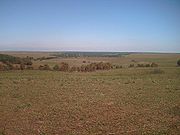
, the county has a total area of 2304 square miles (5,967.3 km²), the largest county in Oklahoma, of which 2251 square miles (5,830.1 km²) is land and 53 square miles (137.3 km²) (2.30%) is water. Most of the county is in the Osage Plains
, and consists of open prairie. The eastern part of the county contains the Osage Hills, an extension of the Flint Hills in Kansas
. Tallgrass Prairie Preserve
is north of Pawhuska.
Gray Horse Creek, Drum Creek and Salt Creek all drain the southwestern part of the county and flow into the Arkansas River
, which is part of the county's southern and western boundaries. Eastern Osage County drains into Caney River
, Bird Creek, Hominy Creek, and Delaware Creek. All of these streams flow into the Verdigris River
.
Lakes and reservoirs in the county include:
It is the most populous and the second-largest geographically (to Corson County, South Dakota
) of the six U.S. counties that lie entirely within an Indian reservation
. (The six counties in descending order of area are Corson County; Osage County; Shannon County, South Dakota
; Todd County, South Dakota; Sioux County, North Dakota
; and Mahnomen County, Minnesota
.) Three other counties, Thurston County, Nebraska
; Dewey County, South Dakota
and Ziebach County, South Dakota
, lie entirely in parts of two separate Indian reservations, for a total of nine counties that lie entirely within reservation territory. Dewey County is also slightly larger than Osage County in area.
of 2000, there were 44,437 people, 16,617 households, and 12,213 families residing in the county. The population density
was 20 people per square mile (8/km²). There were 18,826 housing units at an average density of 8 per square mile (3/km²). The racial makeup of the county was 67.01% White
, 10.84% Black
or African American
, 14.42% Native American
, 0.23% Asian
, 0.03% Pacific Islander
, 0.63% from other races
, and 6.83% from two or more races. 2.12% of the population were Hispanic
or Latino
of any race.
There were 16,617 households out of which 33.20% had children under the age of 18 living with them, 59.40% were married couples
living together, 10.30% had a female householder with no husband present, and 26.50% were non-families. 23.30% of all households were made up of individuals and 10.10% had someone living alone who was 65 years of age or older. The average household size was 2.58 and the average family size was 3.04.
In the county, the population was spread out with 26.40% under the age of 18, 7.70% from 18 to 24, 27.50% from 25 to 44, 25.40% from 45 to 64, and 13.10% who were 65 years of age or older. The median age was 38 years. For every 100 females there were 102.10 males. For every 100 females age 18 and over, there were 100.10 males.
The median income for a household in the county was $34,477, and the median income for a family was $40,784. Males had a median income of $31,148 versus $23,652 for females. The per capita income
for the county was $17,014. About 10.30% of families and 13.20% of the population were below the poverty line, including 17.30% of those under age 18 and 12.10% of those age 65 or over.
:
' play, August: Osage County
(2007), which won the Pulitzer Prize for Drama
and a Tony Award
in 2008.
County (United States)
In the United States, a county is a geographic subdivision of a state , usually assigned some governmental authority. The term "county" is used in 48 of the 50 states; Louisiana is divided into parishes and Alaska into boroughs. Parishes and boroughs are called "county-equivalents" by the U.S...
in the northern part of the U.S. state
U.S. state
A U.S. state is any one of the 50 federated states of the United States of America that share sovereignty with the federal government. Because of this shared sovereignty, an American is a citizen both of the federal entity and of his or her state of domicile. Four states use the official title of...
of Oklahoma
Oklahoma
Oklahoma is a state located in the South Central region of the United States of America. With an estimated 3,751,351 residents as of the 2010 census and a land area of 68,667 square miles , Oklahoma is the 28th most populous and 20th-largest state...
. Coterminous with the Osage Indian Reservation, it is the home of the federally recognized Osage Nation
Osage Nation
The Osage Nation is a Native American Siouan-language tribe in the United States that originated in the Ohio River valley in present-day Kentucky. After years of war with invading Iroquois, the Osage migrated west of the Mississippi River to their historic lands in present-day Arkansas, Missouri,...
. As of the 2010 census, the population was 47,472 a 6.8 percent increase from 2000, when the population was 44,437. Its county seat
County seat
A county seat is an administrative center, or seat of government, for a county or civil parish. The term is primarily used in the United States....
is Pawhuska
Pawhuska, Oklahoma
Pawhuska is a city in and the county seat of Osage County, Oklahoma, United States, and the capital of the Osage Nation. The population was 3,589 at the 2010 census, a decline of 1.2 percent from 3,629 at the 2000 census. The ZIP Code for the city is 74056...
.
History
The Osage of Missouri increased their range to include the present Osage County by 1760. However, they surrendered their claim in 1825 to this land, which was included in a "perpetual outlet to the west given to the Cherokee NationCherokee Nation
The Cherokee Nation is the largest of three Cherokee federally recognized tribes in the United States. It was established in the 20th century, and includes people descended from members of the old Cherokee Nation who relocated voluntarily from the Southeast to Indian Territory and Cherokees who...
by the Treaty of New Echota" in 1835. In 1870, the Osage repurchased 1.57 million acres of this land from the Cherokees. This became the Osage Reservation in 1875, which became part of the Oklahoma Territory
Oklahoma Territory
The Territory of Oklahoma was an organized incorporated territory of the United States that existed from May 2, 1890, until November 16, 1907, when it was joined with the Indian Territory under a new constitution and admitted to the Union as the State of Oklahoma.-Organization:Oklahoma Territory's...
under the Organic Act of 1890. It became a semi-autonomous district by the Enabling Act of 1906 and Osage County at the time of Oklahoma Statehood. The Osage Agency was established at Deep Ford, later renamed as Pawhuska, in 1872.
On December 26, 1861, a band of pro-Union Creeks and Seminoles fought with a Confederate Army unit at the Battle of Chustenahlah on Bird Creek, near the present town of Skiatook
Skiatook, Oklahoma
Skiatook is a town in Osage and Tulsa counties in the U.S. state of Oklahoma. Located in the northeastern part of the state, it is a suburb of Tulsa. The population was 7,397 in the 2010 census, compared to 5,396 at the 2000 census.-History:William C...
.
In October 1897, the Pheonix Oil Company drilled the first successful oil well on the Osage reservation and Oklahoma Territory. It was located along Butler Creek. In 1901, Phoenix Oil and Osage Oil companies combined their assets to form the Indian Territory Illuminating Oil Company (ITIO), which sub-leased the eastern part of the Osage reservation until 1916. When ITIO's lease expired, 160-acre tracts were leased at public auctions.
All subsurface minerals, including oil, are owned by the Osage tribe and held in trust for them by the Federal Government. Each mineral lease was negotiated by the Osage National Council and approved by the U. S. Secretary of the Interior.
During the 1920s, Osage County was the site of the infamous Osage Indian murders
Osage Indian murders
The Osage Indian Murders were a series of murders of Osage Indians in Osage County, Oklahoma, traced to a gang led by William "King of Osage Hills" Hale, with the aim of gaining access to the oil wealth of tribe members....
.
Geography
United States Census Bureau
The United States Census Bureau is the government agency that is responsible for the United States Census. It also gathers other national demographic and economic data...
, the county has a total area of 2304 square miles (5,967.3 km²), the largest county in Oklahoma, of which 2251 square miles (5,830.1 km²) is land and 53 square miles (137.3 km²) (2.30%) is water. Most of the county is in the Osage Plains
Osage Plains
The Osage Plains are a physiographic section of the larger Central Lowland province, which in turn is part of the larger Interior Plains physiographic division. The area is sometimes called the Lower Plains, North Central Plains, and the Rolling Plains...
, and consists of open prairie. The eastern part of the county contains the Osage Hills, an extension of the Flint Hills in Kansas
Kansas
Kansas is a US state located in the Midwestern United States. It is named after the Kansas River which flows through it, which in turn was named after the Kansa Native American tribe, which inhabited the area. The tribe's name is often said to mean "people of the wind" or "people of the south...
. Tallgrass Prairie Preserve
Tallgrass Prairie Preserve
The Tallgrass Prairie Preserve, located in Osage County, Oklahoma near Foraker, Oklahoma, is owned and managed by The Nature Conservancy. It is protected as the largest tract of remaining tallgrass prairie in the world...
is north of Pawhuska.
Gray Horse Creek, Drum Creek and Salt Creek all drain the southwestern part of the county and flow into the Arkansas River
Arkansas River
The Arkansas River is a major tributary of the Mississippi River. The Arkansas generally flows to the east and southeast as it traverses the U.S. states of Colorado, Kansas, Oklahoma, and Arkansas. The river's initial basin starts in the Western United States in Colorado, specifically the Arkansas...
, which is part of the county's southern and western boundaries. Eastern Osage County drains into Caney River
Caney River
The Caney River is a river in southern Kansas and northeastern Oklahoma. The river is a tributary of the Verdigris River, and is usually a flatwater stream....
, Bird Creek, Hominy Creek, and Delaware Creek. All of these streams flow into the Verdigris River
Verdigris River
The Verdigris River is a tributary of the Arkansas River in southeastern Kansas and northeastern Oklahoma in the United States. It is about long...
.
Lakes and reservoirs in the county include:
- Birch LakeBirch Lake (Oklahoma)Birch Lake is a lake near Barnsdall, Oklahoma, Oklahoma.It impounds about of water.It is formed from Birch Creek, which is a tributary of Bird Creek...
- Bluestem Lake
- Hulah Lake
- Kaw LakeKaw LakeKaw Lake is a reservoir completed in 1976 in the northern reaches of the U.S. state of Oklahoma, near Kaw City.Kaw Dam is long and above the stream bed. the dam lies above the mouth of the Arkansas River. The top of the flood control pool is , while the normal operating level is 1,010 feet.The...
- Keystone LakeKeystone LakeKeystone Lake is a reservoir in northeastern Oklahoma on the Arkansas and Cimarron rivers. It is located upstream about from Tulsa. It was created in 1968 when the Keystone Dam was completed.Keystone Lake is about in size...
- Skiatook LakeSkiatook LakeSkiatook Lake is located in Osage County, Oklahoma, 4 miles west of the town of Skiatook, and 11 miles east of Hominy, Oklahoma; about a half hour drive from Tulsa. The Skiatook Dam is located 14 miles upstream of the confluence of Hominy and Bird Creeks...
It is the most populous and the second-largest geographically (to Corson County, South Dakota
Corson County, South Dakota
As of the census of 2000, there were 4,181 people, 1,271 households, and 949 families residing in the county. The population density was 1.7 people per square mile . There were 1,536 housing units at an average density of 0.6 per square mile...
) of the six U.S. counties that lie entirely within an Indian reservation
Indian reservation
An American Indian reservation is an area of land managed by a Native American tribe under the United States Department of the Interior's Bureau of Indian Affairs...
. (The six counties in descending order of area are Corson County; Osage County; Shannon County, South Dakota
Shannon County, South Dakota
As of the census of 2000, there were 12,466 people, 2,785 households, and 2,353 families residing in the county. The population density was 6 people per square mile . There were 3,123 housing units at an average density of 2 per square mile...
; Todd County, South Dakota; Sioux County, North Dakota
Sioux County, North Dakota
-Demographics:As of the census of 2000, there were 4,044 people, 1,095 households, and 871 families residing in the county. The population density was 4 people per square mile . There were 1,216 housing units at an average density of 1 per square mile...
; and Mahnomen County, Minnesota
Mahnomen County, Minnesota
As of the census of 2000, there were 5,190 people, 1,969 households, and 1,366 families residing in the county. The population density was 9 people per square mile . There were 2,700 housing units at an average density of 5 per square mile...
.) Three other counties, Thurston County, Nebraska
Thurston County, Nebraska
-History:Varying cultures of indigenous peoples lived along the rivers for thousands of years before European encounter.Thurston County was organized by European Americans in 1889 from land that had been divided between Dakota and Burt counties since the dissolution of Blackbird County in 1879. It...
; Dewey County, South Dakota
Dewey County, South Dakota
As of the census of 2000, there were 5,972 people, 1,863 households, and 1,386 families residing in the county. The population density was 3 people per square mile . There were 2,133 housing units at an average density of 1 per square mile...
and Ziebach County, South Dakota
Ziebach County, South Dakota
As of the census of 2000, there were 2,519 people, 741 households, and 594 families residing in the county. The population density was 1.3 people per square mile . There were 879 housing units at an average density of 0.4 per square mile...
, lie entirely in parts of two separate Indian reservations, for a total of nine counties that lie entirely within reservation territory. Dewey County is also slightly larger than Osage County in area.
Demographics
As of the censusCensus
A census is the procedure of systematically acquiring and recording information about the members of a given population. It is a regularly occurring and official count of a particular population. The term is used mostly in connection with national population and housing censuses; other common...
of 2000, there were 44,437 people, 16,617 households, and 12,213 families residing in the county. The population density
Population density
Population density is a measurement of population per unit area or unit volume. It is frequently applied to living organisms, and particularly to humans...
was 20 people per square mile (8/km²). There were 18,826 housing units at an average density of 8 per square mile (3/km²). The racial makeup of the county was 67.01% White
Race (United States Census)
Race and ethnicity in the United States Census, as defined by the Federal Office of Management and Budget and the United States Census Bureau, are self-identification data items in which residents choose the race or races with which they most closely identify, and indicate whether or not they are...
, 10.84% Black
Race (United States Census)
Race and ethnicity in the United States Census, as defined by the Federal Office of Management and Budget and the United States Census Bureau, are self-identification data items in which residents choose the race or races with which they most closely identify, and indicate whether or not they are...
or African American
Race (United States Census)
Race and ethnicity in the United States Census, as defined by the Federal Office of Management and Budget and the United States Census Bureau, are self-identification data items in which residents choose the race or races with which they most closely identify, and indicate whether or not they are...
, 14.42% Native American
Race (United States Census)
Race and ethnicity in the United States Census, as defined by the Federal Office of Management and Budget and the United States Census Bureau, are self-identification data items in which residents choose the race or races with which they most closely identify, and indicate whether or not they are...
, 0.23% Asian
Race (United States Census)
Race and ethnicity in the United States Census, as defined by the Federal Office of Management and Budget and the United States Census Bureau, are self-identification data items in which residents choose the race or races with which they most closely identify, and indicate whether or not they are...
, 0.03% Pacific Islander
Race (United States Census)
Race and ethnicity in the United States Census, as defined by the Federal Office of Management and Budget and the United States Census Bureau, are self-identification data items in which residents choose the race or races with which they most closely identify, and indicate whether or not they are...
, 0.63% from other races
Race (United States Census)
Race and ethnicity in the United States Census, as defined by the Federal Office of Management and Budget and the United States Census Bureau, are self-identification data items in which residents choose the race or races with which they most closely identify, and indicate whether or not they are...
, and 6.83% from two or more races. 2.12% of the population were Hispanic
Race (United States Census)
Race and ethnicity in the United States Census, as defined by the Federal Office of Management and Budget and the United States Census Bureau, are self-identification data items in which residents choose the race or races with which they most closely identify, and indicate whether or not they are...
or Latino
Race (United States Census)
Race and ethnicity in the United States Census, as defined by the Federal Office of Management and Budget and the United States Census Bureau, are self-identification data items in which residents choose the race or races with which they most closely identify, and indicate whether or not they are...
of any race.
There were 16,617 households out of which 33.20% had children under the age of 18 living with them, 59.40% were married couples
Marriage
Marriage is a social union or legal contract between people that creates kinship. It is an institution in which interpersonal relationships, usually intimate and sexual, are acknowledged in a variety of ways, depending on the culture or subculture in which it is found...
living together, 10.30% had a female householder with no husband present, and 26.50% were non-families. 23.30% of all households were made up of individuals and 10.10% had someone living alone who was 65 years of age or older. The average household size was 2.58 and the average family size was 3.04.
In the county, the population was spread out with 26.40% under the age of 18, 7.70% from 18 to 24, 27.50% from 25 to 44, 25.40% from 45 to 64, and 13.10% who were 65 years of age or older. The median age was 38 years. For every 100 females there were 102.10 males. For every 100 females age 18 and over, there were 100.10 males.
The median income for a household in the county was $34,477, and the median income for a family was $40,784. Males had a median income of $31,148 versus $23,652 for females. The per capita income
Per capita income
Per capita income or income per person is a measure of mean income within an economic aggregate, such as a country or city. It is calculated by taking a measure of all sources of income in the aggregate and dividing it by the total population...
for the county was $17,014. About 10.30% of families and 13.20% of the population were below the poverty line, including 17.30% of those under age 18 and 12.10% of those age 65 or over.
Cities and towns
|
Foraker, Oklahoma Foraker is a town in Osage County, Oklahoma, United States. It was named for Ohio Senator James B. Foraker. The Tallgrass Prairie Preserve is southeast of town. The official population peaked at 415 in 1910 and has declined steadily since 1930... Grainola, Oklahoma Grainola is a town in Osage County, Oklahoma in the United States. The population was 31 at the 2010 census, unchanged from the 2000 census. The main industry of the area is cattle ranching.-Geography:Grainola is located at .... Hominy, Oklahoma Hominy is a city in Osage County, Oklahoma, United States. The population was 3,565 at the 2010 census, a 38 percent increase from 2,584 at the 2000 census.-Geography:Hominy is located at .... Osage, Oklahoma Osage is a town in Osage County, Oklahoma, United States. The population was 156 at the 2010 census, down 17 percent from 188 at the 2000 census.-Geography:Osage is located at .... |
Pawhuska, Oklahoma Pawhuska is a city in and the county seat of Osage County, Oklahoma, United States, and the capital of the Osage Nation. The population was 3,589 at the 2010 census, a decline of 1.2 percent from 3,629 at the 2000 census. The ZIP Code for the city is 74056... Prue, Oklahoma Prue is a town in Osage County, Oklahoma, United States. The population was 465 at the United States Census, 2010, up 7.4 percent from 433 at the 2000 census.-Geography:Prue is located at .... Sand Springs, Oklahoma Sand Springs is a city in Osage and Tulsa counties in the U.S. state of Oklahoma. A suburb of Tulsa, it is located predominantly in Tulsa County. The population was 18,906 in the 2010 U. S. Census, compared to 17,451 at the 2000 census. The city was founded in 1911, by Oklahoma philanthropist... †† Shidler, Oklahoma Shidler is a city in Osage County, Oklahoma, United States. The population was 441 at the 2010 census, a 15.2 percent decrease from 520 at the 2000 census.-Geography:Shidler is located at .... Skiatook, Oklahoma Skiatook is a town in Osage and Tulsa counties in the U.S. state of Oklahoma. Located in the northeastern part of the state, it is a suburb of Tulsa. The population was 7,397 in the 2010 census, compared to 5,396 at the 2000 census.-History:William C... ††† |
Tulsa, Oklahoma Tulsa is the second-largest city in the state of Oklahoma and 46th-largest city in the United States. With a population of 391,906 as of the 2010 census, it is the principal municipality of the Tulsa Metropolitan Area, a region with 937,478 residents in the MSA and 988,454 in the CSA. Tulsa's... †† Webb City, Oklahoma Webb City is a small town in Osage County, Oklahoma, United States. The population was 62 at the 2010 census, a 34.7 percent decline from 95 at the 2000 census. It was named for its founder, Horrace Webb.-History:... Wynona, Oklahoma Wynona is a town in Osage County, Oklahoma, United States. The population was 437 at the 2010 census, a 17.7 percent decline from 531 at the 2000 census.-Geography:Wynona is located at .... |
- † Bartlesville is primarily in Washington CountyWashington County, OklahomaWashington County is a county located in the U.S. state of Oklahoma. It is, in total area, the smallest county in Oklahoma, adjacent to the largest county in Oklahoma, Osage County. It is the second smallest county, by land only size, i.e., not including water. As of 2000, the population was...
, but part of it extends into Osage County. - †† Sand Springs and Tulsa are primarily in Tulsa CountyTulsa County, OklahomaTulsa County is a county located in the U.S. state of Oklahoma. According to the 2010 U.S. Census, the population is 603,403. Its county seat is Tulsa.-History of Tulsa County:The history of Tulsa County greatly overlaps the history of the city of Tulsa...
, but parts of them extend into Osage County. - ††† Skiatook is primarily in Osage County, but part of it extends into Tulsa County.
NRHP sites
The following sites in Osage County are listed on the National Register of Historic PlacesNational Register of Historic Places
The National Register of Historic Places is the United States government's official list of districts, sites, buildings, structures, and objects deemed worthy of preservation...
:
|
Osage Bank of Fairfax The Osage Bank of Fairfax was the first bank building built in Osage County. It was built in 1904, at the time of the Oklahoma oil boom. It is one of four small bank buildings built in Richardsonian Romanesque style in Osage County, Oklahoma during 1904-1911... , Fairfax |
Adjacent counties
- Cowley County, KansasCowley County, KansasCowley County is a county located in south-central Kansas, in the Central United States. As of the 2010 census, the county population was 36,311. Its county seat and most populous city is Winfield...
(north) - Chautauqua County, KansasChautauqua County, KansasChautauqua County is a county located in Southeast Kansas, in the Central United States. As of the 2010 census, the county population was 3,669. Its county seat and most populous city is Sedan...
(northeast) - Washington CountyWashington County, OklahomaWashington County is a county located in the U.S. state of Oklahoma. It is, in total area, the smallest county in Oklahoma, adjacent to the largest county in Oklahoma, Osage County. It is the second smallest county, by land only size, i.e., not including water. As of 2000, the population was...
(east) - Tulsa CountyTulsa County, OklahomaTulsa County is a county located in the U.S. state of Oklahoma. According to the 2010 U.S. Census, the population is 603,403. Its county seat is Tulsa.-History of Tulsa County:The history of Tulsa County greatly overlaps the history of the city of Tulsa...
(southeast) - Pawnee CountyPawnee County, OklahomaPawnee County is a county located in the U.S. state of Oklahoma. As of 2000, the population was 16,612. Its county seat is Pawnee.-History:The Osage Tribe used the area that contains present day Pawnee County as buffalo hunting grounds...
& Noble CountyNoble County, OklahomaNoble County is a county located in the U.S. state of Oklahoma. As of 2010, the population was 11,561. Its county seat is Perry.-21st century:In 2010, the Keystone-Cushing Pipeline was constructed north to south through Noble County....
(southwest) - Kay CountyKay County, OklahomaKay County is a county located in the U.S. state of Oklahoma. As of 2000, the population was 48,080. Its county seat is Newkirk. The largest city in Kay County is Ponca City.-19th century:...
(west)
Popular culture
It is the setting of Oklahoma native Tracy LettsTracy Letts
Tracy Letts is an American playwright and actor who received the 2008 Pulitzer Prize for Drama for his play August: Osage County.-Biography:...
' play, August: Osage County
August: Osage County
August: Osage County is a darkly comedic play by Tracy Letts. It was the recipient of the 2008 Pulitzer Prize for Drama. The play premiered at the Steppenwolf Theatre in Chicago on 28 June 2007, and closed on 26 August 2007. Its Broadway debut was at the Imperial Theater on 4 December 2007 and...
(2007), which won the Pulitzer Prize for Drama
Pulitzer Prize for Drama
The Pulitzer Prize for Drama was first awarded in 1918.From 1918 to 2006, the Drama Prize was unlike the majority of the other Pulitzer Prizes: during these years, the eligibility period for the drama prize ran from March 2 to March 1, to reflect the Broadway 'season' rather than the calendar year...
and a Tony Award
Tony Award
The Antoinette Perry Award for Excellence in Theatre, more commonly known as a Tony Award, recognizes achievement in live Broadway theatre. The awards are presented by the American Theatre Wing and The Broadway League at an annual ceremony in New York City. The awards are given for Broadway...
in 2008.
See also
- August: Osage CountyAugust: Osage CountyAugust: Osage County is a darkly comedic play by Tracy Letts. It was the recipient of the 2008 Pulitzer Prize for Drama. The play premiered at the Steppenwolf Theatre in Chicago on 28 June 2007, and closed on 26 August 2007. Its Broadway debut was at the Imperial Theater on 4 December 2007 and...
(play)