
Omsk Metro
Encyclopedia
Omsk
-History:The wooden fort of Omsk was erected in 1716 to protect the expanding Russian frontier along the Ishim and the Irtysh rivers against the Kyrgyz nomads of the Steppes...
, Russia
Russia
Russia or , officially known as both Russia and the Russian Federation , is a country in northern Eurasia. It is a federal semi-presidential republic, comprising 83 federal subjects...
. After long delays, the first section is scheduled to open in 2016, which will make it Siberia's second metropolitan underground railway system after the Novosibirsk Metro
Novosibirsk Metro
-History:Novosibirsk is the third largest city of Russia, with a population of 1.4 million people. It was founded as a junction city between the main transfer arteries in Siberia, the Trans-Siberian railway and the Ob River. Thus, it was not a surprise that the city grew very quickly...
system that was opened in the mid 1980s.
History
Central planners in MoscowMoscow
Moscow is the capital, the most populous city, and the most populous federal subject of Russia. The city is a major political, economic, cultural, scientific, religious, financial, educational, and transportation centre of Russia and the continent...
first identified Omsk as a metro-eligible city during the 1960s, due to its length along the Irtysh River and its relatively narrow streets. But after the plan was approved and financed, the planners decided to build an express tram instead, and the money allocated to Omsk was given to Chelyabinsk
Chelyabinsk
Chelyabinsk is a city and the administrative center of Chelyabinsk Oblast, Russia, located in the northwestern side of the oblast, south of Yekaterinburg, just to the east of the Ural Mountains, on the Miass River. Population: -History:...
. In 1979, a Gosplan
Gosplan
Gosplan or State Planning Committee was the committee responsible for economic planning in the Soviet Union. The word "Gosplan" is an abbreviation for Gosudarstvenniy Komitet po Planirovaniyu...
commission rejected a plan to build an express tram system since it was predicted to be unable to handle projected passenger flows without severely discomforting riders. In 1986, metro plans were revisited and financing began, along with the demolition of residential buildings to make way for tracks and a yard.
Construction began in 1992 between the stations Tupolevskaya and Rabochaya . The initial plans involved opening the section between the stations Marshala Zhukova and Rabochaya on the right bank of the Irtysh River to connect downtown to the manufacturing district, and then later to connect the line to the opposite bank of the Irtysh. Due to poor financial circumstances, by 2003 just the section between Tupolevskaya and Rabochaya was completed (with no intermediate stations). At this time the plans changed and the authorities decided to connect the two banks of the Irtsh with a metro bridge, going between one station on the right bank and three on the left bank. The combined metro (lower level) and motor-vehicle
Motor vehicle
A motor vehicle or road vehicle is a self-propelled wheeled vehicle that does not operate on rails, such as trains or trolleys. The vehicle propulsion is provided by an engine or motor, usually by an internal combustion engine, or an electric motor, or some combination of the two, such as hybrid...
(upper level) bridge was built and opened to vehicular traffic in 2005.
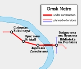
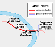
The current phase of construction involves four stations:
- Biblioteka Imeni Pushkina ( ~ Pushkin Library)
- Zarechnaya ( ~ Over the River)
- Kristall
- Sobornaya ( ~ Cathedral Station)
This section is 6.1 km in length. The average speed is expected to be 36 km/h and travel time along the entire route is expected to be 10 minutes 12 seconds. Daily ridership is projected at 190,000 passengers and yearly ridership at 69 million.
Stations
All of the stations will be shallow.- Biblioteka Imeni Pushkina was planned as Krasny Put' ( ~ Red Way).
- Kristall was planned as Bulvar Arkhitektorov ( ~ Boulevard of the Architects)
- Sobornaya was planned as Avtovokzal ( ~ Bus Terminal).
Future development
Plans call for the line to be extended on the right bank of the Irtysh to Rabochaya station (the section between Tupolevskaya and Rabochaya is partially complete). The first line is planned to have 11 stations and a total length of 13.6 km, with an additional metro bridge over the Om RiverOm River
Om is a river in the south of Western Siberian plains in Russia. It is ~724 km long, flowing into the major Irtysh River. It rises in the Vasyugan Swamp at the border of Novosibirsk and Omsk oblasts....
, by 2015 or 2016 (the latter date is the 300th anniversary of Omsk). When the line is complete, it is expected to have a daily ridership of 330,000 passengers.
Construction of the second line will start after 2015. It will go on the right bank of the Irtysh, mostly parallel to the river. Transfer to the first line will be available at Biblioteka Imeni Pushkina. This line is expected to have twenty stations. At the same time, the first line is planned to be extended on the left bank by four stations.
The third line will not be built until the distant future. If built, it will likely be on both banks of the Irtysh, like the first line.