
Oliver Paipoonge, Ontario
Encyclopedia
Township (Canada)
The term township generally means the district or area associated with a town. However in some systems no town needs to be involved. The specific use of the term to describe political subdivisions has varied by country, usually to describe a local rural or semi-rural government within the county...
in the Canadian
Canada
Canada is a North American country consisting of ten provinces and three territories. Located in the northern part of the continent, it extends from the Atlantic Ocean in the east to the Pacific Ocean in the west, and northward into the Arctic Ocean...
province of Ontario
Ontario
Ontario is a province of Canada, located in east-central Canada. It is Canada's most populous province and second largest in total area. It is home to the nation's most populous city, Toronto, and the nation's capital, Ottawa....
, located directly west of the city of Thunder Bay
Thunder Bay
-In Canada:Thunder Bay is the name of three places in the province of Ontario, Canada along Lake Superior:*Thunder Bay District, Ontario, a district in Northwestern Ontario*Thunder Bay, a city in Thunder Bay District*Thunder Bay, Unorganized, Ontario...
. The municipality was formed on January 1, 1998, with the amalgamation of the former Township of Oliver and Township of Paipoonge. It contains several communities within its boundaries, including Baird, Carters Corners, Harstone, Kakabeka Falls, Lee, McCluskeys Corners, Millar, Murillo, Rosslyn, Slate River Valley, Stanley and Twin City. The remainder of the municipality is agricultural or rural.
The municipality is part of Thunder Bay's Census Metropolitan Area.
Geography
The geography of Oliver Paipoonge transitions from river valleys in the south, through flat open farmland and rolling hills in the central areas, to the rough Canadian ShieldCanadian Shield
The Canadian Shield, also called the Laurentian Plateau, or Bouclier Canadien , is a vast geological shield covered by a thin layer of soil that forms the nucleus of the North American or Laurentia craton. It is an area mostly composed of igneous rock which relates to its long volcanic history...
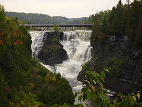
in the north. The most notable geographic feature is Kakabeka Falls
Kakabeka Falls
Kakabeka Falls Provincial Park, established in 1955, covers 5 km² and is managed by Ontario Parks. It surrounds the falls and extends along the Kaministiquia River, which was used centuries ago by Voyageurs, who were the first Europeans to overwinter annually in northern Ontario...
, located on the western edge of the municipality in Kakabeka Falls Provincial Park.
Communities
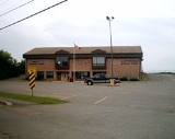
Murillo contains a post office, two stores, the Murillo Bakery featuring Rye Breads, a municipal hall, and a tavern. New commercial enterprises, located in the Rubin Industrial Park, include a well driller, self-storage facility, a forest products manufacturer, and the Rural Roots child care facility. Each year the village hosts the Murillo Fall Fair, which features chariot races.The village is the location of the government offices for the Municipality of Oliver Paipoonge as well as the Oliver Paipoonge Police and the Lakehead Rural Planning Board.
Murillo was originally a water stop
Water stop
A water stop or water station on a railroad is a place where trains stop to replenish water. The stopping of the train itself is also referred to as "water stop". The term originates from the times of steam engines, when large amounts of water were essential...
on the Canadian Pacific Railway (CPR). The stop was named after the Spanish painter Bartolomé Estéban Murillo
Bartolomé Estéban Murillo
Bartolomé Esteban Murillo was a Spanish Baroque painter. Although he is best known for his religious works, Murillo also produced a considerable number of paintings of contemporary women and children...
, as the CPR was at that time using the names of painters to name the many new communities springing up along its trans-Canadian line.
Rosslyn contains numerous commercial enterprises and is home to approximately 1,000 people and the Paipoonge Museum. A new golf
Golf
Golf is a precision club and ball sport, in which competing players use many types of clubs to hit balls into a series of holes on a golf course using the fewest number of strokes....
course and housing subdivision, named King George's Park, are currently being developed in a former gravel
Gravel
Gravel is composed of unconsolidated rock fragments that have a general particle size range and include size classes from granule- to boulder-sized fragments. Gravel can be sub-categorized into granule and cobble...
pit. There is also a skating rink here, and a community centre beside it.
Kakabeka Falls takes its name from the nearby Kakabeka Falls
Kakabeka Falls
Kakabeka Falls Provincial Park, established in 1955, covers 5 km² and is managed by Ontario Parks. It surrounds the falls and extends along the Kaministiquia River, which was used centuries ago by Voyageurs, who were the first Europeans to overwinter annually in northern Ontario...
waterfall. The Lauber Arboretum
Lauber Arboretum
Lauber Arboretum is an arboretum located in Kakabeka Falls, Ontario. It has been developed privately by Mr. and Mrs. Bert Sitch. The arboretum includes many indigenous species, along with twenty-odd species non-indigenous to the area, which the Sitches have collected on their travels...
is located in the community.
As Kakabeka Falls' economy is based on tourism, its main street is lined with tourist oriented businesses such as hotels, restaurants, and camping sites. A three-day street fair
Street fair
A street fair is a fair that celebrates the character of a neighborhood. As its name suggests, it is usually held on the main street of a neighborhood....
is hosted in the village every August. Kakabeka Falls has a public school, called Kakabeka Falls Elementary School, located on the community's main street.
Population and demographics
According to the 2001 census, there were 5,862 people residing in Oliver Paipoonge, of whom 51.2% were male and 48.8% were female. Children under five accounted for approximately 4.9% of the resident population of Oliver Paipoonge. This compares with 5.8% in Ontario as a whole, and almost 5.6% for Canada overall.In mid-2001, 9.7% of the resident population in Oliver Paipoonge were of retirement age (65 and over for males and females) compared with 13.2% in Canada. The average age is 37.9 years of age comparing to 37.6 years of age for all of Canada.
In the five years between 1996 and 2001, the population of Oliver Paipoonge declined by 0.8% compared with an increase of 6.1% for Ontario province as a whole. Population density of Oliver Paipoonge averaged 16.7 people per square kilometre, compared with an average of 12.6 for Ontario altogether.
Population trend:
- Population in 2006: 5757 (2001 to 2006 population change: -1.8 %)
- Population in 2001: 5862
- Population total in 1996: 5907
- Oliver (township): 2711
- Paipoonge (township): 3196
- Population in 1991:
- Oliver (township): 2462
- Paipoonge (township): 2972
Religion
The 2001 census states that 81.2 per cent of Oliver Paipoonge residents belong to a ChristianChristian
A Christian is a person who adheres to Christianity, an Abrahamic, monotheistic religion based on the life and teachings of Jesus of Nazareth as recorded in the Canonical gospels and the letters of the New Testament...
(28.5% Roman Catholic, 50.1% Protestant, and 2.6% other Christian, mostly Orthodox
Eastern Orthodox Church
The Orthodox Church, officially called the Orthodox Catholic Church and commonly referred to as the Eastern Orthodox Church, is the second largest Christian denomination in the world, with an estimated 300 million adherents mainly in the countries of Belarus, Bulgaria, Cyprus, Georgia, Greece,...
) denomination. Those who follow religions like Buddhism
Buddhism
Buddhism is a religion and philosophy encompassing a variety of traditions, beliefs and practices, largely based on teachings attributed to Siddhartha Gautama, commonly known as the Buddha . The Buddha lived and taught in the northeastern Indian subcontinent some time between the 6th and 4th...
, Judaism
Judaism
Judaism ) is the "religion, philosophy, and way of life" of the Jewish people...
, Islam
Islam
Islam . The most common are and . : Arabic pronunciation varies regionally. The first vowel ranges from ~~. The second vowel ranges from ~~~...
, Baha'i, and others make up 1.5% of the population combined, while the remaining 17.3% are non-religious.
Transportation
The municipality is served by three major highways. Highways 61Ontario Highway 61
King's Highway 61, commonly referred to as Highway 61 and historically known as the Scott Highway, is a provincially maintained highway in the Canadian province of Ontario. It connects the Pigeon River Bridge, where it crosses into the United States and becomes Minnesota State Highway 61, with a...
and 130 are located in the southeast corner of the municipality and serves as the backbone of the Slate River Valley, an agricultural community. Highway 130 connects to the Trans-Canada Highway
Trans-Canada Highway
The Trans-Canada Highway is a federal-provincial highway system that joins the ten provinces of Canada. It is, along with the Trans-Siberian Highway and Australia's Highway 1, one of the world's longest national highways, with the main route spanning 8,030 km...
(Highway 11/17) at Rosslyn, the largest settlement. It also serves as the main street for Kakabeka Falls. Approximately half of the population of Oliver Paipoonge lives within five kilometres of Highway 11/17. Highway 102 runs through the northeast corner of the municipality.
A small grass airstrip is located northeast of Kakabeka Falls, and two rail lines run through the municipality.
Economy
Oliver Paipoonge's primary industry is agriculture, followed with tourism focused around Kakabeka Falls and forest products manufacturing in Murillo and Rosslyn. Many residents commute to work either to Thunder Bay or the surrounding woodlands.Politics
The municipal office of Oliver Paipoonge is located in the village of Murillo. The current mayor of Oliver Paipoonge is Lucia Kloosterhuis; first elected as mayor in 2003, having previously served as a councillor in both Oliver Paipoonge and the former Township of Paipoonge. The first female elected as mayor in Oliver Township was Iris Calvert, in 1991. Previously, the Municipality of Paipoonge had not elected a female as mayor.Sites of interest
Each year Kakabeka Falls hosts a street fair, Murillo hosts the Murillo Fall Fair, the Slate River area hosts the Slate River Ploughing Match, and the Agriplex hosts an annual summer fair.There are two museums in the municipality: the Paipoonge Museum in Rosslyn and the Pioneer Museum in the Slate River Valley.
Education
Oliver Paipoonge is served by the Lakehead District School BoardLakehead District School Board
The Lakehead District School Board oversees all secular English-language public schools in the Thunder Bay CMA and the townships of Gorham and Ware in Ontario, Canada. It administers education at 22 elementary schools, 4 secondary schools and an adult education centre.Elementary Schools*Agnew H....
. There are four schools located in Oliver Paipoonge, Crestview Public School in Murillo, Kakabeka Falls Public School in Kakabeka Falls, Valley Central Public School and Thunder Bay Christian School (JK - Grade 10). High schools students are bused to Thunder Bay. A daycare centre is located in Murillo.