

Ohio State Highway 253
Encyclopedia
State Route 253 is a very short east–west state highway
in the southern part of the U.S. state
of Ohio
. With an overall length of just 0.56 mile (0.9012304 km), the majority of SR 253 is a part of the Jesse Stuart Memorial Bridge
, which crosses over the Ohio River
near Franklin Furnace
. The western terminus of SR 253 is at about the midspan of the bridge, where it crosses the Kentucky
State Line and becomes Kentucky Route 10 (KY 10). The eastern terminus of the highway is at a diamond interchange
with U.S. Route 52 (US 52) near the eastern landing of the Ohio River crossing. The current SR 253 was established in the late 1980s. However, an earlier version of the highway existed in the Medina
vicinity from the early 1920s until the late 1950s.
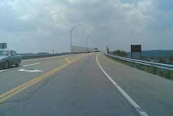
in southeastern Scioto County
, near the community of Franklin Furnace. This short highway starts at the Kentucky state line on the two-lane Jesse Stuart Memorial Bridge over the Ohio River, at the very point where KY 10 terminates. The highway departs the bridge to the east. After a short distance, it then crosses a shorter bridge over the Norfolk Southern Railway
line. Right at the east end of that bridge, SR 253 comes to an end at a diamond interchange it has with the US 52 expressway. East of the interchange is a short connector to Scioto County Road 1, which runs parallel to US 52 to the east through this area.
On a regular basis, the Ohio Department of Transportation
(ODOT) conducts surveys to measure the amount of traffic that uses its highway system. These traffic counts are commonly given in terms of average annual daily traffic (AADT), a determination of the number of vehicles on a particular segment of roadway on any typical day of the year. A traffic count by ODOT in 2008 showed that 7,210 cars and 710 trucks utilized SR 253 on a daily basis. The entirety of SR 253 is included within the National Highway System
, a system of routes deemed most important for the economy, mobility and defense of the country.
concurrency and U.S. Route 42 was brought into the state highway system. This roadway, which is located less than 1 miles (1.6 km) north of the city limits
of Medina, was given the designation of SR 253. In 1937, the route was extended east along Fenn Road to a new eastern terminus at SR 3 northeast of Medina. SR 253's time of being routed along this stretch of roadway came to an end in 1958 when jurisdiction of Fenn Road was transferred from the state to Medina County.
By 1989, SR 253 was re-introduced to the state highway system. Coinciding with the completion of the Jesse Stuart Memorial Bridge across the Ohio River, the designation was applied to the brief alignment that it maintains to this day from the Kentucky state line on the bridge to the US 52 expressway.
State highway
State highway, state road or state route can refer to one of three related concepts, two of them related to a state or provincial government in a country that is divided into states or provinces :#A...
in the southern part of the U.S. state
U.S. state
A U.S. state is any one of the 50 federated states of the United States of America that share sovereignty with the federal government. Because of this shared sovereignty, an American is a citizen both of the federal entity and of his or her state of domicile. Four states use the official title of...
of Ohio
Ohio
Ohio is a Midwestern state in the United States. The 34th largest state by area in the U.S.,it is the 7th‑most populous with over 11.5 million residents, containing several major American cities and seven metropolitan areas with populations of 500,000 or more.The state's capital is Columbus...
. With an overall length of just 0.56 mile (0.9012304 km), the majority of SR 253 is a part of the Jesse Stuart Memorial Bridge
Jesse Stuart Memorial Bridge
The Jesse Stuart Memorial Bridge is a viaduct on top of the Greenup Locks and Dam on the Ohio River. The bridge, named after author and Greenup County, Kentucky native Jesse Stuart, was completed in 1984 and carries Kentucky Route 10 from the AA Highway/U.S. 23 intersection to the bridge itself,...
, which crosses over the Ohio River
Ohio River
The Ohio River is the largest tributary, by volume, of the Mississippi River. At the confluence, the Ohio is even bigger than the Mississippi and, thus, is hydrologically the main stream of the whole river system, including the Allegheny River further upstream...
near Franklin Furnace
Franklin Furnace
Franklin Furnace, also known as the Franklin Mine, is a famous mineral location for rare zinc, iron, manganese minerals in old mines in Franklin, New Jersey, USA. This locale produced more species of minerals and more different fluorescent minerals than any other location...
. The western terminus of SR 253 is at about the midspan of the bridge, where it crosses the Kentucky
Kentucky
The Commonwealth of Kentucky is a state located in the East Central United States of America. As classified by the United States Census Bureau, Kentucky is a Southern state, more specifically in the East South Central region. Kentucky is one of four U.S. states constituted as a commonwealth...
State Line and becomes Kentucky Route 10 (KY 10). The eastern terminus of the highway is at a diamond interchange
Diamond interchange
A diamond interchange is a common type of road junction, used where a freeway crosses a minor road. The freeway itself is grade-separated from the minor road, one crossing the other over a bridge...
with U.S. Route 52 (US 52) near the eastern landing of the Ohio River crossing. The current SR 253 was established in the late 1980s. However, an earlier version of the highway existed in the Medina
Medina, Ohio
In the city the population was spread out with 29.9% under the age of 18, 7.2% from 18 to 24, 33.8% from 25 to 44, 18.8% from 45 to 64, and 10.2% who were 65 years of age or older. The median age was 33 years. For every 100 females there were 92.1 males...
vicinity from the early 1920s until the late 1950s.
Route description
SR 253 runs exclusively within Green TownshipGreen Township, Scioto County, Ohio
Green Township is one of the sixteen townships of Scioto County, Ohio, United States. The 2000 census found 4,079 people in the township.-Geography:Located in the far south of the county along the Ohio River, it borders the following townships:...
in southeastern Scioto County
Scioto County, Ohio
As of the census of 2000, there were 79,195 people, 30,871 households, and 21,362 families residing in the county. The population density was 129 people per square mile . There were 34,054 housing units at an average density of 56 per square mile...
, near the community of Franklin Furnace. This short highway starts at the Kentucky state line on the two-lane Jesse Stuart Memorial Bridge over the Ohio River, at the very point where KY 10 terminates. The highway departs the bridge to the east. After a short distance, it then crosses a shorter bridge over the Norfolk Southern Railway
Norfolk Southern Railway
The Norfolk Southern Railway is a Class I railroad in the United States, owned by the Norfolk Southern Corporation. With headquarters in Norfolk, Virginia, the company operates 21,500 route miles in 22 eastern states, the District of Columbia and the province of Ontario, Canada...
line. Right at the east end of that bridge, SR 253 comes to an end at a diamond interchange it has with the US 52 expressway. East of the interchange is a short connector to Scioto County Road 1, which runs parallel to US 52 to the east through this area.
On a regular basis, the Ohio Department of Transportation
Ohio Department of Transportation
The Ohio Department of Transportation is the organization of state government responsible for developing and maintaining all state and federal roadways in the state of Ohio with exception of the Ohio Turnpike. In addition to highways, the department also helps develop public transportation and...
(ODOT) conducts surveys to measure the amount of traffic that uses its highway system. These traffic counts are commonly given in terms of average annual daily traffic (AADT), a determination of the number of vehicles on a particular segment of roadway on any typical day of the year. A traffic count by ODOT in 2008 showed that 7,210 cars and 710 trucks utilized SR 253 on a daily basis. The entirety of SR 253 is included within the National Highway System
National Highway System (United States)
The National Highway System is a network of strategic highways within the United States, including the Interstate Highway System and other roads serving major airports, ports, rail or truck terminals, railway stations, pipeline terminals and other strategic transport facilities.Individual states...
, a system of routes deemed most important for the economy, mobility and defense of the country.
History
The SR 253 designation has been utilized on two separate occasions. The first iteration of the highway began in 1925. At the time, in the northern half of Medina County, a segment of what is now county-maintained Fenn Road between the SR 18/SR 57Ohio State Route 57
State Route 57 is a north–south state highway in northeast Ohio. Route 57 runs south from U.S. Route 6 in Lorain to U.S. Route 30 at Riceland, a distance of .- Route description :...
concurrency and U.S. Route 42 was brought into the state highway system. This roadway, which is located less than 1 miles (1.6 km) north of the city limits
City limits
The terms city limits and city boundary refer to the defined boundary or border of a city. The area within the city limits is sometimes called the city proper. The terms town limits/boundary and village limits/boundary mean the same as city limits/boundary, but apply to towns and villages...
of Medina, was given the designation of SR 253. In 1937, the route was extended east along Fenn Road to a new eastern terminus at SR 3 northeast of Medina. SR 253's time of being routed along this stretch of roadway came to an end in 1958 when jurisdiction of Fenn Road was transferred from the state to Medina County.
By 1989, SR 253 was re-introduced to the state highway system. Coinciding with the completion of the Jesse Stuart Memorial Bridge across the Ohio River, the designation was applied to the brief alignment that it maintains to this day from the Kentucky state line on the bridge to the US 52 expressway.