
Northeastern United States tornado outbreak of 1989
Encyclopedia
The 1989 Northeastern United States tornado outbreak was a series of tornado
es which caused more than $130 million (1989 USD
) in damage across the Northeastern United States
on July 10, 1989. The storm system affected five states with severe weather
, including hail
up to 2.5 inches (6.4 cm) across, thunderstorm winds up to 90 mph (150 km/h), and 17 tornadoes. Several towns in New York
and Connecticut
were particularly hard-hit. Several homes were leveled in Greenville, New York
and extensive damage occurred in Bantam, Connecticut
. A large section of Hamden, Connecticut
, including an industrial park and hundreds of homes, was completely destroyed; in some places buildings were flattened to the ground.
More than 150 people were injured by the tornado outbreak
, and one person was killed by thunderstorm winds. While tornado outbreaks in this area are unusual, this storm was especially rare in that it produced six significant tornadoes, two of which were violent F4
s, and featured many tornadoes with tracks of several miles.
 Storms began causing damage early in the morning on July 10, 1989. A tornado briefly touched down in Ogdensburg, New York
at 5AM, injuring one person. Hail up to 1 in (25 mm) wide, wind gusts over 50 mph (60 km/h), and many reports of wind damage were reported in New York, Vermont
, and Massachusetts before noon. Severe weather
is an unusual occurrence in the morning, and the activity only increased in severity towards the middle of the afternoon.
archives say that it was a single tornado, it was likely three or more tornadoes, each producing F3 to F4 damage. Only damage near Greenville was at the F4 level, and some sources doubt it even reached that intensity at all.
The first tornado touched down three miles east of Ames
at 1:27PM, moving southeast. It passed near or through the towns of Carlisle
, Howe Caverns
, Central Bridge, and Schoharie
before lifting. Continuing southeast for 10 miles, the storm produced another tornado briefly near Rensselaerville
. After another 10 miles, a third tornado touched down between Greenville
and Surprise. This final section of the path is plotted as a skipping tornado
, but may have been three or more separate tornadoes.
. The first tornado, which may have been three separate tornadoes, started its path of destruction in Cornwall
, leveling a virgin forest
known as Cathedral Pines
. At the nearby Mohawk Mountain Ski Area
, every ski lift
was destroyed, with some lift chairs found miles away. The tornado continued south-southeast
through Milton, leveling hundreds more trees, and destroyed the village of Bantam
before dissipating. Strong downburst
winds continued to cause damage and level trees after this tornado lifted: it was during this period between tornadoes that a 12-year-old girl was killed by falling trees in Black Rock State Park
.
Soon afterwards, another tornado touched down in Watertown
, passing through Oakville
and northern Waterbury
, damaging or destroying 150 homes.
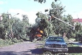
The Hamden tornado was by far the most destructive tornado of this family, and possibly the most damaging of the entire outbreak. It touched down at 5:38 pm near the Wilbur Cross Parkway
. Industrial cranes and cars were tossed through the air, and rows of houses, as well as an industrial park, were flattened. The tornado lifted just a few minutes later at 5:45. The damage path was only five miles long, stopping just short of the city of New Haven, but it damaged or destroyed almost 400 structures in its path.
The storm was so intense at this point that an 80 mph (130 km/h) wind gust was measured in downtown New Haven after the tornado dissipated. About the same time, a tornado struck the area between Carmel and Brewster, New York
, unroofing a condominium
complex. Five people were injured.
. An F2 tornado caused significant damage in the town of East Moriches
. A man was thrown with his trailer across an airfield; he escaped the destroyed trailer with only minor injuries. The tornado was accompanied by 2.5 inch (6.4 cm) hail. Other areas further east also saw straight-line wind damage and hail up to an inch across.
, which occurred between 4PM and 4:15PM. These tornadoes each produced damage paths less than 150 feet (45 m) wide, and less than 0.5 miles (0.8 km) long.
Moving east-southeast
into southern Middlesex County
, it continued producing severe winds (gusting up to 90 mph; 145 km/h) and very heavy rain. Another tornado touched down very briefly in Norfolk County, followed by two more brief touchdowns in Plymouth County near 5:30PM. The storm then weakened, but still managed to produce 60 mph (95 km/h) winds on Cape Cod
, before finally moving out into the Atlantic
and dissipating.
, mayor Joseph Santopietro declared a state of emergency due to extensive damage in the city.
In Hamden, Connecticut
, the National Guard was called in to aid in cleanup and keep order, as some looting was reported in the devastated area. President George H. W. Bush
declared the area a disaster area on July 18. The damage was so intense that much of the area was without power for a week, and trees were still being cleared a year later.
There was some damage to homes and other structures from this storm, however, most damage was confined to wooded areas. Several major roads, including Route 9, Route 12
, and Interstate 190
, were closed due to flooding or downed trees. The main financial impact was from damage to utilities, which totalled over $2 million in Princeton
alone.
Despite the extensive and widespread damage, only one death was reported from the entire severe weather outbreak, and this was due to straight-line winds, not a tornado. Many people, including Connecticut Governor William O'Neill
, commented that it was "a miracle" that more people were not seriously injured or killed.
. In all, 17 tornadoes touched down, possibly more. There were 14 instances of measured severe winds (several over 80 mph, 129 km/h), along with 46 reports of straight-line wind
damage. There were 10 reports of hail 1 inch (2.5 cm) across or larger, and hail 2.5 inches (6.4 cm) wide fell from one storm, which was producing a tornado at the time. Hail this large is especially rare in this area of the world.
Remarkably, though hundreds of homes and other structures were leveled, no one was killed by tornadoes that day. Tornado damage caused about 140 injuries, mostly minor, and one death and 11 injuries were caused by wind damage. In just five hours, the storms produced more than 12,500 lightning
strikes. The airport in Oxford, Connecticut
recorded 4.4 inches (112 mm) of rain
in just 30 minutes. While the northeastern United States experiences occasional tornadoes, an event of this scale is especially rare. Typical tornadoes in this area are short-lived and not particularly damaging. This outbreak featured several long-lived tornadoes, produced by storms which also produced destructive non-tornadic winds over a large area. Since 1950, only six violent tornadoes have occurred in the Northeastern US, two of which were part of this outbreak. It was by far the worst tornado event in the area since May 2, 1983, when six significant tornadoes tore through New York
, and maybe the worst since the Worcester Tornado.
Tornado
A tornado is a violent, dangerous, rotating column of air that is in contact with both the surface of the earth and a cumulonimbus cloud or, in rare cases, the base of a cumulus cloud. They are often referred to as a twister or a cyclone, although the word cyclone is used in meteorology in a wider...
es which caused more than $130 million (1989 USD
United States dollar
The United States dollar , also referred to as the American dollar, is the official currency of the United States of America. It is divided into 100 smaller units called cents or pennies....
) in damage across the Northeastern United States
Northeastern United States
The Northeastern United States is a region of the United States as defined by the United States Census Bureau.-Composition:The region comprises nine states: the New England states of Connecticut, Maine, Massachusetts, New Hampshire, Rhode Island and Vermont; and the Mid-Atlantic states of New...
on July 10, 1989. The storm system affected five states with severe weather
Severe weather
Severe weather phenomena are weather conditions that are hazardous to human life and property.- Examples Include :Severe weather can occur under a variety of situations, but three characteristics are generally needed: a temperature or moisture boundary, moisture, and , instability in the...
, including hail
Hail
Hail is a form of solid precipitation. It consists of balls or irregular lumps of ice, each of which is referred to as a hail stone. Hail stones on Earth consist mostly of water ice and measure between and in diameter, with the larger stones coming from severe thunderstorms...
up to 2.5 inches (6.4 cm) across, thunderstorm winds up to 90 mph (150 km/h), and 17 tornadoes. Several towns in New York
New York
New York is a state in the Northeastern region of the United States. It is the nation's third most populous state. New York is bordered by New Jersey and Pennsylvania to the south, and by Connecticut, Massachusetts and Vermont to the east...
and Connecticut
Connecticut
Connecticut is a state in the New England region of the northeastern United States. It is bordered by Rhode Island to the east, Massachusetts to the north, and the state of New York to the west and the south .Connecticut is named for the Connecticut River, the major U.S. river that approximately...
were particularly hard-hit. Several homes were leveled in Greenville, New York
Greenville (town), New York
Greenville is a town on the northern border of Greene County, New York, United States. The population was 3,739 at the 2010 census.- History :...
and extensive damage occurred in Bantam, Connecticut
Bantam, Connecticut
Bantam is a borough in Litchfield County, Connecticut, United States. The population was 759 at the 2000 census.While separated for census and historic reasons, Bantam is governed as an integral part of the town of Litchfield...
. A large section of Hamden, Connecticut
Hamden, Connecticut
Hamden is a town in New Haven County, Connecticut, United States. The town's nickname is "The Land of the Sleeping Giant." Hamden is home to Quinnipiac University. The population was 58,180 according to the Census Bureau's 2005 estimates...
, including an industrial park and hundreds of homes, was completely destroyed; in some places buildings were flattened to the ground.
More than 150 people were injured by the tornado outbreak
Tornado outbreak
While there is no single agreed upon definition, generally at least 6-10 tornadoes produced by the same synoptic scale weather system is considered a tornado outbreak. The tornadoes usually occur within the same day, or continue into the early morning hours of the succeeding day, and within the...
, and one person was killed by thunderstorm winds. While tornado outbreaks in this area are unusual, this storm was especially rare in that it produced six significant tornadoes, two of which were violent F4
Fujita scale
The Fujita scale , or Fujita-Pearson scale, is a scale for rating tornado intensity, based primarily on the damage tornadoes inflict on human-built structures and vegetation...
s, and featured many tornadoes with tracks of several miles.
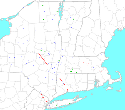
List of official tornadoes
| July 10 tornadoes | ||||||
|---|---|---|---|---|---|---|
| F# Fujita scale The Fujita scale , or Fujita-Pearson scale, is a scale for rating tornado intensity, based primarily on the damage tornadoes inflict on human-built structures and vegetation... |
Location | County | Time (UTC Coordinated Universal Time Coordinated Universal Time is the primary time standard by which the world regulates clocks and time. It is one of several closely related successors to Greenwich Mean Time. Computer servers, online services and other entities that rely on having a universally accepted time use UTC for that purpose... ) |
Path length | Damage | |
| New York New York New York is a state in the Northeastern region of the United States. It is the nation's third most populous state. New York is bordered by New Jersey and Pennsylvania to the south, and by Connecticut, Massachusetts and Vermont to the east... |
||||||
| F1 | NE of Ogdensburg Ogdensburg, New York Ogdensburg is a city in St. Lawrence County, New York, United States. The population was 11,128 at the 2010 census. In the late 18th century, European-American settlers named the community after American land owner and developer Samuel Ogden.... |
St. Lawrence County | 1019 | 1.7 miles (2.7 km) | Ninety feet across. One injury was reported due to the tornado, with another attributed to winds due to the parent thunderstorm. | |
| F4 | Ames Ames, New York Ames is a village in Montgomery County, New York, United States. The population was 173 at the 2000 census.The Village of Ames is in the south-central part of the Town of Canajoharie and is south of the Village of Canajoharie.... to near East Durham Durham, New York Durham is a town in Greene County, New York, United States. The population was 2,725 at the 2010 census. The town was named after Durham, Connecticut.The Town of Durham is in the northwest corner of the county.- History :... |
Montgomery Montgomery County, New York As of the census of 2000, there were 49,708 people, 20,038 households, and 13,104 families residing in the county. The population density was 123 people per square mile . There were 22,522 housing units at an average density of 56 per square mile... to Greene Greene County, New York Greene County is a county located in the U.S. state of New York. Its name is in honor of the American Revolutionary War general Nathanael Greene. Its county seat is Catskill... , main impact felt in Schoharie Schoharie County, New York As of the census of 2000, there were 31,582 people, 11,991 households and 8,177 families residing in the county. The population density was 51 people per square mile . There were 15,915 housing units at an average density of 26 per square mile... |
1827 | 42 miles (67.6 km) | See main section on this tornado. | |
| F2 | Near Carmel Hamlet Carmel Hamlet, New York Carmel Hamlet is the seat of Putnam County, New York, United States. It is a hamlet located in the Town of Carmel. As of the 2000 census, the population was 5,650.... |
Putnam Putnam County, New York Putnam County is a county located in the U.S. state of New York, in the lower Hudson River Valley. Putnam county formed in 1812, when it detached from Dutchess County. , the population was 99,710. It is part of the New York Metropolitan Area. The county seat is the hamlet of Carmel... |
2158 | 0.5 mile (0.80467 km) | Five injuries reported. | |
| F2 | Moriches Moriches, New York Moriches is a hamlet in Suffolk County, New York, United States. The population was 2,319 at the 2000 census.Moriches is served by the William Floyd School District.... |
Suffolk Suffolk County, New York Suffolk County is a county located in the U.S. state of New York on the eastern portion of Long Island. As of the 2010 census, the population was 1,493,350. It was named for the county of Suffolk in England, from which its earliest settlers came... |
2315 | 0.2 mile (0.321868 km) | One injury reported. See main section on this tornado. | |
| Massachusetts Massachusetts The Commonwealth of Massachusetts is a state in the New England region of the northeastern United States of America. It is bordered by Rhode Island and Connecticut to the south, New York to the west, and Vermont and New Hampshire to the north; at its east lies the Atlantic Ocean. As of the 2010... |
||||||
| F1 | Hubbardston Hubbardston, Massachusetts Hubbardston is a town in Worcester County, Massachusetts, United States. As of the 2010 U.S. census, the town population was 4,382.- History :... |
Worcester Worcester County, Massachusetts -Demographics:In 1990 Worcester County had a population of 709,705.As of the census of 2000, there were 750,963 people, 283,927 households, and 192,502 families residing in the county. The population density was 496 people per square mile . There were 298,159 housing units at an average density... |
2004 | 0.3 mile (0.482802 km) | See main section on the Massachusetts tornadoes. | |
| F1 | Princeton Princeton, Massachusetts Princeton is a town in Worcester County, Massachusetts, United States.It is bordered on the east by Sterling and Leominster, on the north by Westminster, on the northwest by Hubbardston, on the southwest by Rutland, and on the southeast by Holden.... |
Worcester | 2010 | 0.3 mile (0.482802 km) | ||
| F1 | Sterling Sterling, Massachusetts Sterling is a town in Worcester County, Massachusetts, USA. The population was 7,808 at the 2010 census.- History :Sterling was first settled by Europeans in 1720 and was officially incorporated in 1781.... |
Worcester | 2010 | 0.3 mile (0.482802 km) | ||
| F1 | W of Boylston Boylston, Massachusetts Boylston is a town in Worcester County, Massachusetts, United States. The population was 4,355 at the 2010 census.-History:Boylston was first settled by Europeans around 1706 in the north part of the present-day town, most notably by the Sawyer family... |
Worcester | 2015 | 0.4 mile (0.643736 km) | ||
| F0 | Canton Canton, Massachusetts Canton is a town in Norfolk County, Massachusetts, United States. The population was 21,561 at the 2010 census. Canton is part of Greater Boston, about 15 miles southwest of downtown Boston.- History :... |
Norfolk Norfolk County, Massachusetts -National protected areas:* Adams National Historical Park* Boston Harbor Islands National Recreation Area * Frederick Law Olmsted National Historic Site* John Fitzgerald Kennedy National Historic Site-Demographics:... |
2110 | 0.1 miles (160.9 m) | ||
| F1 | Near Brockton Brockton, Massachusetts Brockton is a city in Plymouth County, Massachusetts, United States; the population was 93,810 in the 2010 Census. Brockton, along with Plymouth, are the county seats of Plymouth County... |
Plymouth Plymouth County, Massachusetts Plymouth County is a county located in the U.S. state of Massachusetts. As of 2010, the population was 494,919. Its county seats are Plymouth and Brockton... |
2125 | 0.1 miles (160.9 m) | One injury reported. | |
| F0 | East of Hanover Hanover, Massachusetts Hanover is a town in Plymouth County, Massachusetts, United States. The population was 13,164 at the 2000 census.-History:The area of Hanover was first settled by English settlers in 1649 when William Barstow, a farmer, built a bridge along the North River at what is now Washington Street... |
Plymouth | 2130 | 0.1 miles (160.9 m) | ||
| Connecticut Connecticut Connecticut is a state in the New England region of the northeastern United States. It is bordered by Rhode Island to the east, Massachusetts to the north, and the state of New York to the west and the south .Connecticut is named for the Connecticut River, the major U.S. river that approximately... |
||||||
| F2 | Cornwall Cornwall, Connecticut Cornwall is a town in Litchfield County, Connecticut, United States. The population was 1,434 at the 2000 census.In 1939 poet Mark Van Doren wrote "The Hills of Little Cornwall", a short poem in which the beauties of the countryside were portrayed as seductive:The town was also home to the Foreign... to near Morris Morris, Connecticut Morris is a town in Litchfield County, Connecticut, United States. The population was 2,301 at the 2000 census. The town consists of rolling hill country surrounding Bantam Lake, the largest natural lake in the State, covering about .-History:... |
Litchfield Litchfield County, Connecticut Litchfield County is a county located in the northwestern corner of the U.S. state of Connecticut. Litchfield County has the lowest population density of any county in Connecticut but is geographically the state's largest county. As of 2010 the population was 189,927... |
2040 | 10 miles (16.1 km) | Four injuries reported. See main section on the Connecticut tornadoes. | |
| F2 | Watertown Watertown, Connecticut Watertown is a town in Litchfield County, Connecticut, United States. The population was 21,661 at the 2000 census. The zip code for Watertown is 06795. It is a suburb of Waterbury. It borders the towns of Woodbury, Middlebury, Litchfield, Plymouth, Bethlehem, and Thomaston.-Founding History:More... to northern Waterbury Waterbury, Connecticut Waterbury is a city in New Haven County, Connecticut, on the Naugatuck River, 33 miles southwest of Hartford and 77 miles northeast of New York City... |
Litchfield, New Haven New Haven County, Connecticut New Haven County is a county located in the south central part of the U.S. state of Connecticut. As of the 2010 Census, the county population is 862,477 making it the third most populated county in Connecticut. There are 1,340 people per square mile... |
2115 | 5 miles (8 km) | 70 injuries reported. | |
| F4 | Hamden Hamden, Connecticut Hamden is a town in New Haven County, Connecticut, United States. The town's nickname is "The Land of the Sleeping Giant." Hamden is home to Quinnipiac University. The population was 58,180 according to the Census Bureau's 2005 estimates... |
New Haven | 2145 | 3 miles (4.8 km) | Highwood section of Hamden devastated. Forty people injured. | |
| New Jersey New Jersey New Jersey is a state in the Northeastern and Middle Atlantic regions of the United States. , its population was 8,791,894. It is bordered on the north and east by the state of New York, on the southeast and south by the Atlantic Ocean, on the west by Pennsylvania and on the southwest by Delaware... |
||||||
| F1 | West Milford West Milford, New Jersey West Milford is a township in Passaic County, New Jersey, United States. As of the 2010 United States Census, the township population was 25,850.-History:... to Ringwood Ringwood, New Jersey -Demographics:As of the census of 2000, there are 12,396 people, 4,108 households, and 3,446 families residing in the borough. The population density is 491.0 people per square mile . There are 4,221 housing units at an average density of 167.2 per square mile... |
Passaic Passaic County, New Jersey Passaic County is a county located in the U.S. state of New Jersey. As of the 2010 Census, the population was 501,226. Its county seat is Paterson... |
2300 | 4.5 miles (7.2 km) | See main section on the New Jersey tornadoes. | |
| F0 | Oakland Oakland, New Jersey Oakland is a borough in Bergen County, New Jersey, United States. As of the 2010 United States Census, the borough population was 12,754.Oakland was incorporated as a borough by an Act of the New Jersey Legislature on April 8, 1902, from portions of Franklin Township.-History:The Van Allen House... to Franklin Lakes Franklin Lakes, New Jersey Franklin Lakes is a borough in Bergen County, New Jersey, United States. As of the 2010 census, the borough population was 10,590. As of the 2000 Census, Franklin Lakes had the 18th-highest per-capita income of all 566 municipalities in the state. Nationwide, Franklin Lakes ranked 17th among the... |
Bergen Bergen County, New Jersey Bergen County is the most populous county of the state of New Jersey, United States. As of the 2010 United States Census, its population was 905,116. The county is part of the New York City Metropolitan Area. Its county seat is Hackensack... |
2319 | 3.5 miles (5.6 km) | ||
| F0 | Garfield Garfield, New Jersey Garfield is a city in Bergen County, New Jersey, United States. As of the 2010 United States Census, the city population was 30,487.When the area that is now Garfield was first developed in 1873, it was known as East Passaic. In 1881, the community's name was changed to Garfield in honor of... to Fort Lee Fort Lee, New Jersey Fort Lee is a borough in Bergen County, New Jersey, United States. As of the 2010 United States Census, the borough population was 35,345. Located atop the Hudson Palisades, the borough is the western terminus of the George Washington Bridge... |
Bergen | 2346 | 4 miles (6.4 km) | ||
| Sources: NCDC National Climatic Data Center The United States National Climatic Data Center in Asheville, North Carolina is the world's largest active archive of weather data. The center became established in late 1951, with the move into the new facility occurring in early 1952.... Storm Events Database "Significant Tornadoes 1680-1991" SPC Storm Prediction Center The Storm Prediction Center , located in Norman, Oklahoma, is tasked with forecasting the risk of severe thunderstorms and tornadoes in the contiguous United States. The agency issues convective outlooks, mesoscale discussions, and watches as a part of this process... Storm Data |
||||||
Storm details
Ogdensburg, New York
Ogdensburg is a city in St. Lawrence County, New York, United States. The population was 11,128 at the 2010 census. In the late 18th century, European-American settlers named the community after American land owner and developer Samuel Ogden....
at 5AM, injuring one person. Hail up to 1 in (25 mm) wide, wind gusts over 50 mph (60 km/h), and many reports of wind damage were reported in New York, Vermont
Vermont
Vermont is a state in the New England region of the northeastern United States of America. The state ranks 43rd in land area, , and 45th in total area. Its population according to the 2010 census, 630,337, is the second smallest in the country, larger only than Wyoming. It is the only New England...
, and Massachusetts before noon. Severe weather
Severe weather
Severe weather phenomena are weather conditions that are hazardous to human life and property.- Examples Include :Severe weather can occur under a variety of situations, but three characteristics are generally needed: a temperature or moisture boundary, moisture, and , instability in the...
is an unusual occurrence in the morning, and the activity only increased in severity towards the middle of the afternoon.
Schoharie County tornado
The event which devastated areas from Montgomery to Greene County caused $20,000,000 in damage and injured 20 people. While the Storm Prediction CenterStorm Prediction Center
The Storm Prediction Center , located in Norman, Oklahoma, is tasked with forecasting the risk of severe thunderstorms and tornadoes in the contiguous United States. The agency issues convective outlooks, mesoscale discussions, and watches as a part of this process...
archives say that it was a single tornado, it was likely three or more tornadoes, each producing F3 to F4 damage. Only damage near Greenville was at the F4 level, and some sources doubt it even reached that intensity at all.
The first tornado touched down three miles east of Ames
Ames, New York
Ames is a village in Montgomery County, New York, United States. The population was 173 at the 2000 census.The Village of Ames is in the south-central part of the Town of Canajoharie and is south of the Village of Canajoharie....
at 1:27PM, moving southeast. It passed near or through the towns of Carlisle
Carlisle, New York
Carlisle is a town in northern Schoharie County, New York, United States. The population was 1,758 at the 2000 census.- History :The town was first settled around 1760.The town of Carlisle was established in 1807 from the towns of Cobleskill and Sharon...
, Howe Caverns
Howe Caverns
Howe Caverns is a cave in Howes Cave, Schoharie County, New York.-Geology:Geologists believe that the formation of the cave, which lies below ground, began several million years ago...
, Central Bridge, and Schoharie
Schoharie (town), New York
Schoharie is a town in Schoharie County, New York. The population was 3,299 at the 2000 census. The village is named after a native word for driftwood.The Town of Schoharie has a village, also called Schoharie...
before lifting. Continuing southeast for 10 miles, the storm produced another tornado briefly near Rensselaerville
Rensselaerville, New York
Rensselaerville is a town in Albany County, New York, United States. The population was 1,843 at the 2010 census. The town is named after Stephen Van Rensselaer...
. After another 10 miles, a third tornado touched down between Greenville
Greenville (town), New York
Greenville is a town on the northern border of Greene County, New York, United States. The population was 3,739 at the 2010 census.- History :...
and Surprise. This final section of the path is plotted as a skipping tornado
Skipping tornado
A skipping tornado is a vaguely defined term which refers to a tornado which has a discontinuous damage path. This may be due to several factors:#The tornado actually lifting from the surface...
, but may have been three or more separate tornadoes.
Connecticut tornado family
An hour after the previous event caused destruction in Upstate New York, a new tornado family began producing significant damage in the adjacent state of ConnecticutConnecticut
Connecticut is a state in the New England region of the northeastern United States. It is bordered by Rhode Island to the east, Massachusetts to the north, and the state of New York to the west and the south .Connecticut is named for the Connecticut River, the major U.S. river that approximately...
. The first tornado, which may have been three separate tornadoes, started its path of destruction in Cornwall
Cornwall, Connecticut
Cornwall is a town in Litchfield County, Connecticut, United States. The population was 1,434 at the 2000 census.In 1939 poet Mark Van Doren wrote "The Hills of Little Cornwall", a short poem in which the beauties of the countryside were portrayed as seductive:The town was also home to the Foreign...
, leveling a virgin forest
Virgin Forest
Virgin Forest is a self-described B-movie starring Sarsi Emmanuel, who plays a barrio lass of Chinese ancestry; the late Miguel Rodriguez, as a Filipino-Spanish illustrado; and, Abel Jurado, who plays the lover of Sarsi's character.-Synopsis:...
known as Cathedral Pines
Cathedral Pines
Cathedral Pines is a nature preserve owned and managed by The Nature Conservancy in Cornwall, Connecticut. It is an old-growth white pine and hemlock forest which had been donated in 1967 by the Calhoun family who had purchased it in 1883 to prevent logging...
. At the nearby Mohawk Mountain Ski Area
Mohawk Mountain Ski Area
Mohawk Mountain is a small ski area located in Cornwall, Connecticut. The ski area was built on the northeast slope of Mohawk Mountain by Walt Schoenknecht in 1947. It is a popular destination for both day and night skiers and snowboarders in the Connecticut area...
, every ski lift
Ski lift
The term ski lift generally refers to any transport device that carries skiers up a hill. A ski lift may fall into one of the following three main classes:-Lift systems and networks:...
was destroyed, with some lift chairs found miles away. The tornado continued south-southeast
Cardinal direction
The four cardinal directions or cardinal points are the directions of north, east, south, and west, commonly denoted by their initials: N, E, S, W. East and west are at right angles to north and south, with east being in the direction of rotation and west being directly opposite. Intermediate...
through Milton, leveling hundreds more trees, and destroyed the village of Bantam
Bantam, Connecticut
Bantam is a borough in Litchfield County, Connecticut, United States. The population was 759 at the 2000 census.While separated for census and historic reasons, Bantam is governed as an integral part of the town of Litchfield...
before dissipating. Strong downburst
Downburst
A downburst is created by an area of significantly rain-cooled air that, after reaching ground level, spreads out in all directions producing strong winds. Unlike winds in a tornado, winds in a downburst are directed outwards from the point where it hits land or water...
winds continued to cause damage and level trees after this tornado lifted: it was during this period between tornadoes that a 12-year-old girl was killed by falling trees in Black Rock State Park
Black Rock State Park
Black Rock State Park is a state park in Watertown, Connecticut. The park is opened during the spring, fall, and summer seasons. The park offers swimming, camping, and hiking trails...
.
Soon afterwards, another tornado touched down in Watertown
Watertown, Connecticut
Watertown is a town in Litchfield County, Connecticut, United States. The population was 21,661 at the 2000 census. The zip code for Watertown is 06795. It is a suburb of Waterbury. It borders the towns of Woodbury, Middlebury, Litchfield, Plymouth, Bethlehem, and Thomaston.-Founding History:More...
, passing through Oakville
Oakville, Connecticut
Oakville is a census-designated place and neighborhood section of Watertown, Connecticut. in Litchfield County, Connecticut, United States. The population was 8,618 at the 2000 census. The zip code for Oakville, Connecticut is 06779.-Geography:...
and northern Waterbury
Waterbury, Connecticut
Waterbury is a city in New Haven County, Connecticut, on the Naugatuck River, 33 miles southwest of Hartford and 77 miles northeast of New York City...
, damaging or destroying 150 homes.
The Hamden tornado was by far the most destructive tornado of this family, and possibly the most damaging of the entire outbreak. It touched down at 5:38 pm near the Wilbur Cross Parkway
Wilbur Cross Parkway
The Wilbur Cross Parkway is a limited access road in Connecticut, comprising the portion of Route 15 between Milford and Meriden. It is named after Wilbur Lucius Cross, a former governor of the state...
. Industrial cranes and cars were tossed through the air, and rows of houses, as well as an industrial park, were flattened. The tornado lifted just a few minutes later at 5:45. The damage path was only five miles long, stopping just short of the city of New Haven, but it damaged or destroyed almost 400 structures in its path.
The storm was so intense at this point that an 80 mph (130 km/h) wind gust was measured in downtown New Haven after the tornado dissipated. About the same time, a tornado struck the area between Carmel and Brewster, New York
Brewster, New York
Brewster is a village within the town of Southeast in Putnam County, New York, United States. Its population was 2,162 at the 2000 census. The village is the most densely populated portion of the town...
, unroofing a condominium
Condominium
A condominium, or condo, is the form of housing tenure and other real property where a specified part of a piece of real estate is individually owned while use of and access to common facilities in the piece such as hallways, heating system, elevators, exterior areas is executed under legal rights...
complex. Five people were injured.
Long Island
The storms continued to produce damage after crossing onto Long IslandLong Island
Long Island is an island located in the southeast part of the U.S. state of New York, just east of Manhattan. Stretching northeast into the Atlantic Ocean, Long Island contains four counties, two of which are boroughs of New York City , and two of which are mainly suburban...
. An F2 tornado caused significant damage in the town of East Moriches
Moriches, New York
Moriches is a hamlet in Suffolk County, New York, United States. The population was 2,319 at the 2000 census.Moriches is served by the William Floyd School District....
. A man was thrown with his trailer across an airfield; he escaped the destroyed trailer with only minor injuries. The tornado was accompanied by 2.5 inch (6.4 cm) hail. Other areas further east also saw straight-line wind damage and hail up to an inch across.
Massachusetts storms
While the destructive tornadoes were affecting Connecticut, this part of the storm produced four brief F1 tornadoes in quick succession north of WorcesterWorcester, Massachusetts
Worcester is a city and the county seat of Worcester County, Massachusetts, United States. Named after Worcester, England, as of the 2010 Census the city's population is 181,045, making it the second largest city in New England after Boston....
, which occurred between 4PM and 4:15PM. These tornadoes each produced damage paths less than 150 feet (45 m) wide, and less than 0.5 miles (0.8 km) long.
Moving east-southeast
Cardinal direction
The four cardinal directions or cardinal points are the directions of north, east, south, and west, commonly denoted by their initials: N, E, S, W. East and west are at right angles to north and south, with east being in the direction of rotation and west being directly opposite. Intermediate...
into southern Middlesex County
Middlesex County, Massachusetts
-National protected areas:* Assabet River National Wildlife Refuge* Great Meadows National Wildlife Refuge* Longfellow National Historic Site* Lowell National Historical Park* Minute Man National Historical Park* Oxbow National Wildlife Refuge...
, it continued producing severe winds (gusting up to 90 mph; 145 km/h) and very heavy rain. Another tornado touched down very briefly in Norfolk County, followed by two more brief touchdowns in Plymouth County near 5:30PM. The storm then weakened, but still managed to produce 60 mph (95 km/h) winds on Cape Cod
Cape Cod
Cape Cod, often referred to locally as simply the Cape, is a cape in the easternmost portion of the state of Massachusetts, in the Northeastern United States...
, before finally moving out into the Atlantic
Atlantic Ocean
The Atlantic Ocean is the second-largest of the world's oceanic divisions. With a total area of about , it covers approximately 20% of the Earth's surface and about 26% of its water surface area...
and dissipating.
New Jersey storms
Around the same time, the last of the activity was affecting areas of northern New Jersey. Two F0s and an F1 tracked through parts of Passaic and Bergen counties, snapping and uprooting trees, and causing $4 million in damage. About 150 houses were damaged in Bergen county alone.Aftermath
In Waterbury, ConnecticutWaterbury, Connecticut
Waterbury is a city in New Haven County, Connecticut, on the Naugatuck River, 33 miles southwest of Hartford and 77 miles northeast of New York City...
, mayor Joseph Santopietro declared a state of emergency due to extensive damage in the city.
In Hamden, Connecticut
Hamden, Connecticut
Hamden is a town in New Haven County, Connecticut, United States. The town's nickname is "The Land of the Sleeping Giant." Hamden is home to Quinnipiac University. The population was 58,180 according to the Census Bureau's 2005 estimates...
, the National Guard was called in to aid in cleanup and keep order, as some looting was reported in the devastated area. President George H. W. Bush
George H. W. Bush
George Herbert Walker Bush is an American politician who served as the 41st President of the United States . He had previously served as the 43rd Vice President of the United States , a congressman, an ambassador, and Director of Central Intelligence.Bush was born in Milton, Massachusetts, to...
declared the area a disaster area on July 18. The damage was so intense that much of the area was without power for a week, and trees were still being cleared a year later.
There was some damage to homes and other structures from this storm, however, most damage was confined to wooded areas. Several major roads, including Route 9, Route 12
Route 12 (New England)
New England Route 12 was a multi-state north–south state highway in the New England region of the United States, running from Groton, Connecticut, through Worcester, Massachusetts, and Keene, New Hampshire, to Morrisville, Vermont. Its number dates from 1922, when it was a New England...
, and Interstate 190
Interstate 190 (Massachusetts)
Interstate 190 runs for north from I-290 in Worcester, Massachusetts to Route 2 in Leominster, Massachusetts. A portion of the highway was built with extra-wide shoulders, which are painted green, to prevent runoff from contaminating the nearby Wachusett Reservoir...
, were closed due to flooding or downed trees. The main financial impact was from damage to utilities, which totalled over $2 million in Princeton
Princeton, Massachusetts
Princeton is a town in Worcester County, Massachusetts, United States.It is bordered on the east by Sterling and Leominster, on the north by Westminster, on the northwest by Hubbardston, on the southwest by Rutland, and on the southeast by Holden....
alone.
Despite the extensive and widespread damage, only one death was reported from the entire severe weather outbreak, and this was due to straight-line winds, not a tornado. Many people, including Connecticut Governor William O'Neill
William O'Neill (Connecticut politician)
William Atchison O'Neill was a twentieth century U.S. political figure, most notably as the 84th Governor of Connecticut from 1980 to 1991....
, commented that it was "a miracle" that more people were not seriously injured or killed.
Historic outbreak
This storm event was one of the most extensive ever seen in the Northeastern United StatesNortheastern United States
The Northeastern United States is a region of the United States as defined by the United States Census Bureau.-Composition:The region comprises nine states: the New England states of Connecticut, Maine, Massachusetts, New Hampshire, Rhode Island and Vermont; and the Mid-Atlantic states of New...
. In all, 17 tornadoes touched down, possibly more. There were 14 instances of measured severe winds (several over 80 mph, 129 km/h), along with 46 reports of straight-line wind
Downburst
A downburst is created by an area of significantly rain-cooled air that, after reaching ground level, spreads out in all directions producing strong winds. Unlike winds in a tornado, winds in a downburst are directed outwards from the point where it hits land or water...
damage. There were 10 reports of hail 1 inch (2.5 cm) across or larger, and hail 2.5 inches (6.4 cm) wide fell from one storm, which was producing a tornado at the time. Hail this large is especially rare in this area of the world.
Remarkably, though hundreds of homes and other structures were leveled, no one was killed by tornadoes that day. Tornado damage caused about 140 injuries, mostly minor, and one death and 11 injuries were caused by wind damage. In just five hours, the storms produced more than 12,500 lightning
Lightning
Lightning is an atmospheric electrostatic discharge accompanied by thunder, which typically occurs during thunderstorms, and sometimes during volcanic eruptions or dust storms...
strikes. The airport in Oxford, Connecticut
Oxford, Connecticut
Oxford is a town located in western New Haven County, Connecticut, United States. The population was 12,272 at the 2010 Census. There are several areas in Oxford: Quaker Farms, Riverside and Oxford Center. Oxford belongs to the Naugatuck Valley Economic Development Region and the Central...
recorded 4.4 inches (112 mm) of rain
Rain
Rain is liquid precipitation, as opposed to non-liquid kinds of precipitation such as snow, hail and sleet. Rain requires the presence of a thick layer of the atmosphere to have temperatures above the melting point of water near and above the Earth's surface...
in just 30 minutes. While the northeastern United States experiences occasional tornadoes, an event of this scale is especially rare. Typical tornadoes in this area are short-lived and not particularly damaging. This outbreak featured several long-lived tornadoes, produced by storms which also produced destructive non-tornadic winds over a large area. Since 1950, only six violent tornadoes have occurred in the Northeastern US, two of which were part of this outbreak. It was by far the worst tornado event in the area since May 2, 1983, when six significant tornadoes tore through New York
New York
New York is a state in the Northeastern region of the United States. It is the nation's third most populous state. New York is bordered by New Jersey and Pennsylvania to the south, and by Connecticut, Massachusetts and Vermont to the east...
, and maybe the worst since the Worcester Tornado.
See also
- Flint-Worcester tornado outbreak sequence
- List of Connecticut tornadoes
- Late-May 1998 Tornado Outbreak and Derecho
- List of North American tornadoes and tornado outbreaks