
Nong Khai Province
Encyclopedia
Nong Khai is the northernmost of the north-eastern
(Isan) provinces
(changwat) of Thailand
. Neighboring provinces are (from east clockwise) Bueng Kan
, Sakon Nakhon
, Udon Thani
and Loei
. To the north it borders Vientiane Province, Vientiane Prefecture and Bolikhamxai of Laos
.
river), which also forms the border with Laos. There are highlands to the south. The Laotian capital Vientiane
is only 25 kilometers away from the provincial capital of Nong Khai. The Thai-Lao Friendship Bridge, which connects the two countries, was built jointly by the governments of Thailand, Laos and Australia, and was opened in 1994.
, and the Laotian kingdom Lan Xang
, as their respective powers ebbed and flowed in the region. See also the Haw wars
.
). The districts are further subdivided into 62 subdistricts (tambon
) and 705 villages (muban
). The 8 districts of Bueng Kan
were districts of Nong Khai before, they were split as the newest province of Thailand.
Wat Pho Chai (วัดโพธิ์ชัย) Luangpho Phra Sai, a sacred Buddha image of the town which is respected by the people of Nong Khai, is housed here. Every year on the full moon day in the seventh lunar month, the people of Nong Khai always hold a rocket merit-making fair or Bun Bang Fai to worship Phra Sai at Wat Pho Chai.
Tha Sadet Market (ตลาดท่าเสด็จ) This is a source of products from Indochina and East Europe, including dried food, processed food, and utensils, such as electric appliances, clothes, watches, kitchenware, etc.
Phrathat Nong Khai or Phrathat Klang Nam (พระธาตุหนองคาย หรือ พระธาตุกลางน้ำ) is a broken pagoda in the middle of the Mekong River. According to the legend of Urangkhathat (Phrathat Phanom), nine pieces of the Lord Buddha’s foot relics were kept here. It was presumed that the pagoda was built in around the 15th – 17th Century.
Sala Kaeo Ku or Wat Khaek (ศาลาแก้วกู่ หรือ วัดแขก) This place which looks like an open museum of religious statues was created with an inspiration of Luangpu Bunluea Surirat who built it around 1978, out of his own belief that the teachings of all regions could be mixed together. Therefore, there are Buddha images in different attitudes.
Hat Chom Mani or Chom Mani Beach (หาดจอมมณี) It is a sandy beach stretching about 200 m and only emerging during the dry season.
Thai – Lao Friendship Bridge (สะพานมิตรภาพไทย-ลาว) is a link over the Mekong River between Amphoe Mueang Nong Khai of Thailand and Tha Duea of the Lao People’s Democratic Republic. It was built with cooperation from three countries: Australia, Laos, and Thailand.
Phrathat Bang Phuan (พระธาตุบังพวน) Within the temple compound, there are interesting ancient places such as Sattamahasathan or the seven important places in the history of the Lord Buddha after his enlightenment, and Sa Pappharanak or Sa Phaya Nak (pond of the Naga serpent) where in the past the water was taken to bathe a newly appointed ruler of the town as an auspicious gesture.
Luangpho Phrachao Ong Tue (หลวงพ่อพระเจ้าองค์ตื้อ) This is a large, cast bronze, Buddha image. It is housed in Wat Si Chomphu Ong Tue, Ban Nam Mong. The royal artisans of the northern city and Lan Chang constructed the image over seven years and seven months.
Tobacco-making Village (หมู่บ้านทำยาสูบ) The villagers grow tobacco plantations along the area parallel to the Mekong River.
Freshwater Fishery Village (หมู้บ้านประมงน้ำจืด) The villagers here have freshwater fishery as a profession. Freshwater species of fish raised in their farms are Pla Taphian, Pla Nai, Pla Nuan Chan, Pla Yisok Thet, Pla Klet Ngoen, Pla Hua To, Pla Duk Thet, etc.
Krayo Pastry-making Village (หมู่บ้านทำแผ่นกระยอ) Here, bamboo trays are seen with Krayo pastry being sun-dried along the roadsides. Krayo pastry is used for Vietnamese food such as Popia (spring rolls) and Naem Nueang (wrap of pork and vegetables with spicy sauce).
Phra Sutham Chedi, Wat Aranyabanphot (พระสุธรรมเจดีย์ วัดอรัญญบรรพต) Relics of the Lord Buddha are enshrined in this Chedi which also serves as a museum. The Chedi was constructed by the Electricity Generating Authority of Thailand as a tribute to Luangpu Rian Woralapho.
Wat Hin Mak Peng (วัดหินหมากเป้ง) The temple compound is spacious, clean and shady with various species of plants amidst tranquility. Inside the temple, there is a statue of Luangpu Thet on display with the eight requisites and his biography.
Namtok Than Thong (น้ำตกธารทอง) This waterfall has its stream flowing along the rocky ground. Tiers of small cascades line below for a distance of around 30 m before merging with the Mekong River.
Namtok Than Thip (น้ำตกธารทิพย์) is a high and beautiful waterfall amidst a lush forest. It has three tiers.
Nong Khai Horticultural Research Centre (ศูนย์วิจัยพืชสวนหนองคาย) There are furrows of local vegetables, such as Krachiao, Phakkat Ya, Som Mong, Phak Wan Pa, etc. Besides, local herbs and more than 100 species of fragrant flowers are gathered here. During the cool season, colourful temperate flowers will be grown as well.
Wat Sawang Arom or Wat Tham Si Thon (วัดสว่างอารมณ์ หรือ วัดถ้ำศรีธน) It is shady with trees and a small stream flows through it. The Ubosot (ordination hall) stands on a giant boulder. Down below, a reclining Buddha image is housed for the people to pay homage to.
Phu Thok (ภูทอก) means an isolated mountain in Isan dialect. It consists of two hills: Phu Thok Yai and Phu Thok Noi. Previously, this area was dense woods with many wild animals. Because of its tranquility, Phra Achan Chuan Kunlachettho, a meditation master, initially established a meditation place here for Buddhists to practise the Buddha’s teachings.
Phu Wua Wildlife Sanctuary (เขตรักษาพันธุ์สัตว์ป่าภูวัว) This sanctuary is around 150-300 m above sea level. Types of forest here are mostly Deciduous Dipterocarp Forest, Dry Evergreen Forest and Moist Evergreen Forest. Some parts of the area are sandstone mountain ridges, rocky grounds and grass fields.
Places of Interest:
Namtok Tham Fun (น้ำตกถ้ำฝุ่น) The waterfall is encompassed by a timber forest with a scenic view of the northern Phu Wua. There is water only in the rainy season.
Namtok Chet Si (น้ำตกเจ็ดสี) The falling water that hits the rocks below causes a spray of water which gives rainbow colours when seen in sunlight. So came the name “Namtok Chet Si,” which means a waterfall of seven colours.
Namtok Phu Tham Phra (น้ำตกภูถ้ำพระ) Like other waterfalls at Phu Wua, it has water only in the rainy season.
Namtok Chanaen (น้ำตกชะแนน) It is 100 m wide and has two tiers with an interval of 300 m. The path to the waterfall passes Khua Hin or a natural stone bridge of around 100 m long, where a phenomenon of water disappearing under the bridge can be witnessed.
Trut Songkran Fair (งานตรุษสงกรานต์) Being held at Wat Pho Chai on Songkran Day every year. Luangpho Phra Sai and important Buddha images from other temples will be put on a procession to go around town for the general public to pay homage to and bathe the holy images.
Bun Bang Fai Fair (งานบุญบั้งไฟ) Being held in the sixth lunar month (May) every year. There is a rocket contest to worship Phaya Thaen, the god of rain; this is the way that the local people ask for rain. A temple fair will be organised in the grounds of Wat Pho Chai. Rocket shooting will be done on the field around 10 km. from Wat Pho Chai.
Bang Fai Phaya Nak (บั้งไฟพญานาค) This extraordinary miracle always occurs at the beginning of the full moon night in the eleventh lunar month (End of Buddhist Lent). It can be seen along the Mekong River in the districts of Mueang, Phon Phisai, Pak Khat, Bung Kan, Tha Bo, Si Chiang Mai and Sangkhom. Bang Fai Phaya Nak is a term used for red and pinkish fire balls, which according to belief, belong to Phaya Nak or the great serpent of the underwater world. On the day marking the End of Buddhist Lent, a great number of people come to witness this phenomenon.
Tak Bat Thewo and Thai - Lao Friendship Boat Race (งานตักบาตรเทโวและแข่งเรือมิตรภาพไทย-ลาว) Being held during the end of the Buddhist Lent festival every year. People come to offer alms to Buddhist monks in the morning. Long boat competitions, which the Thai and Lao sides will take turn to host, will be held on the Mekong River during the day.
Isan
Isan is the northeastern region of Thailand. It is located on the Khorat Plateau, bordered by the Mekong River to the north and east, by Cambodia to the southeast and the Prachinburi mountains south of Nakhon Ratchasima...
(Isan) provinces
Provinces of Thailand
Thailand is divided into 76 provinces , which are geographically grouped into 6 regions. The capital Bangkok is not a province but a special administrative area and is included as the 77th province since it is administered at the same level as the other 76 provinces. The name of the provinces are...
(changwat) of Thailand
Thailand
Thailand , officially the Kingdom of Thailand , formerly known as Siam , is a country located at the centre of the Indochina peninsula and Southeast Asia. It is bordered to the north by Burma and Laos, to the east by Laos and Cambodia, to the south by the Gulf of Thailand and Malaysia, and to the...
. Neighboring provinces are (from east clockwise) Bueng Kan
Bueng Kan Province
Bueng Kan is the 76th province of Thailand, established by the Act Establishing Changwat Bueng Kan, BE 2554 which entered into force on and from March 23, 2011. The province, consisting of the districts partitioned off Nong Khai Province, is situated in the northeastern region of the country,...
, Sakon Nakhon
Sakon Nakhon Province
Sakon Nakhon is one of the north-eastern provinces of Thailand. Neighboring provinces are Nong Khai, Nakhon Phanom, Mukdahan, Kalasin and Udon Thani...
, Udon Thani
Udon Thani Province
Udon Thani is one of the north-eastern provinces of Thailand. Neighboring provinces are Nong Khai, Sakon Nakhon, Kalasin, Khon Kaen, Nong Bua Lamphu and Loei.- Geography :...
and Loei
Loei Province
Loei is one of the most sparsely populated provinces of Thailand, located in the North-East. Neighboring provinces are Nong Khai, Udon Thani, Nongbua Lamphu, Khon Kaen, Phetchabun, Phitsanulok...
. To the north it borders Vientiane Province, Vientiane Prefecture and Bolikhamxai of Laos
Laos
Laos Lao: ສາທາລະນະລັດ ປະຊາທິປະໄຕ ປະຊາຊົນລາວ Sathalanalat Paxathipatai Paxaxon Lao, officially the Lao People's Democratic Republic, is a landlocked country in Southeast Asia, bordered by Burma and China to the northwest, Vietnam to the east, Cambodia to the south and Thailand to the west...
.
Geography
The province is located in the valley of the Mae Nam Kong (MekongMekong
The Mekong is a river that runs through China, Burma, Laos, Thailand, Cambodia and Vietnam. It is the world's 10th-longest river and the 7th-longest in Asia. Its estimated length is , and it drains an area of , discharging of water annually....
river), which also forms the border with Laos. There are highlands to the south. The Laotian capital Vientiane
Vientiane
-Geography:Vientiane is situated on a bend of the Mekong river, which forms the border with Thailand at this point.-Climate:Vientiane features a tropical wet and dry climate with a distinct monsoon season and a dry season. Vientiane’s dry season spans from November through March. April marks the...
is only 25 kilometers away from the provincial capital of Nong Khai. The Thai-Lao Friendship Bridge, which connects the two countries, was built jointly by the governments of Thailand, Laos and Australia, and was opened in 1994.
History
Over the centuries the control of the province swung between the Thai Kingdom AyutthayaAyutthaya kingdom
Ayutthaya was a Siamese kingdom that existed from 1350 to 1767. Ayutthaya was friendly towards foreign traders, including the Chinese, Vietnamese , Indians, Japanese and Persians, and later the Portuguese, Spanish, Dutch and French, permitting them to set up villages outside the walls of the...
, and the Laotian kingdom Lan Xang
Lan Xang
The Lao kingdom of Lan Xang Hom Kao was established in 1354 by Fa Ngum.Exiled as an infant to Cambodia, Prince Fa Ngum of Xieng Dong Xieng Thong married a daughter of the Khmer king. In 1349 he set out from Angkor at the head of a 10,000-man army to establish his own country...
, as their respective powers ebbed and flowed in the region. See also the Haw wars
Haw wars
The Haw Wars , so called in Thai, were fought against Chinese quasi-military forces invading parts of Tonkin and Thailand between the years 1865 and 1890.-Invasion of the flags:...
.
Symbols
| The provincial seal Seals of The Provinces of Thailand -Present-day provinces of Thailand:This list includes all the seals of the Provinces of Thailand. It also includes the special administrative area of the capital, Bangkok.-Former Provinces:-External links:*... shows a pond with a bamboo Bamboo Bamboo is a group of perennial evergreens in the true grass family Poaceae, subfamily Bambusoideae, tribe Bambuseae. Giant bamboos are the largest members of the grass family.... clump close to it. The bamboo symbolizes stability, glory and continuity for the peaceful and fertile land. The provincial tree is the tamalan or Burma pallisander (Dalbergia oliveri Dalbergia oliveri Dalbergia oliveri is a species of legume in the Fabaceae family which grows in tree form to 15 - 30 meters in height. The fruit is a green pod containing one to two seed which turns brown to black when ripe. It is found in Myanmar, Thailand, Laos, Cambodia, and Vietnam... ). |
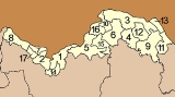
Administrative divisions
As of March 23, 2011, the province is subdivided into 9 districts (amphoeAmphoe
An amphoe is the second level administrative subdivision of Thailand. Usually translated as district, amphoe make up the provinces, and are analogous to a county seat...
). The districts are further subdivided into 62 subdistricts (tambon
Tambon
Tambon is a local government unit in Thailand. Below district and province , they form the third administrative subdivision level. As of the 2009 there are 7255 tambon, not including the 169 khwaeng of Bangkok, which are set at the same administrative level, thus every district contains 8-10 tambon...
) and 705 villages (muban
Muban
Muban is the lowest administrative subdivision of Thailand. Usually translated as village, they are the subdivision of tambon. As of 2008, there are 74944 administrative villages in Thailand. As of the 1990 census, the average village consisted of 144 households or 746 persons.A muban does not...
). The 8 districts of Bueng Kan
Bueng Kan Province
Bueng Kan is the 76th province of Thailand, established by the Act Establishing Changwat Bueng Kan, BE 2554 which entered into force on and from March 23, 2011. The province, consisting of the districts partitioned off Nong Khai Province, is situated in the northeastern region of the country,...
were districts of Nong Khai before, they were split as the newest province of Thailand.
|
Climate
Sights
Prap Ho Monument (อนุสาวรีย์ปราบฮ่อ) The cremated bones of those who lost their lives in the suppression of the Ho in 1886 have been contained inside the monument to honour the good deeds of those who sacrificed their own lives for the nation. There are inscriptions in Chinese, English, Laotian and Thai on all four directions of the monument.Wat Pho Chai (วัดโพธิ์ชัย) Luangpho Phra Sai, a sacred Buddha image of the town which is respected by the people of Nong Khai, is housed here. Every year on the full moon day in the seventh lunar month, the people of Nong Khai always hold a rocket merit-making fair or Bun Bang Fai to worship Phra Sai at Wat Pho Chai.
Tha Sadet Market (ตลาดท่าเสด็จ) This is a source of products from Indochina and East Europe, including dried food, processed food, and utensils, such as electric appliances, clothes, watches, kitchenware, etc.
Phrathat Nong Khai or Phrathat Klang Nam (พระธาตุหนองคาย หรือ พระธาตุกลางน้ำ) is a broken pagoda in the middle of the Mekong River. According to the legend of Urangkhathat (Phrathat Phanom), nine pieces of the Lord Buddha’s foot relics were kept here. It was presumed that the pagoda was built in around the 15th – 17th Century.
Sala Kaeo Ku or Wat Khaek (ศาลาแก้วกู่ หรือ วัดแขก) This place which looks like an open museum of religious statues was created with an inspiration of Luangpu Bunluea Surirat who built it around 1978, out of his own belief that the teachings of all regions could be mixed together. Therefore, there are Buddha images in different attitudes.
Hat Chom Mani or Chom Mani Beach (หาดจอมมณี) It is a sandy beach stretching about 200 m and only emerging during the dry season.
Thai – Lao Friendship Bridge (สะพานมิตรภาพไทย-ลาว) is a link over the Mekong River between Amphoe Mueang Nong Khai of Thailand and Tha Duea of the Lao People’s Democratic Republic. It was built with cooperation from three countries: Australia, Laos, and Thailand.
Phrathat Bang Phuan (พระธาตุบังพวน) Within the temple compound, there are interesting ancient places such as Sattamahasathan or the seven important places in the history of the Lord Buddha after his enlightenment, and Sa Pappharanak or Sa Phaya Nak (pond of the Naga serpent) where in the past the water was taken to bathe a newly appointed ruler of the town as an auspicious gesture.
Luangpho Phrachao Ong Tue (หลวงพ่อพระเจ้าองค์ตื้อ) This is a large, cast bronze, Buddha image. It is housed in Wat Si Chomphu Ong Tue, Ban Nam Mong. The royal artisans of the northern city and Lan Chang constructed the image over seven years and seven months.
Tobacco-making Village (หมู่บ้านทำยาสูบ) The villagers grow tobacco plantations along the area parallel to the Mekong River.
Freshwater Fishery Village (หมู้บ้านประมงน้ำจืด) The villagers here have freshwater fishery as a profession. Freshwater species of fish raised in their farms are Pla Taphian, Pla Nai, Pla Nuan Chan, Pla Yisok Thet, Pla Klet Ngoen, Pla Hua To, Pla Duk Thet, etc.
Krayo Pastry-making Village (หมู่บ้านทำแผ่นกระยอ) Here, bamboo trays are seen with Krayo pastry being sun-dried along the roadsides. Krayo pastry is used for Vietnamese food such as Popia (spring rolls) and Naem Nueang (wrap of pork and vegetables with spicy sauce).
Phra Sutham Chedi, Wat Aranyabanphot (พระสุธรรมเจดีย์ วัดอรัญญบรรพต) Relics of the Lord Buddha are enshrined in this Chedi which also serves as a museum. The Chedi was constructed by the Electricity Generating Authority of Thailand as a tribute to Luangpu Rian Woralapho.
Wat Hin Mak Peng (วัดหินหมากเป้ง) The temple compound is spacious, clean and shady with various species of plants amidst tranquility. Inside the temple, there is a statue of Luangpu Thet on display with the eight requisites and his biography.
Namtok Than Thong (น้ำตกธารทอง) This waterfall has its stream flowing along the rocky ground. Tiers of small cascades line below for a distance of around 30 m before merging with the Mekong River.
Namtok Than Thip (น้ำตกธารทิพย์) is a high and beautiful waterfall amidst a lush forest. It has three tiers.
Nong Khai Horticultural Research Centre (ศูนย์วิจัยพืชสวนหนองคาย) There are furrows of local vegetables, such as Krachiao, Phakkat Ya, Som Mong, Phak Wan Pa, etc. Besides, local herbs and more than 100 species of fragrant flowers are gathered here. During the cool season, colourful temperate flowers will be grown as well.
Wat Sawang Arom or Wat Tham Si Thon (วัดสว่างอารมณ์ หรือ วัดถ้ำศรีธน) It is shady with trees and a small stream flows through it. The Ubosot (ordination hall) stands on a giant boulder. Down below, a reclining Buddha image is housed for the people to pay homage to.
Phu Thok (ภูทอก) means an isolated mountain in Isan dialect. It consists of two hills: Phu Thok Yai and Phu Thok Noi. Previously, this area was dense woods with many wild animals. Because of its tranquility, Phra Achan Chuan Kunlachettho, a meditation master, initially established a meditation place here for Buddhists to practise the Buddha’s teachings.
Phu Wua Wildlife Sanctuary (เขตรักษาพันธุ์สัตว์ป่าภูวัว) This sanctuary is around 150-300 m above sea level. Types of forest here are mostly Deciduous Dipterocarp Forest, Dry Evergreen Forest and Moist Evergreen Forest. Some parts of the area are sandstone mountain ridges, rocky grounds and grass fields.
Places of Interest:
Namtok Tham Fun (น้ำตกถ้ำฝุ่น) The waterfall is encompassed by a timber forest with a scenic view of the northern Phu Wua. There is water only in the rainy season.
Namtok Chet Si (น้ำตกเจ็ดสี) The falling water that hits the rocks below causes a spray of water which gives rainbow colours when seen in sunlight. So came the name “Namtok Chet Si,” which means a waterfall of seven colours.
Namtok Phu Tham Phra (น้ำตกภูถ้ำพระ) Like other waterfalls at Phu Wua, it has water only in the rainy season.
Namtok Chanaen (น้ำตกชะแนน) It is 100 m wide and has two tiers with an interval of 300 m. The path to the waterfall passes Khua Hin or a natural stone bridge of around 100 m long, where a phenomenon of water disappearing under the bridge can be witnessed.
Local Products
Nong Khai has many local products for souvenirs, especially local food products such as Isan-styled sausage, Mu Yo (pork bar), Naem (fermented pork), and Vietnamese food such as Naem Nueang. In addition, there are products made of hand-woven cotton, basketry and silver ornaments available for sale at shops in town. Products being promoted on the One Tambon One Product (OTOP) programme include Huat or Muai, used to cook sticky rice.Festivals
Prap Ho Monument Fair (งานอนุสาวรีย์ปราบฮ่อ) Being held at the Prap Ho Monument around the month of March every year.Trut Songkran Fair (งานตรุษสงกรานต์) Being held at Wat Pho Chai on Songkran Day every year. Luangpho Phra Sai and important Buddha images from other temples will be put on a procession to go around town for the general public to pay homage to and bathe the holy images.
Bun Bang Fai Fair (งานบุญบั้งไฟ) Being held in the sixth lunar month (May) every year. There is a rocket contest to worship Phaya Thaen, the god of rain; this is the way that the local people ask for rain. A temple fair will be organised in the grounds of Wat Pho Chai. Rocket shooting will be done on the field around 10 km. from Wat Pho Chai.
Bang Fai Phaya Nak (บั้งไฟพญานาค) This extraordinary miracle always occurs at the beginning of the full moon night in the eleventh lunar month (End of Buddhist Lent). It can be seen along the Mekong River in the districts of Mueang, Phon Phisai, Pak Khat, Bung Kan, Tha Bo, Si Chiang Mai and Sangkhom. Bang Fai Phaya Nak is a term used for red and pinkish fire balls, which according to belief, belong to Phaya Nak or the great serpent of the underwater world. On the day marking the End of Buddhist Lent, a great number of people come to witness this phenomenon.
Tak Bat Thewo and Thai - Lao Friendship Boat Race (งานตักบาตรเทโวและแข่งเรือมิตรภาพไทย-ลาว) Being held during the end of the Buddhist Lent festival every year. People come to offer alms to Buddhist monks in the morning. Long boat competitions, which the Thai and Lao sides will take turn to host, will be held on the Mekong River during the day.