

Loei Province
Encyclopedia
Loei is one of the most sparsely populated provinces
(changwat) of Thailand
, located in the North-East
. Neighboring provinces are (from east clockwise) Nong Khai
, Udon Thani
, Nongbua Lamphu
, Khon Kaen
, Phetchabun
, Phitsanulok
. In the north it borders Xaignabouli and Vientiane Province of Laos
.
The city of Loei is surrounded by mountain ranges whose summits are covered by fog and are abundant with various kinds of flora. The best known mountains are Phu Kradueng, Phu Luang and Phu Ruea.
, which flows through the province, is a tributary of the Mekong
, which forms the northern boundary of the province with neighboring Laos.
Although temperatures in the hot season (April-May) can be more than 40 degrees Celsius, the province is the only one in Thailand which regularly drops below 0 degrees in the eveings in the cold season (December-January).
The mountain of Phu Kradueng is part of the Phu Kradueng National Park. Other national parks include Phu Hin Rong Kla
, Phu Rua, Phu Pha Man and Phu Suan Sai (also known as Na Haeo).
Phu Luang Wildlife Sanctuary
is located in the province.
(Rama IV) founded the city of Loei to administer the increasing population in the then remote area. In 1907 the province itself was created by King Chulalongkorn
(Rama V).
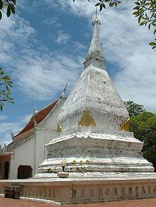
shows the stupa
at Phra That Si Song Rak
, which was built in 1560 by King Maha Chakrapat of the Ayutthaya kingdom
and King Chai Chetha
of Lan Xang
as a symboil of friendship between the two kingdoms. The provincial tree is the Khasi Pine
(Pinus kesiya).
The provinces' slogan is: City of the Sea of Mountains, Coldest Place in Siam, with Beautiful Flowers of Three Seasons.
 The province is subdivided into 14 districts (amphoe
). The districts are further subdivided into 89 subdistricts (tambon
) and 839 villages (muban
).
Chaloem Phra Kiat Public Park, Pa Loeng Yai (สวนสาธารณะเฉลิมพระเกียรติฯ ป่าเลิงใหญ่) It is a 2-rai public park by the Loei River. There is a decorative garden with various kinds of flowers and decorative plants.
Office of the Loei Tourism Coordination Centre (อาคารที่ทำการศูนย์ประสานงานการท่องเที่ยวจังหวัดเลย) was previously the City Hall and Mueang Loei District Office. The Loei Provincial Council of Culture collected the King’s chair at this place. Nowadays, the Fine Arts Department has registered it as a national ancient monument for preservation.
Loei Cultural Centre (ศูนย์วัฒนธรรมจังหวัดเลย) It is a two-storey building, collecting and publicising various aspects of information on Loei such as religion, traditions and ways of living. The centre’s building is divided into 3 sections.
Wat Tham Pha Pu or Tham Phiang Din (วัดถ้ำผาปู่ หรือ ถ้ำเพียงดิน), houses the remains of Luangpu Khamdi Paphaso, who discovered this place. The temple is a grand cave within a stone mountain. There are Buddha images enshrined in the cave, as well as, stalagmites and stalactites.
Phu Pha Lom Forest Park (วนอุทยานภูผาล้อม) It is composed of steep limestone mountains with various pointed summits similar to a wall surrounding the virgin forest in the middle. There are various kinds of plants, herbs, sightseeing points, and caves as well as, Bo Nam Sap or Nam Phut, which is a sacred seepage pond.
Upper Huai Nam Man and Huai Krathing Reservoir (อ่างเก็บน้ำห้วยน้ำหมานตอนบนและห้วยกระทิง) is an earth-filled dam with a capacity of 26 million cubic metres, covering an area of 1,500 rai with a crest of 800 metres long. It was constructed for irrigation purposes.
Wat Si Khun Mueang (วัดศรีคุณเมือง) This temple is a collection venue of Lanna and Lan Chang arts presenting at the Ubosot whose roof is in many layers reflecting the Lanna style of art. There are also many objects of art such as a carved Buddha image gilded with gold leaf on black lacquer in the forgiving posture of the Lan Chang style.
Kaeng Khutkhu (แก่งคุดคู้) is a large cataract in the middle of the Mekong River. As it is exactly situated at the curving part of the river, the flow of the swift current passes this cataract.
Phra Phutthabat Phu Khwai Ngoen (พระพุทธบาทภูควายเงิน) The Buddha’s footprint is 120 centimetres long and 65 centimetres wide, enshrined on a whetstone and was registered as a national ancient monument in 1935.
Phra Yai Phu Khok Ngio (พระใหญ่ภูคกงิ้ว) It is a walking Buddha image in the blessing posture, cast of fibre and golden resin combined. It was cast by the Second Army Area Command and the people as a form of merit making for Their Majesties the King and Queen.
Thai Dam Cultural Village (หมู่บ้านวัฒนธรรมไทยดำ) Thai Dam people migrated from Chiang Khwang Town, Lao People’s Democratic Republic, in 1905 to settle at Ban Na Pa Nat. At present, the Thai Dam culture is still preserved.
Crown Princess's Sirindhorn Art Centre (ศูนย์ศิลป์สิรินธร) It is a venue displaying beautiful paintings of students who have gained popularity at both national and international levels. Moreover, it is a source of knowledge on arts and culture, comprising both permanent and rotating exhibition halls, an arts training building.
Phu Luang Wildlife Sanctuary (เขตรักษาพันธุ์สัตว์ป่าภูหลวง) Phu Luang means a large mountain or the Mountain of the King. On the east of Phu Luang, dinosaur’s footprints on the rock, aged more than 120 million years were discovered. The most distinguished ones on Phu Luang are Pinus merkusii and Kesiya pine forests, savanna on plains, mounds, and stone terraces..
Tham Pha Ya (ถ้ำผายา) is located inside Wat Tham Pha Ya at Ban Mai Santi Tham, Tambon Na Dok Kham. Inside the cave is a flock of millions of insect-eating bats.
Ban Lek Nai Pa Yai Project, Pha Nang – Pha Koeng (โครงการบ้านเล็กในป่าใหญ่ ผานาง – ผาเกิ้ง) is a project under an initiative of Her Majesty Queen Sirikit.
Suan Hin Pha Ngam or Thailand’s Kunming
(สวนหินผางาม หรือ คุนหมิงเมืองไทย) It is a limestone garden aged around 230-280 million years, occurring from the aggradation of beach deposits. Then, an uplift of the earth’s crust, together with millions of years of natural rot have made this mountain be strangely beautiful, similar to the stone garden in Kunming
, Yunnan
of China.
Tham Mahoran (ถ้ำมโหฬาร) It is a large cave whose entrance enshrines a Buddha image in subduing Mara posture. The area within the cave is quite large consisting of stalactites and stalagmites, as well as, caves in smaller sizes. A Buddha’s footprint was also found on the wall of the cave.
Tham Phothisat (ถ้ำโพธิสัตว์) or Thailand’s Guilin is situated within the compound of Wat Tham Phothisat. It is a complex cave.
Namtok Phiang Din (น้ำตกเพียงดิน) is 4 kilometres further from Suan Hin Pha Ngam. The waterfall is at the end of the asphalt road.
Phu Kradueng National Park (อุทยานแห่งชาติภูกระดึง) It is a popular natural attraction of Thailand due to its abundance of natural resources, comprising various types of ecological systems and geography. The distinguished characteristic of this national park is that it is a sandstone mountain with a wide plain summit, whose shape is similar to a leaf of the Elephant ear or a heart. Sites in the park are as follows:
Pha Nok Aen (ผานกแอ่น) It is a small stone terrace with pine trees standing at the cliff’s edge. It is a beautiful sunrise spot overlooking the scenery of the grass field and mountain range.
Pha Lom Sak (ผาหล่มสัก) It is a wide stone terrace with a large pine tree near an overhanging cliff. It is a place where the sunset can be the most clearly viewed.
Namtok Tat Hong (น้ำตกตาดฮ้อง) is a waterfall located within the compound of the national park. When falling from the cliff to the basin, it creates a loud and resonant sound of water. Therefore, it is called “Namtok Tat Hong”.
Phu Ruea National Park (อุทยานแห่งชาติภูเรือ) Its special characteristic is an overhanging cliff in the similar shape as a prow of a junk. It is also considered as the coolest national park of the country. Sites in the national park are as follows:
Decho Viewpoint (จุดชมทิวทัศน์เดโช) is a viewspot for the sunrise. On a nice-weather-day, there are various mountains of Loei.
Pha Lon Noi (ผาโหล่นน้อย) It is a beautiful place to admire the sunrise. From this spot, Phu Luang, Phu Pha Sat, Phu Khrang and a sea of complex mountain ranges can be seen.
Pha Sapthong or Pha Kulap (ผาซับทอง หรือ ผากุหลาบ) It is a steep cliff with seepage full of water throughout the year where there is plenty of golden yellow lichen.
Namtok Huai Phai (น้ำตกห้วยไผ่) This waterfall is dropping from a steep cliff with an approximate height of 30 metres. The water from this waterfall is also utilised to produce pipe water in Amphoe Phu Ruea.
Yot Phu Ruea (ยอดภูเรือ) is the highest spot in the national park. Within its compound is a stone terrace and grass field mixed with pine forest comprising Pinus merkusii which is naturally grown and Kesiya pine which is planted.
Phrathat Si Song Rak (พระธาตุศรีสองรัก) Its architecture is in the Lan Chang style. Phrathat, a stupa containing the Buddha’s relics, is 19.19 metres high, 10.89 metres wide with a square base of 12 redented corners. Moreover, within the compound of the temple is enshrined a Buddha image canopied by a seven-headed Naga in the Tibetan style of art.
Wat Neramit Wipatsana (วัดเนรมิตวิปัสสนา) Both the Ubosot and Chedi are beautifully constructed of laterite. The large Ubosot is interiorly decorated in resemblance to the great temples of Bangkok. Moreover, a replica of Phra Phutthachinnarat is enshrined as the main image.
Phi Ta Khon Museum (พิพิธภัณฑ์บ้านผีตาโขน) It is an educational attraction for those interested in the Bun Luang and Phi Ta Khon Festivals. Besides, there are an Ubosot reflecting the skills of local craftsmen, as well as, a replica of Phrathat Si Song Rak, including Bun Luang Festival and Phi Ta Khon are organised.
Wat Pho Chai Na Phueng (วัดโพธิ์ชัยนาพึง) Enshrined within the abbot’s cell is the Prachao Ong Saen Buddha image, an ancient image of the town for many generations. At the outside of the Ubosot are paintings which were later created in 1916. It can be considered as a very precious ancient monument and object of Loei province.
Na Haeo National Park (อุทยานแห่งชาตินาแห้ว) Most of the forests are dry evergreen forests mixed with deciduous trees. Along the high area are hill evergreen forests which are also a natural boundary between Thailand and the Lao People’s Democratic Republic. Sites within the national park are as follows:
Namtok Khing (น้ำตกคิ้ง) The waterfall comprises many rock tiers. At this spot, the government has constructed a royal residence for Her Royal Highness Princess Maha Chakri Sirindhorn who visited this place on 12 February 1991.
Namtok Chang Tok (น้ำตกช้างตก) is located 500 metres higher than Namtok Khing which is also along the Phrae River. It is steeper than the lower one.
Namtok Wang Tat (น้ำตกวังตาด) is situated 1.5 kilometres above Namtok Chang Tok and located along the Phrae River as well.
Namtok Tat Hueang or Namtok Thai-Lao (น้ำตกเหืองหรือน้ำตกไทย-ลาว ) is along the Hueang River, consisting of 3 different tiers with a height of approximately 50 metres. There is water throughout the year.
Namtok Pha Khao (น้ำตกผาค้อ) is along the Heuang River, a border between Thailand and the Lao People’s Democratic Republic.
Hin Si Thit (หินสี่ทิศ) On its south are four rocks rising up in the middle of the tropical evergreen forest. Local people usually go up to pay respect at this place once every three years, thus it is called “Song Pi Ham, Sam Pi Khrop”.
Hin Kuai Lo (หินก่วยหล่อ) It is a sandstone whose shape is similar to a mushroom bud rising in the middle of the tropical evergreen forest.
Noen 1408 Viewpoint (จุดชมวิวเนิน 1408) It is the highest viewpoint and centre of the national park. It is also a beautiful viewpoint to see the sunrise.
Noen 1255 Viewpoint (จุดชมวิวเนิน 1255) is a short-distant viewpoint where the scenery of Ban Huai Nam Phak below, as well as, Phu Soi Dao and Phu Wiang in the Lao People’s Democratic Republic can be witnessed.
Phrathat Satcha (พระธาตุสัจจะ) Components of Phrathat Satcha comprise a base of blooming lotus with 3 tiers of petals with a height of approximately 1 metre around it.
The Thai-Lao Friendship Bridge across the Hueang River (สะพานมิตรภาพน้ำเหืองไทย-ลาว) It is a bridge crossing the Hueang River and connecting between Thailand and the Lao People’s Democratic Republic.
There are various kinds of local products of Loei such as sweet tamarind, Kunchiang (Chinese pork sausage), Mu Phaen (dried pork slices), glacéd coconut, Phi Ta Khon ceramic key chains, quilts, silk and cotton fabric.
Thai – Lao Songkran Festival (งานประเพณีสงกรานต์ไทย-ลาว) is organised in Amphoe Tha Li during 12–15 April of every year. It is uniquely different from other places due to the large number of Laotian people participating in the activities of the festival such as Songkran Beauty Contest and water splashing with Thai people.
Bun Bang Fai Lan Festival (งานประเพณีบุญบั้งไฟล้าน) is held within the compound of Wat Erawan Phatthanaram, Amphoe Erawan on the full moon day of the 6th lunar month or during May of every year. It is the biggest festival of Loei. There is a contest of rocket processions from various communities.
Phrathat Si Song Rak Fair (งานนมัสการพระธาตุศรีสองรัก) is an annual event organised on the full moon day of the 6th lunar month, around the end of April until early May to celebrate Phrathat Si Song Rak, a significant place of worship of the town. A holy ceremony is also conducted in the festival such as a worshipping ceremony to Phrathat by presenting Ton Phueng Yai, Ton Phueng Noi, and Phrathat bathing.
Bun Luang Festival and Phi Ta Khon (งานประเพณีบุญหลวง และการละเล่นผีตาโขน) is held annually in Amphoe Dan Sai on Saturday to Sunday after the full moon day of the 6th lunar month, and after paying respect to Phrathat Si Song Rak. Phi Ta Khon is a local activity of Amphoe Dan Sai and Amphoe Na Haeo, relating to the belief and faith in Buddhism and the spirit of ancestors. Phi Ta Khon parades are organised in the Bun Luang Festival, an annual local merit making ceremony. Phi Ta Khon is usually participated especially by males both boys and men. The festival is organised in 2 days. On the first day, the Phra Upakhut procession proceeds from the Man River to Wat Phon Chai and on the next day, it will enter the town, while the Phi Ta Khon participants will throw their costumes and accessories away into the Man River. After that, a series of all 13 chapters of the Great Birth Sermon will be given during the event.
Chiang Khan’s End of Buddhist Lent Festival (งานประเพณีออกพรรษาอำเภอเชียงคาน) is organised in front of Chiang Khan District Office on the full moon day of the 11th lunar month every year. This festival has been passed on for generations. There is the Prasat Phueng procession, long-boat races, Ruea Kap races, illuminated boat contest, Tak Bat Devo, and various local cultural shows and entertainment in the festival.
Sea of Fog and Beautiful Flower Blossom on Phu Ruea (Winter Flowers Fair, Amphoe Phu Ruea) (เทศกาลหมอก ดอกไม้งาม บานสะพรั่งภูเรือ) is held on the ground in front of Phu Ruea District Office during the New Year Festival, around 31 December – 3 January every year. Activities in the festival comprise a temperate plant fair, floral float parade, temperate flowers and decorative plants contests, Mae Khaning evening party, dances in the winter breeze.
Provinces of Thailand
Thailand is divided into 76 provinces , which are geographically grouped into 6 regions. The capital Bangkok is not a province but a special administrative area and is included as the 77th province since it is administered at the same level as the other 76 provinces. The name of the provinces are...
(changwat) of Thailand
Thailand
Thailand , officially the Kingdom of Thailand , formerly known as Siam , is a country located at the centre of the Indochina peninsula and Southeast Asia. It is bordered to the north by Burma and Laos, to the east by Laos and Cambodia, to the south by the Gulf of Thailand and Malaysia, and to the...
, located in the North-East
Isan
Isan is the northeastern region of Thailand. It is located on the Khorat Plateau, bordered by the Mekong River to the north and east, by Cambodia to the southeast and the Prachinburi mountains south of Nakhon Ratchasima...
. Neighboring provinces are (from east clockwise) Nong Khai
Nong Khai Province
Nong Khai is the northernmost of the north-eastern provinces of Thailand. Neighboring provinces are Bueng Kan, Sakon Nakhon, Udon Thani and Loei...
, Udon Thani
Udon Thani Province
Udon Thani is one of the north-eastern provinces of Thailand. Neighboring provinces are Nong Khai, Sakon Nakhon, Kalasin, Khon Kaen, Nong Bua Lamphu and Loei.- Geography :...
, Nongbua Lamphu
Nongbua Lamphu Province
Nong Bua Lam Phu is one of the north-eastern provinces of Thailand. Neighboring provinces are Udon Thani, Khon Kaen and Loei.-History:...
, Khon Kaen
Khon Kaen Province
-History:The first city of the area was established in 1783 when Rajakruluang settled there with 330 people. King Rama I made Rajakruluang the first governor of the area when establishing tighter connections with the Isan area. The main city was moved six times until in 1879 it reached its modern...
, Phetchabun
Phetchabun Province
Phetchabun is one of the northern provinces of Thailand. Neighboring provinces are Loei, Khon Kaen, Chaiyaphum, Lopburi, Nakhon Sawan, Phichit and Phitsanulok.- Geography :...
, Phitsanulok
Phitsanulok Province
Phitsanulok is a provinces of Thailand, located in the north. Neighboring provinces are Loei, Phetchabun, Phichit, Kamphaeng Phet, Sukhothai, Uttaradit. In the north-east it also has a short border with Xaignabouli of Laos....
. In the north it borders Xaignabouli and Vientiane Province of Laos
Laos
Laos Lao: ສາທາລະນະລັດ ປະຊາທິປະໄຕ ປະຊາຊົນລາວ Sathalanalat Paxathipatai Paxaxon Lao, officially the Lao People's Democratic Republic, is a landlocked country in Southeast Asia, bordered by Burma and China to the northwest, Vietnam to the east, Cambodia to the south and Thailand to the west...
.
The city of Loei is surrounded by mountain ranges whose summits are covered by fog and are abundant with various kinds of flora. The best known mountains are Phu Kradueng, Phu Luang and Phu Ruea.
Geography
The province is covered with low mountains, while the capital Loei is located in a fertile basin. The Loei RiverLoei River
The Loei River is the one of tributaries of the Mekong River. It originates at the western shore of the Phu Luang plateau, at first flowing southwards...
, which flows through the province, is a tributary of the Mekong
Mekong
The Mekong is a river that runs through China, Burma, Laos, Thailand, Cambodia and Vietnam. It is the world's 10th-longest river and the 7th-longest in Asia. Its estimated length is , and it drains an area of , discharging of water annually....
, which forms the northern boundary of the province with neighboring Laos.
Although temperatures in the hot season (April-May) can be more than 40 degrees Celsius, the province is the only one in Thailand which regularly drops below 0 degrees in the eveings in the cold season (December-January).
The mountain of Phu Kradueng is part of the Phu Kradueng National Park. Other national parks include Phu Hin Rong Kla
Phu Hin Rong Kla National Park
Phu Hin Rong Kla National Park is a national park located in the Loei, Phitsanulok and Phetchabun Provinces of Thailand.-Topography:The park landscape is generally steep mountains. The northern part of the park in stretches to the border with Laos. The Southern part of the park extends into the...
, Phu Rua, Phu Pha Man and Phu Suan Sai (also known as Na Haeo).
Phu Luang Wildlife Sanctuary
Phu Luang Wildlife Sanctuary
Phu Luang Wildlife Sanctuary is a wildlife sanctuary in northern Thailand, located in the south of Loei Province.It covers an area of 897 km², covering area of the tambon Pla Ba and Tha Sala of Phu Ruea district, Phon Sung, Wang Yao and I Pum of Dan Sai, Nong Ngio and Saikhao of Wang Saphung, and...
is located in the province.
History
In 1853 King MongkutMongkut
Phra Bat Somdet Phra Poramenthramaha Mongkut Phra Chom Klao Chao Yu Hua , or Rama IV, known in foreign countries as King Mongkut , was the fourth monarch of Siam under the House of Chakri, ruling from 1851-1868...
(Rama IV) founded the city of Loei to administer the increasing population in the then remote area. In 1907 the province itself was created by King Chulalongkorn
Chulalongkorn
Phra Bat Somdet Phra Poramintharamaha Chulalongkorn Phra Chunla Chom Klao Chao Yu Hua , or Rama V was the fifth monarch of Siam under the House of Chakri. He was known to the Siamese of his time as Phra Phuttha Chao Luang . He is considered one of the greatest kings of Siam...
(Rama V).
Symbols
The seal of the provinceSeals of The Provinces of Thailand
-Present-day provinces of Thailand:This list includes all the seals of the Provinces of Thailand. It also includes the special administrative area of the capital, Bangkok.-Former Provinces:-External links:*...
shows the stupa
Stupa
A stupa is a mound-like structure containing Buddhist relics, typically the remains of Buddha, used by Buddhists as a place of worship....
at Phra That Si Song Rak
Phra That Si Song Rak
Phra That Si Song Rak is a Buddhist stupa built in c. 1560 by Laotian and Thai kings. It is located on the Man River in Dan Sai district, Loei province of modern-day Thailand, from the modern Thailand-Laos border...
, which was built in 1560 by King Maha Chakrapat of the Ayutthaya kingdom
Ayutthaya kingdom
Ayutthaya was a Siamese kingdom that existed from 1350 to 1767. Ayutthaya was friendly towards foreign traders, including the Chinese, Vietnamese , Indians, Japanese and Persians, and later the Portuguese, Spanish, Dutch and French, permitting them to set up villages outside the walls of the...
and King Chai Chetha
Setthathirath
Setthathirath is considered one of the great leaders in Lao history. Throughout 1560s up until his death, he successfully defended his kingdom of Lan Xang against military campaigns of Burmese conqueror Bayinnaung, who had already subdued Xieng Mai in 1558 and Ayutthaya in 1564...
of Lan Xang
Lan Xang
The Lao kingdom of Lan Xang Hom Kao was established in 1354 by Fa Ngum.Exiled as an infant to Cambodia, Prince Fa Ngum of Xieng Dong Xieng Thong married a daughter of the Khmer king. In 1349 he set out from Angkor at the head of a 10,000-man army to establish his own country...
as a symboil of friendship between the two kingdoms. The provincial tree is the Khasi Pine
Khasi Pine
The Khasi Pine, Pinus kesiya, is one of the most distributed pines in Asia. Its range extends south and east from the Khasi hills in the northeast Indian state of Meghalaya from where it got its name to northern Thailand, Burma, Laos, southernmost China, Vietnam and the Philippines...
(Pinus kesiya).
The provinces' slogan is: City of the Sea of Mountains, Coldest Place in Siam, with Beautiful Flowers of Three Seasons.
Administrative divisions
Amphoe
An amphoe is the second level administrative subdivision of Thailand. Usually translated as district, amphoe make up the provinces, and are analogous to a county seat...
). The districts are further subdivided into 89 subdistricts (tambon
Tambon
Tambon is a local government unit in Thailand. Below district and province , they form the third administrative subdivision level. As of the 2009 there are 7255 tambon, not including the 169 khwaeng of Bangkok, which are set at the same administrative level, thus every district contains 8-10 tambon...
) and 839 villages (muban
Muban
Muban is the lowest administrative subdivision of Thailand. Usually translated as village, they are the subdivision of tambon. As of 2008, there are 74944 administrative villages in Thailand. As of the 1990 census, the average village consisted of 144 households or 746 persons.A muban does not...
).
|
|
Climate
Sights
Chaopho Kut Pong Shrine and the City Pillar Shrine (ศาลเจ้าพ่อกุดป่องและศาลหลักเมือง) It is an ancient shrine highly respected among the people. The city pillar was made of the golden shower wood elaborately carved into a lotus shape at its top and gilded with gold leaf on black lacquer with a height of 139 centimetres.Chaloem Phra Kiat Public Park, Pa Loeng Yai (สวนสาธารณะเฉลิมพระเกียรติฯ ป่าเลิงใหญ่) It is a 2-rai public park by the Loei River. There is a decorative garden with various kinds of flowers and decorative plants.
Office of the Loei Tourism Coordination Centre (อาคารที่ทำการศูนย์ประสานงานการท่องเที่ยวจังหวัดเลย) was previously the City Hall and Mueang Loei District Office. The Loei Provincial Council of Culture collected the King’s chair at this place. Nowadays, the Fine Arts Department has registered it as a national ancient monument for preservation.
Loei Cultural Centre (ศูนย์วัฒนธรรมจังหวัดเลย) It is a two-storey building, collecting and publicising various aspects of information on Loei such as religion, traditions and ways of living. The centre’s building is divided into 3 sections.
Wat Tham Pha Pu or Tham Phiang Din (วัดถ้ำผาปู่ หรือ ถ้ำเพียงดิน), houses the remains of Luangpu Khamdi Paphaso, who discovered this place. The temple is a grand cave within a stone mountain. There are Buddha images enshrined in the cave, as well as, stalagmites and stalactites.
Phu Pha Lom Forest Park (วนอุทยานภูผาล้อม) It is composed of steep limestone mountains with various pointed summits similar to a wall surrounding the virgin forest in the middle. There are various kinds of plants, herbs, sightseeing points, and caves as well as, Bo Nam Sap or Nam Phut, which is a sacred seepage pond.
Upper Huai Nam Man and Huai Krathing Reservoir (อ่างเก็บน้ำห้วยน้ำหมานตอนบนและห้วยกระทิง) is an earth-filled dam with a capacity of 26 million cubic metres, covering an area of 1,500 rai with a crest of 800 metres long. It was constructed for irrigation purposes.
Wat Si Khun Mueang (วัดศรีคุณเมือง) This temple is a collection venue of Lanna and Lan Chang arts presenting at the Ubosot whose roof is in many layers reflecting the Lanna style of art. There are also many objects of art such as a carved Buddha image gilded with gold leaf on black lacquer in the forgiving posture of the Lan Chang style.
Kaeng Khutkhu (แก่งคุดคู้) is a large cataract in the middle of the Mekong River. As it is exactly situated at the curving part of the river, the flow of the swift current passes this cataract.
Phra Phutthabat Phu Khwai Ngoen (พระพุทธบาทภูควายเงิน) The Buddha’s footprint is 120 centimetres long and 65 centimetres wide, enshrined on a whetstone and was registered as a national ancient monument in 1935.
Phra Yai Phu Khok Ngio (พระใหญ่ภูคกงิ้ว) It is a walking Buddha image in the blessing posture, cast of fibre and golden resin combined. It was cast by the Second Army Area Command and the people as a form of merit making for Their Majesties the King and Queen.
Thai Dam Cultural Village (หมู่บ้านวัฒนธรรมไทยดำ) Thai Dam people migrated from Chiang Khwang Town, Lao People’s Democratic Republic, in 1905 to settle at Ban Na Pa Nat. At present, the Thai Dam culture is still preserved.
Crown Princess's Sirindhorn Art Centre (ศูนย์ศิลป์สิรินธร) It is a venue displaying beautiful paintings of students who have gained popularity at both national and international levels. Moreover, it is a source of knowledge on arts and culture, comprising both permanent and rotating exhibition halls, an arts training building.
Phu Luang Wildlife Sanctuary (เขตรักษาพันธุ์สัตว์ป่าภูหลวง) Phu Luang means a large mountain or the Mountain of the King. On the east of Phu Luang, dinosaur’s footprints on the rock, aged more than 120 million years were discovered. The most distinguished ones on Phu Luang are Pinus merkusii and Kesiya pine forests, savanna on plains, mounds, and stone terraces..
Tham Pha Ya (ถ้ำผายา) is located inside Wat Tham Pha Ya at Ban Mai Santi Tham, Tambon Na Dok Kham. Inside the cave is a flock of millions of insect-eating bats.
Ban Lek Nai Pa Yai Project, Pha Nang – Pha Koeng (โครงการบ้านเล็กในป่าใหญ่ ผานาง – ผาเกิ้ง) is a project under an initiative of Her Majesty Queen Sirikit.
Suan Hin Pha Ngam or Thailand’s Kunming
Kunming
' is the capital and largest city of Yunnan Province in Southwest China. It was known as Yunnan-Fou until the 1920s. A prefecture-level city, it is the political, economic, communications and cultural centre of Yunnan, and is the seat of the provincial government...
(สวนหินผางาม หรือ คุนหมิงเมืองไทย) It is a limestone garden aged around 230-280 million years, occurring from the aggradation of beach deposits. Then, an uplift of the earth’s crust, together with millions of years of natural rot have made this mountain be strangely beautiful, similar to the stone garden in Kunming
Kunming
' is the capital and largest city of Yunnan Province in Southwest China. It was known as Yunnan-Fou until the 1920s. A prefecture-level city, it is the political, economic, communications and cultural centre of Yunnan, and is the seat of the provincial government...
, Yunnan
Yunnan
Yunnan is a province of the People's Republic of China, located in the far southwest of the country spanning approximately and with a population of 45.7 million . The capital of the province is Kunming. The province borders Burma, Laos, and Vietnam.Yunnan is situated in a mountainous area, with...
of China.
Tham Mahoran (ถ้ำมโหฬาร) It is a large cave whose entrance enshrines a Buddha image in subduing Mara posture. The area within the cave is quite large consisting of stalactites and stalagmites, as well as, caves in smaller sizes. A Buddha’s footprint was also found on the wall of the cave.
Tham Phothisat (ถ้ำโพธิสัตว์) or Thailand’s Guilin is situated within the compound of Wat Tham Phothisat. It is a complex cave.
Namtok Phiang Din (น้ำตกเพียงดิน) is 4 kilometres further from Suan Hin Pha Ngam. The waterfall is at the end of the asphalt road.
Phu Kradueng National Park (อุทยานแห่งชาติภูกระดึง) It is a popular natural attraction of Thailand due to its abundance of natural resources, comprising various types of ecological systems and geography. The distinguished characteristic of this national park is that it is a sandstone mountain with a wide plain summit, whose shape is similar to a leaf of the Elephant ear or a heart. Sites in the park are as follows:
Pha Nok Aen (ผานกแอ่น) It is a small stone terrace with pine trees standing at the cliff’s edge. It is a beautiful sunrise spot overlooking the scenery of the grass field and mountain range.
Pha Lom Sak (ผาหล่มสัก) It is a wide stone terrace with a large pine tree near an overhanging cliff. It is a place where the sunset can be the most clearly viewed.
Namtok Tat Hong (น้ำตกตาดฮ้อง) is a waterfall located within the compound of the national park. When falling from the cliff to the basin, it creates a loud and resonant sound of water. Therefore, it is called “Namtok Tat Hong”.
Phu Ruea National Park (อุทยานแห่งชาติภูเรือ) Its special characteristic is an overhanging cliff in the similar shape as a prow of a junk. It is also considered as the coolest national park of the country. Sites in the national park are as follows:
Decho Viewpoint (จุดชมทิวทัศน์เดโช) is a viewspot for the sunrise. On a nice-weather-day, there are various mountains of Loei.
Pha Lon Noi (ผาโหล่นน้อย) It is a beautiful place to admire the sunrise. From this spot, Phu Luang, Phu Pha Sat, Phu Khrang and a sea of complex mountain ranges can be seen.
Pha Sapthong or Pha Kulap (ผาซับทอง หรือ ผากุหลาบ) It is a steep cliff with seepage full of water throughout the year where there is plenty of golden yellow lichen.
Namtok Huai Phai (น้ำตกห้วยไผ่) This waterfall is dropping from a steep cliff with an approximate height of 30 metres. The water from this waterfall is also utilised to produce pipe water in Amphoe Phu Ruea.
Yot Phu Ruea (ยอดภูเรือ) is the highest spot in the national park. Within its compound is a stone terrace and grass field mixed with pine forest comprising Pinus merkusii which is naturally grown and Kesiya pine which is planted.
Phrathat Si Song Rak (พระธาตุศรีสองรัก) Its architecture is in the Lan Chang style. Phrathat, a stupa containing the Buddha’s relics, is 19.19 metres high, 10.89 metres wide with a square base of 12 redented corners. Moreover, within the compound of the temple is enshrined a Buddha image canopied by a seven-headed Naga in the Tibetan style of art.
Wat Neramit Wipatsana (วัดเนรมิตวิปัสสนา) Both the Ubosot and Chedi are beautifully constructed of laterite. The large Ubosot is interiorly decorated in resemblance to the great temples of Bangkok. Moreover, a replica of Phra Phutthachinnarat is enshrined as the main image.
Phi Ta Khon Museum (พิพิธภัณฑ์บ้านผีตาโขน) It is an educational attraction for those interested in the Bun Luang and Phi Ta Khon Festivals. Besides, there are an Ubosot reflecting the skills of local craftsmen, as well as, a replica of Phrathat Si Song Rak, including Bun Luang Festival and Phi Ta Khon are organised.
Wat Pho Chai Na Phueng (วัดโพธิ์ชัยนาพึง) Enshrined within the abbot’s cell is the Prachao Ong Saen Buddha image, an ancient image of the town for many generations. At the outside of the Ubosot are paintings which were later created in 1916. It can be considered as a very precious ancient monument and object of Loei province.
Na Haeo National Park (อุทยานแห่งชาตินาแห้ว) Most of the forests are dry evergreen forests mixed with deciduous trees. Along the high area are hill evergreen forests which are also a natural boundary between Thailand and the Lao People’s Democratic Republic. Sites within the national park are as follows:
Namtok Khing (น้ำตกคิ้ง) The waterfall comprises many rock tiers. At this spot, the government has constructed a royal residence for Her Royal Highness Princess Maha Chakri Sirindhorn who visited this place on 12 February 1991.
Namtok Chang Tok (น้ำตกช้างตก) is located 500 metres higher than Namtok Khing which is also along the Phrae River. It is steeper than the lower one.
Namtok Wang Tat (น้ำตกวังตาด) is situated 1.5 kilometres above Namtok Chang Tok and located along the Phrae River as well.
Namtok Tat Hueang or Namtok Thai-Lao (น้ำตกเหืองหรือน้ำตกไทย-ลาว ) is along the Hueang River, consisting of 3 different tiers with a height of approximately 50 metres. There is water throughout the year.
Namtok Pha Khao (น้ำตกผาค้อ) is along the Heuang River, a border between Thailand and the Lao People’s Democratic Republic.
Hin Si Thit (หินสี่ทิศ) On its south are four rocks rising up in the middle of the tropical evergreen forest. Local people usually go up to pay respect at this place once every three years, thus it is called “Song Pi Ham, Sam Pi Khrop”.
Hin Kuai Lo (หินก่วยหล่อ) It is a sandstone whose shape is similar to a mushroom bud rising in the middle of the tropical evergreen forest.
Noen 1408 Viewpoint (จุดชมวิวเนิน 1408) It is the highest viewpoint and centre of the national park. It is also a beautiful viewpoint to see the sunrise.
Noen 1255 Viewpoint (จุดชมวิวเนิน 1255) is a short-distant viewpoint where the scenery of Ban Huai Nam Phak below, as well as, Phu Soi Dao and Phu Wiang in the Lao People’s Democratic Republic can be witnessed.
Phrathat Satcha (พระธาตุสัจจะ) Components of Phrathat Satcha comprise a base of blooming lotus with 3 tiers of petals with a height of approximately 1 metre around it.
The Thai-Lao Friendship Bridge across the Hueang River (สะพานมิตรภาพน้ำเหืองไทย-ลาว) It is a bridge crossing the Hueang River and connecting between Thailand and the Lao People’s Democratic Republic.
Local products
There are various kinds of local products of Loei such as sweet tamarind, Kunchiang (Chinese pork sausage), Mu Phaen (dried pork slices), glacéd coconut, Phi Ta Khon ceramic key chains, quilts, silk and cotton fabric.
Festivals
Dok Fai Ban Makham Wan Mueang Loei Red Cross Fair (งานกาชาดดอกฝ้ายบาน มะขามหวานเมืองเลย) is held in front of the Loei City Hall during 1–9 February every year. Parades from various districts, as well as, cultural performances are highlights of the fair.Thai – Lao Songkran Festival (งานประเพณีสงกรานต์ไทย-ลาว) is organised in Amphoe Tha Li during 12–15 April of every year. It is uniquely different from other places due to the large number of Laotian people participating in the activities of the festival such as Songkran Beauty Contest and water splashing with Thai people.
Bun Bang Fai Lan Festival (งานประเพณีบุญบั้งไฟล้าน) is held within the compound of Wat Erawan Phatthanaram, Amphoe Erawan on the full moon day of the 6th lunar month or during May of every year. It is the biggest festival of Loei. There is a contest of rocket processions from various communities.
Phrathat Si Song Rak Fair (งานนมัสการพระธาตุศรีสองรัก) is an annual event organised on the full moon day of the 6th lunar month, around the end of April until early May to celebrate Phrathat Si Song Rak, a significant place of worship of the town. A holy ceremony is also conducted in the festival such as a worshipping ceremony to Phrathat by presenting Ton Phueng Yai, Ton Phueng Noi, and Phrathat bathing.
Bun Luang Festival and Phi Ta Khon (งานประเพณีบุญหลวง และการละเล่นผีตาโขน) is held annually in Amphoe Dan Sai on Saturday to Sunday after the full moon day of the 6th lunar month, and after paying respect to Phrathat Si Song Rak. Phi Ta Khon is a local activity of Amphoe Dan Sai and Amphoe Na Haeo, relating to the belief and faith in Buddhism and the spirit of ancestors. Phi Ta Khon parades are organised in the Bun Luang Festival, an annual local merit making ceremony. Phi Ta Khon is usually participated especially by males both boys and men. The festival is organised in 2 days. On the first day, the Phra Upakhut procession proceeds from the Man River to Wat Phon Chai and on the next day, it will enter the town, while the Phi Ta Khon participants will throw their costumes and accessories away into the Man River. After that, a series of all 13 chapters of the Great Birth Sermon will be given during the event.
Chiang Khan’s End of Buddhist Lent Festival (งานประเพณีออกพรรษาอำเภอเชียงคาน) is organised in front of Chiang Khan District Office on the full moon day of the 11th lunar month every year. This festival has been passed on for generations. There is the Prasat Phueng procession, long-boat races, Ruea Kap races, illuminated boat contest, Tak Bat Devo, and various local cultural shows and entertainment in the festival.
Sea of Fog and Beautiful Flower Blossom on Phu Ruea (Winter Flowers Fair, Amphoe Phu Ruea) (เทศกาลหมอก ดอกไม้งาม บานสะพรั่งภูเรือ) is held on the ground in front of Phu Ruea District Office during the New Year Festival, around 31 December – 3 January every year. Activities in the festival comprise a temperate plant fair, floral float parade, temperate flowers and decorative plants contests, Mae Khaning evening party, dances in the winter breeze.