

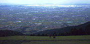
Nobi Plain
Encyclopedia
Plain
In geography, a plain is land with relatively low relief, that is flat or gently rolling. Prairies and steppes are types of plains, and the archetype for a plain is often thought of as a grassland, but plains in their natural state may also be covered in shrublands, woodland and forest, or...
in Japan
Japan
Japan is an island nation in East Asia. Located in the Pacific Ocean, it lies to the east of the Sea of Japan, China, North Korea, South Korea and Russia, stretching from the Sea of Okhotsk in the north to the East China Sea and Taiwan in the south...
that stretches from the Mino
Mino Province
, one of the old provinces of Japan, encompassed part of modern-day Gifu Prefecture. It was sometimes called . Mino Province bordered Echizen, Hida, Ise, Mikawa, Ōmi, Owari, and Shinano Provinces....
area of southwest Gifu Prefecture
Gifu Prefecture
is a prefecture located in the Chūbu region of central Japan. Its capital is the city of Gifu.Located in the center of Japan, it has long played an important part as the crossroads of Japan, connecting the east to the west through such routes as the Nakasendō...
to the Owari
Owari Province
was an old province of Japan that is now the western half of present day Aichi Prefecture, including much of modern Nagoya. Its abbreviation is Bishū .-History:The province was created in 646....
area of northwest Aichi Prefecture
Aichi Prefecture
is a prefecture of Japan located in the Chūbu region. The region of Aichi is also known as the Tōkai region. The capital is Nagoya. It is the focus of the Chūkyō Metropolitan Area.- History :...
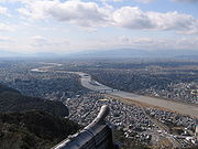
, covering an area of approximately 1800 square kilometre. It is an alluvial plain
Alluvial plain
An alluvial plain is a relatively flat landform created by the deposition of sediment over a long period of time by one or more rivers coming from highland regions, from which alluvial soil forms...
created by the Kiso Three Rivers
Kiso Three Rivers
The refers to the three major rivers that make up the alluvial plain area of the Nōbi Plain of Japan. The three rivers are the Kiso River, the Ibi River and the Nagara River...
(the Ibi
Ibi River
The is a tributary of the Kiso River located in Gifu and Mie Prefectures in Japan. Along with the Nagara and Kiso rivers, the Ibi is the third of the Kiso Three Rivers of the Nōbi Plain. It is one of Japan's first-class rivers...
, Kiso
Kiso River
The is a river in Japan roughly 193 km long, flowing through the prefectures of Nagano, Gifu, Aichi, and Mie before emptying into Ise Bay a short distance away from the city of Nagoya. It is the main river of the Kiso Three Rivers and forms a major part of the Nōbi Plain...
and Nagara
Nagara River
The has its source in the city of Gujō, Gifu Prefecture, and its mouth in the city of Kuwana, Mie Prefecture, Japan. Along with the Kiso River and Ibi River, the Nagara River is one of the Kiso Three Rivers of the Nōbi Plain. Previously, the river was named Sunomata River . With a length of , it...
rivers) and has very fertile soil. It is bordered on the west by the Ibuki
Ibuki Mountains
The are a mountain range straddling the border between Gifu and Shiga prefectures in Japan. After lowering and nearly disappearing in Shiga Prefecture, the range continues as the Suzuka Mountains...
and Yōrō
Yoro Mountains
The are a mountain range straddling the border between Gifu and Mie prefectures in Japan. They form part of the western border of the Nōbi Plain.-Geography:...
mountain range
Mountain range
A mountain range is a single, large mass consisting of a succession of mountains or narrowly spaced mountain ridges, with or without peaks, closely related in position, direction, formation, and age; a component part of a mountain system or of a mountain chain...
s, and to the east by the Owari Hills
Owari Hills
The are a set of hills located in the mid-western part of Aichi Prefecture, Japan. Centuries ago, this area made up the eastern portion of the Owari Domain.The northern section of the hills rises about above sea level...
. Its northern border is marked by the Ryōhaku Mountains
Ryohaku Mountains
The are a mountain range spanning Gifu, Toyama, Ishikawa, Fukui and Shiga prefectures in Japan. It is divided into the Kaetsu Mountains , whose major peak is Mount Haku, and the Etsumi Mountains , whose major peak is Mount Nōgōhaku. The range derives its name from the two major peaks, which both...
and the south by Ise Bay
Ise Bay
Ise Bay is a bay located at the mouth of the Kiso River between Mie and Aichi Prefectures in Japan. Ise Bay has an average depth of 19.5 metres and a maximum depth of 30 metres toward the centre. The mouth of the bay is 9 kilometres wide and is connected to the smaller Mikawa Bay by two channels:...
.
Geography
Wetland
A wetland is an area of land whose soil is saturated with water either permanently or seasonally. Wetlands are categorised by their characteristic vegetation, which is adapted to these unique soil conditions....
, with the level of the land sometimes dipping below sea level
Sea level
Mean sea level is a measure of the average height of the ocean's surface ; used as a standard in reckoning land elevation...
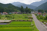
. Because the water levels can change rapidly due to storms, there was often much water damage throughout history, leading to many distinct cultural habits, such as municipalities surrounded by earthen rings (e.g. Wanouchi
Wanouchi, Gifu
is a small town located in Anpachi District, Gifu, Japan.As of July 2011, the town has an estimated population of 9,976. The total area is 22.36 km².- History :...
, Gifu Prefecture). The modern cities of Tsushima
Tsushima, Aichi
is a city located in Aichi Prefecture in the Chūbu region of Japan.As of April 1, 2011, the city has an estimated population of 66,448, with a household number of 25,398, and the density of 2,649.44 persons per km². The total area is 25.08 km²....
and Nagoya in Aichi Prefecture
Aichi Prefecture
is a prefecture of Japan located in the Chūbu region. The region of Aichi is also known as the Tōkai region. The capital is Nagoya. It is the focus of the Chūkyō Metropolitan Area.- History :...
were built on low-level plateau
Plateau
In geology and earth science, a plateau , also called a high plain or tableland, is an area of highland, usually consisting of relatively flat terrain. A highly eroded plateau is called a dissected plateau...
s to ward off water damage and flourished as a result.
The Yōrō Fault is located on the edge of the Nōbi Plains and is the cause of the Yōrō Mountain Range. Sedimentation
Sedimentation
Sedimentation is the tendency for particles in suspension to settle out of the fluid in which they are entrained, and come to rest against a barrier. This is due to their motion through the fluid in response to the forces acting on them: these forces can be due to gravity, centrifugal acceleration...
from the three rivers forms the eastern edge of the plain, which easily shows the declination of the area. The declination is called the Nōbi Tilt (濃尾傾動運動 Nōbi Nadaredō Undō).
The Neodani fault running through the central part of the Nōbi Plain was the cause of the 1891 Mino-Owari earthquake
1891 Mino-Owari earthquake
The was a large earthquake that struck the former provinces of Mino and Owari in the Nōbi Plain area during the Meiji period in Japan. It is also referred to as the Nōbi Earthquake or the Great Nōbi Earthquake . It is the largest known inland earthquake in Japan.-History:The earthquake struck on...
, one of the largest earthquakes to hit Japan's mainland.
Major cities
Aichi Prefecture- Nagoya, IchinomiyaIchinomiya, Aichiis a city located in Aichi, Japan. The city is often called Owari-Ichinomiya to avoid confusion with another Ichinomiya . The pre-expansion city was once part of now-defunct Nakashima District until September 1, 1921....
, KasugaiKasugai, Aichiis a city located in Aichi, Japan. The city was founded on June 1, 1943. As of March 1, 2010, the city had an estimated population of 303,181 and a density of . The total area is ....
, KomakiKomaki, Aichiis a city located in Aichi, Japan. It is commonly associated with the former Nagoya Airport, which is partly located in the city. The other part is in the city of Kasugai. As of January 1, 2008, the city has an estimated population of 149,060 and the density of 2,370 persons per km²...
, InuyamaInuyama, Aichiis a city located near Nagoya in Aichi Prefecture, Japan.In 2010, the city had a population of 75,449 and a population density of 1,010 persons per km². The total area is 74.97 km². The city lies along the edge of Aichi Prefecture, separated from neighbouring Gifu Prefecture by the Kiso River...
, KōnanKonan, Aichiis a city located in Aichi, Japan.As of 2003, the city has an estimated population of 98,806 and the density of 3,274.98 persons per km². The total area is 30.17 km².The city was founded on June 1, 1954.- External links :...
, IwakuraIwakura, Aichiis a city located in Aichi, Japan.As of February 1, 2010, the city has an estimated population of 48,255 and a population density of 4,600 persons per km². The total area is 10.49 km².The city was founded on December 1, 1971.-External links:...
, InazawaInazawa, Aichiis a city located in Aichi, Japan. The city was founded on November 1, 1958. As of February 1, 2010 the city has an estimated population of 136,904 and a population density of 1,730 persons per km²...
, TsushimaTsushima, Aichiis a city located in Aichi Prefecture in the Chūbu region of Japan.As of April 1, 2011, the city has an estimated population of 66,448, with a household number of 25,398, and the density of 2,649.44 persons per km². The total area is 25.08 km²....
Gifu Prefecture
- GifuGifu, Gifuis a city located in the south-central portion of Gifu Prefecture, Japan, and serves as the prefectural capital. The city has played an important role in Japan's history because of its location in the middle of the country. During the Sengoku period, various warlords, including Oda Nobunaga, used...
, ŌgakiOgaki, Gifuis a city located in Gifu Prefecture, Japan. It was incorporated as a city on April 1, 1918. As of July 2011, the city has an estimated population of 160,999 and a total area of .Ōgaki was the final destination for the haiku poet Matsuo Bashō...
, KakamigaharaKakamigahara, Gifuis a city located in the Gifu Prefecture of central Japan. It was founded on 1 April 1963 by the merger of Naka, Sohara, Unuma, and Inaba. Kakamigahara covers a total area of...
, HashimaHashima, Gifuis a city located in the Gifu Prefecture of central Japan.Hashima covers a total area of 87.77 km². As of July 2011 the city has an estimated population of 67,041 inhabitants.The city was founded on 1 April 1954.-External links:*...
See also
- Kiso Three RiversKiso Three RiversThe refers to the three major rivers that make up the alluvial plain area of the Nōbi Plain of Japan. The three rivers are the Kiso River, the Ibi River and the Nagara River...
(Kiso RiverKiso RiverThe is a river in Japan roughly 193 km long, flowing through the prefectures of Nagano, Gifu, Aichi, and Mie before emptying into Ise Bay a short distance away from the city of Nagoya. It is the main river of the Kiso Three Rivers and forms a major part of the Nōbi Plain...
- Nagara RiverNagara RiverThe has its source in the city of Gujō, Gifu Prefecture, and its mouth in the city of Kuwana, Mie Prefecture, Japan. Along with the Kiso River and Ibi River, the Nagara River is one of the Kiso Three Rivers of the Nōbi Plain. Previously, the river was named Sunomata River . With a length of , it...
- Ibi RiverIbi RiverThe is a tributary of the Kiso River located in Gifu and Mie Prefectures in Japan. Along with the Nagara and Kiso rivers, the Ibi is the third of the Kiso Three Rivers of the Nōbi Plain. It is one of Japan's first-class rivers...
) - Ise BayIse BayIse Bay is a bay located at the mouth of the Kiso River between Mie and Aichi Prefectures in Japan. Ise Bay has an average depth of 19.5 metres and a maximum depth of 30 metres toward the centre. The mouth of the bay is 9 kilometres wide and is connected to the smaller Mikawa Bay by two channels:...
- Nagoya